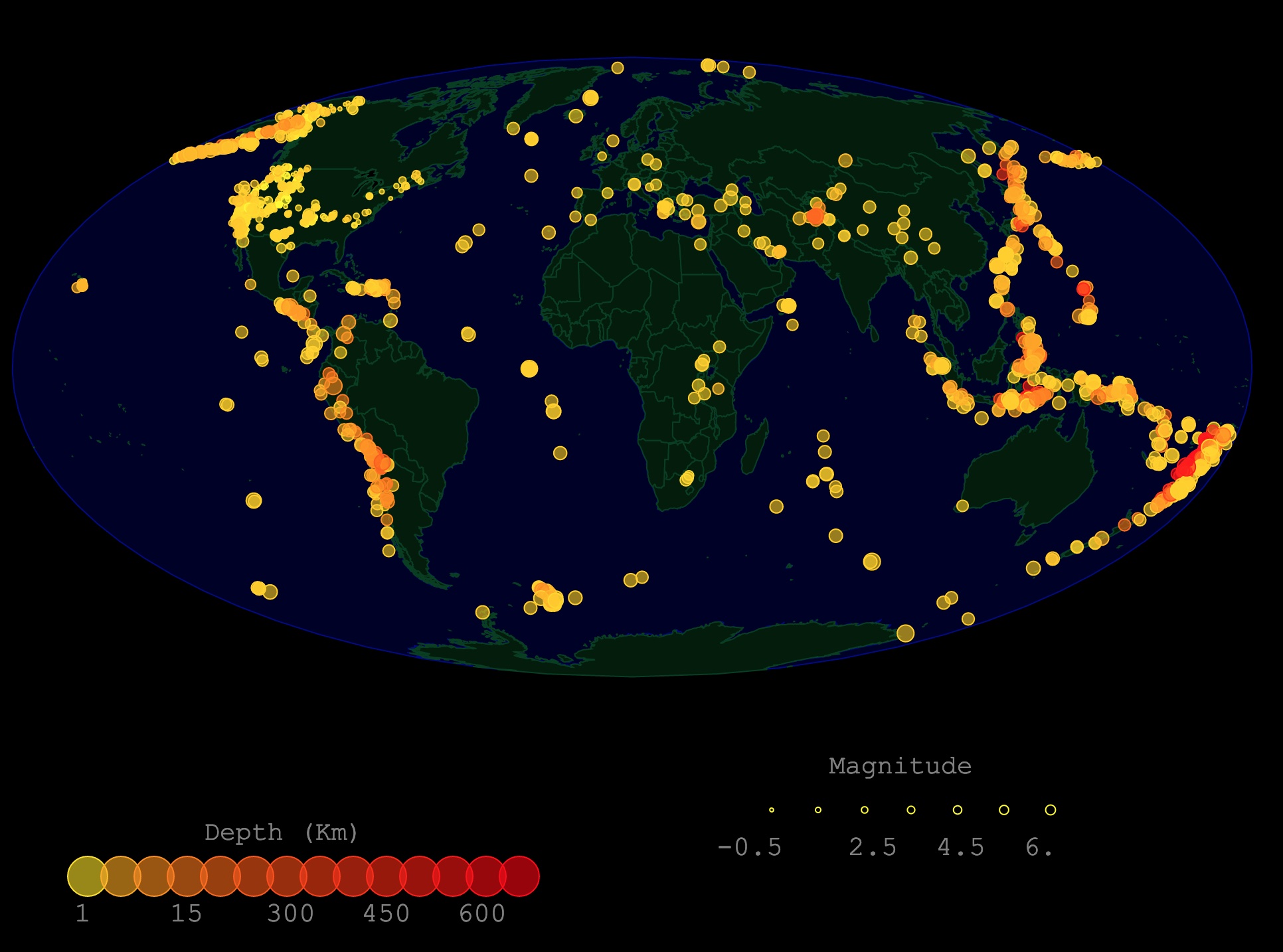
Map of Global Earthquakes
This interactive map shows the location of earthquakes worldwide. It depicts only one month of earthquakes. The circle size shows the magnitude. The color represents the depth. Hover over the map for Place and Magnitude Type. For more information, scroll down.
Earthquakes
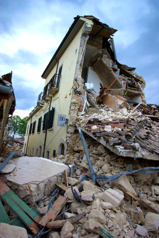
Earthquakes are intense shakings of the Earth's surface. They are the sudden release of stored up energy in the form of seismic waves.
These waves propagate and make the ground shake. This build-up of stress and energy is in response to long-term deformation.
Epicenter
The site where an earthquake begins is called an epicenter.
The strongest shaking is often felt at the epicenter. Still the waves and vibrations can be felt even thousands of miles away.
Earthquake Causes
There are different causes of earthquakes. Nevertheless, earthquakes are mainly caused by the movement of tectonic plates. They usually occur at the boundary of tectonic plates.
Tectonic Earthquakes
The Earth is made up of 4 main layers: the solid crust, a hot semi-solid mantle, a liquid outer core, and a solid inner core.
The lithosphere is made up of the crust and the top of the mantle. The lithosphere is not continuous, but fragmented into about 15 major slabs called Tectonic Plates.
The rigid structure of the plates is floating on top of the viscous mantle drifts. Some lithosphere is created in ridges while older plates cool and sink into the mantle. This movement causes friction between the edges of the plates.
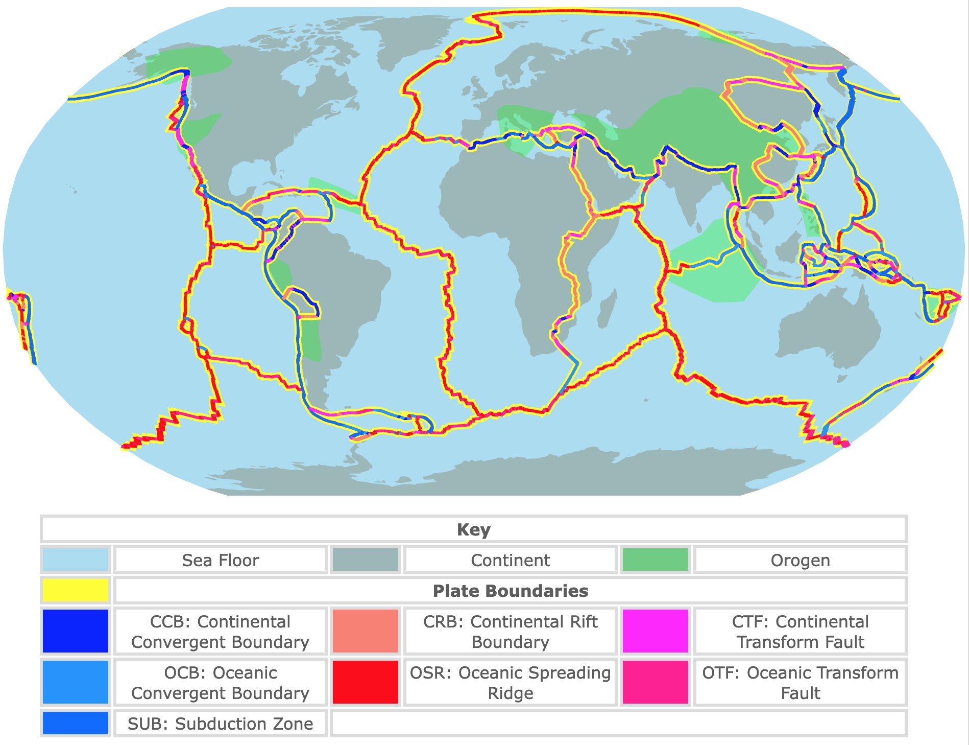
Interested in Tectonic Plates and Boundaries? Check this map about them.
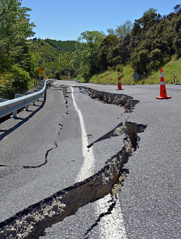
Faults
The friction causes stress. When the pressure gets too large, it creates cracks called faults. The build-up of stress in the rocks on either side of a fault results in gradual deformation.
The deformation exceeds the frictional force holding them in place. The friction cannot hold the rocks together. A sudden slip occurs along the fault. This sudden movement is an Earthquake, British Geological Survey.
During an earthquake, a block of rock on one side of the fault slips in respect to the other.
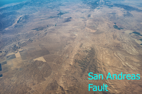
Faults can be very small and thin as a hair. Others are very long and can even be visible from space, like the San Andreas Fault.
There are 3 major types of faults. They are the result of different forces pushing and pulling the lithosphere. Certain types are characteristic of different plate boundaries.
Faults are classified in respect to the angle and direction of the slip along the fault. These are:
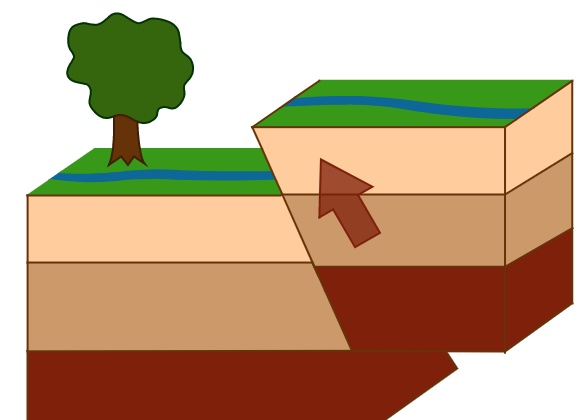
NORMAL FAULT
A block above the fault moves down. These are usually at an angle with respect to the ground.
This fault occurs in response extensions. It is observed in the Western United States at the Basin and Range and along ocean ridges.
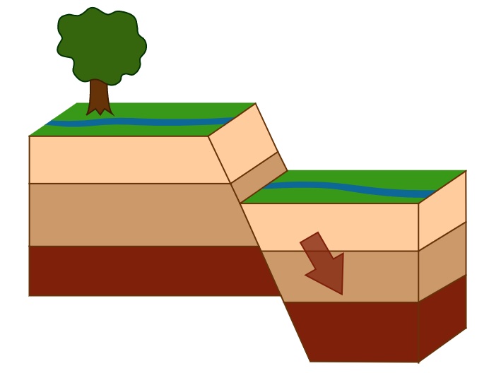
REVERSE FAULT
The block above the fault moves up. These faults are also called thrust faults and are usually at an angle with respect to the ground.
This type of fault is common in areas where one plate is subducted under another, for example, Japan.
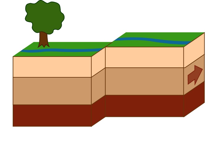
STRIKE-SLIP FAULT
The movement of blocks along the fault is horizontal, they slide past each other. Strike-slip faults are usually vertical.
An example of this fault is the San Andreas Fault.
Induced Earthquakes
These earthquakes are caused by human activity, like tunnel construction, a geothermal project, or fracking.
Volcanic Earthquakes
Volcanic earthquakes are associated with active volcanoes.
They are not as powerful as tectonic quakes; they usually occur near the surface and are only felt near the volcano.
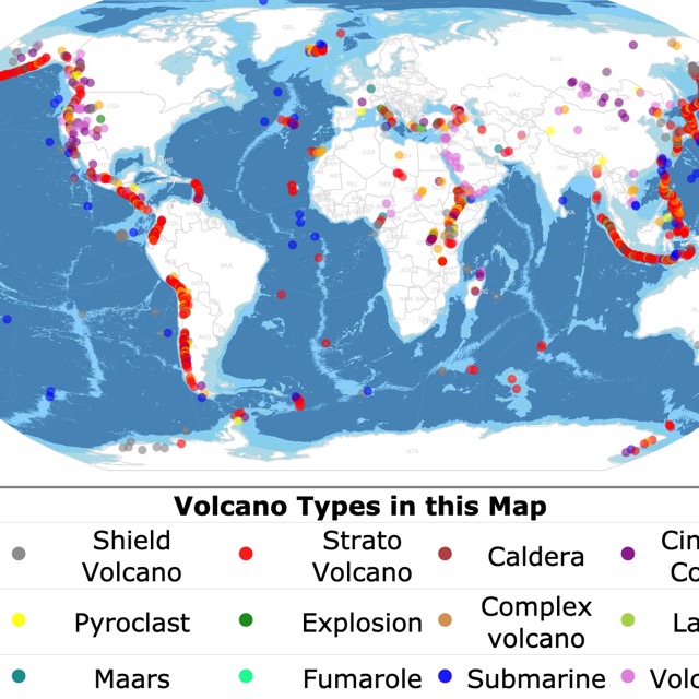
Volcanoes also cause Earthquakes. To learn more, check this map of Volcanoes worldwide
Collapse Earthquakes
Collapse earthquakes are small quakes in underground caverns, mostly in Karst areas or in mining areas.
How to Measure an Earthquake?
Earthquakes can be measured according to magnitude, energy release, and shaking intensity.
Magnitude
Magnitude is the size of the earthquake. Magnitudes are expressed in whole numbers and decimal fractions.
For example, a magnitude of 5 is considered moderate. A magnitude of 6 is a strong earthquake.
The scale uses a logarithmic scale, so each number increases tenfold.
An earthquake of 10.00 magnitude is not possible as the magnitude is dependent on the length of the fault. A longer fault causes a larger earthquake.
A magnitude 10.00 would require a fault to go around the planet, USGS.
Seismometers
The vibrations of earthquakes that travel through Earth are called seismic waves.
The seismic waves are measured through instruments called seismometers. Seismometers measure the movements as a series of zig-zags. The bigger the vibration, the bigger the zig-zag.
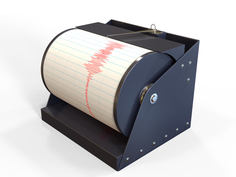
Scientists determine the time, location, and magnitude of an earthquake with information from seismometers. This information is also used to gather information on the rocks where the seismic waves travel through; NASA.
Depth not only provides data about the bottom rocks and layers. Deeper earthquakes result in less shaking on the surface.
Types of Magnitudes
Initially, all magnitude scales were assumed to be equivalent. Nevertheless, large earthquakes are underestimated. This is why earthquakes are now also measured on the physical effects, not just the waveform's amplitude.
The Richter Scale (ML) is the most known scale, but it is mainly used to record small earthquakes. For other earthquakes, the Moment Magnitude (MM) is more accurate.
When you hover over the map, you will see the acronym for each magnitude type. For a complete list of magnitude types and explanations, go to USGS.
Hot water springs are likely found in areas with quakes due to tectonic activity. To find where they are, visit this map of U.S. Hot Springs
Energy Release
Energy release is another measure of an earthquake's size. It measures the potential of damage to man-made structures.
The energy is at different frequencies. They all have to be included to get an accurate number.
Intensity
An earthquake has many intensity values. They are distributed in the area around the earthquake epicenter. The intensity is the shaking measure at each location.
Intensity depends mainly on the distance from the fault rupture area. Intensity is also affected by shake direction and surface geology. Intensity is measured in Roman Numerals, USGS
Where Do Earthquakes Occur?
As mentioned before, most earthquakes are caused by the movement of tectonic plates. Most Earthquakes occur along the edges of the plates or their boundaries.
If you look at the earthquake map above and the map of tectonic plates, you will notice they match.
Earthquake Facts
- The largest earthquake was measured in Bio-Bi Chile in 1975. It had a magnitude of 9.5.
- The largest earthquake in the USA was recorded in southern Alaska in 1975. It had a magnitude of 9.2
- Alaska is the most seismically active state. It has more earthquakes than California.
- Earthquakes can cause huge waves called tsunamis.
- There are several million earthquakes each year.
Affiliate Disclosure
Databayou.com is a participant in the Amazon Services LLC Associates Program, an affiliate advertising program designed to provide a means for sites to earn advertising fees by advertising and linking to Amazon.com. Databayou.com also participates in affiliate programs with Clickbank, CJ, and other sites.
If you plan to study earthquakes, you will like this item found on Amazon.
- Eisco BG0014 Premium Seismograph Model: Perfect for those interested in gadgets and earthquakes.
FOLLOW ME
![]()
![]()
![]()
![]()
Resources for Earthquakes Map
The data for impact craters was obtained by USGS
The Shapefiles for countries were downloaded from Natural Earth.
Made by Luz K. Molina with D3.js.