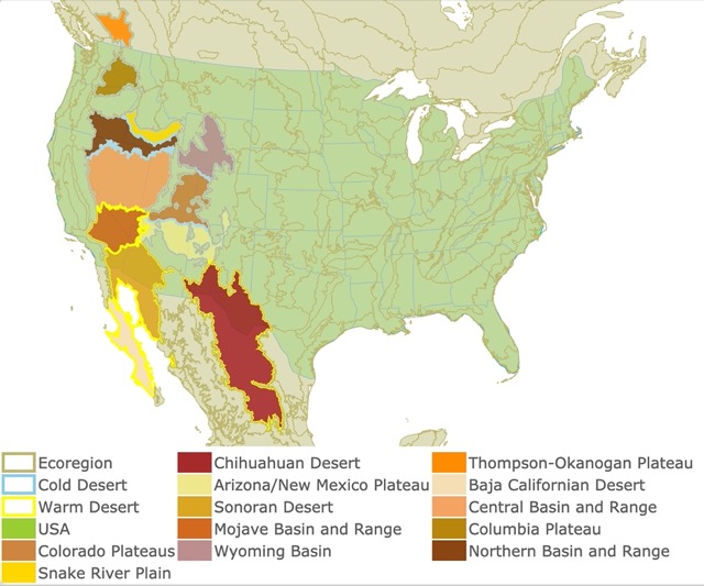
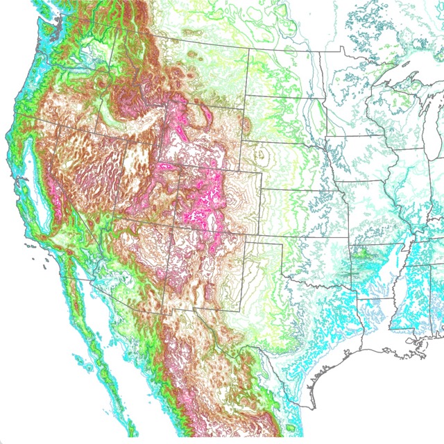
North American Deserts Map
This interactive map shows North American Deserts' locations, classifications, and names. For more detail, zoom in. For ecoregion level, hover over the map. For more information, scroll down.
| Ecoregion | Chihuahuan Desert | Thompson-Okanogan Plateau | |||
| Cold Desert | Arizona/New Mexico Plateau | Baja Californian Desert | |||
| Warm Desert | Sonoran Desert | Central Basin and Range | |||
| USA | Mojave Basin and Range | Columbia Plateau | |||
| Colorado Plateaus | Wyoming Basin | Northern Basin and Range | |||
| Snake River Plain |
North American Deserts of the USA
North American Deserts extend from British Columbia, Canada, in the north to Baja California, Mexico, in the south. They are characterized by aridity, with annual precipitation between 130 to 380 mm. Shrub, succulents, and cactus are the predominant vegetation.
The aridity results from the Sierra Nevada, Cascade Mountains, and the Sierra Madre range as they intercept the wet winter air masses brought by the westerly winds. The Rocky Mountains also block some moisture from the Gulf Coast that crosses the Great Plains. CEC.org.
| Ecoregion Level II | Ecoregion Level III | Location |
| COLD DESERTS | Thompson-Okanogan Plateau | British Columbia |
| Columbia Plateau | State of Washington | |
| Snake River Plain | Idaho | |
| Northern Basin and Range | Oregon and Idaho | |
| Central Basin and Range | Nevada | |
| Wyoming Basin | Wyoming | |
| Colorado Plateau | Colorado, Utah | |
| Arizona/New Mexico Plateau | Arizona, New Mexico | |
| WARM DESERTS | Mojave Basin and Range | California and Nevada |
| Sonora Basin and Range | Southeastern Arizona, Southern California, Mexico | |
| Chihuahuan Desert | Southern New Mexico and Mexico | |
| Baja Californian Desert | Baja California and Baja California Sur |
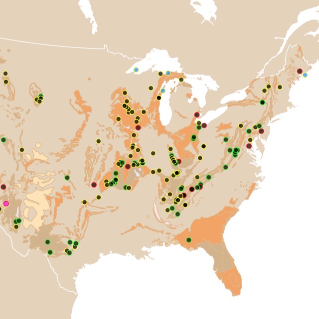
Below is a description of each one of these major North American Deserts. They also include a selection of parks and preserves to visit and enjoy.
For an introduction to the topic, you may buy from Amazon A Walk in the Desert (Biomes of North America). This guide has an overview on one of the most beautiful and fragile ecosystems in North America.
COLD DESERTS
Marked seasonal extremes characterize cold Deserts and semi-deserts. Winter is the wet season distinguished by precipitation in the form of snow.
Thompson-Okanogan Plateau
The Thompson-Okanagan Plateau is in southern British Columbia. This is Canada's only semi-arid shrubland.
The area has an antelope-brush ecosystem with flora and fauna found nowhere else in Canada. This area has 24 endemic species.
The landscape is predominantly shrubs and grasses with no trees.
Common organisms include burrowing owl, peregrine falcon, badger, western red bat, and pallid bat.
This region is the site of the proposed South Okanagan—Similkameen National Park Reserve.
You can visit the Thompson-Okanagan Plateau and stay in the town of Osoyoos, BC. For Hotels and amenities go to Expedia.
Columbia Plateau
The Columbia Plateau covers most of the state of Washington. The Columbia Plateau is an arid sagebrush steppe and grassland, surrounded on all sides by moist, predominantly forested, and mountainous regions.
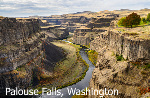
Elevations range from near sea level at the west of the ecoregion to over 9842.52ft (3,000m) to its highest mountains. Vegetation is more abundant in higher elevations.
Although this is a semi-arid land, the ecoregion's fisheries are an essential part of its diversity.
At one time, the Columbia River system sustained one of the largest salmon runs in the world. The area still has isolated desert fishes that are threatened throughout the ecoregion.
This area also supports numerous birds of prey that nest here at higher densities than anywhere else on Earth! Source: Landscope.org
Sun Lakes Falls State Park
Sun Lakes Falls State Park would be the best place to see the scars of the last Ice Age in a beautiful 393 feet (120 m) high, 3.5-mile long cliff, now a National Natural Landmark.
The water bodies present in the Sun Lakes, is great for fishing, swimming, and boating in this otherwise arid desert landscape.
For an overview of desert flowers Amazon has Desert Wildflowers of North America. This book has pages of color photographs and descriptions this guide helps identify over 500 species. They are supported with an overview of desert ecology, a simplified botanical key, and an illustrated glossary of botanical.
Snake River Plain
The Snake River Plain is mainly in the state of Idaho.
This is a dry and intermontane area considerably lower and more gently sloping than the surrounding ecoregions. Mostly because of the available water for irrigation.
A large percentage of the alluvial valleys bordering the Snake River are used to grow sugar beets, potatoes, alfalfa, and vegetables. Cattle feed yards and dairy operations are also common in the river plain. Source: Omernik
Except for the scattered barren lava fields, most of the area has sagebrush grassland vegetation, now used primarily for cattle grazing.
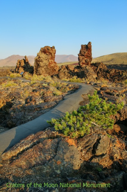
Craters of the Moon National Monument and Preserve
Craters of the Moon is a National Monument and a National Preserve located in Idaho.
The park features the best-preserved flood basalt areas in the continental United States. A great place to hike and explore the weird landscape formed by molten lava fields nearly 15 million years ago. Source: Nationalparks.org.
You may camp at the park or find nearby accomodation with VRBO. There are differetn options, from yurts to houses. For more details click here!
Interested in Deserts? Visit this map of Deserts worldwide
Northern Basin and Range
The Northern Basin and Range is mostly over the states of Oregon and Idaho.
Although arid, this ecoregion is at a higher altitude and cooler than the Snake River Plain to the north. It also has more available moisture and a cooler climate than the Central Basin and Range to the south.
The name describes the landscape, numerous flat basins separated by isolated mountain ranges. Elevations range from 2,070 feet near the Snake River to more than 9,700 feet on Steens Mountain.
This ecoregion receives less than 15 inches of precipitation per year.
This area had large lakes more than 10,000 years ago. These lakes never drained, and the accumulated salt is an important magnet for migratory birds due to the source of invertebrate prey Source: oregonconservationstrategy.org
If you like U.S. geography, you might like this map of U.S. Topography.
Cottonwood Canyon State Park
Cottonwood Canyon State Park is rocky and vast. It has impressive vertical cliffs carved by the John Day River to deep side canyons and arid, rocky grasslands extending for miles.
This park is excellent for hiking, hunting, fishing, and kayaking. Source: stateparks.oregon.gov
Central Basin and Range
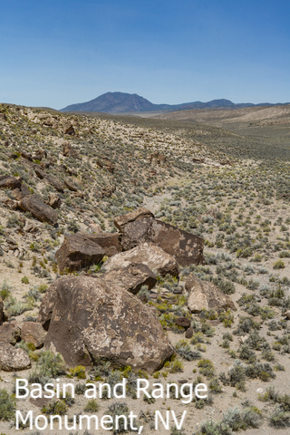
The Central Basin and Range cover most of the state of Nevada.
This ecoregion has either shrub and grass-covered, shrub-covered, or barren.
The Central Basin and Range are internally drained by ephemeral streams and once contained ancient Lake Lahontan.
This ecoregion is warmer and drier than the Northern Basin and Range. It has more shrubland and less grassland than the Snake River Plain.
The land is primarily used for grazing. In addition, some irrigated cropland is found in valleys near mountain water sources. Source: Omernik
The rivers from the central Basin and Range evaporate or seep into the ground before they reach a lake or the ocean.
Some of this water form hot springs, making Nevada the state with the most hot springs in the Union.
Great Basin Natural Park
Located in east-central Nevada, near the Utah border. The park is recognized by ancient bristlecone pines, the oldest known nonclonal organisms, and the Lehman Caves at the base of 13,063 foot (3,982 m) Wheeler Peak well as Wheeler Peak Glacier.
The park's scenic features include Lexington Arch, the Lehman Orchard and Aqueduct, Rhodes Cabin, Stella and Teresa Lakes, and Wheeler Peak Glacier.
The park also has numerous birds, amphibians, and even an endemic trout for animal lovers to see. This is basically a park with a bit of everything. You can take your time to come and see the stars at night! NPS.gov
Las Vegas is relatively close to most of these deserts. If you are planning to reach them, you can start in the Entertainment Capital of the world. For more dates and ticket prices, you can check Expedia here!
Want to learn more about caves or want to find one near your home? Check this map about them and their Geology.
Wyoming Basin
As described by its name, this basin is mainly over Wyoming.
This ecoregion is a broad intermontane basin interrupted by hills and low mountains and dominated by arid grasslands and shrublands.
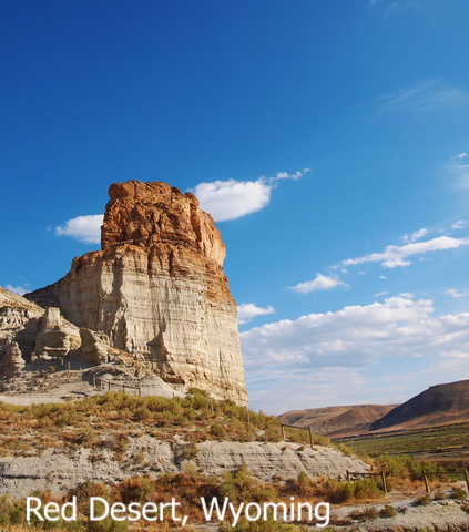
Although many areas lack enough vegetation to support this activity, part of the region is used for livestock grazing.
This ecoregion has major producing natural gas and petroleum fields. The Wyoming Basin also has coal deposits, bentonite, clay, and uranium. Source: Omernik
Fire, wind, grazing, and changes in precipitation and temperature are the major disturbances in the ecoregion.
Some distinct wildlife in this region is the prairie dogs, coyotes, swift foxes, pronghorn, and bison Source: Worldwildlife.org.
Hot Springs State Park
As its name says, this park has hot springs with a constant temperature of 128 degrees Fahrenheit. The park offers bathhouses for visitors to enjoy therapeutic baths.
The park also offers 6.2 miles of hiking trails, fishing, and a boat ramp.
Another major park attraction is the bison herd, which can be viewed from the visitor's vehicle. Source Wyoparks.ywo.gov
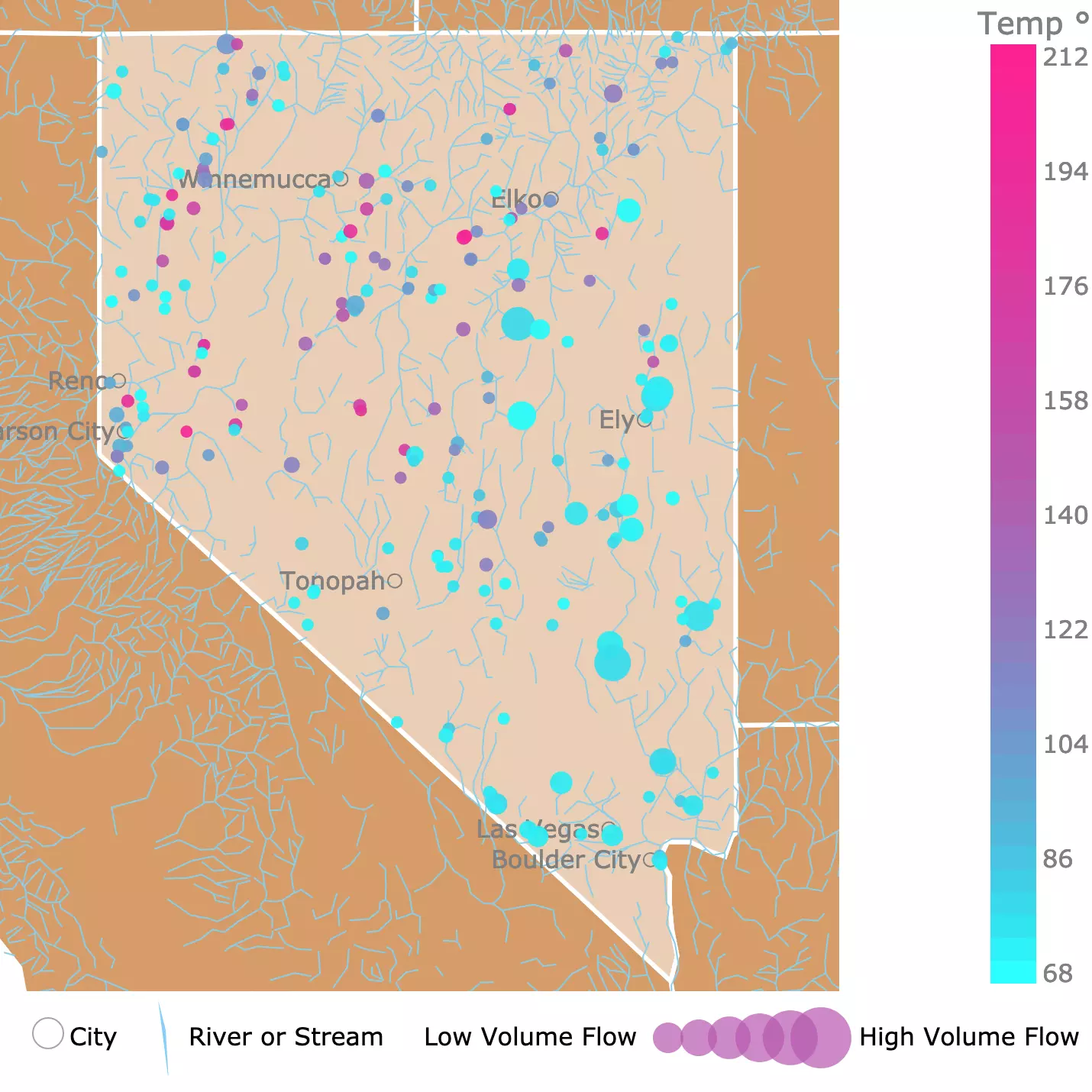
Map of Hot Springs in Nevada
Colorado Plateaus
The Colorado Plateau is in the states of Utah and Colorado.
This ecoregion is an uplifted, eroded, and dissected tableland. Its benches, mesas, buttes, salt valleys, cliffs, and canyons are formed by thick sedimentary rock layers.
Precipitous side-walls mark abrupt changes in local relief, often of 1,000 to 2,000 feet or more. Wind and water erosion have helped sculped this incredible landscape.
The region contains a greater extent of pinyon-juniper and Gambel oak woodlands than the Wyoming Basin up north. Summer moisture from thunderstorms supports warm-season grasses. Many endemic plants occur, and species diversity is high.
Several national parks are located in this ecoregion and attract many visitors to view their arches, spires, and canyons. Source: Omernik. For this reason, this area is known as the "Grand Circle", and it is one of the world's greatest concentrations of outstanding natural features. Here is a list of the best of them, source: NPS.gov.
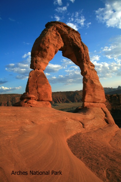
- Arches National Park: The park has over 2,000 natural stone arches and hundreds of soaring pinnacles, massive rock fins, and giant balanced rocks.
- Bryce Canyon National Park: This park has the highest concentration on Earth of Hoodoos and irregular columns of rock.
- Canyonlands National Park: Is a great place to explore the countless canyons and incredibly formed buttes carved by the Colorado River and its tributaries.
- Capitol Reef National Park: Is filled with cliffs, canyons, domes, and bridges in the Waterpocket Fold. This fold is a geologic monocline, a wrinkle on the Earth, extending almost 100 miles.
- Zion National Park: Located in Utah, at the junction of the Colorado Plateau, Great Basin, and the Mojave Desert. This park has massive sandstone cliffs of cream, pink, and red, where visitors can experience wilderness in a narrow slot canyon.
These parks are amazing but camping while visiting them is not for everyone. Expedia has many hotels where you can stay while completing the Grand Circle. For rates and locations, click here!
The best places to find fossils are deserts. To learn more, check this map.
Arizona/New Mexico Plateau
The Arizona/New Mexico Plateau, as described by the name, is in the states of Arizona and New Mexico.
It represents a transitional area between the drier shrublands and wooded higher relief of the Colorado Plateaus in the north and the lower, hotter, less vegetated Mojave Basin to the west.
Local relief in the region varies from a few feet on plains and mesa tops to well over 1000 feet along tableland side slopes.
"Gunnison prairie dogs are a keystone species in many of the sagebrush ecosystems, and their burrows provide habitat for other wildlife, including burrowing owls, weasels, badgers, and a variety of snakes." Source: Omernik Level III Ecoregions for the US.
- Grand Canyon National Park: The park is home to the immense Grand Canyon, a mile (1.6 km) deep and up to 18 miles (29 km) wide, with layered bands of colorful rock revealing millions of years of geologic history.
- Mesa Verde National Park protects nearly 5,000 known archeological sites, including 600 cliff dwellings.
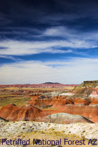
- Petrified National Forest: This park is known for its fossils, especially fallen trees that lived in the Late Triassic Epoch.
- Horseshoe Bend is a horseshoe-shaped meander of the Colorado River. The overlook is 1000ft (304m) drop with incredible scenery.
WARM DESERTS
Warm deserts have higher temperatures and greater evaporation rates. Precipitation comes in the form of rain.
Mojave Basin and Range
The Mojave Basin and Range is mainly in California and Nevada. In the Mojave Basin, creosote bush, white bursage, Joshua tree, other yuccas, and blackbrush are typical.
On mountains, sagebrush, juniper, and singleleaf pinyon occur. At high elevations, some ponderosa pine, white fir, limber pine, and bristlecone pine may be found.
Heavy use of all-terrain vehicles and motorcycles in some areas has made the soils susceptible to wind and water erosion. Most of this Ecoregion is federally owned, and grazing for livestock is limited by the lack of water and forage.
Valley of Fire State Park
Located in southern Nevada, the Valley of Fire State Park is renowned for the bright red sandstone nestled in tan limestone. The park is also known for its petrified trees and petroglyphs over 2,000 years old.
Joshua Tree National Park
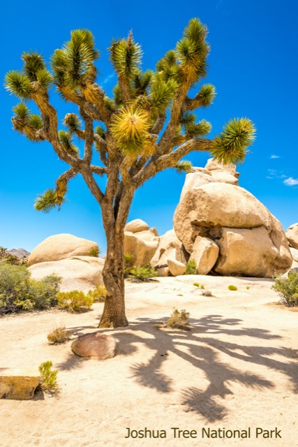
The park takes its name from the Joshua tree, Yucca brevifolia, a member of the Agave family. Native people were the first to take advantage of this tree.
Today this yucca tree is sought after for its grotesque appearance, a surprising sight in the landscape.
Many birds, mammals, reptiles, and insects depend on the Joshua tree for food and shelter.
The park has canyons, oases, boulders, and bulbous rocks. There is also a variety of wildlife, including jackrabbits, bobcats, coyotes, and the Mojave desert tortoise.
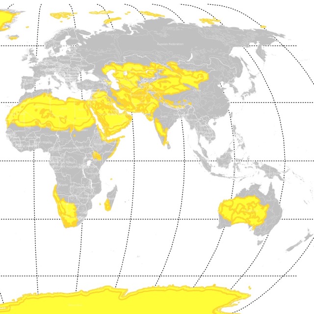
The best sites to find meteorites are deserts. For more details, visit this map!
Sonoran Basin and Range
The Sonoran Basin and Range is mainly in Arizona, California, and Mexico. Similar in topography to the Mojave Basin and Range. This ecoregion contains scattered low mountains and has large tracts of federally owned lands, a large portion of which are used for military training.
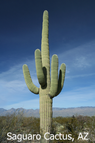
"The Sonoran Basin and Range is slightly hotter than the Mojave and contains large areas of palo verde-cactus shrub and giant saguaro cactus". "Other typical Sonoran plants include white bursage, ocotillo, brittlebush, creosote bush, catclaw acacia, cholla, desert saltbush, prickly pear, ironwood, and mesquite" Source: Omernik.
Sonoran Desert National Monument
The Sonoran Desert National Monument contains magnificent examples of the Sonoran Desert landscape. The national monument is the most biologically diverse of the North American deserts. The monument captures a significant portion of that diversity.
The most noticeable aspect of the plant community within the monument is the extensive saguaro cactus forest.
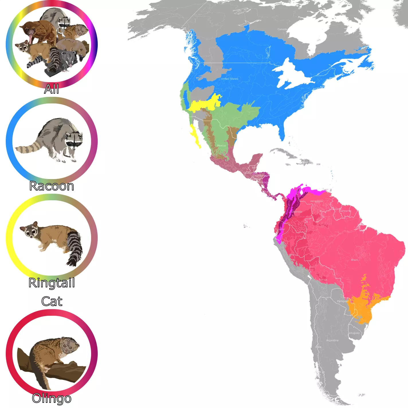
Geographic Range of Ring-Tailed Cats!
Chihuahuan Desert
This desert extends more than 500 miles from New Mexico and Texas, south into Mexico. The Chihuahuan desert is the largest desert in North America.
Because of the area's high altitude, between 3,000 to 5,000 feet, winters and nights are cool, while summer days can reach temperatures over 100 degrees Fahrenheit.
The mountain ranges are a geologic mix of Tertiary volcanic and intrusive granitic rocks, Paleozoic sedimentary layers, and some Precambrian granitic plutonic rocks.
Outside the major river drainages, such as the Rio Grande and Pecos River in New Mexico and Texas, the landscape is largely internally drained.
Vegetation is predominantly desert grassland and arid shrubland, except for high elevation islands of oak, juniper, and pinyon pine woodland.
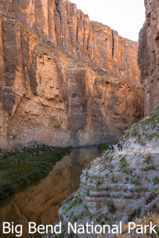
Big Bend National Park
Big Bend is too big to see in a single day! The Big Bend is named for the vast curve of the Rio Grande in remote southwest Texas. The area has over one million acres of public land, including Big Bend National Park and Big Bend Ranch State Park.
It is a beautiful natural region with a complex and fascinating history.
The park's amenities include hiking, camping, river running, horse riding, mountain bicycling, birding, jeep touring, and abundant sightseeing opportunities on paved and improved roads.
Baja Califronia Desert
The Baja Califronia Desert occupies most of Baja California and Baja California Sur, Mexico.
This region is defined by its north-south mountain ranges. With elevations around 3,280 - 4,921 feet (1,000 to 1500m). The region also has significant coastal dunes.
The climate is subtropical, with hot summers and mild winters. Thanks to the California Current, some areas are always cool.
Dominant plants are ragweed, redstem, agave, datilillo, sour pitaya, and cacti.
Because the peninsula is relatively isolated, there is a high species endemism. 23% of the plants are found nowhere else.
Some organisms include the golden eagle, burrowing owl, Costa's hummingbird, lizards, bees, scorpions, and spiders.
El Vizcaino Biosphere Reserve
This is Mexico's largest protected area.
The park's coastal lagoons protect grey whales, harbour seals, elephant-seals, and California sea lions.
This park also protects mule deer, bighorn sheep, and puma; One Earth.
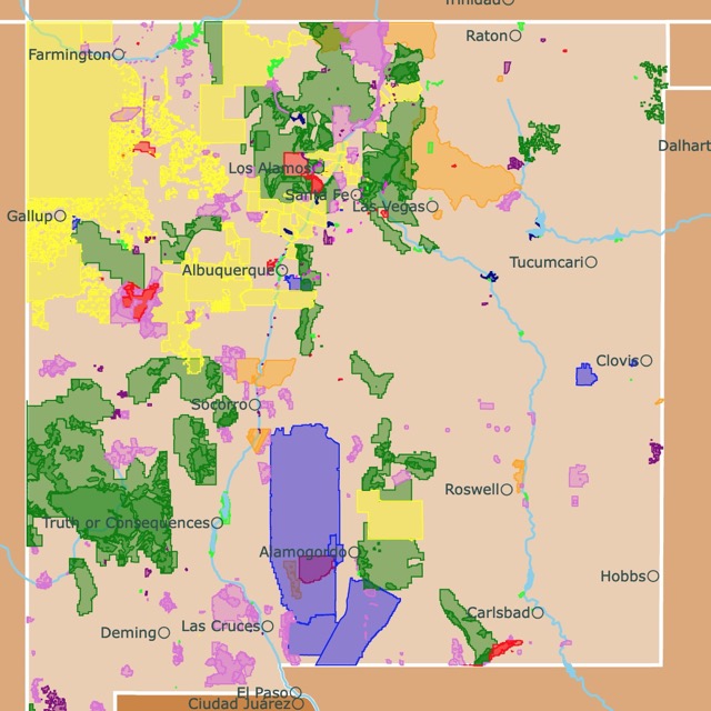
Interested in what New Mexico has to offer? Check this map of New Mexico parks
FOLLOW ME
Desert Map Resources
This map displays North American Ecoregions Level III. At the same time, it highlights the Deserts of North America. The data comes from the U.S. Environmental Protection Agency EPA. The shapefiles were downloaded from ArcGIS.
The shapefiles for the states were downloaded from Natural Earth.
Most of the descriptive sections come labeled as Source: Omernik, which corresponds to Omernik Level III Ecoregions for the US.
This map will be updated with new data! To receive updates on this and more nature maps, join my email list!!!!!!!
Made by Luz K. Molina with D3.js.