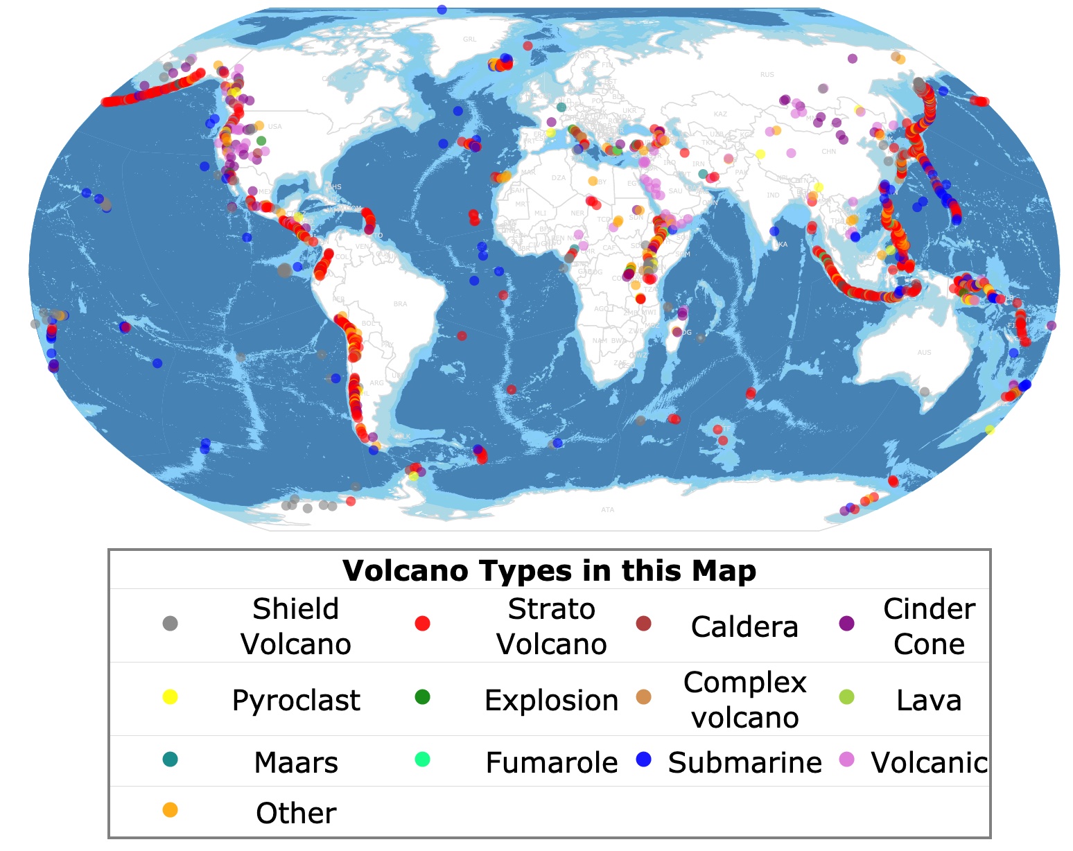
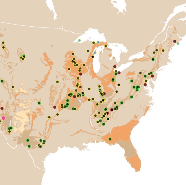
World Map of Volcano Types
This interactive map shows the locations of Volcanoes worlwide, their classification, and their names. For more details, zoom in. For more data, hover over the map. For more information, scroll down.
| Volcano Types in this Map | |||||||
| Shield Volcano | Strato Volcano | Caldera | Cinder Cone | ||||
| Pyroclast | Explosion | Complex volcano | Lava | ||||
| Maars | Fumarole | Submarine | Volcanic | ||||
| Other | |||||||
What is a Volcano
A volcano is an opening on Earth's crust. These openings allow material warmer than its surroundings to escape from its interior.
The material that escapes or erupts can be lava, small rocks, volcanic ash, or steam.
Deep underneath a volcano is molten rock called Magma. Magma is lighter than the surrounding rock. With the pressure of the gases in it, magma rises and forces its way through cracks in Earth's crust.
As it rises, it breaks through the Earth's crust as an eruption. Once it is out, the Magma is called lava. The way these eruptions occur depends on the lava's gas content and chemical composition.
Volcanoes with low gas content have runny and slow erupting lava. Examples of this are the volcanoes in the Hawaiian Islands.
Volcanoes with lots of trapped gas, high viscosity, and silica have more explosive eruptions like that of Mount St. Helens in the State of Washington.
Explosive eruptions are accompanied by strong earthquakes.
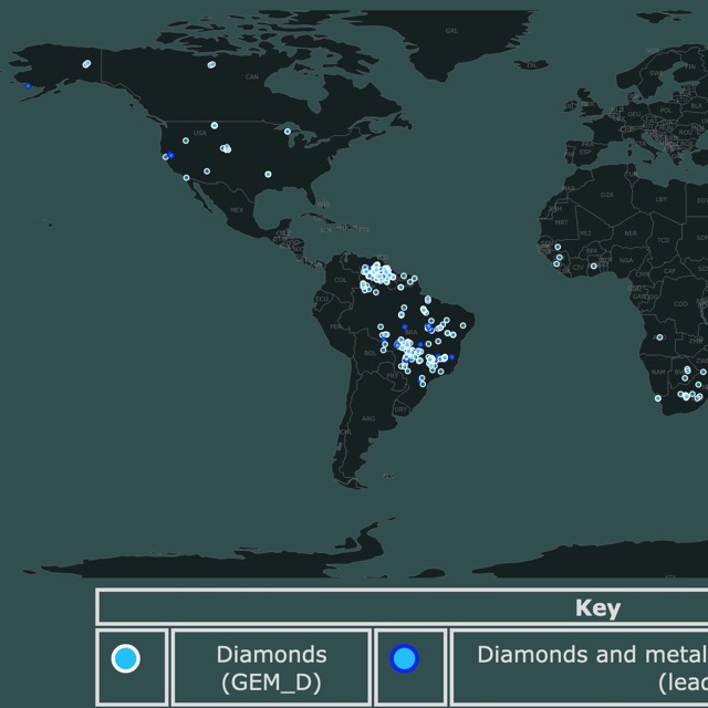
If you are interested geology, mining, and precious stones, visit this Diamond Map
Where are Volcanoes Located
Plate Boundaries
Most volcanoes are found at the edges of Tectonic Plates. These edges can be under land or under oceans.
Plate Tectonics is a theory that explains how the Earth's outermost layer is divided into plates. These plates move over the molten upper portion of the Earth's mantle. Convection currents under the plates move the plates in different directions.
This motion means that plates come together and spread apart. There are margins where the tectonic plates meet, and there is no friction. These are called passive margins, like the United States East Coast.
Active margins are sites where plates meet and collide. In this collision, one plate can go underneath the other. This will result in a trench and a lifting of a continental plate.
The plate that sinks goes into great heat and pressure. This material mixes and melts, turning into liquid magma.
This molten magma is more buoyant than the material above. This buoyant magma eventually migrates to the surface in the form of volcanoes.
A clear example of this collision of plates is the Western Coast of South America. On the map above, this margin is covered with volcanoes.
The Plate under the Pacific Ocean is going underneath the South American Continent, creating the Andes mountains and a chain of volcanoes with it. The same situation occurs on the other side of the Pacific, where Asia meets the Ocean, Open Geology.
On the map above, the lighter shade of blue on the ocean floor represents lower depths. These are usually divergent margins or where the tectonic plates are separating.
These areas are also active. They are called mid-ocean ridges. You can see them clearly in the middle of the Atlantic Ocean. These areas have volcanic activity due to the movement of magma.
Hotspots
Some chains of volcanoes form in the interior of tectonic plates. These volcanoes get progressively older away from the largest and most active volcano.
Hotspots are large plumes of hot mantle that rise from deep within the Earth. As the plate moves, a chain of volcanos is formed.
Examples of hotspots include Hawaii, Iceland, and Yellowstone National Park. Source: USGS.
If you are fascinated with Earth Sciences and would like to pursue this field, Coursera can help you. It currently offers a course in Writing in the Sciences. For more information visit this link!
Volcano Types
Volcanoes are characterized by their composition, structure, and eruption. They also vary, depending on the rocks and minerals that make them up.
Below, you can read the four major types of Volcanoes. Source: http://ete.cet.edu/gcc/?/volcanoes_types/.
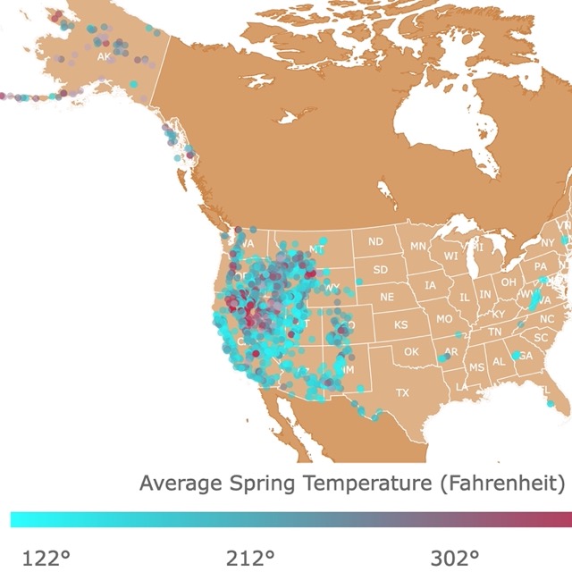
If you are interested in experiencing geology in a more relaxed way, visit this map of U.S. Hot Springs
Cinder Cones
Cinder cones are the simplest type of volcanoes.
A cinder (also called scoria) is a pyroclastic material. These are extrusive igneous rocks that come from fragments of solidified lava. Cinders look like dark pumice.
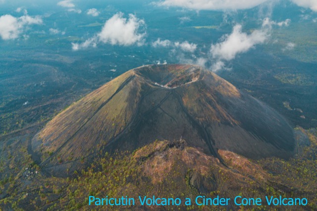
When cinder volcanoes erupt, powerful blasts throw molten rocks, ash, and gas into the air. These pieces dry and fall as pieces of cinder that accumulate near the vent, forming a circular cone.
Compared to other volcanoes, Cinder Cones have short and explosive eruptions.
Most cinder cones have a bowl-shaped crater and steep slopes.
Cinder cones are mainly made of accumulated, loose, grainy cinders and almost no lava. They are usually small volcanoes of about one mile in diameter and 1,000 feet (304m)high.
Cinder Cones have steep sides and a small crater on top. It common to find Cinder cones as part, next, or at the flanks of other volcanoes.
They are usually formed later in an eruption when activity has localized to one or more discrete vents.
Cinder cones can form in convergent plate boundaries and in the middle of tectonic plates in hotspots.
Mount Etna in Sicily is covered with Cinder Cones. Paricutin Volcano in Mexico is another well-studied example of a Cinder Cone Volcano.
Other examples include the Capulin volcano in New Mexico and Wizard Island in Crater Lake National Park, a cinder cone formed after the caldera-forming eruption.
As you can see on the map, this type of volcano is common in Western North America.
Shield Volcanoes
Shield volcanoes are mainly made of thin lava built in the central vent. These volcanoes have very little pyroclastic material. Therefore, Shield volcanoes form from nonexplosive eruptions of low-viscosity magma.
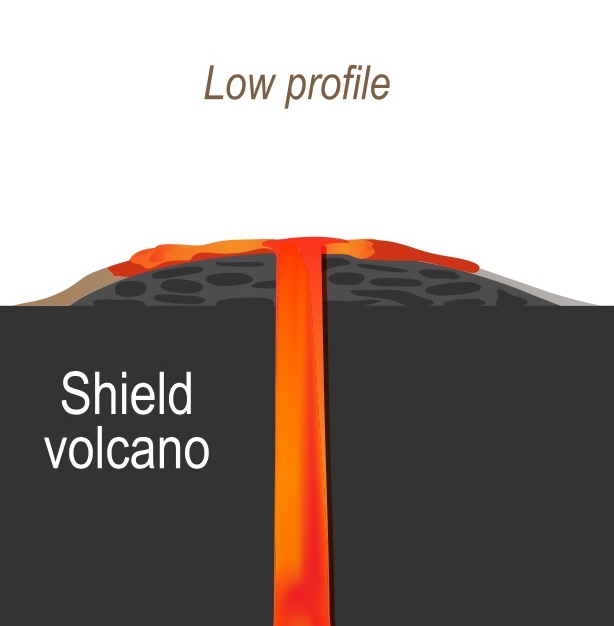
After lava pours out in all directions from the central vent or group of vents, it builds a broad, gentle, sloping, flat cone.
These volcanoes tend to have large calderas at their summits.
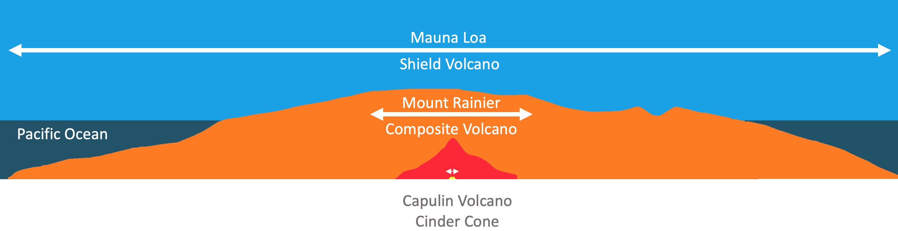
Because they build up slowly through accretion, this type of volcano can be hundreds of miles across and can be, on average, 2,000 feet (609m) high.
Shield volcanoes have slopes from 10 degrees to 5 degrees at the top. These are gentle slopes.
Some eruptions will pour basaltic lava from long fissures instead of central vents. They can flood surrounding areas with successive flows, eventually forming plateaus.
They have that name because they look like shields when viewed from above.
Shield volcanoes are found in hotspots.
A well-known example of a shield Volcano is Mauna Loa on Hawaii's "Big" island.
If you want to read more in-depth information about active and new volcanoes, here is a link from Amazon to Volcanoes of the World. It contains a directory of volcanoes with a chronology of eruptions.
Stratovolcanoes or Composite Volcanoes
Stratovolcanoes are made of layers of lava flows interlayered with sand or gravel from volcanic rock or ash. The volcano is built up by the accumulation of material that erupted.
These volcanoes are usually 10-20 miles in diameter and can reach around 10,000 feet (3,048m).
The slopes of this type of volcano start at 10 degrees and reach 30 degrees at the top. Hence, these are relatively narrow base volcanoes with steep slopes.
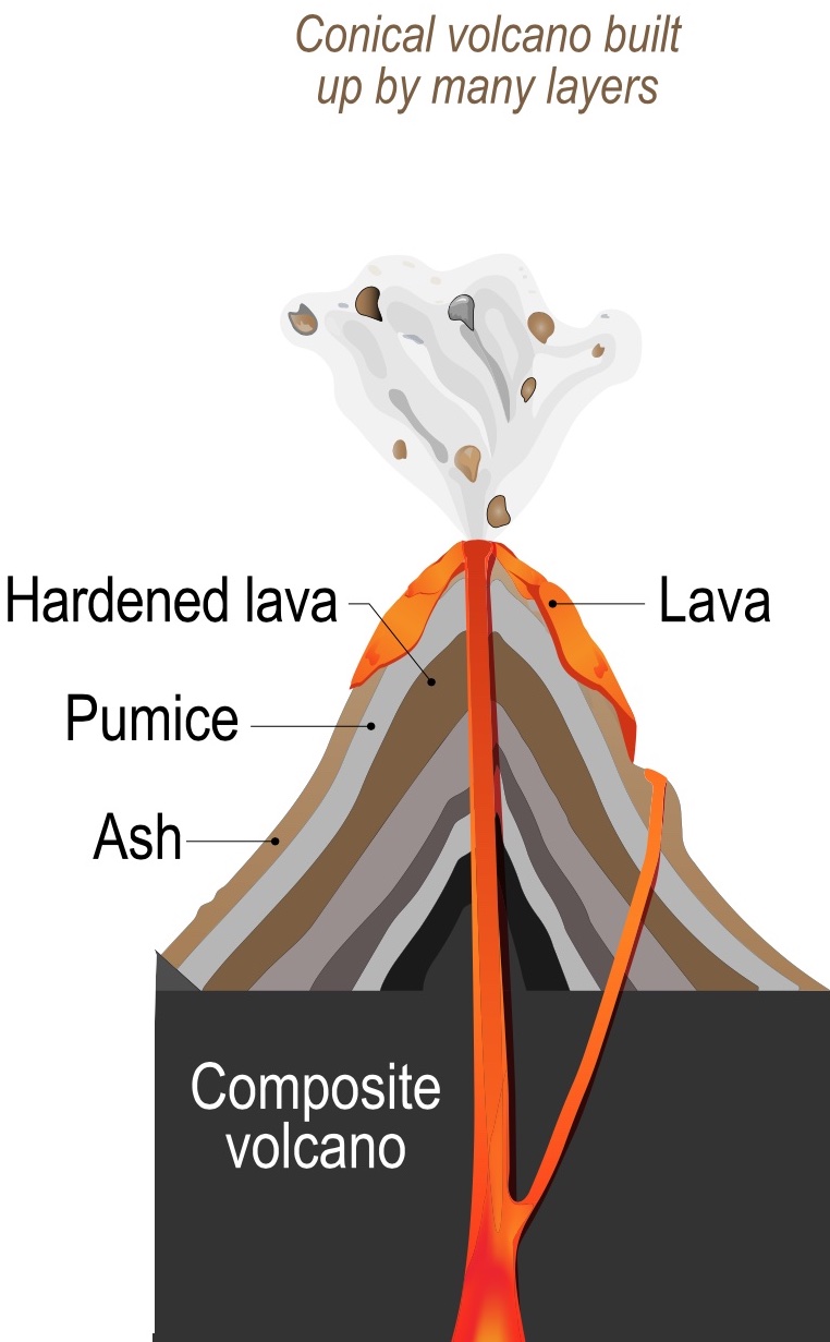
Their interlayer is usually 50% lava and 50% pyroclastic material.
Pyroclastic materials are mixtures of hot, dry rock, cinders, and gases that erupt at high speeds and strong explosions.
Lava may escape through the cracks in the crater wall or through fissures on the sides of the cone.
Lava that solidifies in the fissures forms dikes that will act as ribs, giving more strength to the cone USGS.
When these volcanoes become dormant, erosion slowly degrades the cone. Then, the hardened magma of the conduit and dikes are exposed. These are eventually eroded away as well.
Some of the most conspicuous and beautiful mountains, are Composite volcanoes.
Famous stratovolcanoes include Krakatoa in Indonesia, which had a catastrophic eruption in the 1800's and Mount Vesuvius in Italy.
The tallest Stratovolcano in the U.S. is Mount Rainier, with a summit elevation of 14,410 feet (4,392m). Another famous Stratovolcano is Mount Fuji in Japan.
These volcanoes are depicted in red on the map above.
Lava Domes or Volcanic Domes
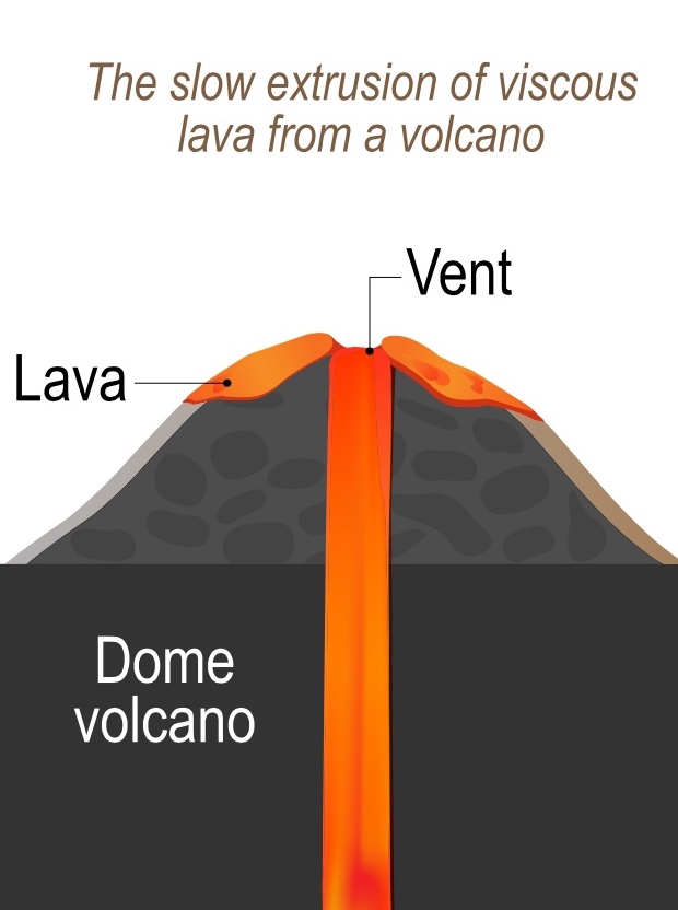
Lava Domes are made of lava flows that are too thick to move or flow away from the vent.
Eventually, the lava accumulates and squeezes near the vent as a giant pile.
This accumulation may result in spines or tops resembling muffins or tongues.
Some domes form ragged lumps or spines over the volcanic vent, whereas others form short, steep-sided lava flows known as "coulees.
This type of volcano is quite dangerous because it grows from inner expansion.
As the lower magma accumulates, the cold, hard top can shatter and spill hot rocks down its flanks.
An example of a Lava Dome volcano is Katmai Volcano in Alaska USGS.
Other types of volcanoes
The previous four types of volcanoes are the most common. Other types are on the map. Here is a brief description of some of them.
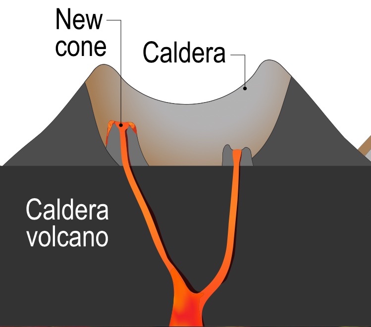
Strato Volcanoes and Shield Volcanoes can lose their tops following a large explosion. The result is the collapse of the top, leaving a depression that may later form a Caldera.
The diameter of a Caldera can be 15 miles to 60 miles long.
A Maar is a broad, flat volcanic crater caused by an explosion that occurs when groundwater comes into contact with hot lava or magma.
A maar usually fills with water to form a relatively shallow crater lake.
A "complex volcano" has one main vent or cone and several eruption points that have changed over time..
Fumaroles are openings on the Earth's crust that emit volcanic gases like sulfur dioxide, carbon dioxide, or steam.
Fumaroles may happen as fissures near active volcanoes or areas where magma raised close to the surface but never erupted. Source: USGS
Many volcanoes are vents or fissures under the ocean. These are the Submarine volcanoes. Earth's most productive volcanic systems are under the water at an average depth of 8,500 feet (2,600 m).
These are the Submarine Volcanoes, and they are likely found under the mid-ocean ridges.
Do you like Geology maps? Check this map of U.S. caves
Volcano Map and Sources
This map only shows volcanoes that have been active in the last 10,000 years or during the Holocene. The data is a collection of information by Smithsonian Institution volcanologists summarizing 1,509 volcanoes.
The Shapefiles for the volcanoes and their information were downloaded from Stanford.
The Shapefiles with the depths and countries were downloaded from Natural Earth.
Thank you for Subscribing!
Follow Me
Made by Luz K. Molina with D3.js.