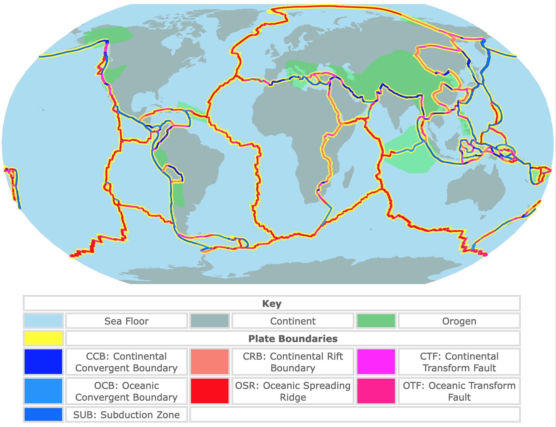
Tectonic Plates and Boundaries Map
This map shows Tectonic Plates in light blue. Continents are shown in light brown. It also indicates Plate Boundaries in yellow. To see the name of each plate or boundary type, hover over the map. For more details, zoom in. Scroll down if you want to read more about Tectonic Plates and Boundaries.
| KEY | |||||
|---|---|---|---|---|---|
| Sea Floor | Continent | Orogen | |||
| Plate Boundaries | |||||
| Convergent Bondaries | Divergent Boundaries | Transform Boundaries | |||
| CCB: Continental Convergent Boundary | CRB: Continental Rift Boundary | CTF: Continental Transform Fault | |||
| OCB: Oceanic Convergent Boundary | OSR: Oceanic Spreading Ridge | OTF: Oceanic Transform Fault | |||
| SUB: Subduction Zone | |||||
| Major Plates | |
|---|---|
| Identifier | Plate Name |
| AF | Africa |
| AN | Antarctica |
| EU | Eurasia |
| IN | India |
| AU | Australia |
| NA | North America |
| PA | Pacific |
| SA | South America |
| Minor Plates | |
| AR | Arabia |
| CA | Caribbean |
| CO | Cocos |
| JF | Juan de Fuca |
| NZ | Nazca |
| PS | Philippine Sea |
| SC | Scotia |
| CL | Caroline |
| BU | Burma |
| AM | Amur |
| SU | Sunda |
| OK | Okhotsk |
| YA | Yangtze |
| NH | New Hebrides |
| SO | Somalia |
| Microplates | |
|---|---|
| Identifier | Plate Name |
| AP | Altiplano |
| AR | Arabia |
| AS | Aegean Sea |
| AT | Anatolia |
| BH | Birds Head |
| BR | Balmoral Reef |
| BS | Banda Sea |
| CR | Conway Reef |
| EA | Easter |
| FT | Futuna |
| GP | Galapagos |
| JZ | Juan Fernandez |
| KE | Kermadec |
| MA | Mariana |
| MN | Manus |
| MO | Maoke |
| MS | Molucca Sea |
| NB | North Bismarck |
| ND | North Andes |
| NI | Niuafo'ou |
| ON | Okinawa |
| PM | Panama |
| RI | Rivera |
| SB | South Bismarck |
| SL | Shetland |
| SS | Solomon Sea |
| SW | Sandwich |
| TI | Timor |
| TO | Tonga |
| WL | Woodlark |
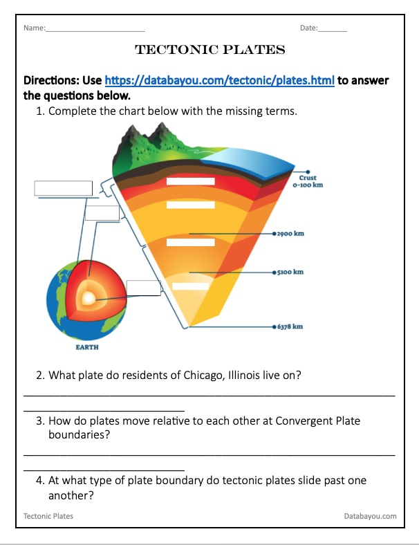
Internal Earth's Structure
Earth's internal structure can be divided into different ways. Dividing it into mechanical layers, you find the Lithosphere and the Asthenosphere.
Lithosphere
The outermost layer of Earth is called the Lithosphere. The Lithosphere is solid and brittle. The atmosphere covers the Lithosphere and lies on top of the Asthenosphere.
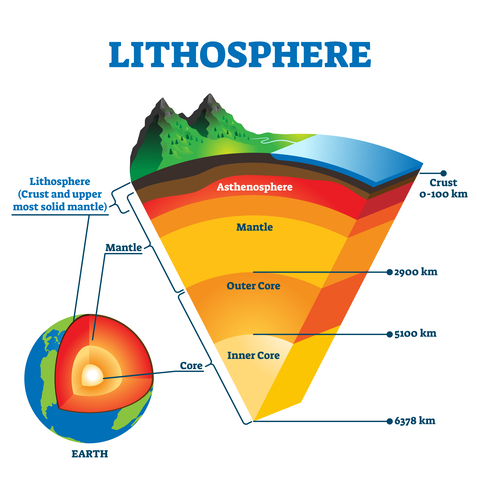
The Lithosphere is relatively cool, and the rock is resistant to deformation.
The Lithosphere comprises two layers: the Earth's Crust and part of the Mantle. Source: Waterencyclopedia.com
Oceanic Crust
The Ocean Crust is under the sea, and it has an almost constant thickness. It usually measures between 3.2 - 4.3 miles (7 - 5 Km).
Because its main component is Basalt, the average density of the Oceanic Crust is 3.0g/cm3.
Continental Crust
The Continental Crust is under the continents. Its thickness is variable, with an average of 18.6 miles (30Km). In areas with mountains, it can reach a depth of 62.1 miles (100Km).
The Continental Crust is mainly made up of Granite. Granite is rich in minerals such as feldspar and quartz (aluminum and silicon). Because of its composition, it has a lower density than the Ocean Crust, averaging 2.7g/cm3.
Asthenosphere
The asthenosphere is below the Lithosphere. The asthenosphere is viscous and is made of semi-plastic rock. It is believed the Asthenosphere moves very slowly.
The Asthenosphere is entirely made of the Mantle. You could say the Lithosphere floats on top of the Asthenosphere.
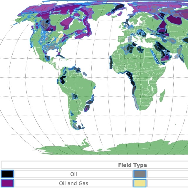
World Map of Oil and Gas Fields
Tectonic Plates
The lithosphere is broken down into large tectonic plates or lithospheric plates. These are sections into which the lithosphere is cracked.
The Earth is divided into 7 major and 15 minor plates listed above and represented on the map. This list shows 8 Major pates because the Indian and the Australian Plate are considered to be fused into one.
Tectonic Plates are, on average 77.6 miles (125 Km), reaching maximum thickness at mountain ranges. Geological society.
Tectonic plates may be composed of Oceanic Crust and Continental Crust, like the African Plate and the South American Plate.
The image below shows me pointing at the North American Plate on one side and the Eurasian Plate on the other. It was taken at the divergent rift valley in Iceland (near Reykjavík).
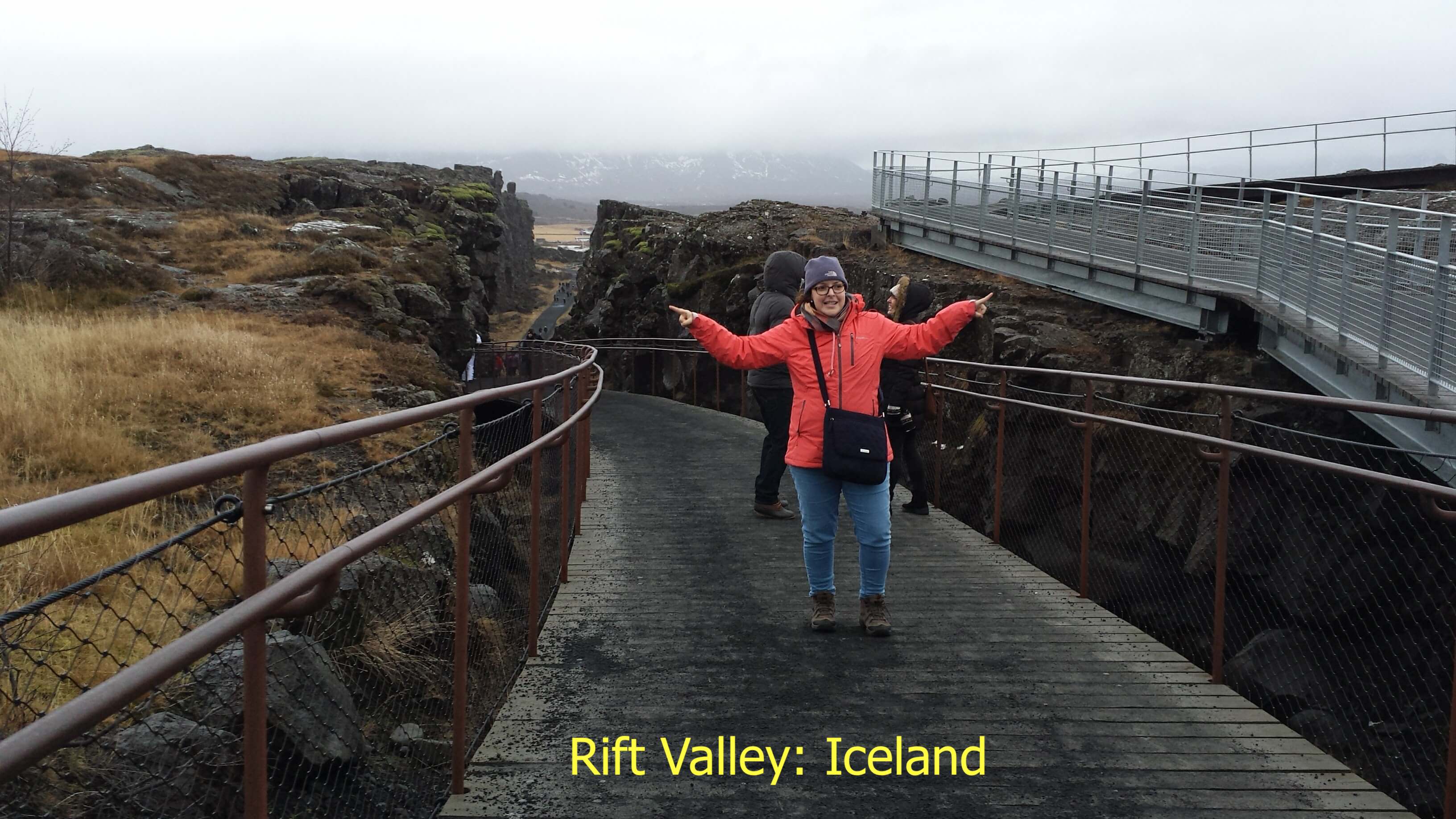
Plate Tectonics
Different theories explain Plate Tectonics. That is the motion of plates relative to each other. On average, plates move 1 to 6 inches (2 to 15cm) per year.
This interaction has caused formations like the San Andreas Fault in California or the Himalayas mountain range in Asia.
One theory suggests that the convection of the Asthenosphere and Lithosphere move the plates at different rates. National Geographic.
This convection theory is currently out of favor. Recent imaging techniques are unable to spot mantle convection cells large enough to move plates. Some models show the surface moving faster than the mantle!
The current theory is known as "slab pull". It states that the new Lithosphere is less dense than the Asthenosphere. As it ages, it gets cooler and denser. This causes it to sink at subduction zones, pulling slabs of the lithosphere apart and creating rifts. Source: Geological Society.
The movement of plates is not new. Throughout the Earth's history, they have been moving and shifting. Their positions have created a supercontinent like Pangea or landmasses like Laurasia and Gondwana.
For a more indepth read about this topic, Amazon has Plate Tectonics (Great Discoveries in Science). Readers will look at theories put forward through the ages to explain volcanoes and earthquakes, and they'll examine how geologists learned what we now understand about Earth's crust.
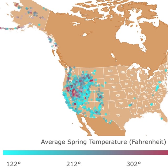
Interested in experiencing Geology and not studying it? Look at this map of Hot Springs in the U.S.
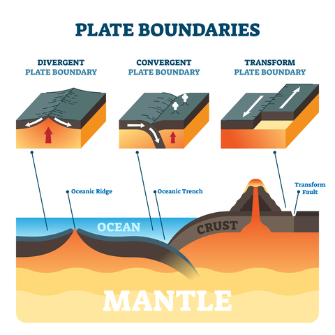
Plate Boundaries
The edge where Tectonic Plates meet is called the plate boundary. Along these boundaries, you will find most of the mountain ranges, earthquakes, volcanic activity, and Ocean Trenches.
Because of Plate Tectonics, Plate Boundaries may be classified into three different types: Convergent, Divergent, and Transform.
Convergent Boundaries
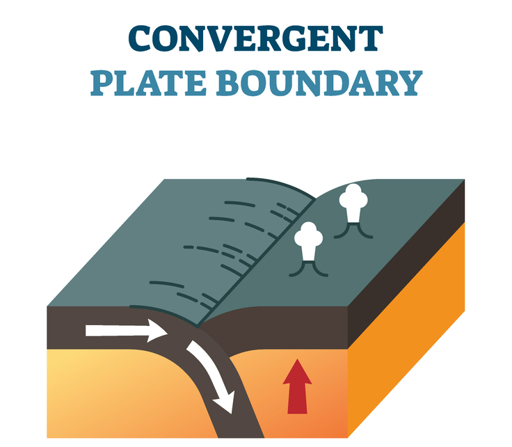
Convergent Boundary is where two plates collide.
Continental Convergent Boundary
Where two continental plates collide. Usually, when they collide, they smash together. This convergence will likely form mountains.
The crust is too thick for magma to get through, so there are no volcanoes formed.
An example of a Continental Convergent Boundary is the Himalayas by the collision of the Indian Plate with the Eurasian Plate.
Oceanic Convergent Boundary
The older, denser slabs of the oceanic crust will plunge beneath the less dense oceanic crust. This convergence will form volcanoes. Source: RWU.
Japan, the Aleutian Islands, the Caribbean islands of Martinique, St. Lucia, and St. Vincent are examples of islands formed through this type of plate boundary.
Subduction Zones
Where older, denser oceanic lithosphere sinks under a continental mass and is melted into the mantle. Subduction zones are likely to form trenches and form volcanoes.
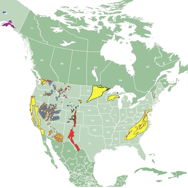
Map of Gold Deposits in the USA
Divergent Boundaries
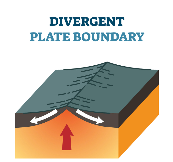
Where two plates move apart, creating or producing new crust and lithosphere. These are most common under the ocean.
Continental Rift Boundary
These are Divergent Boundaries that occur on the continental lithosphere; as the rigid lithosphere thins and warms, rifts and rift valleys form. These rifts are likely to produce new oceans.
A well-known Continental Rift is the East African Rift between the African and Somalian plates over a large area of Africa. FSU.
Oceanic Spreading Ridge
This type of Divergent Boundary occurs on the ocean floor. These are fracture zones where new crust is created by molten mantle material that comes to the surface.
These fractures are visible on the ocean floor as a line ridge formed of molten rock that rises and solidifies. As this molten rock reaches the sea bottom, it produces volcanic eruptions of basalt.
The speed at which the ridges spread affects the ridge shape. Slow-spreading ridges are irregular and steep. Fast-spreading ones are wider and have gentler slopes.
The mid-Atlantic ridge is a well-known slow-spreading ridge. NOAA
Transform Boundaries
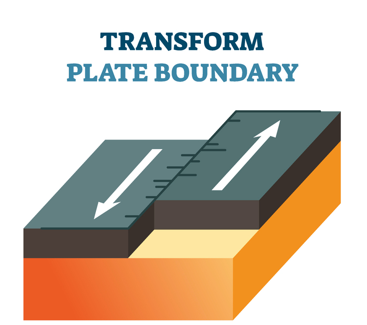
Transform Boundaries exist where plates slide past each other. These are also called "Conservative" Plate Boundaries, as plate material is not created or destroyed.
They play a key role in plate tectonics as they allow connections between ridges and trenches by accommodating lateral movement.
Their study is also essential because these boundaries can produce high-magnitude earthquakes and trigger tsunamis.
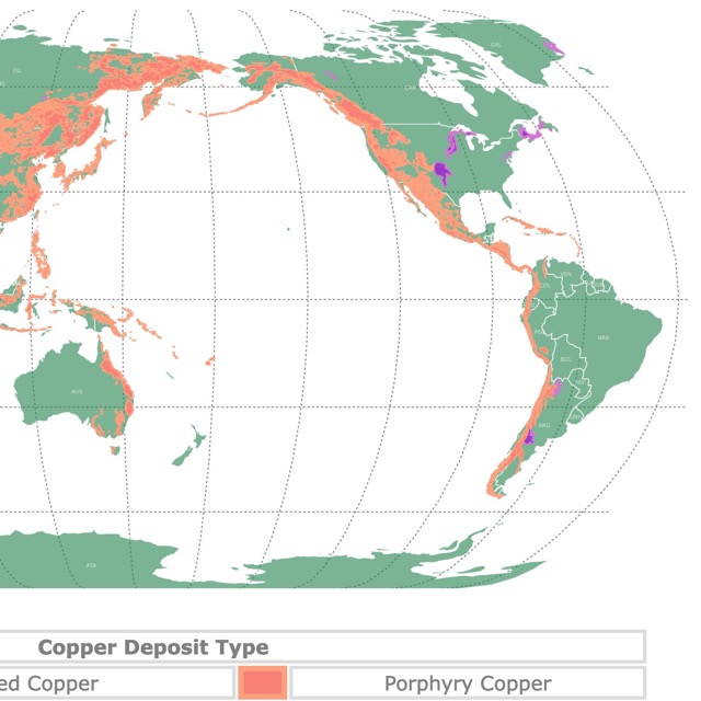
World Map of Copper Mineral Sources and Geology
Continental Transform Fault
These Transform Faults occur between the margins of the continental crust.
A well-known example is the San Andreas Transform Fault in California.
Oceanic Transform Fault
These are mainly linked to plate growth, as they accommodate horizontal movements of mid-ocean ridges.
They have a particular structure of narrow valleys and steep walls reaching 6,561 feet (2,000m). These scars the ocean floor miles beyond the active plate boundary. The scars are called fracture zones. Frontiers in Earth Science
Orogens
Orogens are ancient folded mountain belts. Orogenenesis is the process that leads to their formation. These commonly occur when two plates converge. U. Alberta.
Map of Gold Deposits Worldwide
Thank you for Subscribing!
Follow Me
Resources for Tectonic Plates and Boundaries
The information on which this map is based comes from the article An updated digital model of plate boundaries by Peter Bird.
The tectonic plates and boundary shapefiles to create this map were downloaded from GitHub.
The Shapefiles for the continents were downloaded from Natural Earth.