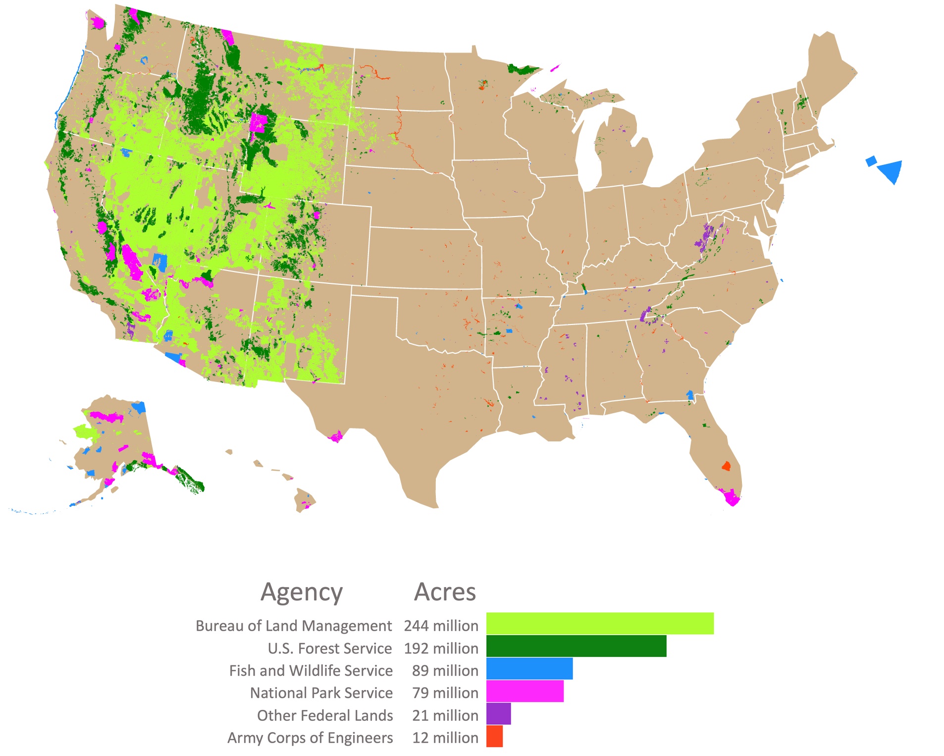
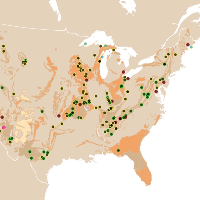
U.S. Public Lands Map
This interactive map shows the Locations, Names, Area, and Uses of designated Public Lands managed by United States agencies. Each polygon represents a unit. The color of each unit represents a manager agency. For more detail zoom in. For more information hover over the map, or scroll down.

U.S. Public Lands Map
This map shows the locations of designated protected Public Lands. Each color represents a different agency. The size of land ownership, is depicted in a horizontal bar graph, as the key. As shown not all agencies control the same amount of land.
The federal government owns around 640 million acres, of 2.27 billion acres of land in the United States. This corresponds to 28% of all US land.
There are some blank areas or squares quite prominent in the west that are not part of the public lands. Some of them are part of the Department of Defense. Others like the one in the middle of Wyoming, belong to the Bureau of Indian Affairs.
This map is mainly concerned with lands that may be used for public recreation and conservation. Therefore, lands from the Bureau of Indian Affairs and Department of Defense are not included.
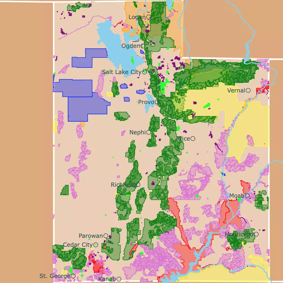
Every state has different percentages of Public Lands. Utah is a great example of large areas dedicated to public lands and parks. For more information check this map of Utah's Parks and public lands.
Public Lands Facts
- Nevada has the most federally owned land with 80.1%, of the whole state
- Iowa and Connecticut have the least amount of federally owned land with 0.3%, of the whole state
- Federal land is concentrated in Western States
- The state with the most federal land overall is Alaska, with 222,665,580 acres which accounts to 60.9% of the state
The major agencies that manage federal lands included in this map are described below:
Affiliate Disclosure
Databayou.com is a participant in the Amazon Services LLC Associates Program, an affiliate advertising program designed to provide a means for sites to earn advertising fees by advertising and linking to Amazon.com. Databayou.com also participates in affiliate programs with Clickbank, CJ, and other sites.
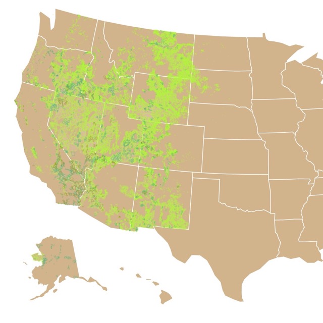
Bureau of Land Management
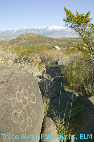
The Bureau of Land Management (BLM) manages and conserves public lands, primarily in twelve western states and Alaska, for the use and enjoyment of present and future generations.
The BLM has different uses and purposes for the land, including recreation, conservation, and development of Natural Resources such as mining.
The Bureau of Land Management manages 244.4 million acres, 10.5% of the US, more than any other agency!
The Bureau of Land Management is administered by the Department of Interior.
Public Lands are great places for hiking and camping off the grid. For an adventure outdoors in mild conditions and for a small family, I recommend this tent found on Amazon Coleman 6-Person Dark Room Sundome Tent. It is not expensive and it will protect you from the elements.
Want to learn more about Public Lands? Check this Bureau of Land Management Map.
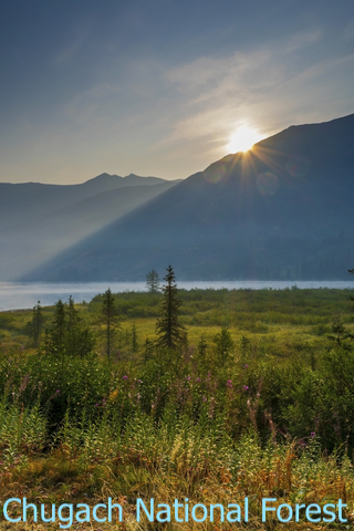
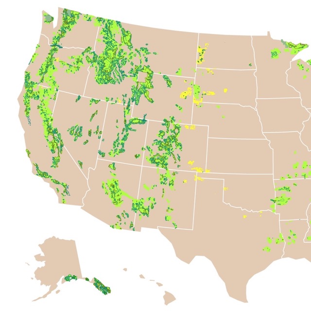
U.S. Forest Service

The United States Forest Service USFS, emphasizes Sustainable Forest Management, National Forest Roads, Recreation, Watershed health and restauration.
Like the BLM the USFS has different uses and purposes for the land, including recreation, conservation, grazing, and lumber.
It is important to clarify that ecosystem management, is the driving force behind current policy of the Forest Service.
The U.S. Forest Service (FS) manages 192.9 million acres, 8.5% of the United States.
The U.S Forest Service is part of the United States Department of Agriculture.
If you are interested in learning more about the National Forests you can buy one of these three part guide book found on Amazon. It is the most comprehensive field guide with descriptions of the natural features, wildernesses, scenic drives, campgrounds, and hiking trails of our national forests: This Land: A Guide to Western National Forests.
Want a more details about the Forest Service? Check this map.
Fish and Wildlife Service

The Fish and Wildlife Service (FWS) is the government agency dedicated to the conservation, protection, and enhancement of fish, wildlife, plants, and their habitats.
Among other responsibilities the FWS protects and recovers threatened and endangered species, monitors and manages migratory birds, and restores nationally significant fisheries. It also enforces federal wildlife laws, regulate international wildlife trade, conserve and restore fish and wildlife habitat such as wetlands. Source: FWS.gov
If you are planning to visit one of FWS sites, I would suggest you take this binoculars found on Amazon: Gosky 10x42 Roof Prism Binoculars for Adults, HD Professional Binoculars for Bird Watching Travel. They will help you see the best of wildlife, while standing at a safe distance.
The Fish and Wildlife Service has 89.2 million acres of land, which corresponds to 3.9% of U.S. lands.
The FWS is managed by the U.S. Department of Agriculture.
National Park Service
National Parks are the crown jewels of all our Public Lands. The National Park Service (NPS) main goal is: to preserve "the natural and cultural resources and values of the National Park System for the enjoyment, education, and inspiration of this and future generations". Source: NPS.gov.
National parks are designated for their natural beauty, diverse ecosystems, recreational opportunities, or unique geological features.
California has the most National Parks, with nine, followed by Alaska with eight.
The National Park Service (NPS) manages 79.9 million acres with 59 National Parks and 426 different sites available for the public. That is 3.7% of U.S. land.
National Parks are created by Congress, the legislative branch of the government.
The Department of Interior is in charge of managing the National Park Service, source: Federal Land Ownership.
If you would like to read more about the National Parks, this book highlights the extraordinary features that distinguish each park. It has stories and impressive pictures about these incredible landmarks. Here is the link from Amazon: National Geographic Atlas of the National Parks.
Interested in Natural Areas? Check this map of National Parks
Department of Defense
There is a fifth agency not included in this map which is the Department of Defense (DOD). They administer 8.8 million acres. These land is used for military bases, training, and ranges. These lands are not depicted in this map, as they are not accessible for the general public to use.
Army Corps of Engineers

There is one more agency that is part of the Department of Defense and is included in this map. That is the U.S. Army Corps of Engineers (ACE). The Army Corps of Engineers builds and maintains America’s infrastructure. The ACE also dredges America’s waterways to support the movement of commodities and provide recreation opportunities at campgrounds, lakes, and marinas.
The ACE is one of the nation's main providers of outdoor recreation, with more than 400 lake, and river projects in 43 states. If you have used an area close to water you have probably used one of their sites. This is the main reason why it was included in this map.
The Army Corps of Engineers is responsible for 12 million acres of public lands and waters nationwide. ACE
For an excursion in some of these waterways, I suggest you take this inflatable boat from Amazon. The Intex Seahawk 3 Person Inflatable Boat, can be used for relaxing, exploring, or fishing with friends and family.
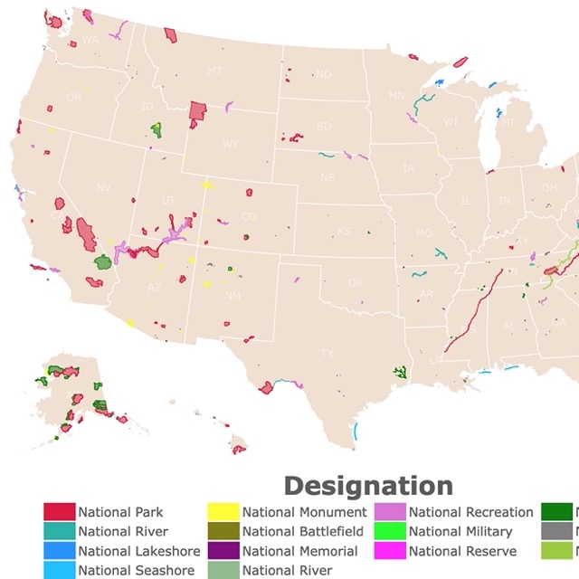
Land Designations Span Agencies
While making the different Public Lands Maps, I noticed that National Monuments came up as different designations. It took me a while to realize that they can apply to multiple agencies.
Public Lands have different titles of designations depending on factors like cultural, historical, recreational, conservational, or scenic value.
To see which type of designation is a public land, you can hover over the map and look for "Designation Type".
These designations that span agencies include National Wild and Scenic Rivers System, the National Trail System, the National Monuments, Wilderness Areas, and National Recreation Area.
In case you want to find an RV park, this map of RV campgrounds might help you.
National Monuments
National monuments are nationally significant land and waters saved for permanent protection. They may also contain statues or buildings but this is not necessary.
They are frequently chosen for their historical or archaeological significance.
Unlike National Parks, National Monuments are created by presidents, through the Antiquities Act. Therefore, National Monuments are created by the executive branch.
Sometimes a National Monument is created by the president and then Congress will amend the designation to a National Park. NPCA
National Monuments can be managed by either USNF, NPS, FWS, or the BLM or a mix of them.
National Monuments managed by NPS have more restrictions than other agencies.
This is a list of the most visited natural National Monuments, source: IRMA Portal.
- Muir Woods, California: Part of the Golden Gate Recreational area, protects the Coast redwood (Sequoia sempervirens).
- Cedar Breaks, Utah: Canyon naturally shaped like an amphitheater.
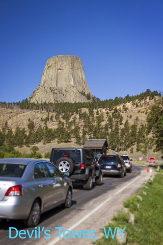
- Devil's Tower, Wyoming: Devils Tower (also known as Bear Lodge Butte) is a butte, composed of igneous rock, standing 867 feet (265 m) from summit to base.
- Canyon de Chelly, Arizona: It consists of canyons, valleys, and rims.
- Colorado, Colorado: Is a semi-desertic canyon.
Some National Monuments require extensive hikes. In such situations I would suggest Merrell Moab 2 Vent Hiking Shoes. They have a breathable mesh, that will keep your feet comfortable.
Want to learn about other geologic features in the US? Check this map about Caves!
Wilderness Areas
Wilderness is the most protected land designation. They can also exist under USNF, NPS, FWS, or BLM.
The wilderness Act passed in 1964 and 9.1 million acres were assigned as wilderness. In 1984, 56 million acres in Alaska were included. This was the year when most new wilderness areas were added.
Only 5% of the USA is protected as wilderness. Source: https://wilderness.net/
There are also wilderness study areas. These are areas that the agencies have identified as having wilderness characteristics that may qualify them for wilderness designation.
When these lands have been found suitable, they are designated by Congress. Source: Bikepacking.com
Many of these areas are open for skiing. To learn more check this map of Ski Resorts in North America
National Recreation Area
There are 40 protected areas designated as National Recreational Areas (NRA) in the United States. They are also established by Congress.
Their purpose is to provide enhanced recreational opportunities, in places with significant natural and scenic resources.
Some of the activities provided to visitors are camping, hiking, fishing, swimming, boating, biking, and wildlife viewing.
NRAs are managed by the National Park Service (NPS), the United States Forest Service (USFS), and the Bureau of Land Management (BLM).
The most visited natural Recreation Areas according to IRMA Portal are:
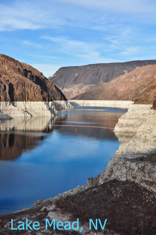
- Lake Mead, Nevada and Arizona: Surrounded by deserts, and incredible rock features, close to Hoover Dam.
- Glen Canyon: Utah and Arizona: River erosion created sandstone formations and canyons.
- Chattahoochee River: Great for hiking and boat trips.
- Delaware Water Gap, New Jersey and Pennsylvania: This is a reservoir surrounded by a natural area.
- Chickasaw, Oklahoma: Mineral Springs with waterfalls and trails.
Sometimes it is overwhelming to see all that beauty and wildlife without knowing their names. In those cases it is ideal to carry a book like this one found on Amazon: (National Geographic Illustrated Guide to Wildlife. It includes North America's most common birds, mammals, insects, reptiles, and amphibians, plus fish, and other aquatic creatures.
Want to relax in a hot spring while at a park? Check this map of US hot springs
Passes and Visits to Public Lands

America the Beautiful Pass will give you access to more than 2,000 federal recreation sites. Basically any federal lands that charge an access fee. These include National Parks, Fish and Wildlife Refuge, Bureau of Reclamation, U.S. Army Corps of Engineers, Forest Service, and Bureau of Land Management.
Currently the annual pass is $80 dollars but is free for seniors, military, and fourth graders. NPS.gov.
Some National Parks also offer a pass for their park only as an annual pass.
Remember these are only good at federal parks, and not state parks....which have their own type of passes.
Some popular sites may need a reservation before hand, even if you have the annual pass.
If you plan to camp or stay the night go to Reserve America. This will be your best way of finding a campground.
Public Lands Map Resources
The shapefiles for this map were downloaded from USGS. The shapefiles for the states was downloaded from Natural Earth.
You like this map? To receive updates on this and more nature maps, join my email list!!!!!!!
Made by Luz K. Molina with D3.js.