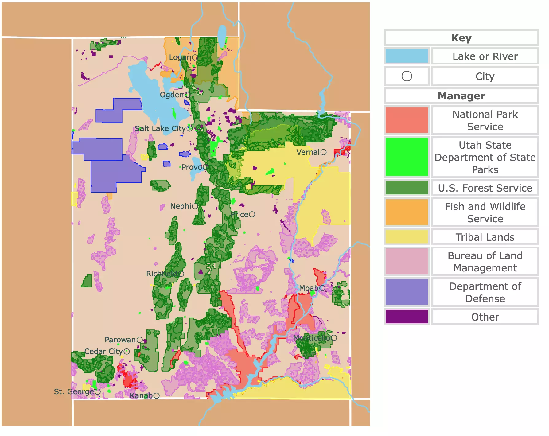
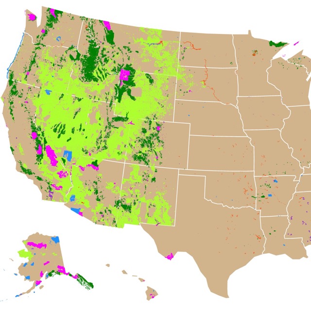
Map of Utah's Parks and Natural Areas
This interactive map shows the Locations, Names, Areas, and Details of National Parks, State Parks, National Forests, Tribal, and other Public Lands of Utah. It also shows major cities and rivers for context. For more detail, zoom in. For more information, hover over the map, or scroll down.
| Key | |
|---|---|
| Lake or River | |
| ◯ | City |
| Manager | |
| National Park Service | |
| Utah State Department of State Parks | |
| U.S. Forest Service | |
| Fish and Wildlife Service | |
| Tribal Lands | |
| Bureau of Land Management | |
| Department of Defense | |
| Other | |
Utah's Geography
Utah is a traveler's paradise. The state has Deserts, Canyons, Alpine Landscapes, and incredible Rock Formations. These features are the result of the state's geologic history.
Utah has three geographic areas. To the west is the Central Basin and Range, to the east is the Colorado Plateau, and in the middle of these are the Rocky Mountains.
The Rocky Mountains go from north to south of the state. They include Utah's highest point, King's Peak, at 13,528ft (4,123m).
The Rocky Mountains also happen to be mainly designated as National Forests and are the green streaks on the map above.
The Colorado Plateau is not very flat. It has mountains, canyons, and valleys. The Plateau is where most of Utah's National Parks are located.
The Basin and Range include mountains, salt flats, and the Great Salt Lake. Source: National Geographic.
Utah has 5 National Parks, 7 National Monuments, 50 State Parks, and 6 National Forests, all depicted on the map above.
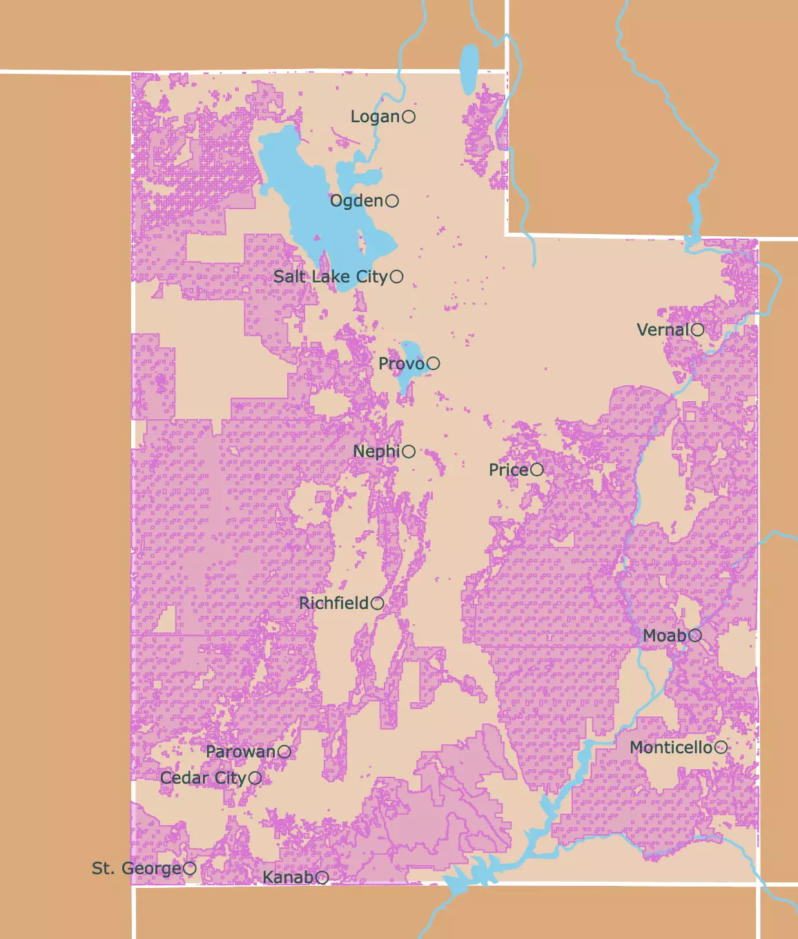
Most of the state is managed by the Bureau of Land Management. These areas are represented in pink on the map to the right. The small squares spread throughout belong to the state.
Because this agency oversees so much of the state and is so overwhelming, I decided to make a map exclusively with the Bureau of Land Management.
The map above includes all agencies and only a few sites from the Bureau of Land Management.
If you are interested in detailed maps of Utah, Amazon has the book for you. The Utah Road and Recreation Atlas is designed to help locals and visitors make the most of the attractions that Utah has to offer. It has recreation sites, fishing spots, and hunting areas, as well as a myriad of parks, natural wonders, and historic sites dotted across the state.
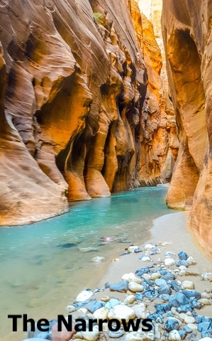
Interactive Map of Zion National park, its trails and points of interest
Utah's Wildlife
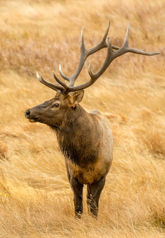
Common animals found in Utah include Rocky Mountain elk (the state animal), desert bighorn sheep, mountain lions, chipmunks, squirrels, jackrabbits, red-tailed hawks, golden eagles, kingsnakes, lizards, and the desert tortoise.
Frequent trees and vegetation include the Utah Juniper, the quaking aspen, pinyon pines, Joshua trees, canyon maple, sego lily (the state flower), honeysuckle, woodland-star, and serviceberry.
Facts about Utah
- The Southwest corner of the state touches Arizona, New Mexico, and Colorado. It is the only place in the country where this happens. Because of it, the site is called "Four Corners".
- Known as the Beehive State, but not because of its bees. When Brigham Young and the Latter-day Saints arrived in Salt Lake Valley, he chose the beehive as a symbol of cooperative work and perseverance.
- The State of Utah claims to have the best snow. This is because Utah's snow is light and dry.
- The Great Salt Lake is saltier than the ocean. The lake has no outlet, so the water flows in and then evaporates, leaving behind dissolved salts and minerals.
- Copper is the state mineral, and Utah has one of the world's largest open-pit copper mines.
- Lake Powel, located between Arizona and Utah, is the second-largest artificial lake. It has natural canyons and Rainbow bridge, one of the world's largest natural bridges.
- The city of Moab is near Canyonlands and Arches National Parks. It is the ideal place to begin the journey to these national parks. Moab is also great for biking, whitewater rafting, climbing, and hiking.
- Parkcity has 3 well-renowned ski resorts: Deer Valley Resort, Canyons Resort, and Park city mountain resort. They are perfect for snowboarding and skiing.
- Parkcity is also famous for hosting the Sundance Film festival, nearby Springs, and hiking trails.
- Salt Lake City is home to the Mormon church.
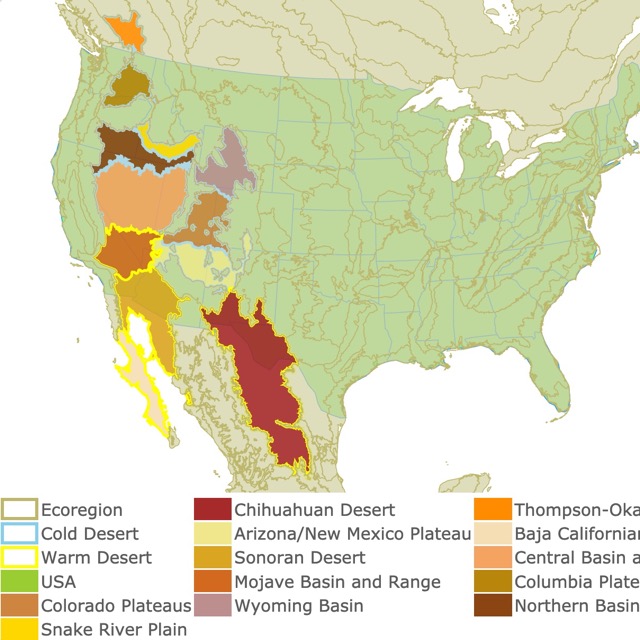
In case you want to learn more about deserts in the U.S., check out this map!
Utah Parks and Natural Areas You Cannot Miss
With so many National Parks, National Forests, and Monuments, it is hard to choose where to start. There is a park or feature to fulfill anyone's taste.
In fact, Utah is home to 5 of the best national parks. Arches, Bryce Canyon, Capitol Reef, and Zion. These are known collectively as the Mighty Five.
If you want to read more about the Mighty Five, Amazon has the Moon Utah: With Zion, Bryce Canyon, Arches, Capitol Reef & Canyonlands National Parks. This Travel Guide has strategic itineraries, must-see highlights, and unique experiences.
Zion National Park is so impressive it deserves its own map. For details on this amazing map, you can find it here!
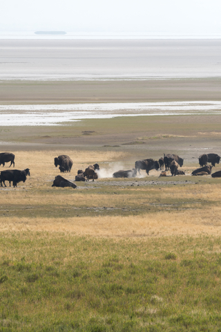
Antelope Island State Park
Antelope Island State Park is an Island located in the southern part of the Great Salt Lake, situated north of the state. It is depicted in lime green on the map.
Antelope Island is well known for its wildlife. It is home to free-ranging bison, mule deer, bighorn sheep, pronghorn, and millions of water birds, among other organisms.
Fun things to do on the island include viewing the balloon festival, cycling, horseback riding, kayaking, stargazing, and hiking, all surrounded by spectacular scenery. Source: Antelope Island.
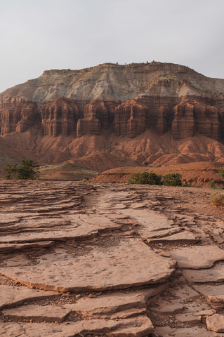
Capitol Reef National Park
Capitol Reef National Park is in the Southcentral area of Utah.
The park is a long and narrow form, colored in light red on the map. It is about 100 miles (160Km) long.
Capitol Reef has buttes, monoliths, canyons, cliffs, ridges, domes, and bridges.
The park is named after the white domes, like those in the capitol buildings, and by the rocky cliffs that form barriers.
The park's geologic history can be summarized in three steps that took millions of years in the making: deposition, uplifting, and erosion. The deposition comes from a range of different environments that left a mark.
The area was uplifted millions of years ago. This resulted in the rock layers on the west side of the fold lifting more than 7,000 feet (2,134 m) higher than the layers on the east. Erosion uncovered some forms and rocks.
The park has springs, water pockets, streams, perennial waterways, fossils, and basalt boulders.
Capitol Reef has more than 250 species of birds, amphibians, fish, and reptiles, plus bats, deer, coyotes, and cougars.
This park is less crowded than other nearby national parks, but very scenic. Source: Capitol Reef.
Want to find places to explore in nearby Nevada? Check this map of Nevada Parks
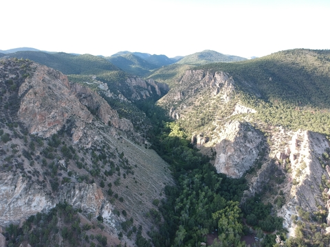
Canyonlands National Park
Canyonlands is situated just southwest of Moab; it is also represented in red on the map.
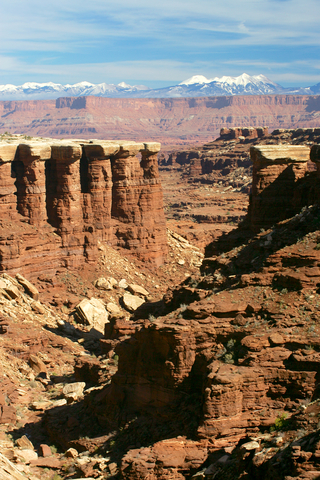
Canyonlands is the largest National Park in Utah. It is a colorful park full of canyons, buttes, and mesa. Even in Utah, it is quite special.
The park is divided by the Colorado River and Green River into four districts with a distinctive characters:
- The starting point to discover this park is Island in the Sky. This is a 1,500-foot (457m) mesa, from which you can observe and pull out to see the incredible vistas. This is also a good location to hike.
- The Needles are dominated by colored spires of Cedar Mesa Sandstone that dominate the landscape.
- The Maze is the least accessible area. Exploring this area may take several days.
- The Colorado and Green rivers separate the three districts mentioned before, as they cut through the layered sandstone, creating a sharp contrast with the rocky desert.
The park also has Horsehoe Canyon, which has well-preserved rock art with intricate designs. Source: Canyonlands.
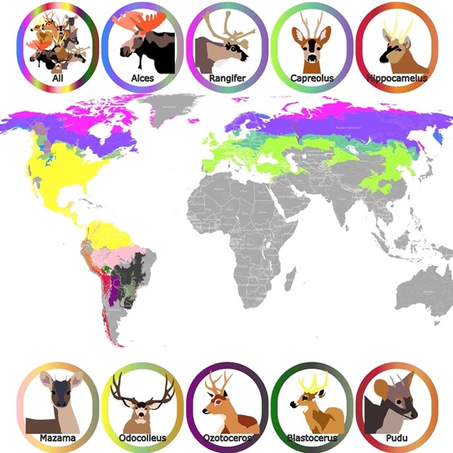
If you want to learn more about the deer present in Utah, check this map of the Deer Geographic Range
Arches National Park
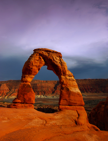
Arches National Park is just north of Moab and is one of the top National Parks in the U.S.
Arches National Park has more than 2,000 arches, the largest proliferation of arches in the world. You have probably seen its most famous arch, called Delicate Arch. Delicate Arch is displayed in different National Parks and Utah brochures; it is a state icon.
Arches National Park is also famous for its balancing rocks, spires, and rock fins.
About 65 million years ago, this area was a dry seabed. Different geologic forces wrinkled the land. Later, erosion carved the rock, exposing layers of rock.
This is a great place for hiking, taking photographs, climbing, biking, and stargazing. Just remember it is also a very popular park. You might want to come early or avoid the summer crowds. Source: Arches National Park.
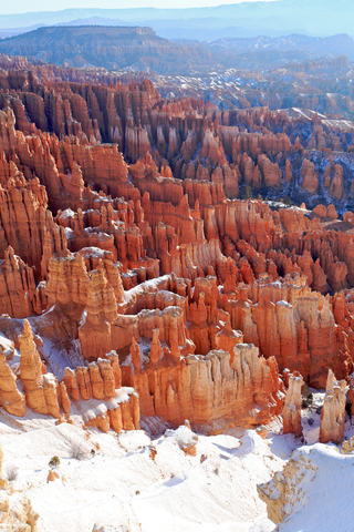
Bryce Canyon National Park
Bryce Canyon is located in southwestern Utah. It is in light red on the map above.
Bryce is more of a natural amphitheater than a canyon. Vistas of colored rock and Hoodoos are the main attraction.
Visitors enjoy exploring the "Hoodoos" or irregular columns of rock. Hoodoos are created by insidious erosion. This is a destructive process in which the water freezes and expands inside rock cracks.
You can bike, horseback ride, hike or ski through its incredible trails.
This is another popular tourist destination, so plan your visit before you go. Source: Bryce Canyon.
Interested in Public Lands? Here is a link to a map of U.S. Public Lands
Fishlake National Forest
Fishlake National Forest is located in central Utah. It is colored green on the map above.
Fishlake National Forest has a 5-mile (8Km) long, 128-foot (39m) deep water body with mackinaw trout. The lake offers great opportunities for fishing and bird-watching.
The forest has aspen trees encircling the open mountain meadows.
The forest wildlife includes moose, blue herons, mountain goats, black bears, elks, deer, cougars, and wild turkeys.
The park has a cluster of 4,000 aspen trees. Nevertheless, these trees share the same root system, which emerged from one seed! This large single organism is called Pando, it spans 106 acres and it may be the most massive known living organism on Earth. Source: Forest Service.
Bonneville Salt Flats Special Recreation Management Area
Bonneville Salt Flats is located Northwest of the state. It is colored pink on the map as it is managed by the Bureau of Land Management.
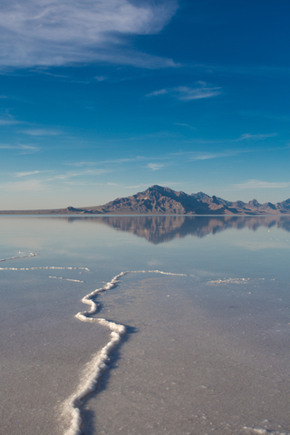
Bonneville is so flat you can see the curvature of the Earth. The area is so barren that not even the simplest life forms can exist there.
The Salt Flats were formed when ancient Lake Bonneville dried up. Its water evaporated, and salt deposits were left behind. Utah.com
The salt flats are an expanse of land with hard, white salt crust on the western side of the Great Salt Lake basin in Utah.
The salt flats are 12 miles (19Km) long and 5 miles (8Km) wide.
Motor vehicle use is limited during the spring months because the salt is moist, and there might be standing water on the surface.
It is estimated that the crust is 147 million tons of salt, 90% of which is common table salt! Salt Flats.
Some visitors to Bonneville have used the potash canals for paddling. These canals are on public land but were carved to extract minerals and salts from the brines.
Potash is a salt used for fertilizers. Unfortunately, despite the blue color of the water, authorities say it is not safe for paddling or swimming. Source: Salt Lake Tribune.
Wondering which of these parks is the best one for stargazing? Check out this Dark Skies Map site!
Grand Staircase-Escalante National Monument (GSNM)
GSNM is managed by the Bureau of Land Management. The monument is located in the south of the state, and it is colored pink on the map above.
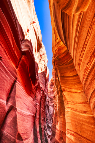
GSNM has giant curves that look like waves. It also has slot canyons, monoliths, natural ridges, and arches.
This area is so remote it was one of the last areas of the U.S. to be mapped.
Due to its size and location, the monument spans five zones, from low-lying deserts to coniferous forests.
Its resources and features are a playground for archeologists, biologists, geologists, and paleontologists. Source: Grand Staircase_Escalante National Monument.
Follow Me
Resources for Utah Parks Map
The shapefiles with Utah's state boundary lines, major rivers, and cities were downloaded from Natural Earth Data.
The Parks and Public Lands shapefiles for Utah were downloaded from USGS.
This map will be updated with new data! To receive updates on this and more nature maps, join my email list!!!!!!!
Made by Luz K. Molina with D3.js.