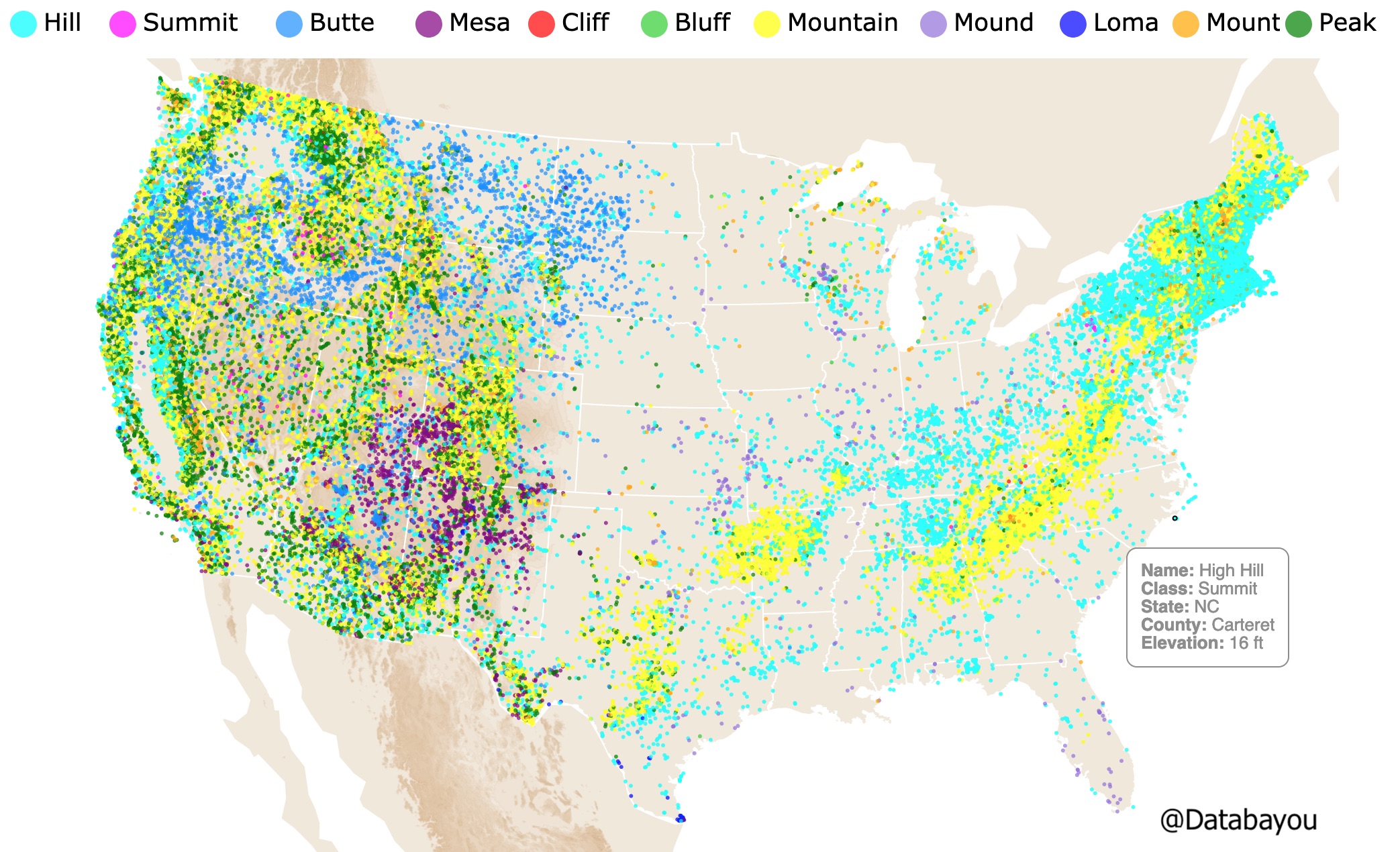
Hill or Mountain? Summit or Peak?
This map will show you different land formations and their names. If you hover over the map you will also see the State, County, and Elevation.
Different colors were used to highlight the different geographic locations of these formations.
Mountain
A natural elevation of the earth's surface. Attaining an altitude greater than that of a hill, usually greater than 2,000f (610m) Dictionary.com.
Mountains usually have steep, sloping sides and sharp or rounded ridges, and a high point, called a peak or summit.
Mountains are usually named.
Geologists classify a mountain as a landform that rises at least 1,000 feet (300 meters) or more above its surrounding area
A mountain range is a series or chain of mountains that are close together. Examples of mountain ranges are the Himalayas, the Andes, and the Rockies.
Mountains are formed when plates from the Earth's crust, encounter each other, in a process called Plate Tectonics, and wrinkle up like the hood of a car in a head-on collision.
Mountains often serve as geographic features that define natural borders of countries.
Their height and shape can influence weather patterns, holding storms that roll off the oceans and keeping water from the clouds. When this happens, the other side is usually drier National Geographic.
Features are not only punctual. Some form beautiful shapes worth exploring
Mount
According to the Merriam-Webster dictionary, a Mount is a high hill. Mount is used especially before an identifying name.
Hill
In general hills have a lower elevation than a mountain and a more rounded shape than a distinct peak.
Hills are a bump in the landscape, rising gradually from its surroundings.
They are less than 2000(609m) feet high, and are often unnamed.
Hills have a rounded top, easy to climb, with not a well defined summit. Source: ThoughtCo.
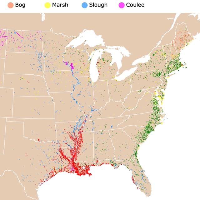
This map shows you where Swamps and Bayous are found through out the US
Butte
A Butte is a conspicuous isolated hill with steep, often vertical sides and a small, relatively flat top. It comes from French meaning small hill.
Not to be confused with Mesas or Plateaus, which are typically have the top surface larger than their vertical faces. Buttes are taller than they are wide.
Buttes are amazing natural formation found by the Spanish in the 16th century North of Mexico. Universe Today.
Mesa
Some simply define a Mesa as a landform that is wider than it is high.
These land formations where named by the Spanish explorers. They gave them such names because they resemble tables with their smooth, flat tops and steep drops on the side. Source: http://www.scienceclarified.com/landforms/Faults-to-Mountains/Mesa-and-Butte.html
A mesa is an isolated, flat-topped hill or mountain with steep sides that is smaller in area than a plateau.
Some have tried to classified it by a specific size but this changes according to the author. One value given is that a Mesa has a surface area larger than 1 square mile (2.59 square kilometers) and Buttes have a smaller surface area than this.
A mesa's and butte's characteristic shape—flat top and clifflike sides—is due to the layers of rock forming them. These landforms are most often composed of sedimentary rock, formed by the accumulation and compression of sediment.
Buttes and Mesas are found in semi arid regions with 10-20 inches of rain per year.
If classified by area size: Plateaus > Mesa > Butte.

This map shows you where Lakes, Ponds, and Lagoons are located.
Cliff
In geography and geology, a Cliff is a vertical, or nearly vertical, rock exposure.
Cliffs are formed as erosion landforms by the processes of weathering and erosion. Cliffs are usually formed by rock that is resistant to weathering and erosion.
Cliffs are common on coasts, in mountainous areas, escarpments and along rivers Wikipedia.
Bluff
A bluff is defined as a steep shoreline slope formed in sediment (loose material such as clay, sand, and gravel) that has three feet or more of vertical elevation just above the high tide line.
A bluff is a cliff created by water erosion. It can form along rivers, some large lakes or seas, or along the ocean shore.
Cliffs or slopes in bedrock (ledge) surfaces are not bluffs and are not subject to significant erosion in a century or more. Beaches and dunes do not form bluffs, except along the seaward dune edge as a result of erosion. Source: Maine.gov
Loma
A hill or ridge having a broad top.
Summit
So what is a summit? A summit is the highest point on a mountain. Every mountain has a summit, no matter what the mountain is. This means it is the highest elevation among all points immediately close to it. SSC.
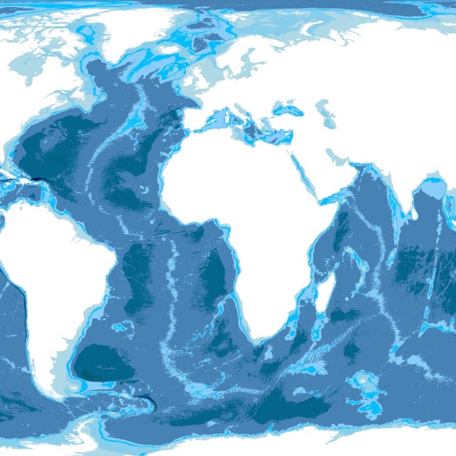
This is a Bathymetry map. It shows underwater depth. For more information check it out!
Peak
The pointed top of a mountain.
The topographic terms acme, apex, peak (mountain peak), and zenith are synonymous.
Inspiration for Hills, and Mountains Map
This map is a follow up to Wetlands of the US. The data provided the names of different features of the US. I then created Lakes and Ponds of the US. Nevertheless, the data also provided physical features like summits. This map includes features that are not only classified as summits such as cliffs. The names included were those classified as synonyms of summit.
Made by Luz K. Molina with D3.js.
FOLLOW ME
Resources to Make this Map
The data was downloaded from the Geographic Names Information System (GNIS), maintained by USGS. Data cleaning was done with R Project for Statistical Computing. At first I used only the data classified as summits, but then added other features like cliffs. The Shapefiles for political borders in this map were downloaded from Natural Earth. The elevation shapefiles were downloaded from USGS Science Base Science Catalogue. The code was obtained and altered from Chris Williams’s Bl.ock.