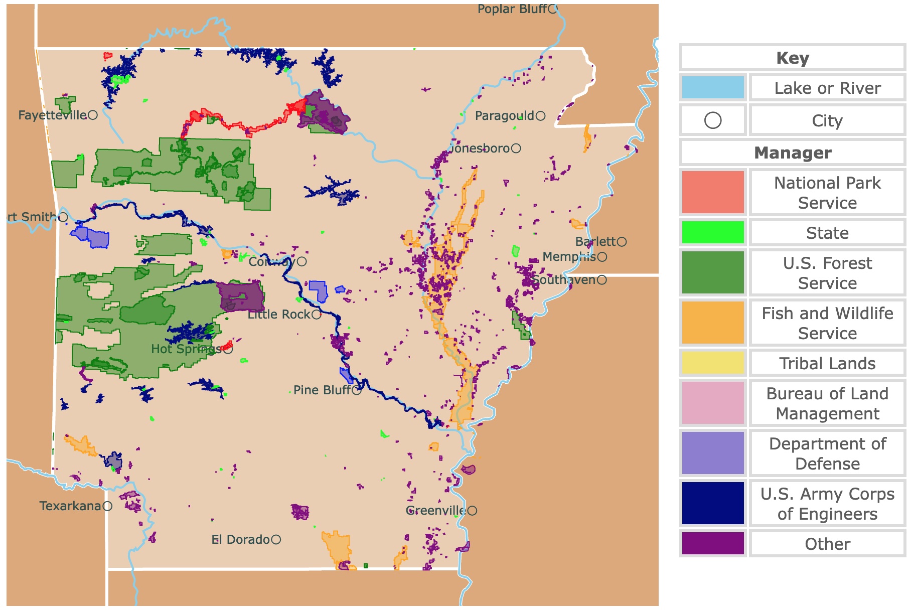
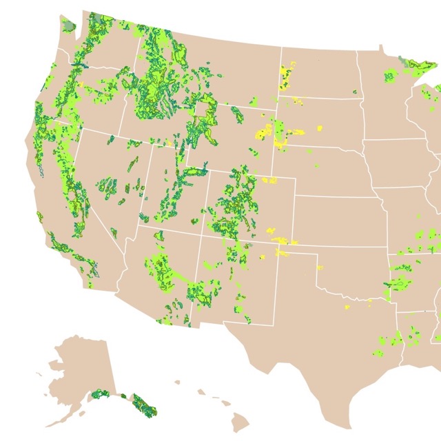
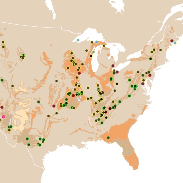
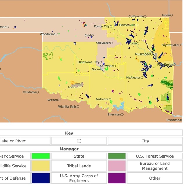
Map of Arkansas's Protected Areas
This interactive map shows the Locations, Names, Areas, and Details of National Parks, State Parks, National Forests, Tribal, and other Public Lands of Arkansas. It also shows major cities and rivers for context. For more detail, zoom in. For more information, hover over the map, or scroll down.
| Key | |
|---|---|
| Lake or River | |
| ◯ | City |
| Manager | |
| National Park Service | |
| State | |
| U.S. Forest Service | |
| Fish and Wildlife Service | |
| Tribal Lands | |
| Bureau of Land Management | |
| Department of Defense | |
| U.S. Army Corps of Engineers | |
| Other | |
Arkansas's Geography
The geographical features of Arkansas vary greatly, ranging from the encompassing forested mountains and flat plains to the major rivers and man-made lakes. Its rich history of geography and geology runs back millions of years. Encyclopedia of Arkansas
The lush valleys provide nutritious soil for gardening and farming. Outdoor enthusiasts find an abundance of boating, hiking, fishing, and exploring opportunities.
There are at least seven caverns to explore, and there are close to 2,000 documented caves in Arkansas!
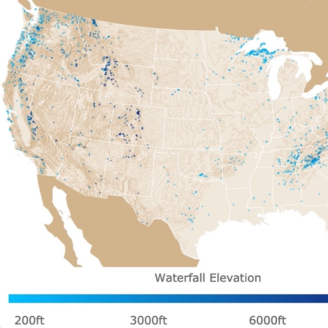
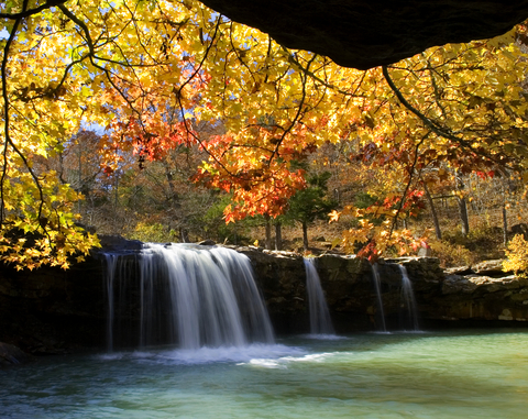
Interested in Waterfalls? Check this map of U.S. Waterfalls.
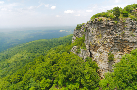
Arkansas's Mountains
Arkansas's two mountain ranges, the Ouachita Mountains and the Ozark Mountains (also called the Ozark Plateau), are the only notable highland regions between the Rockies and the Appalachians.
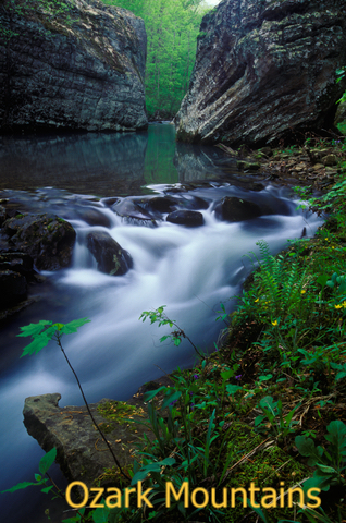
The Ozark Mountain stands tall in the northwestern corner of Arkansas and extends into southern Missouri. This heavily forested upland region of the state is blessed with abundant streams and rivers.
The Ouachita Mountains are separated from the Ozarks by the Arkansas River Valley. The mountains occupy west-central Arkansas and stretch into eastern Oklahoma.
The ridges of the Ouachita are oriented in an east-west direction, instead of a north-south like the Appalachians and Rockies; that's unusual for a North American mountain range.
Arkansas's highest point is Mount Magazine in the Ouachita Mountains measuring 2,753 feet (838m).
Mississippi River Valley
The Mississippi River forms Arkansas' boundary with Tennessee and Mississippi. The third eastern portion of Arkansas is part of the Mississippi's alluvial plain.
When the flat landscape shifted course, it left behind a flat terrain.
All of the water flowing throughout Arkansas flows into the Mississippi or one of the distributary channels in Louisiana.
The Arkansas River starts in Colorado and runs southeast through Oklahoma and Kansas. It enters Arkansas near Fort Smith and travels over 300 miles before flowing to the Mississippi River.
The Red River, White River, Black River, Ouachita River, and St. Francis River flow toward the south or southeast.
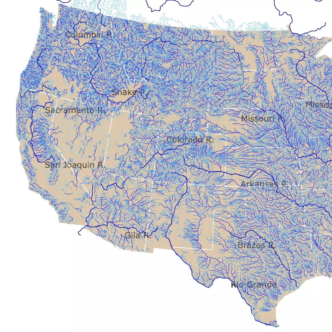
For more information on rivers, check this map of US Rivers!
Arkansas's Lakes
All of the major lakes in Arkansas are man-made reservoirs formed by building a dam to flood the area behind it. Bull Shoals Lake is one of the largest in the state, and it is located in the north-central region of Arkansas.
Northeast of Hot Springs, you'll find the Ouachita River flowing into Lake Ouachita. Boaters love to explore and navigate the 200 islands and countless tree-tops left before Blakely Mountain Dam was built.
Arkansas Climate
The entire state of Arkansas experiences all four seasons. However, the slight geographical differences between the highlands and lowlands cause minor climate variations between each region.
According to WeatherSpark, Arkansas summers are long and hot, while winters are typically short, wet, and cold.
- Average High January: 53°F (11.66°C)
- Average Low January: 36°F (2.22°C)
- Average High July: 92°F (33.33°C)
- Average Low July: 74°F (23.33°C)
The best times to visit Arkansas:
- Mid-April to early June and early September to mid-October for warm-weather activities. Any later than June is too hot, and late October is wet and cold.
- Late October through the winter holidays offer numerous winter activities.
Best Arkansas Parks and Outdoor Areas
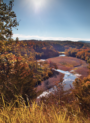
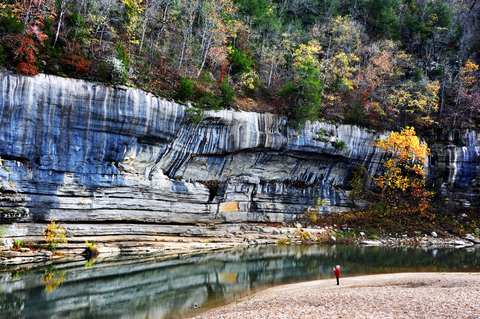
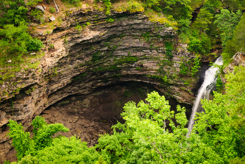
Buffalo National River
The Buffalo National River is one of the few remaining undammed rivers in the lower 48. It is the red stripe in northern Arkansas.
The Buffalo flows freely for over 100 miles. A journey can bring you to the running rapids or the quiet, relaxing pools. The massive bluffs are picturesque, and they're the scenery surrounding you as you travel through the Ozark Mountains, down to the White River.
2020 was the 50th Anniversary of the National River's establishment or founding. NPS Buffalo
Springtime marks the beginning of paddle season. The amount of water makes this a prime location for high-level whitewater kayaking.
The activities change from month to month based on the amount of rainfall. The Buffalo National River is unlike those fed by perennial springs. The river is extensively rainfall-dependent, so there might not be enough water for certain recreational activities without rain.
Several campgrounds are maintained by the Buffalo National River throughout the park. From primitive sites with vault toilets, no running water, and no electric or water hook-ups, to highly-developed sites with extra accommodations.
The Collier Homestead is located at Tyler Bend at the Buffalo National River. It's a well-constructed piece of history where the Collier Family once lived.
This 20th-century homestead is a hidden gem within the park. The preservation of historic landscapes and structures is a priority in the Natural State, Collier
There's no entry fee for the Buffalo National River. Campsites require payment unless you're going backcountry camping. Depending on the amenities and accommodations, camps range from $16 to $50 a night.
Several picnic pavilions are free if you're planning on a picnic during a day visit. However, the drive-in and group pavilions require a fee.
In case you want to learn more about the Forest Service, visit this map of National Forests
Ozark National Forest
The Ozark National Forest spans over 1 million acres. It is made by the green polygons in Northern Arkansas.
The Ozark-St. Francis National Forests are two distinct and separate forests with many differences; however, each makes up a portion of the National Forest system.
The Ozarks are home to Mount Magazine, the tallest mountain in the state. Although the mountain-top is flat, it still reaches 2,753 feet (839.11 meters) in elevation.
Ozark National has some of the best hiking trails. There are over 300 miles of trails throughout the forest; you can travel them all and never see the same view twice.
Alum Cove trail is only a little over a mile long. Still, it leads you to a beautiful, natural stone bridge (there are several throughout the state of Arkansas).
The Huckleberry Mountains Horse Trail offers over forty miles of trails and two main loops, perfect for horseback riding.
Arkansas is home to many caverns and caves, including a living, underground cave called Blanchard Springs Caverns. Blanchard Springs Caverns is located in Stone County, 2 miles off Highway 14 near Mountain View. There are two different trails to follow, and there's also the Wild Cave Tour that detours into off-trail caving. Forest Service
The recreational activities at the Ozark National Forest include camping, swimming, fishing, hiking, hunting (with proper permits), boating, picnic sites, scenic drives, and plenty of wildlife to explore.
Mount Magazine State Park
Mount Magazine State Park is nestled inside the southern portion of the Ozark National Forest.
The highlight of this state park's experience is Mount Magazine or Magazine Mountain. The views, alone, draw in a large crowd, but there's more to see and do here. Exploration, relaxation, and nature study are just a few of the more laid-back things to do while at Mount Magazine.
Outdoor sports are a massive deal at Mount Magazine. As are extreme adventures like horseback riding, mountain biking, backpacking, and ATV riding.
Speaking of extremes, Mount Magazine is the most scenic location for technical rock climbing in the state park system; it's one of two parks that offer hang gliding launch areas!
The scenic overlooks, trails, pavilions, picnic area, and pavilion area only add to the amenities. The visitor center has a gift shop too. A wide variety of programs led by park interpreters highlights the mountain's natural diversity.
Book a room at The Lodge. Mount Magazine's lodge features 60 guest rooms, a conference center, fitness center, game room, heated indoor swimming pool, business center, and the Skycrest Restaurant.
The Lodge setting is on the mountain's south bluff with breathtaking views of the Blue Mountain Lake and Petit Jean River Valley. You'll experience first-class facilities in a beautiful country setting. Magazine State Park
If the Lodge is too much for you, various cabins and campsites are available.
Curious about caves? This map has the location of many U.S. caves
Crater of Diamonds State Park
Crater of Diamonds State Park is a lime green polygon northeast of Texarkana.
Crater of Diamonds is one of the only places on the planet where the public is allowed to search for diamonds. Diamond hunters are welcome to visit the crater to find natural diamonds and precious stones straight out of their volcanic source.
People from all over the world come to Murfreesboro, Arkansas, to the Crater of Diamonds. Visitors can search a 37-acre field for minerals, rocks, and gemstones.
Anything you find is yours to keep. Bring your own hand, mining equipment, or rent tools from the park for a small fee.
If you've never searched for diamonds or precious gems, you can learn all about diamonds and mine them. The visitors center offers real, uncut diamonds on display and interactive exhibits that teach history and geology.
The Diamond Discovery Center teaches you more about minerals and rocks and how to find diamonds using different methods.
Diamonds come in every color of the rainbow, but the three colors found at the Diamond Crater are yellow, brown, and white. Amethyst, agate, quartz, and jasper are a few other stones naturally occurring in the area.
After a good day of searching for gems, you can take a walk on one of the trails, enjoy a picnic, camp out at one of the 47 campsites tent sites, stop at the gift shop, and visit the Diamond Springs Water Park. Crater of Diamonds
Devil's Den State Park
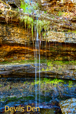
Devil's Den is the small, lime green area south of Fayetteville.
This park is recognized thanks to its waterfalls, caverns, and biking trails.
Hot Springs National Park
Situated in central Arkansas, this National Park is mainly focused on visitors and tourists looking to relax.
The park is rich in culture and history. It is still possible to soak outdoors; the best way to enjoy this park is by visiting the bathhouses.
Want to visit more hot springs? Click on this map of U.S. Natural Hot springs
Pinnacle Mountain State Park
This state park, depicted in lime green, is just west of Little Rock, Arkansas capital. Pinnacle Mountain stands out as the centerpiece of this geographically diverse park.
Pinnacle Mountain State Park is a day-use park with numerous outdoor adventures waiting to be had on the Big and Little Maumelle Rivers.
The Arkansas Arboretum is a 71-acre site where you can exhibit the flora of the six natural divisions of the state.
Over 22 miles of trails, with over 14 miles of challenging mountain bike trails, bring people out to the park almost all year long. Hike to the top of Pinnacle Mountain, explore the rivers or learn about the area's diversity.
Pinnacle Mountain State Park is certified and recognized as a Trail of Tears National Historic Site. Many hardships were witnessed by the removal parties of the natives, including the Chickasaws, Choctaws, Creeks, and Seminoles, Trail of Tears.
Petit Jean State Park
The Petit Jean State Park is located in central Arkansas, west of Conway.
Petit Jean State Park is a popular park in Arkansas. It's a natural and historical gem that's been welcoming travelers for decades.
The geology and natural beauty of the Petit Jean Mountain caused the creation of Arkansas's first state park. Petit Jean State Park mirrors the mountain's rocky and rough beauty with the plain style, stone, and native log facilities.
The beautiful and historic Mather Lodge is a 24-room lodge overlooking Cedar Creek Canyon. The club also has a restaurant, gift shop, and meeting rooms. The fireplace is welcoming and inviting. Near Mather Lodge are cabins along the bluff, with stunning canyon views.
There is plenty to do out across the 100 acres. The boathouse is open during the summer months. Campsites are available, and there are plenty of fish to be caught and kayaking to be done.
The park offers two swimming pools, playgrounds, picnic areas, a launch ramp, and a tennis and basketball court. Hike the land through the forests and meadows, along streams, and over canyons, Petit Jean.
Want to find places to explore in nearby Oklahoma? Check this map of Oklahoma Parks
Queen Wilhelmina State Park
The Queen Wilhemina is the lime green speck close to Oklahoma. The park is surrounded by the Ouachita National Forest.
Queen Wilhelmina is located on top of Rich Mountain, which is Arkansas's second tallest peak. This park offers some of the most incredible views from the lodge. The Talimena National Scenic Byway is a scenic path to follow.
Queen Wilhelmina State Park is rich in history. The original lodge was built back in the late 1800s as a Victorian resort, appropriately named Wilhelmina Inn, in honor of the young Queen of the Netherlands. Since two inns followed the original Castle In The Sky.
The park offers campsites, trails, and picnic areas. Learn about the unique flora and fauna of Rich Mountain through one of the Interpretive programs, Wilhemina.
Affiliate Disclosure
Databayou.com is a participant in the Amazon Services LLC Associates Program, an affiliate advertising program designed to provide a means for sites to earn advertising fees by advertising and linking to Amazon.com. Databayou.com also participates in affiliate programs with Clickbank, CJ, and other sites.
If you plan on visiting one of these arid parks or hiking up the Ozarks, I suggest you get some of these items found on Amazon.
- Geology Rock Pick Hammer Kit: This comfortable vest and pack holds 2 Liter of water and is designed for quick loading and refilling.
- Merrell Waterproof Hiking Boot: Ideal for walking comfortably through Arkansas trails.
- Coleman Sleeping Bag: This is an all weather, multilayer sleeping bag for camping and outdoor sleeping.
Resources for Arkansas's Protected Areas Map
The shapefiles with Arkansas's state boundary lines, major rivers, and cities were downloaded from Natural Earth Data.
The Parks and Public Lands shapefiles for Arkansas were downloaded from USGS.
This map will be updated with new data! To receive updates on this and more nature maps, join my email list!!!!!!!
Made by Luz K. Molina with D3.js.