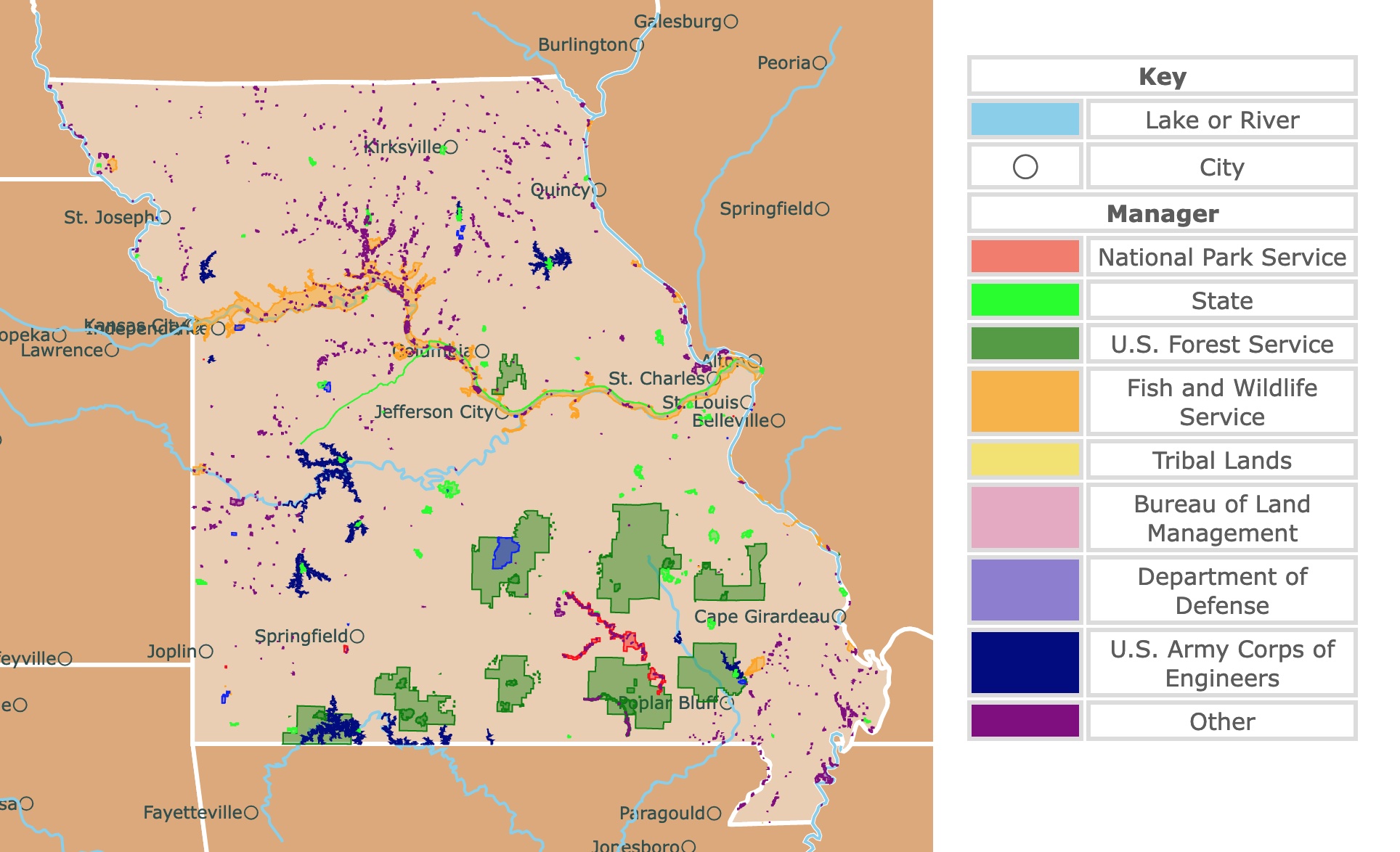
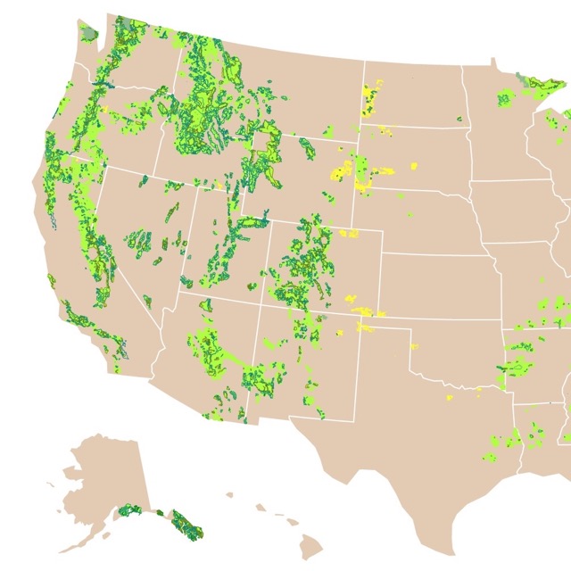
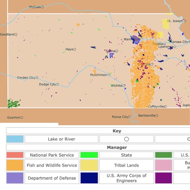
Map of Missouri's Protected Areas
This interactive map shows the Locations, Names, Areas, and Details of National Parks, State Parks, National Forests, Tribal, and other Public Lands of Missouri. It also shows major cities and rivers for context. For more detail, zoom in. For more information, hover over the map, or scroll down.
| Key | |
|---|---|
| Lake or River | |
| ◯ | City |
| Manager | |
| National Park Service | |
| State | |
| U.S. Forest Service | |
| Fish and Wildlife Service | |
| Tribal Lands | |
| Bureau of Land Management | |
| Department of Defense | |
| U.S. Army Corps of Engineers | |
| Other | |
Missouri's Geography
Missouri gets its name from the "Missouri" Native American tribe. It comes from "ouemessourita", roughly translated as "wooden canoe people" or "those who have dugout canoes", Newskudo".
How the Show-Me State got its nickname is up for debate. However, the story goes that a Missouri congressman once said, "I'm from Missouri. You've got to show me." The statement means that actions speak louder than words.
Missouri is bordered by Iowa to the north; Arkansas to the south; Illinois, Tennessee, and Kentucky to the east; and Kansas, Oklahoma, and Nebraska to the west. Looking at a map, you'll notice the wiggly eastern border, almost entirely created by the beautiful Mississippi River.
Missouri can be separated into four geographical regions:
- The Dissected Till Plains cross the far north above the Missouri River. The area mainly consists of flat prairie land with fertile soil, streams, and rivers.
- The Osage Plains are located in western Missouri, and they're primarily flat with a few hills here and there. In this region, the soil is shallower and less rich than what's found in the Till Plains. Tallgrass once covered over 15 million acres in Missouri but now little remains. Prairie State Park is located in this region, and they preserve these incredibly grasses.
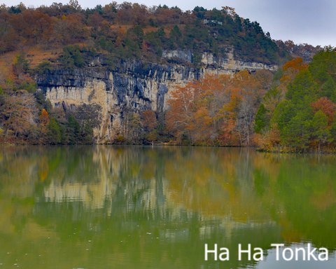
- The Ozark Plateau is Missouri's most prominent geographical region, covering most of the state's southern half. Gradual water erosion created high, forested ridges, caves, and lakes in this area. The state's highest point, Taum Sauk Mountain, is in the Plateau region, as is the Lake of the Ozarks, a reservoir where visitors come to camp, fish, and boat.
- The Mississippi Alluvial Plain is the lowlands in the southeastern corner of Missouri. It's also called the state's "Boot Heel". Flooding of the Mississippi River caused the land to be very fertile, opening up opportunities for growing soybeans, rice, and cotton.
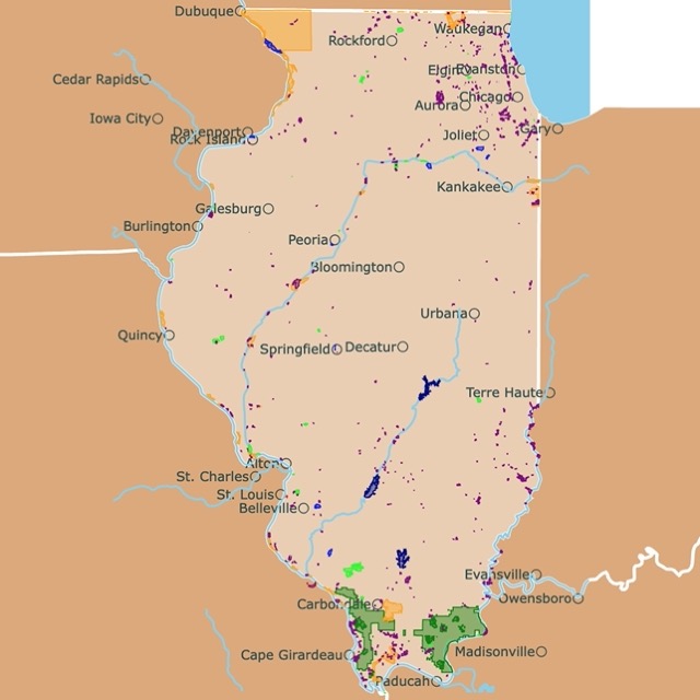
Interested in nearby Illinois? Check this map of Illinois Parks and natural areas.
Missouri's Plants and Wildlife
Missouri is home to the largest mammal in North America, the American bison. Black bears, mountain lions, bobcats, and endangered gray wolves live freely in the state.
Eastern screech-owls, purple finches, and Peregrine falcons are some of the birds you'll find soaring through Missouri's sky.
Reptiles include alligator snapping turtles, the prairie massasaugas (a breed of rattlesnake), and Great Plains rat snakes call Missouri home. Meanwhile, bullfrogs and cave salamanders are a couple of the local amphibians.
A wide variety of trees grow in Missouri, including the eastern redbud, white oaks, eastern wahoo, and black walnuts. However, the state is well-known for the prairies, where hundreds of grass species grow. You'll find switchgrass, bluestem, Indian grass, and June grass, among other grasses.
Wildflowers such as putty root, Ozark Bluestar, and yellow lady slippers bloom through the beautiful state.
Missouri's Climate
Missouri experiences a continental type of climate. The state averages 43 inches (1m) of rain a year. The annual snowfall averages about 13 inches (33cm).
July averages 88°F (31°C) while January averages 20°F (-6.66°C).
September, May, and June seem to be the best months in Missouri regarding weather and climate. December and January are the least favorable times to visit.
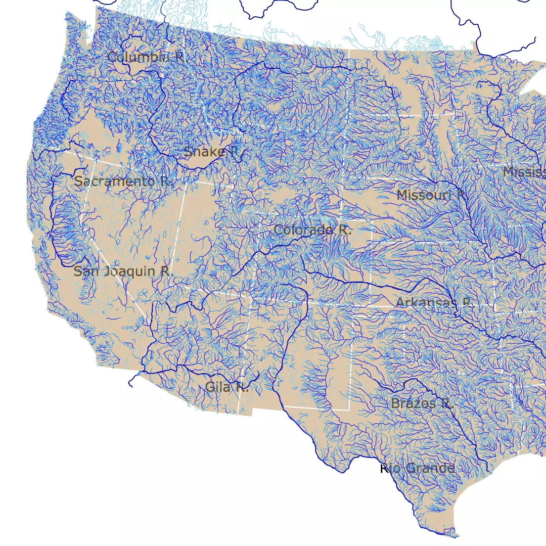
Missouri has lots of rivers to discover and enjoy. For more details, visit this map of U.S. Rivers.
Beautiful Parks and Forests of Missouri
Gateway Arch National Park
I know this is an unpopular opinion but I do think the Arch deserves to be called a National Park.
We were crossing the country from the Gulf Coast to Minnesota and decided to make a small detour to the park.
It is impressive, beautiful, and worth the visit. From a distance you feel chills at its size and beauty.
Its location by the Mississippi River makes absolute sense.
You need tickets for the top of the arch. For the bottom there is a really cool exhibit about the cultural groups who helped shape U.S. history, and St. Louis’ role in westward expansion.
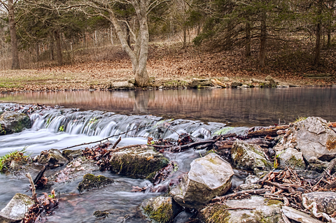
Ozark National Scenic Riverway
The Ozark National Scenic Riverway is the long red strip in southern Missouri.
The Scenic Riverway is the first national park area to protect a river system. The Jack Fork and Current rivers are two of the most incredible floating rivers around the US.
.These rivers are spring-fed, clear, and cold, making them ideal for sweltering summer afternoons.
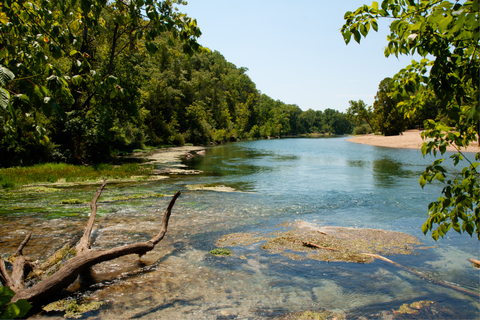
Visitors enjoy swimming, floating, and canoeing on both rivers. Aside from the Jack Fork and Current Rivers, the park is home to hundreds of freshwater springs, trails, caves, and historic sites like Alley Mill.
The park has several incredible hiking trails, including the Ozark Trail, Round Spring Trail, and Equestrian trails for the horses.
Visitors can take a guided cave tour through the Round Springs Cave during the summer months. The Big Spring Slough Trail is wheelchair accessible.
Ozark National Scenic Riverway has several different campgrounds to choose from, including primitive and modern sites. Floaters are permitted to camp on any gravel bar, as long as it's not within half a mile from a campground.
Lodging is typically available at the Big Spring Dining Lodge and Cabins; however, from time to time, it's closed for renovations, so be sure to check in first, Ozark.
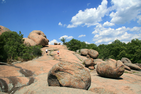
Elephant Rocks State Park
Elephant Rock State Park is a small lime green area northwest of Cape Girardeau.
The park is named after the elephant-shaped boulders found around the park. These giant granite boulders are the focal point of the park.
 .
.
The elephant rocks were formed from 1.5-billion-year-old granite. They're giant boulders that stand next to each other like a train.
These rock formations intrigue geologists. They are popular with tourists and fascinate little ones that love to play around the enormous rocks.
One of the easy ways to see the elephant rocks is from the Braille Trail. This trail was specifically designed for people with disabilities.
Braille Trail goes through the park's heart and leads to the old railroad engine house, Elephant Rocks.
You'll find picnic tables under the trees, with spots to enjoy lunch or rest in the shade.
Bouldering, a form of rock climbing performed without ropes or harnesses, is popular at Elephant Rocks State Park. Bouldering is permitted all year long and shouldn't interfere with any of the other park visitors.
Looking for more National Forests? Visit this map of the Forest Service
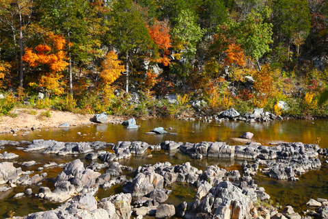
Roaring River State Park
Roaring River State Park is depicted in lime green and situated close to the state's southwest corner.
Roaring River State Park is considered one of Missouri's most popular state parks. The deep, narrow valley is encircled by an irregular landscape.
The park is located in the southwest Ozark hills and is one of three state parks stocked well with rainbow trout. It's a hot spot for anglers looking to catch a few good trout.
Roaring River has hiking trails, picnic tables, and a nature center where visitors can learn all about the park.
The campground offers electric, sewer, and water amenities for visitors who want to spend the night. There are also cabins scattered around the park.
For those who prefer comfortable accommodations, there is also an inn, Roaring River.
Johnson's Shut-Ins State Park
Johnson's Shut-Ins State Park is a small lime green area northwest of Cape Girardeau.
A shut-in is a rock formation found in streams in the Ozarks. They're composed of pools, rapids, creeks, and plunge pools.
This ancient beauty is a sight to remember. The wilderness and geology of Johnson's Shut-Ins and the surrounding St. Francois Mountains are only one of the reasons the place is so popular.
The rough landscape provides the perfect setting and scenery for hiking, camping, picnicking, and enjoying a soak in the shut-ins.
Johnson's Shut-Ins offers walk-in, electric, basic, complete, and equestrian campsites.
Log cabins provide accommodations but must be reserved in advance, even though they're open throughout the year.
The park is full of incredible trails for all levels of hiking, and a playground popular with kids, Johnson's Shut-Ins.

There are many lakes in Missouri to visit. To find them, go to this map!
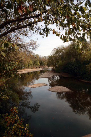
Meramec State Park
Meramec State Park is a lime green area southwest of St. Louis.
The Meramec River flows by a conspicuous cave entrance, sublime bluffs, and wooded areas. Over 13 miles of hiking trails are open for exploration.
Visitors enjoy swimming, rafting, fishing, and boating at the Meramec. A campground, cabins, and a motel are available for an unforgetful weekend getaway.
The visitor center has exhibits focused on Meramec Park.
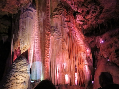
Fisher Cave astonishes visitors no matter their age. A tour guides visitors with interesting facts about the cave and its origins.
The cave not only impresses with its chambers of different sizes but its remnants of wildlife, calcite formations, and columns.
A must-see inside the cave are the stalagmites, stalactites, and helictites. These are cave formations that grow in different directions, not just down! Fisher Cave.
The Fireside Store and Grill is the place to get all of your essential items while you visit Meramec Park. Get a bite, dine-in, or stop in and pick up some snacks.
No worries if you fancy getting out on the water but don't have any gear. Kayaks, canoes, and rafts can be rented at the park for your floating pleasure. The rental prices include transportation, shuttle, paddles, and life jackets.
Mark Twain National Forest
Mark Twain National Forest is represented as several green areas in southern Missouri and is the only national forest in Missouri.
The Mark Twain National Forest consists of 1.5 million acres of public land. It's a beautiful forest maintained to preserve Missouri's flora and fauna.
This forest features permanent springs, over 5,000 caves, and volcanic mountains. Karst formations can also be admired throughout the park.
This National Forest offers a wide range of recreational opportunities. The forest has more than 750 miles of trails perfect for hiking, horseback riding, mountain biking, and motorized use. There are even segments of the Ozark Trail winding through the forest.
With miles of perennial streams, visitors enjoy canoeing, floating, and kayaking. The campgrounds include semi-primitive and wilderness camping for quiet and solitude.
With such a large forest, you'll want to have a few days to explore this natural beauty. You don't have to stick to semi-primitive and primitive camping. There are RV camping areas, cabins, and equestrian camping options. Source: Forest Service.
Interested in nearby Kansas? Check this map of Illinois Parks and natural areas.
Hawn State Park
Hawn State Park is depicted in lime green, south of St. Louis, Missouri.
The hills of precious pine and oak trees, canyons, clear streams, and sandstone cliffs create the gorgeous landscape of Hawn State Park. With almost 5,000 acres, the park offers a beautiful experience for anyone who enjoys nature and the outdoors.
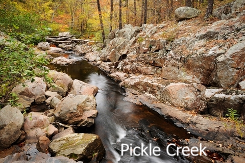
Different rock types attract visitors to Pickle Creek. This area has exposed igneous, sedimentary, and metamorphic rock.
Pickle Creek also has an impressive variety of fish because this is where prairie fish mix with Ozark fish!
The park has two more natural areas, LaMotte Sandstone Barrens with a drier landscape, exposed sandstone, and succulents. Botkin’s Pine Woods has shortleaf pines, farkleberry, blueberry, and deerberry. The Pine Woods are also characterized by beautiful birds, source: Washington University.
This amazing setting invites campers, hikers, and anyone who loves exploring. The park's campground is situated beneath the shade of beautiful conifers and includes basic campsites.
Lake of the Ozarks State Park
Lake of the Ozarks is located in central Missouri, southwest of Jefferson City.
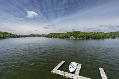
The Lake of the Ozarks State Park is the state's largest lake and the state's largest state park.
Most of the lake's shoreline is privately owned, but are two swimming beaches open for visitors.
The park has trails, caverns, and a boat launch. Visitors can go out, ride horses, and bike through the park's beautiful woodlands.
Fish, swim, boat, or simply enjoy the view from your campsite or picnic area.
This is a natural area within a short distance of developed areas with shopping and entertainment, source: Lake of the Ozarks.
Affiliate Disclosure
Databayou.com is a participant in the Amazon Services LLC Associates Program, an affiliate advertising program designed to provide a means for sites to earn advertising fees by advertising and linking to Amazon.com. Databayou.com also participates in affiliate programs with Clickbank, CJ, and other sites.
If you plan on visiting one of these parks or hiking up the Ozarks, I suggest you get some of these items found on Amazon.
- Dome Tent: This extended tent holds 9 people and three air mattresses. Perfect for a family trip to the Ozarks!
- Climbing, Caving Helmet: Ideal for exploring Missouri caves or climbing its rocks.
- Inflatable Water Float: This comfortable water float is the best buy for a chill day at one of Missouri's lakes and streams.
Resources for Missouri's Protected Areas Map
The shapefiles with Missouri's state boundary lines, major rivers, and cities were downloaded from Natural Earth Data.
The Parks and Public Lands shapefiles for Missouri were downloaded from USGS.
This map will be updated with new data! To receive updates on this and more nature maps join my email list!!!!!!!
Made by Luz K. Molina with D3.js.