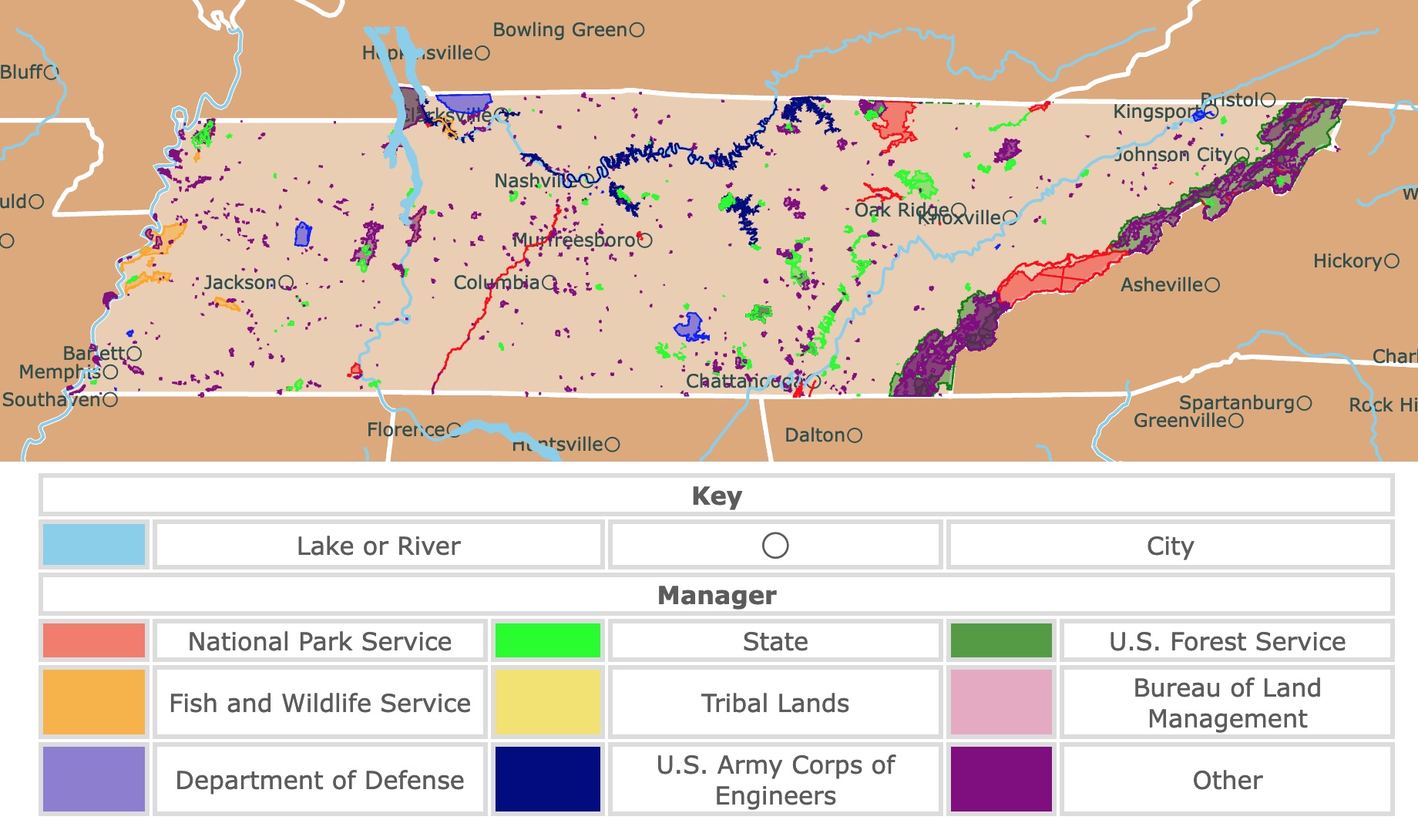
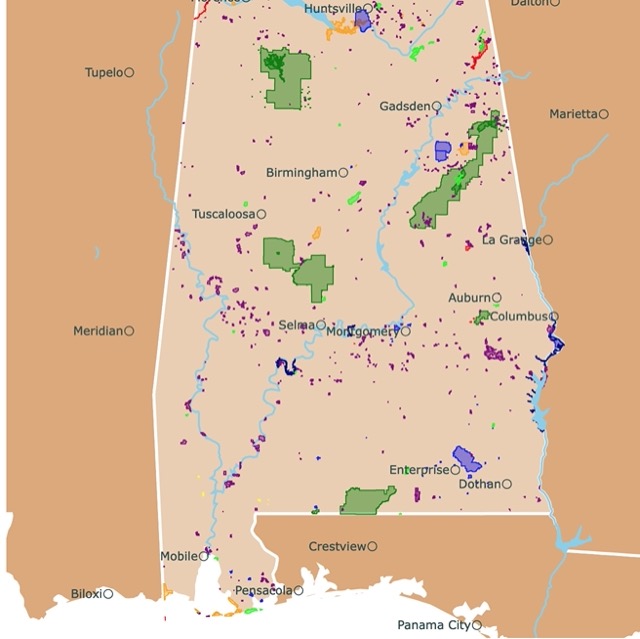
Map of Tennessee's Parks and Protected Areas
This interactive map shows the Locations, Names, Areas, and Details of National Parks, State Parks, National Forests, Tribal, and other Public Lands of Tennessee. It also shows major cities and rivers for context. For more detail, zoom in. For more information, hover over the map, or scroll down.
| Key | |||||
|---|---|---|---|---|---|
| Lake or River | ◯ | City | |||
| Manager | |||||
| National Park Service | State | U.S. Forest Service | |||
| Fish and Wildlife Service | Tribal Lands | Bureau of Land Management | |||
| Department of Defense | U.S. Army Corps of Engineers | Other | |||
Geography of Tennessee
Tennessee is surrounded by eight states: Virginia and Kentucky to the north, North Carolina to the east, Alabama, Mississippi, Georgia to the south, Missouri and Arkansas to the west. The Mississippi River forms the western border of the state.
Tennessee can geologically be divided into six major regions.
- The Valley & Ridge Region: This area lies west of the mountains, named for the long tree-covered ridges and low, fertile valleys. The ridges are sometimes known as "folds."
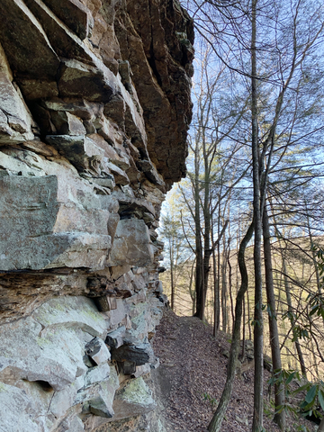
- The Cumberland Plateau: The Cumberland Plateau stretches from the north to the south and further south in Tennessee. The plateau is a rugged upland region created by streams carving through, creating deep valleys and gorges below the flat-topped mountains. Travelers used to cross it, going through the Cumberland Gap.
- The Unaka Mountains Region: This is one of the most rugged mountains in Tennesse. Unaka Mountains rise 5,200 feet (1585 meters) in elevation along the eastern border with forests and high peaks. One of them is the state's highest point, Clingman's Dome. The Great Smoky Mountains National Park is a subset of the Unaka mountains.
- The Highland Rim Region and Central Basin Region: The Basin region is located in the center of Tennessee and is surrounded by another region, the Highland Rim. The rim has rolling hills and valleys. Erosion played a part in forming the basin.
- The Gulf Coastal Plain: This region covers the westernmost part of Tennesse. This is the lowest and flattest part of the state. The Gulf Coastal Plain lay on a fault line and was the site of one of the worst earthquakes in the continental U.S. in 1812, known as the New Madrid Earthquakes; TN History.
Want to find places to explore in nearby Kentucky? Check this map of Kentucky Parks
Tennessee's Wildlife
White-tailed deer, gray foxes, bobcats, mountain lions, and black bears are a few mammals living their best life in Tennessee.
Red-tailed hawks, eastern screech-owls, red-winged blackbirds, summer tanagers, ospreys, and pileated woodpeckers (they have the Woody Woodpecker-like crest) are some of the bird species in the area.
The southern leopard frog, salamanders, and lesser sirens are some of Tennessee's amphibians.
Reptile fans should keep their eyes open for eastern fence lizards, pygmy rattlesnakes, and southern painted turtles.
Some of Tennesse's native trees include pecan, eastern red cedar, swamp chestnut oak, sugar maple, loblolly pine, and bald cypress. Beautiful wildflowers like the yellow and white Tennessee glade cress, wild bleeding hearts, and American beautyberry grow throughout the state; NatGeo.
Tennessee's Climate
Tennessee generally experiences a temperate climate. Summers are warm, and winters are mild. The temperatures have a 5 to 7-degree difference from the southern to northern regions.
The Central Basin, Gulf Coast Plain, and Sequatchie Valley are the warmest parts of the state. The average winter temperature in Memphis is about 41 ℉ (4 ℃) during January, with summer temps averaging 83 ℉ (28 ℃) in July.
The best time to visit Tennessee for outdoor activities and festivals is during the summer, from June through the end of August and September through November.
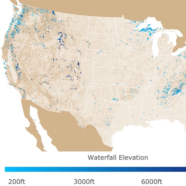
Tennessee has numerous waterfalls. To find more, visit this map.
Top Tennessee's Parks and Protected Lands
Cherokee National Forest
Cherokee National Forest is the purple and green strip of land in eastern Tennessee.
The Great Smoky Mountains National Park divides the Cherokee National Forest into northern and southern sections. Cherokee is the largest tract of land in the state, containing 650-thousand acres of forest.
Visitors will find developed campgrounds, various picnic areas, more than 700 miles of trails, two Forest Service scenic byways, seven whitewater rivers for rafting, and the Ocoee Whitewater Center. The scenic drive through the mountains is picturesque.
There are 15 different areas offering unique outdoor opportunities, from Big Frig Mountain to Watauga Lake. Several trails are perfect for hiking and biking.
Cherokee National Forest has over 150 miles of trails that are part of the Appalachian National Scenic Trail!
Canoeing, kayaking, and boating opportunities are available on various bodies of water.
Baby Falls is an excellent day-use site for picnics and fun in the water near the Bald River Falls.
Bubbling Springs Shooting Range is only a short distance off of TN 107 and offers four shooting targets ranging from 25 to 150 yards.
Bring a snorkel and head to the Conasauga River Blue Hole for a dive and swim in the deep still pools, or scan the shallow area to see what you can find.
The national forest provides habitat to over 40 species of mammals, 154 species of fish, 55 species of amphibians, and 262 species of birds; Cherokee.
Big South Fork National River and Recreation Area
Big South Fork is the big red area in northern Tennessee.
The Big South Fork National River and Recreation Area encompass over 120,000 acres in the Cumberland Plateau. It protects the incredible, free-flowing Big South Fork of the Cumberland River, its tributaries, and the wildlife throughout the area.
Miles of scenic gorges and sandstone bluffs stretch through the park, rich with historical and natural features. The area has been developed to give visitors a wide range of outdoor recreational activities.
One of the big draws to the park is its whitewater paddling opportunities. This can be a dangerous sport, but some stretches of the river are ideal for beginners.
Big South Fork offers different climbing routes thanks to the sandstone bluffs. However, it is still an adventure activity, as many of the rocks are inadequate or too soft for this.
The trails range from lazy strolling opportunities along the river to a multi-day backpacking trip through the backcountry.
Miles of horse trails, stable facilities at Bandy Creek Stables, and two equestrian campgrounds make it easy to bring your horse out to stretch its legs.
Twin Arches Trail Loop has the most impressive rock arches in eastern U.S. The South Arch has a clearance of 70 feet, a span of 135 feet, and its deck is 103 feet high.
Stop in the park's two visitor centers and learn more about the park, park features, activities, and amenities at Big South.
From the center, you can figure out which trails, overlooks, historical sites, natural elements, and programs you want to check out. It might not be easy since there are so many choices; Big South Fork.

Tennessee is covered in lush hardwood forests. Interested? Visit this link.
Fall Creek Falls State Park
Fall Creek Falls State Park is the lime area in the middle of Tennessee, north of Chattanooga.
Fall Creek Falls is one of the state's largest and most popular parks. The park offers over 29,800 acres of land stretching across the easter top of the Cumberland Plateau.
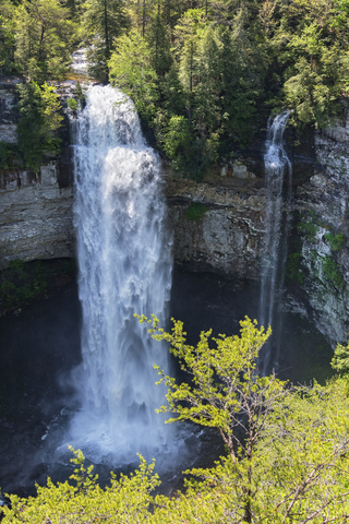
Filled with cascades, waterfalls, gorges, lush hardwood forests, and streams are waiting for visitors to come to explore.
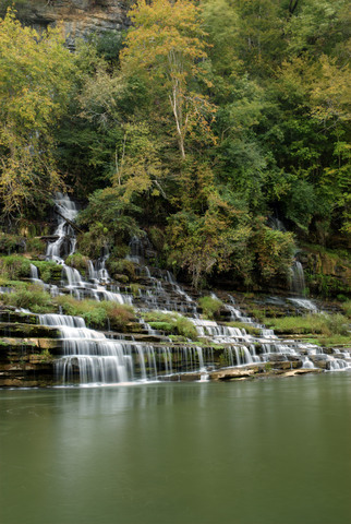
At 256 feet (78 meters), Fall Creek Falls is one of the highest waterfalls throughout the eastern U.S. Piney Falls, Cane Creek Cascades, and Cane Creek Falls are a few other beautiful waterfalls to admire.
The Canopy Challenge Course is excellent for thrill-seekers who don't mind swinging bridges on trees.
Over 56 miles of trails are available, ranging in distance, terrain, and experience levels.
The Fall Creek Falls Golf Course is popular. The 18-hole golf course is beautiful, with pro shops providing golfing lessons, supplies, rental clubs, and carts.
The park also has playgrounds, pavilions, and a swimming pool!
Visitors can book a weekend or week-long trip at one of the park's 30 cabins, over 200 campsites, an 85-room lodge, or backcountry camping areas. The Lodge at Fall Creek Falls is an excellent hotel, but it's so much more.
The Nature Center at Fall Creek Falls has hands-on environmental education through various naturalist-led programs. Other programs include movies, campfires, arts and crafts, organized games, and live musical entertainment; Fall Creek Falls.
Cumberland Trail State Park
Cumberland Trail State Park is the dotted lime green unit in western Tennessee.
The Cumberland Trail follows a line of deep gorges and high ridges along Tennessee's Cumberland Plateau. The trail links State Parklands, Natural Areas, National Parks, and Wildlife Management Areas.
The area forms natural connections, access to beautiful views and interesting geologic formations.
Black Mountain, Laurel Snow, and Deep Creek are excellent locations with rock climbing opportunities. A 210-mile network of access trails and side trails connects hikers and backpackers with scenic and historical features along the main path.
The trails are still growing and under construction. There will be over 330 miles of trails for hikers once the corridor is completed.
The Laurel-Snow State Natural Area, Black Mountain, the Tree Gorges segment and North Chickamauga Creek Gorge Natural Area are excellent locations for hiking and camping.
The Head of Sequatchie provides a peaceful setting for picnics, learning about the history and culture of the land and peoples. It's like walking onto the set of a storybook.
Educators can utilize the park's programs for educational purposes. There are various park programs; you can schedule ranger classroom or schoolyard visits and work with a ranger to create a program that suits the student's needs; Cumberland.
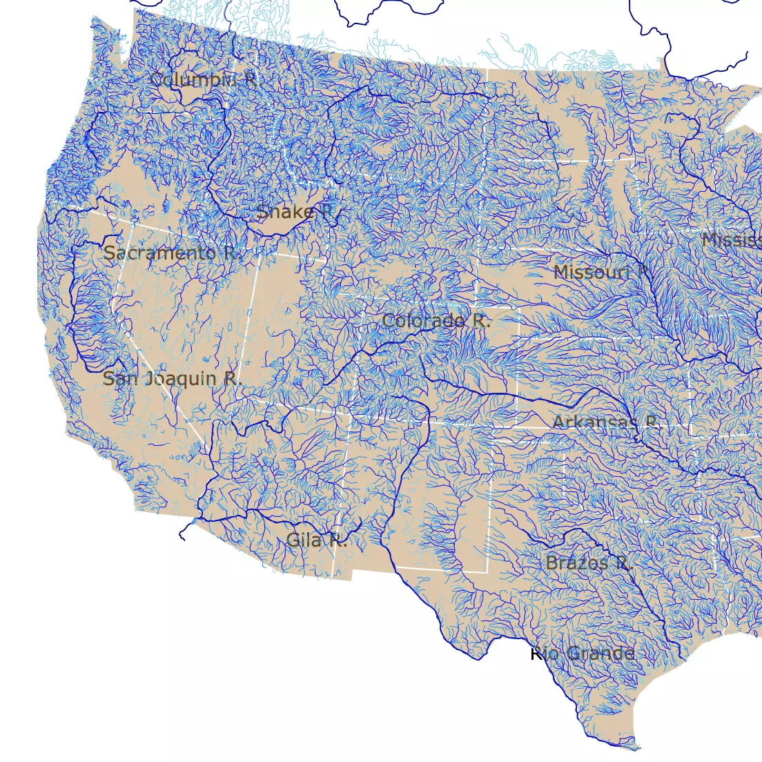
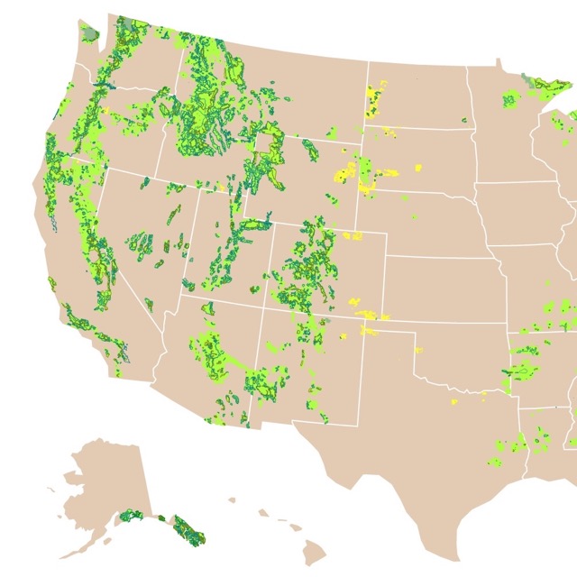
This map shows you the rivers of the U.S.A.
Reelfoot State Park
Reelfoot State Park is a lime green area in the northwestern corner of Tennessee.
The 15-thousand-acre lake was created by a series of violent earthquakes (the New Madrid Earthquakes) in 1811-1812. The earthquakes caused the Mississippi River to flow backward for a short time, resulting in the creation of Reelfoot Lake.
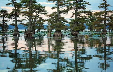
The lake is a flooded forest. Majestic Cypress trees stand tall above the water, while Cypress stumps stand below the surface. Various aquatic flowers and plants grow along the shoreline and saturate the shallow waters.
Reelfoot Lake provides an opportunity to view almost every kind of wading and shorebird, plus the American bald eagle. Reelfoot Lake is home to thousands of American bald eagles.
White pelicans stop at the lake in the hundreds during their seasonal migration every autumn.
Experienced park naturalists lead daily waterfowl and bald eagle tours. The annual Reelfoot Eagle Festival is in February, and it's an excellent bird-watching destination.
Around March and April, visitors can enjoy deep swamp canoe trips. Visit the area throughout May and September for scenic pontoon boat tours.
Boating, fishing, hiking, camping, and wildlife viewing are among this park's everyday outdoor recreational activities. Swimming is not permitted.
Two campgrounds at Reelfoot Lake; campsites provide electricity, water, and grills with tables. Many of the sites are on the lakeshore, providing a beautiful setting! Reelfoot.
Rock Island State Park
Rock Island is the lime speck east of Murfreesboro.
This 883-acre park is situated on the headwaters of Center Hill Lake, at the confluence of the Caney Fork, Rocky, and Collins Rivers.
The overlooks along the Eastern Highland Rim are incredible. The gorge and the falls have a rugged beauty not to be missed.
Great Falls is a 30-foot horseshoe cascading waterfall nestled below the 19th-century cotton textile mill. More than one hundred years ago, the mill was once powered by the falls.
Biking, hiking, camping, boating, fishing, picnics, and education opportunities are a few things to do at the park.
Rock Island Park has nine hiking trails and a natural sand beach on the headwaters of the Center Hill Lake.
There are different trails, but visitors must be watchful of the sudden changing water levels rising from the floodgates at the dam; Rock Island.
This map has the forests and grasslands of the U.S. Forest Service
Big Ridge State Park
Big Ridge State Park is the lime green area north of Knoxville.
Big Ridge is densely forested, with over 3,000 acres in the Appalachian Ridge and Valley range. These beautiful narrow ridges are bound by fertile stream valleys.
The park's topography is primarily dominated by three ridges providing the area with a gorgeous lake and surrounding scenery.
There are over 15 miles of hiking trails for different levels of expertise. The trails cross rugged areas, lakeshores, lush depressions, ridges, and even early settlers' cemeteries.
50 campsites on or near Norris Lake accommodate trailers, RVs, and tent campers. Evert site has amenities like 50-amp electrical hookups, water, a picnic table, and a grill.
A group camp is available, accommodating 120 people with 18-screened-in bunkhouses to boot. Three backcountry sites are available for those who prefer rugged outdoor life; Big Ridge.
Radnor Lake State Park
Randor Lake is the lime area just south of Nashville.
The abundance of wildlife viewing opportunities, environmental educational programs, hiking opportunities, and the fact that it's located in an urban area makes this park unique.

This state park comprises 1,368 acres of land protected as a Class II Natural Area. "Class II, natural-scientific areas, which are areas associated with and containing floral assemblages, forest types, fossil assemblages, geological phenomena, hydrological phenomena, swamplands and other similar features or phenomena which are unique in natural or scientific value and are worthy of perpetual preservation Natural Areas.
Radnor Lake State Park is a day-use only, so there are no campsites. Still, there are 7.75 miles of trails strictly for hiking, wildlife observation, and photography.
The Otter Creek Road Trail welcomes pets, jogging, and bicycles. The Lake Trail is accessible to those with all-terrain wheelchairs.
Nature enthusiasts can come to observe owls, various species of waterfowl, and herons. There are also amphibians, reptiles, and mammals, including minks and otters.
Hundreds of species of wildflowers, fungi, mosses, ferns, and a variety of other plants add to the park's natural ecological diversity; Radnor.

Tennesse has a history of Earthquakes. To learn more about them, check this map.
Burgess Falls State Park
Burgess Falls is the lime area between Nashville and Oak Ridge on the Falling Water River.
This day-use park is distinguished for its natural beauty and the four waterfalls plunging down over 250 feet (76m). One of these falls cascades more than 130 feet (39m) into the gorge!
Window Cliffs State Natural Area is a mesmerizing gem. It's a 275-acre state natural area open to the public. It has a projecting clifftop of narrow ridges along Cane Creek.
Window Cliffs is managed by Burgess Falls State Park; however, it's a separate location eight miles from the entrance to Burgess Falls.
Initially, the area was inhabited by Native American tribes, including the Cherokee, Creek, and Chickasaw. The site was used as a hunting area until the late nineteenth century; Burgess.
Want to find places to explore in nearby Alabama? Check this map of Alabama Parks
Dunbar Cave State Park
Dunbar Cave State Park is the lime polygon in northern Tennessee, next to Clarksville.
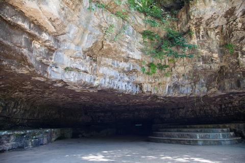
Dunbar Cave is an impressive prehistoric site. The cave has been used for thousands of years, and it's the site of a significant prehistoric Mississippian Native American cave art that dates back to the 14th century.
The park offers 144 acres of beauty and recreational opportunity. Take a guided tour of Dunbar Cave, head to the trails for much-needed hiking. Bring your camera, and capture some of the incredible wildlife roaming around; Dunbar.
Affiliate Disclosure
Databayou.com is a participant in the Amazon Services LLC Associates Program, an affiliate advertising program designed to provide a means for sites to earn advertising fees by advertising and linking to Amazon.com. Databayou.com also participates in affiliate programs with Clickbank, CJ, and other sites.
If you plan to visit one of these parks or hike up the Cumberland Plateau, I suggest you get some of these items found on Amazon.
- Inflatable Kayak: This 2 person inflatable kayak is perfect for hauling in and out of any site. It is comfortable and has a backrest.
- FOVAL 200 Watt Car Converter: Plugs into your vehicle and can charge cell phones and other items.
- Bamboo Folding Table: Perfect for camping, tailgating, barbecues, or the beach. It is lightweight and portable.
FOLLOW ME
Resources for Tennessee's Protected Areas Map
The shapefiles with Tennessee's state boundary lines, lakes, major rivers, and cities were downloaded from Natural Earth Data.
The Parks and Public Lands shapefiles for Tennessee were downloaded from USGS.
This map will be updated with new data! To receive updates on this and more nature maps, join my email list!!!!!!!
Made by Luz K. Molina with D3.js.