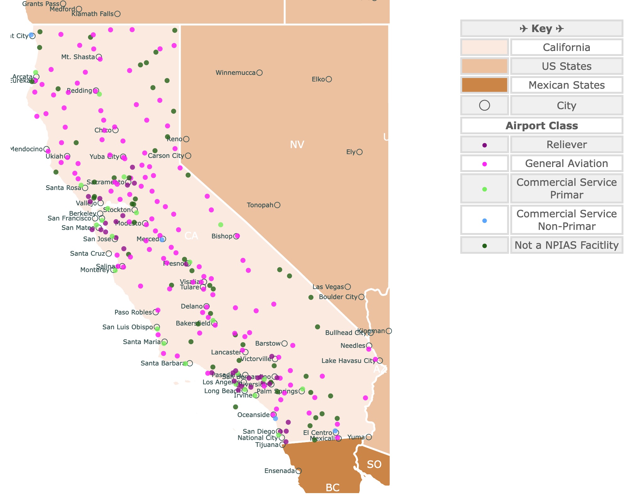
Map of California's Airports
This is an interactive map of airports in California. Each type of airport has a different color. It also displays neighboring states and cities for context. For airport name, class, location, and category hover over the map. For more detail, zoom in, or scroll down.
| ✈ Key ✈ | |
|---|---|
| California | |
| US States | |
| Mexican States | |
| ◯ | City |
| Airport Class | |
| ● | Commercial Service Primar |
| ● | Commercial Service Non-Primar |
| ● | Reliever |
| ● | General Aviation |
| ● | Not a NPIAS Facitlity |
California Airports Facts
This map of California Airports has 242 facilities. It includes major and minor airports.
California is the best-covered US state in terms of air traffic.
California’s share of national air passenger enplanements is greater than 8.9 percent.
California ranks in the top five States in the US in Aircraft, Engines, Parts & Avionics Manufacturing ($31.8); R&D ($3.8); & Air Couriers ($4.9) ($ in billions), Aviation Caucus.
Map of California Parks
California Airport Categories
According to the FAA there are 4 types of airports:
| Commercial Service Primary Airports | Airports that have more than 10,000 passenger boardings each year. |
| Commercial Service Non-Primary Airports | Airports that have at least 2,500 and no more than 10,000 passenger boardings each year. |
| Reliever | Airports designated by the FAA to relieve congestion at Commercial Service Airports and to provide improved general aviation access to the overall community. |
| General Aviation | Public-use airports that do not have scheduled service or have less than 2,500 annual passenger boardings |
NPIAS is the National Plan of Integrated Airport Systems (NPIAS) and it identifies nearly 3,300 public-use airports that are included in the national airport system.
Non-NPIAS airports do not receive federal funding; hence, they are not required to adhere to most federal grant assurances.
Although Non-NIPIAS airports are not subject to most federal requirements, they must maintain a safe operating environment for pilots and aircrafts.
If you are looking to go to California and are unsure where to land, Expedia can help:
Busiest California Airports
Los Angeles International Airport LAX
LAX serves Los Angeles and ists surrounding metropolitan area.
Los Angeles Airport was founded in 1928, and was originally known as Mines Field.
The airport is operated by Los Angeles World Airports (LAWA), a branch of the Los Angeles city government.
Based on Enplanement numbers, Los Angeles Airport is the fifth busiest airport in the USA. It is also the busiest airport in the west coast of the United States.
LAX is the international gateway for passengers travelling internationally to Asia, Oceania, Mexico, and Central America.
Map of California Counties
San Francisco International Airport SFO
San Francisco International Airport is the largest airport in the San Francisco Bay Area and the second-busiest in California.
SFO is the fourteenth-busiest airport in the United States and the 30th-busiest in the world by passenger number.
In 2022 SFO enplaned 42,136,475 passengers. 76% of these passengers had domestic flights while 24% had international flights.
Most of the international passengers came from Asia followed by Europe and then Canada. Source: FLYSFO.
San Diego International Airport
San Diego International Airport (SAN) is the busiest single-runway commercial service airport in the U.S. and the third busiest airport in California.
The airport is an economic driver for the region, contributing nearly $12 billion in economic activity in 2019 and supports nearly 116,600 jobs. Source: San
Built in 1928, the San Diego Municipal Corporation built the airfield in celebration of Charles Lindbergh, the first man to fly transatlantic nonstop.
Lindbergh had constructed and tested his record-setting plane (the Spirit of St. Louis) in San Diego.
Now days, San Diego is a major hub for Southwest Airlines, which holds 33% of the California market.
The airport has a direct connection to London's Heathrow Airport through British Airways, and a Lufthansa flight to Frankfurt. Hence the airport is a transatlantic destination.
Map of Yosemite National Park
Enplanements in California Airports
| Code | City | Airport | Enplanements 2022 |
|---|---|---|---|
| LAX | Los Angeles | Los Angeles International | 32,326,616 |
| SFO | San Francisco | San Francisco International | 20,411,420 |
| SAN | San Diego | San Diego International | 11,162,224 |
| SMF | Sacramento | Sacramento International | 6,040,824 |
| SJC | San Jose | Norman Y Mineta San Jose | 5,590,137 |
| SNA | Santa Ana | John Wayne/Orange County | 5,536,313 |
| OAK | Oakland | Metro Oakland International | 5,506,232 |
| BUR | Burbank | Bob Hope | 3,054,729 |
| ONT | Ontario | Ontario International | 2,840,758 |
| LGB | Long Beach | Long Beach (Daugherty Field) | 1,600,987 |
| PSP | Palm Springs | Palm Springs International | 1,499,987 |
| FAT | Fresno | Fresno Yosemite International | 1,077,710 |
| SBA | Santa Barbara | Santa Barbara Municipal | 610,916 |
| STS | Santa Rosa | Charles M Schulz - Sonoma | 304,053 |
| SBP | San Luis Obispo | San Luis County Regional | 273,690 |
| MRY | Monterey | Monterey Regional | 230,669 |
| BFL | Bakersfield | Meadows Field | 141,352 |
| ACV | Arcata | California Redwood Coast- | 118,924 |
| RDD | Redding | Redding Regional | 98,725 |
| SCK | Stockton | Stockton Metro | 74,529 |
| SMX | Santa Maria | Santa Maria Public/Capt G Allan | 15,911 |
| BIH | Bishop | Bishop | 10,754 |
| SBD | San Bernardino | San Bernardino International | 10,142 |
| RIV | Riverside | March ARB | 42,171 |
| CCR | Concord | Buchanan Field | 10,588 |
| IPL | Imperial | Imperial County | 9,180 |
| CEC | Crescent City | Jack McNamara Field | 8,218 |
| VNY | Van Nuys | Van Nuys | 7,551 |
| HHR | Hawthorne | Jack Northrop Field/Hawthorne | 5,001 |
| MMH | Mammoth Lakes | Mammoth Yosemite | 4,056 |
| CRQ | Carlsbad | McClellan-Palomar | 3,715 |
| MCE | Merced | Merced Yosemite Regional | 3,431 |
| SQL | San Carlos | San Carlos | 2,957 |
| SUU | Fairfield | Travis AFB | 1,407 |
| TRK | Truckee | Truckee-Tahoe | 1,028 |
| NTD | Point Mugu | Point Mugu NAS | 930 |
| NKX | San Diego | Miramar MCAS (Joe Foss Field) | 805 |
| APC | Napa | Napa County | 682 |
| VCV | Victorville | Southern California Logistics | 627 |
| MCC | Sacramento | McClellan Airfield | 533 |
| NJK | El Centro | El Centro NAF (Vraciu Field) | 471 |
| NZY | San Diego | North Island NAS (Halsey Field) | 365 |
| SLI | Los Alamitos | Los Alamitos AAF | 331 |
| SDM | San Diego | Brown Field Municipal | 274 |
| NUQ | Mountain View | Moffett Federal Airfield | 268 |
| CMA | Camarillo | Camarillo | 193 |
| SMO | Santa Monica | Santa Monica Municipal | 139 |
| TRM | Palm Springs | Jacqueline Cochran Regional | 127 |
| TVL | South Lake Tahoe | Lake Tahoe | 95 |
| NLC | Lemoore | Lemoore NAS (Reeves Field) | 93 |
| PRB | Paso Robles | Paso Robles Municipal | 88 |
| F70 | Riverside (County) | French Valley | 81 |
| BAB | Marysville | Beale AFB | 71 |
| HWD | Hayward | Hayward Exec | 68 |
| SAC | Sacramento | Sacramento Exec | 53 |
| MYF | San Diego | Montgomery-Gibbs Exec | 52 |
| OXR | Oxnard | Oxnard | 42 |
| UDD | Palm Springs | Bermuda Dunes | 41 |
| MHR | Sacramento | Sacramento Mather | 38 |
| LVK | Livermore | Livermore Municipal | 33 |
| DVO | Novato | Gnoss Field | 32 |
| IZA | Santa Ynez | Santa Ynez/Kunkle Field | 26 |
| CXL | Calexico | Calexico International | 23 |
| VIS | Visalia | Visalia Municipal | 23 |
| HJO | Hanford | Hanford Municipal | 12 |
| L22 | Yucca Valley | Yucca Valley | 11 |
| SEE | San Diego | Gillespie Field | 11 |
| WJF | Lancaster | General Wm J Fox Airfield | 11 |
| TOA | Torrance | Zamperini Field | 10 |
| LHM | Lincoln | Lincoln Regional/Karl Harder Field GA | 10 |
| PAO | Palo Alto | Palo Alto | 9 |
| 99CL | El Mirage | El Mirage Field Adelanto | 8 |
| CIC | Chico | Chico Regional | 8 |
| CVH | Hollister | Hollister Municipal | 8 |
| DWA | Davis | Yolo County | 8 |
| MER | Atwater | Castle | 8 |
| MPI | Mariposa | Mariposa-Yosemite | 8 |
| APV | Apple Valley | Apple Valley | 7 |
| IYK | Inyokern | Inyokern | 7 |
| OVE | Oroville | Oroville Municipal | 7 |
| A30 | Fort Jones | Scott Valley | 6 |
| E45 | Groveland | Pine Mountain Lake | 6 |
| MHV | Mojave | Mojave Air & Space Port/Rutan | 6 |
| AVX | Avalon | Catalina | 5 |
| AUN | Auburn | Auburn Municipal | 4 |
| A26 | Adin | Adin | 3 |
| L70 | Agua Dulce | Agua Dulce | 3 |
| O16 | Garberville | Garberville | 3 |
| WVI | Watsonville | Watsonville Municipal | 3 |
| EMT | El Monte | San Gabriel Valley | 2 |
| LLR | Little River | Little River | 2 |
| MYV | Marysville | Yuba County | 2 |
| O61 | Cameron Park | Cameron Park | 2 |
| E16 | San Martin | San Martin | 1 |
| PTV | Porterville | Porterville Municipal | 1 |
| RIU | Rancho Murieta | Rancho Murieta | 1 |
| WHP | Los Angeles | Whiteman | 1 |
FOLLOW ME
Resources for California Airports Map
The shapefiles for cities came from Natural Earth.
Enplanement Data was obtained from the FAA.
Airport location downloaded from California State Geoportal.
This information will also improve with your suggestions. To receive updates on this and more nature maps, join my email list!!!!!!!
Made by Luz K. Molina with D3.js.