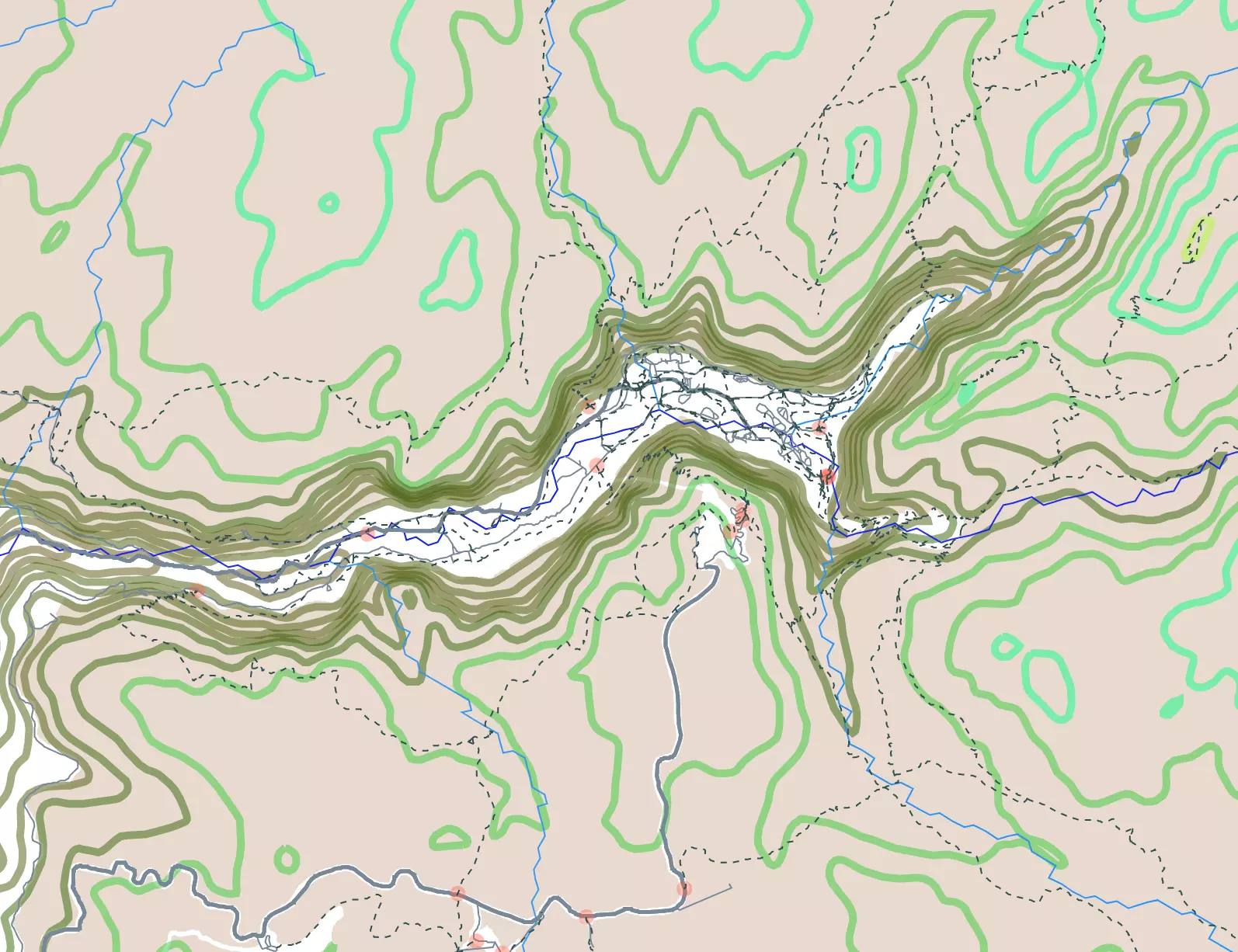
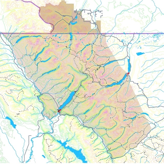
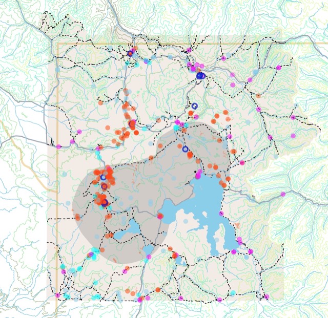
Yosemite National Park Elevation and Trail Map
This interactive map shows the contour lines of Yosemite National Park. Darker colors represent lower elevations. The map also indicates rivers, roads, and trails around the park. For more detail, zoom in. For names and facts, hover over the feature. For more information, scroll down.
| KEY | |
|---|---|
| Yosemite National Park | |
| Rivers | |
| ━━━ | ━━━ |
| Road | |
| ━━━ | |
| Trail | |
| - - - - | |
| Trail Head | |
| ● | |
Elevation Contours (feet)
Yosemite National Park
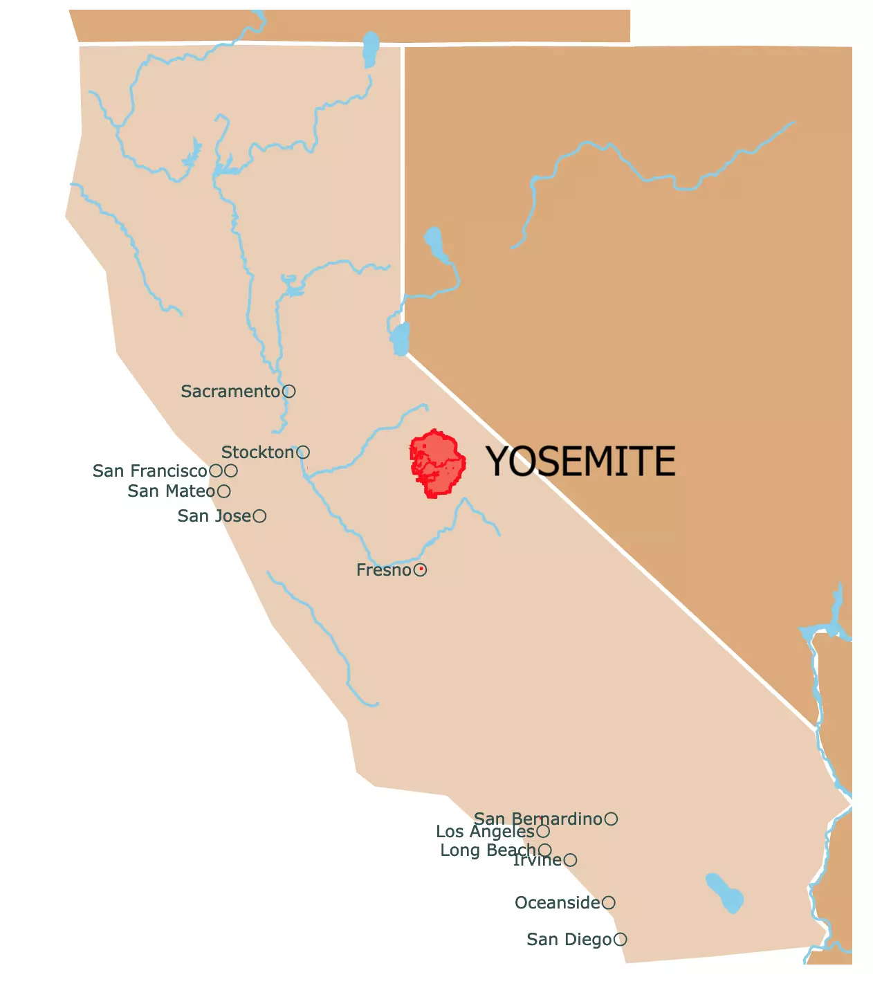
Located 165 miles (265 Km) east of San Francisco, on the western slopes of the Sierra Nevada Mountains, near the eastern border of the State of California.
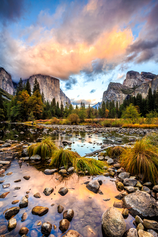
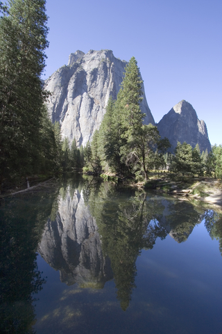
Yosemite is known for its scenery, valleys, cliffs, mountains, glaciers, and waterfalls.
Yosemite Climate
Yosemite has long, hot summers and mild winters. Conditions in higher elevations are colder year-round.
Precipitation varies from 36 inches (915mm) at 4,000 feet (1200m) elevation to 50 inches (1200mm) at 8,600 feet (2600m); Yosemite Water.
Most precipitation in the park falls as snow that accumulates above 6,000 feet (1,828m) during winter. This snow, once melted, is essential for plants and animals in the area.
Independent of the season, you want to get your tickets to California early. You can reserve your seat now with Expedia. For prices and fares, go here!
Visiting Yosemite
Extremely popular park. The busiest time is summer, but it is also when most of its features are accessible.
If you have the flexibility to go in spring, May is an excellent time to go. Waterfalls are at their peak, thanks to the melting snow.
Wintertime is magical, but because of the snow, many roads end up closing.
Fall has the beautiful colors of leaves turning red and yellow; it is also a bit chilly but great for long hikes.
There is a fee to enter unless visitors have their National Parks Pass.
Visitors may use their National Parks Pass but still need an additional day-use pass. Visitors must reserve a time slot if they do not want to be turned away. Check Recreation.gov before visiting.
If possible, try to stay in the park. Nevertheless, it is always very busy for hotels, cabin rentals, and campsites.
Hotels are not close. Once you reach the South Entrance, it takes a 1-hour drive to reach Yosemite Valley.
If you decide to stay nearby, visitors have different options, from lodges to cabins, from resorts to RV parks. For details and prices, go to Hotels.com.
Visitors who arrive through the South Entrance will get through Wawona Tunnel, which is 0.8 miles (1,290 m) long. Wawona Road is on the park's west side and is visible on the map.
The first thing visitors see once they exit the tunnel is a view of the main attractions.
The best way to get around the valley is by using bikes. There is no need to fight for parking, and it is possible to rent them inside the park.
There are also free shuttles to move around, or you may take your car, but remember, paring is not easy.
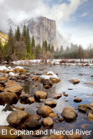
The valley has everything, waterfalls, El Capitan, and Half Dome. All visible from a bike in one day.
Map of the Grand Canyon National Park
Hikes and Trails at Yosemite National Park
On the map above, you will see trails in dotted lines and trailheads in orange circles.
Below are a few short descriptions of some trails.
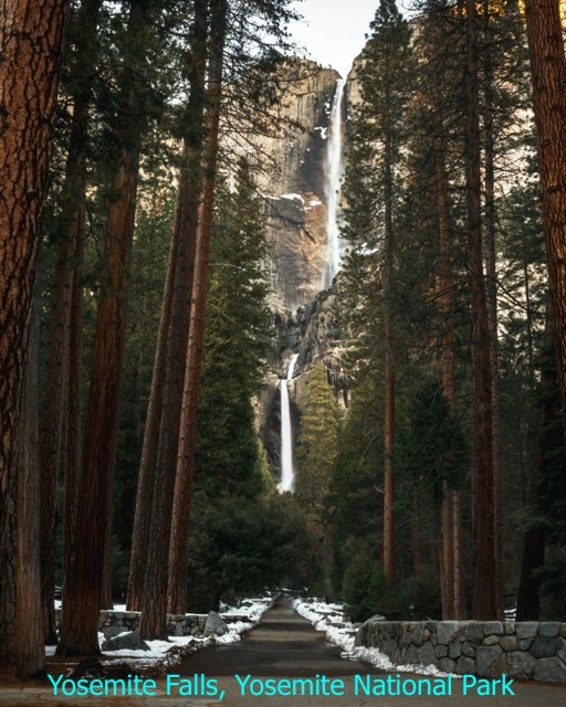
- Lower Yosemite Falls Trail: This is an easy trail with lots of scenery and incredible views of Yosemite Falls.
- Upper Yosemite Falls Trail: This is a difficult trail, but it has incredible scenery.
- Mirror Lake Trail: If you hike this trail, you can swim in the lake and admire its reflection, as long as it is not a dry season. Otherwise, it is the closest you will get to the base of Half Dome.
- Pohono Trail: This is a long and difficult trail along the south rim of Yosemite Valley. From here, you will pass Glacier, Taft, Dewey, Crocker, Stanford, and Inspiration Points, along with Sentinel Dome and the Tunnel View. This trail will offer a birds-eye of Yosemite Valley and its best attractions.
- Four Mile Trail: Also on the south rim. It is a rugged and steep trail. There are different points of incredible views. From here, you can see Yosemite Falls in its entirety from the opposite side of the valley.
- Chilnualna Falls: Situated on the southwest border of the park. This trail has three beautiful waterfalls, but the hike is strenuous.
- Mariposa Grove: It is on the southern border of Yosemite National Park. It is worth hiking to see the sequoia trees; Yosemite Hikes.
Before beginning your journey, remember that Yosemite has the second-highest death rate of all national parks. Due to remote wilderness, cliffs, and wildlife, especially bears. Outforia
Also, remember these are delicate ecosystems and geologic features prone to erosion, so leave no trace.
Map of Glacier National Park and Waterton Lakes National Park
Geology of Yosemite
When visitors go to Yosemite, they are probably not thinking of Geology, but it is likely the main reason the park is so charming and unforgettable.
True granite rocks from Yosemite park are part of the Sierra Nevada Batholith. Most of the Batholith was created 100 million years ago, during the Cretaceous Period.
This process started when the tectonic plates collided, and the denser plate was forced downward, forming a chain of volcanoes.
The Batholith is a huge mass of intrusive igneous rock. These intrusive igneous rocks were formed from magma. Magma is molten rock that cooled down slowly, many miles below the surface; Geology of Yosemite.
The slow process of cooling allowed for large crystals to form. This process allowed for the rock to be very strong. Granite is one of the toughest rocks on the planet!
Later these rocks were uplifted and eroded, which revealed the granitic rock beneath.
Posterior glaciations formed Yosemite Valley, local canyons, caves, lakes, and other features surrounding Yosemite today. Source: USGS.
When glaciers moved over the area, they sculpted the rock. Even today, you can see some rocks look polished thanks to the action of the glaciers.
Yosemite Waterbodies
The force of water is not just a significant attraction to Yosemite; it is also the force that helped the formation of the park's main features.
Yosemite Waterfalls
Yosemite has many waterfalls including some of the tallest waterfalls in the world.
The best time of the year to see these marvels of nature is during spring when most snowmelt occurs. Some of them may be dry by August. Most waterfalls in Yosemite peak in May.
This list includes some but not all of the falls in the park Source: Yosemite Waterfalls.
- Yosemite Falls, 2425ft (739m): One of the world's tallest falls. It is made of 3 separate falls. Flows from November to July.
- Sentinel Falls, about 2,000ft (609m): Located on the south side of Yosemite Valley. Flows from March to June.
- Ribbon Fall, 1,612ft (491m): Also in Yosemite Valley. Flows from March through June.
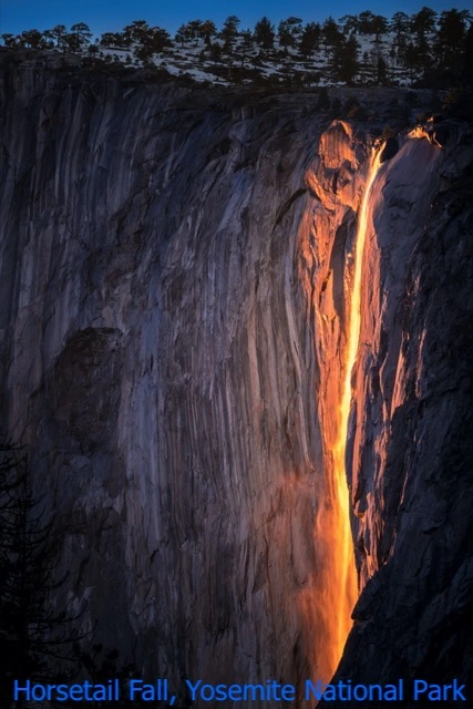
- Horsetail Fall, 1,000ft (304m): This waterfall is famous for reflecting the sun's orange glow at sunset hours in mid-February. It is located east of El Capitan. Flows from December to April.
- Bridalveil Fall, 620ft (189m): It is the first waterfall visitors see when entering Yosemite Valley. This fall flows all year. You can see it up close if you hike the Bridalveil Fall Trail.
- Nevada Fall 594ft (181m): It is at Glacier Point and flows all year. It has a wheelchair-accessible trail, but it closes in winter. If you continue its trail, you will reach Vernal Fall.
- Vernal Fall 317ft (96m): This waterfall flows all year, although it dwindles in late summer.
- Illilouette Fall, 370ft (112m): This waterfall is visible while hiking to Vernal Falls. The best way to see it is by hiking Panorama Trail. This fall is not visible from the road. Flows all year.
- Wapama Falls 1,400ft (426m): This waterfall is not in Yosemite Valley; it is located in Hetch Hetchy Valley. To see it, you need to walk an uneven trail. Flows all year.
- Chilnualna Falls, about 2,200ft (670m): This waterfall is not in Yosemite Valley; it is located in Wawona. This fall twists and turns in the rock. You cannot see it from the road. You need to walk a steep trail. Flows all year long.
If you wish to be close to one of these beautiful features, VRBO has cabins inside and near Yosemite National Park. For locations, dates, and prices, visit this link!
Map of Yellowstone National Park
Yosemite Lakes
There are several lakes surrounded by beautiful scenery in Yosemite Park. Most of them require a hike to be reached.
Some of the lakes in the park are:
- Tenaya Lake: This is the park's largest lake. It has beautiful clear water. The lake may have ice even in the summer. It is popular with visitors for swimming and canoeing.
- Hetch Hetchy Reservoir: This used to be a valley with waterfalls and flowers, but it was converted into a reservoir to supply electricity and water to San Francisco.
- Mirror Lake: Inside the Valley, and famous for its reflection of Half Dome. The lake is marshy unless it is visited in early summer. It is represented as a trailhead on the map.
- May Lake: Popular for picnics.
- Dog Lake: Has peak views.
- Cathedral Lakes
- Sunrise Lakes. Source: My Yosemite
Yosemite Rivers
There are different rivers in the park, but many are seasonal creeks. This is because the melting snow from the Sierra Nevada peaks in spring and early summer.
The park has two watersheds. The Tuolumne River watershed is to the North, and the Merced River watershed is to the South. These watersheds are so predominant that they are the key feature used to create the boundaries of Yosemite National Park.
Therefore, there is a drainage divide in the park produced by peaks.
- Merced River: Flows through Yosemite Valley and is the most iconic river in the park. It can be frozen in winter and calm during summer. Popular activities include fishing and kayaking.
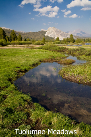
- Tuolumne River: Receives more water than the Merced River. This river is fed by 2 glaciers, and it flows through the Tuolumne meadows. If you hike down the meadows, you will see the river turn into Waterwheel Falls and later into a canyon. Eventually, the river is turned into Hetchy Hetchy Reservoir. Source: My Yosemite Park.
Map of the Smoky Mountains National Park
Wildlife in Yosemite
Yosemite National Park has different ecosystems abounding with life.
Black bears are common dwellers in the park. Finding them is not rare. Therefore visitors need to stay at least 50 yards (45m) away from them. It is advisable to use bear-proof lockers when camping, to avoid deadly encounters.
Other mammals include bighorn sheep, bobcats, marmots, rabbits, ring-tailed cats, squirrels, and mule deer.
The park is also a magnet for birdwatchers. Birds live in the area or pass the park during their migration. Yosemite.
Follow Me
Sources to Make Yosemite Topography Map
The contour lines from Yosemite National Park were downloaded from USGS
The Trail shapefiles were downloaded from NPS
The Road shapefiles were downloaded from Data.gov and California roads
The shapefiles for Yosemite National Park were downloaded from Science Base USGS
The River Shapefiles were downloaded from National Weather Service.
This map will be updated with new data! To receive updates on this and more nature maps, join my email list!!!!!!!
Made by Luz K. Molina with D3.js.