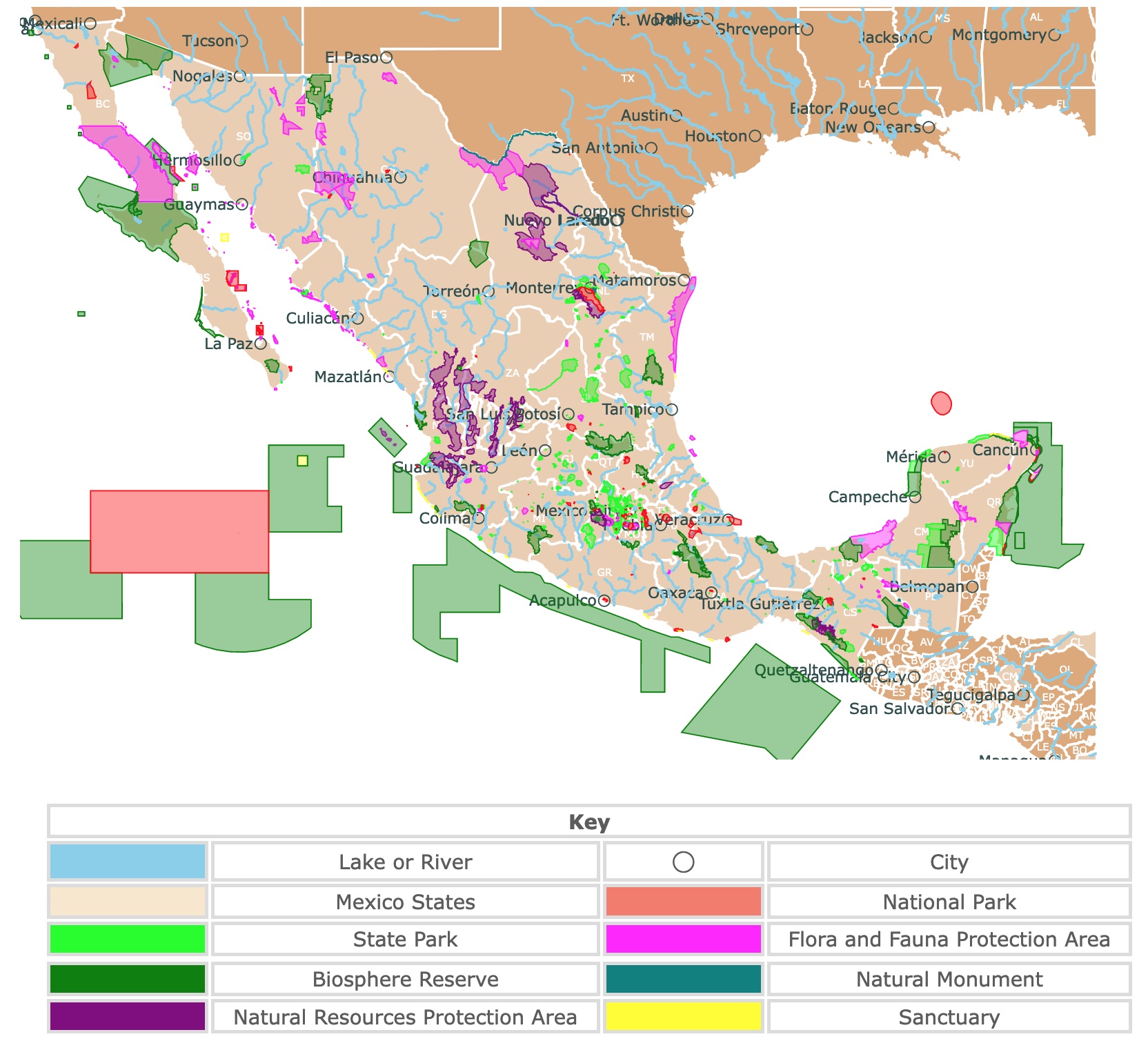
Interactive Map of Mexico's Parks and Protected Areas
This interactive map shows the Locations, Names, and Details of Mexicos National Parks and Biosphere Reserves. It also shows major cities and rivers for context. For more detail, zoom in. For more information, hover over the map, or scroll down.
| Key | |||
|---|---|---|---|
| Lake or River | ◯ | City | |
| Mexico States | National Park | ||
| State Park | Flora and Fauna Protection Area | ||
| Biosphere Reserve | Natural Monument | ||
| Natural Resources Protection Area | Sanctuary | ||
Mexico's Geography
Mexico is situated in North America. It borders the United States to the north, the Gulf of Mexico, and the Caribbean Sea to the east. Belize and Guatemala to the southeast. To the south and the west, Mexico borders the Pacific Ocean.
Temperature is influenced by the time of year, but it is strongly affected by elevation. Lower elevations are warmer than higher elevations.
The Sierra Madre Occidental mountains run north to south from the Sonora-Arizona border to the Sierra Madre del Sur. To the east, there is also the Sierra Madre Oriental. The mountains are steep and are cut by different canyons.
One of these canyons is Copper Canyon, the largest in North America. It is four times larger than the Grand Canyon but narrower, deeper, and greener. This area is just southwest of Chihuahua.
The central Mexican Plateau takes most of central and northern Mexico. A series of volcanoes cross Mexico from east to west. Many of them are still active!
Mexico has over 150 rivers. Most of them are unnavigable, and two-thirds drain into the Pacific Ocean.
Mexico's environment ranges from desertic to wetlands to lowland tropical forests to alpine forests. There are also incredible beaches, mangrove forests, and coral reefs.
Mexico has over 120 million inhabitants, with 20 million living in the capital. The other large majority live in its metropolitan areas.
To learn more about Mexico's people, don't miss this book on Amazon: Mexico - Culture Smart!: The Essential Guide to Customs & Culture. It describes the dynamics of daily life and culture in Mexico!
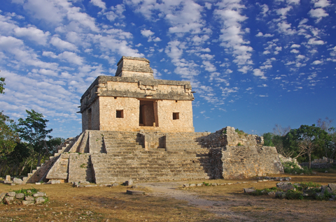
Map of Yucatan Cenotes
Best National Parks of Mexico
Mexico has 67 National Parks, 44 Biosphere Reserves, 41 Flora and Fauna Protected Areas, 18 Sanctuaries, 9 Natural Resource Protection Areas, and 5 Natural Monuments.
They are all displayed on the map above.
Mexico is a magnet for tourists worldwide. It is no secret that some of the prominent locations visitors seek are its sandy beaches and shores.
The most sought-after locations include the Yucatan Peninsula Beaches and Parks, the Cenotes in Yucatan, and the Marine parks from Baja California.
The parks mentioned below are some of the most spectacular outside the Yucatan Peninsula and Baja California.
Islas Marietas National Park
These islands are 35Km from Puerto Vallarta. The map shows the tiny red dot on the Pacific Ocean, west of Guadalajara. You might need to zoom in on the map to find it.
Islas Marietas are uninhabited islands. They are not well known but recognized by their hidden beach. The hidden beach is inside a crater! It was created by military testing before the 1960s.
Access to the hidden beach depends on the tide, wind, and waves.
The islands are also recognized as a birder's paradise. It is home to blue-footed boobies as well as many seabird species.
The islands are encircled by a marine sanctuary. The islands are surrounded by tropical fish, sea turtles, and giant manta rays.
Besides beach-going, there is also whale watching, bird watching, and diving.
Don't hesitate to get this book from Amazon for more information on Puerto Vallarta and its surrounding areas. Puerto Vallarta, Mexico with Sayulita and Riviera Nayarit: The Solo Girl's Travel Guide. This is a full-color travel guide with information to avoid tourist traps, have the best adventures, and find the best beaches!
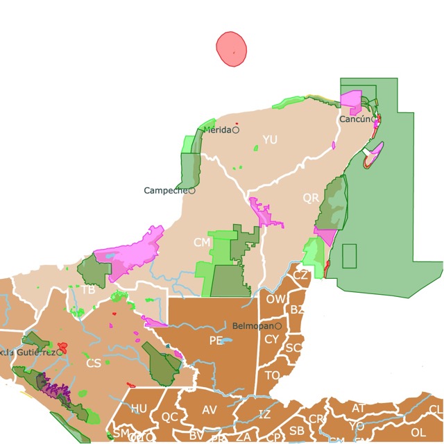
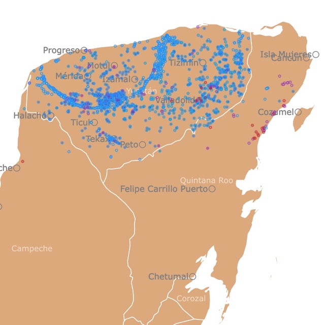
Parks of Yucatan Map
Iztaccíhuatl–Popocatépetl National Park
Also known as Izta-Popo, this is Mexico's oldest national park. This park is the red area just southeast of Mexico City.
Tourists come to admire the two impressive snow-capped volcanoes. Visitors also come to camp, hike, climb, or view the local wildlife.
The park has pine forests and grasslands. There are also grey foxes, lynxes, white-tailed deer, coyotes, opossums, badgers, and the volcano rabbit; Tripsavy.
For more tips and incredible sites, Amazon has a book about Mexico's must-see locations. Lonely Planet Mexico (Travel Guide) has the most relevant, up-to-date advice on what to see and skip while you visit. It has color maps, highlights, and amazing photos!
Lagunas de Montebello National Park
Lagunas de Montebello is the red area in southern Mexico, next to the border of Guatemala.
The area has over 50 lakes. Half in Mexican territory and half in Guatemala's territory.
Not far from the lakes, there are Maya ruins worth visiting. Nevertheless, the true gem is the lakes themselves. They have cyan blue waters surrounded by mountains, coniferous and cloud forests.
The average temperature is 74.5°F (23.6°C), with very rainy summers. The altitude of the lakes is 4,921ft (1,500m) above sea level.
Tourists can swim or rent small boats while visiting the lakes.
This is a biological corridor with 277 species of birds, 65 species of mammals, and 35 reptile species. Nevertheless, what stands out, are the 50 species of orchids and the significant number of ferns! Source: https://en.unesco.org/biosphere/lac/lagunas-montebello.
Pico de Orizaba
Also known as Citlaltépetl, Pico de Orizaba is southeast of Mexico city, on the border of Puebla and Veracruz.
This is a snowcapped volcano, and at 18,491 feet (5,636m), it is one of the world's most pronounced peaks.
Courageous climbers reach the summit every year. The most popular time to climb is around Christmas since other months are too cold or rainy; Culture Trip.
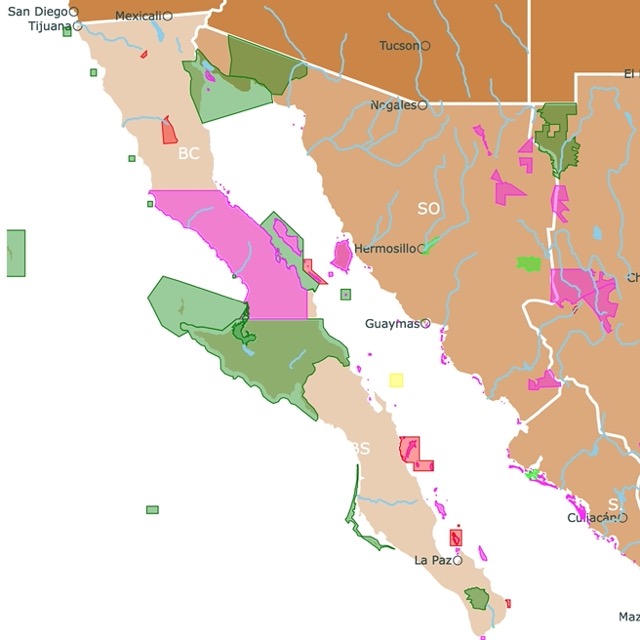
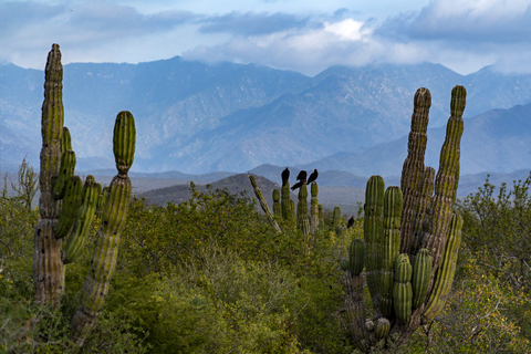
Parks of Baja California
Parque Nacional Canoñon del Sumidero
This national park is located in the state of Chiapas in the southeastern end of the country. It is a jewel among Mexico's National Parks.
This canyon was carved by the Rio Grijalva. With the construction of the Chicoasen hydroelectric dam, the river is now deeper. The stone walls on its sides are impressive, with 2,500 feet (762m) above the river.
Visitors can enjoy the canyon from vantage points or have a 2-3 hour round trip on a boat.
Parque Nacional Canoñon del Sumidero has an ecological park where visitors can view its wildlife, kayak, and enjoy sports activites; Mexperience.
Besides the impressive canyon, there are also beautiful caves, including the Cave of colors with gorgeous pink tones. Another must-see is the Christmas tree or the 2460 feet (750m) high limestone formation with a 656feet (200m) waterfall!
Cumbres de Monterrey National Park
Cumbres de Monterrey is Mexico's third-largest National Park. The park is just south of the U.S. state of Texas.
This park dominates the views from Monterrey. Monterrey is Mexico's third-largest city.
The park contains 72 named mountains that are part of the Siera Madre Oriental. The highest mountain is Cerro La Mota, 11,227ft (3,422m) above sea level.
The park is known for its karst topography. In fact, there are hundreds of caves and underwater rivers throughout the area!
This gorgeous mountain park produces 50% of the water used in Monterrey. It holds coniferous forests, oaks, and scrub. It is also an important conservation area for birds.
Mammal species in the park include raccoons, badgers, coyotes, opossums, mountain lions, wild boars, armadillos, and white-tailed deer; UNESCO.

If you want to learn more about the Pacific Coast, visit North America's Marine Ecoregions Map
FOLLOW ME
Resources for Mexico's National Parks Map
The shapefiles with Mexico's Northwestern Region state boundary lines, major rivers, lakes, and cities were downloaded from Natural Earth Data.
The shapefiles with Mexico's National Parks and State Parks were downloaded from CONABIO at http://www.conabio.gob.mx/informacion/metadata/gis/anpe09gw.xml?_xsl=/db/metadata/xsl/fgdc_html.xsl&_indent=no.
This map will be updated with new data! To receive updates on this and more nature maps, join my email list!!!!!!!
Made by Luz K. Molina with D3.js.