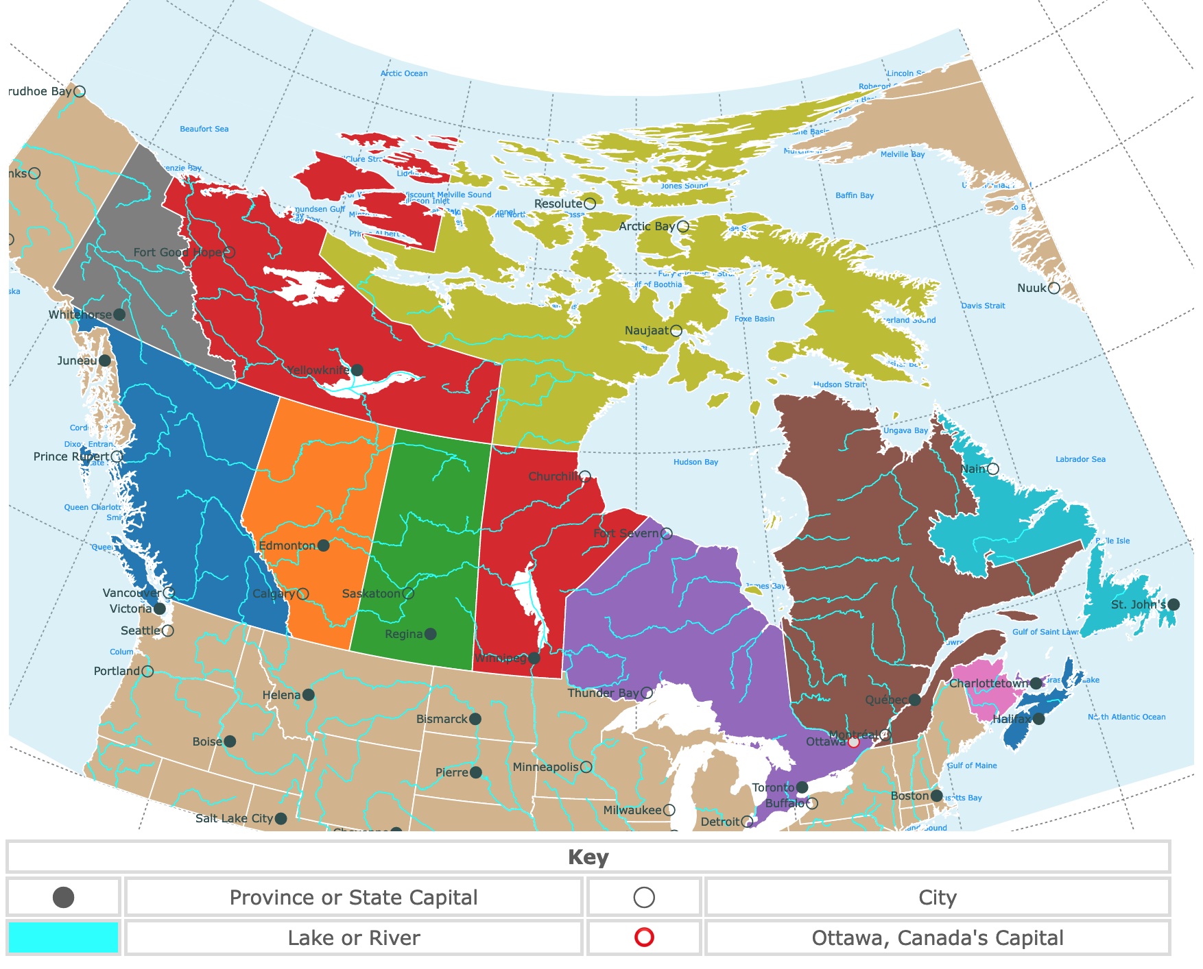
Map of Canada
This is an interactive political map of Canada. It displays provinces, rivers, lakes, and cities. Hover over the map for river names and details. To take a closer look, zoom in. For more information, scroll down.
| Key | ||||
|---|---|---|---|---|
| ⬤ | Province or State Capital | ◯ | City | |
| Lake or River | ⭕ | Ottawa, Canada's Capital | ||
CANADA
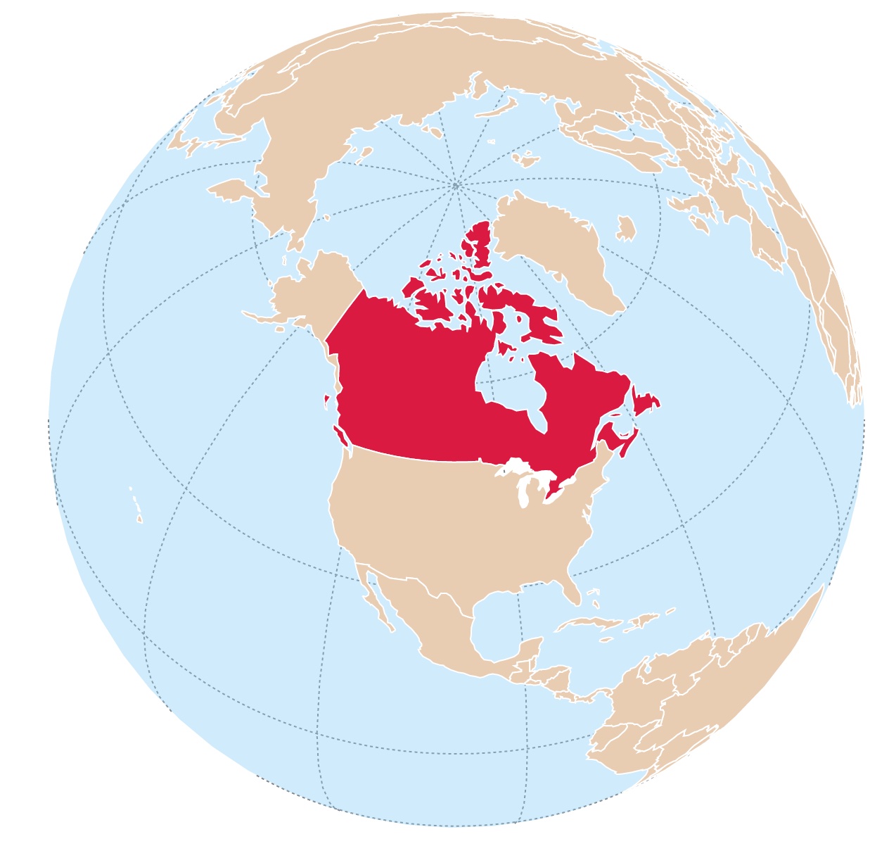
Canada is a country located in North America. It is the second-largest country in the world by land area, covering approximately 9.98 million square kilometers.
Canada is bordered by the United States to the south, with Alaska to the west across the Bering Strait.
It is surrounded by the Atlantic Ocean to the east, the Pacific Ocean to the west and south, and the Arctic Ocean to the north.
If you wish to learn more about Canada, Amazon has A History of Canada in Ten Maps: Epic Stories of Charting a Mysterious Land. This book looks at the mysterious land that would eventually be called "Canada" through the eyes of the explorers that first set foot on its shores.
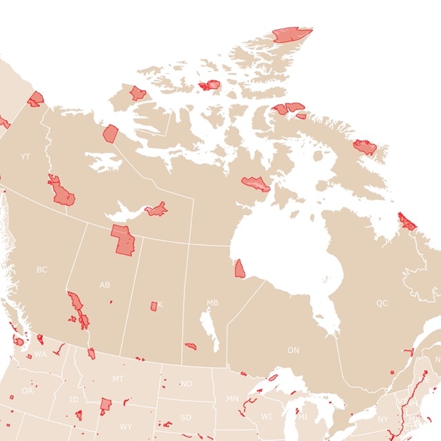
Map of Canada's National Parks
Canada's Geography
Canada's geography is incredibly diverse, featuring many landscapes and natural features. These are some key aspects of Canada's geography:
- Canadian Shield: The Canadian Shield is a large area of exposed Precambrian rock covering about half of Canada. It is characterized by rugged terrain, numerous lakes, and dense forests.
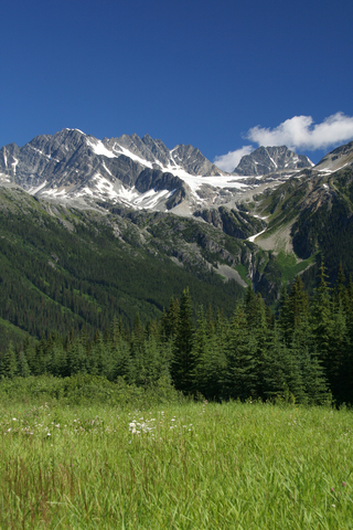
- Rocky Mountains: The Rocky Mountains extend through western Canada, parallel to the Pacific coast. This mountain range is known for its majestic peaks, deep valleys, and stunning alpine scenery.
- Great Lakes: Canada shares a border with the United States along the Great Lakes, which consists of Lake Superior, Lake Huron, Lake Erie, Lake Ontario, and Lake Michigan. These lakes are essential for transportation and offer recreational activities and scenic beauty.
- Coastal Regions: Canada has extensive coastlines along the Atlantic Ocean to the east and the Pacific Ocean to the west. These coasts are characterized by rugged cliffs, picturesque fjords, and beautiful beaches.
- Prairie Region: The prairies, located in the central part of Canada, consist of flat or gently rolling plains. This region is known for its fertile soil and significant agricultural area.
- Arctic Region: The northernmost part of Canada is in the Arctic region, which includes the Arctic Archipelago and the mainland Arctic. It is characterized by vast tundra, permafrost, and Arctic ice caps.
- Boreal Forest: Canada has one of the largest boreal forests in the world, covering a significant portion of its land area. These forests are home to a diverse range of plant and animal species.
- Rivers and Lakes: Canada has numerous rivers and lakes, including the St. Lawrence River, Mackenzie River, Yukon River, and the Great Bear Lake. The country is also known for its vast freshwater reserves.
Canada's Provinces and Territories
Canada is divided into ten provinces and three territories.
| Province name | Capital city |
|---|---|
| Alberta | Edmonton |
| British Columbia | Victoria |
| Manitoba | Winnipeg |
| New Brunswick | Fredericton |
| Newfoundland and Labrador | St. John's |
| Nova Scotia | Halifax |
| Ontario | Toronto |
| Prince Edward Island | Charlottetown |
| Quebec | Quebec City |
| Saskatchewan | Regina |
| Territory name | Capital city |
| Yukon | Whitehorse |
| Nunavut | Iqaluit |
| Northwest Territories | Yellowknife |
Canada is divided into ten provinces, each with its own distinct characteristics, culture, and geography.
Alberta
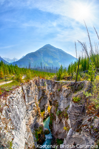
Located in western Canada, Alberta is known for its stunning Rocky Mountain landscapes, including Banff and Jasper National Parks.
This province is rich in oil, gas, and mineral resources and has a strong agricultural sector.
British Columbia
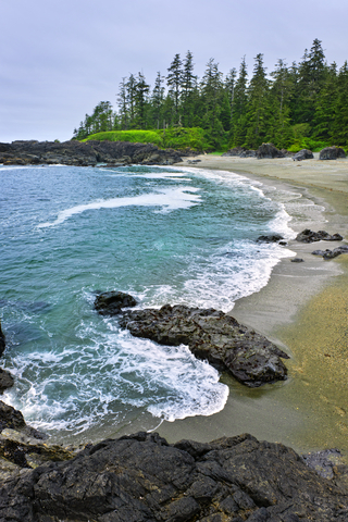
Situated on the Pacific coast, British Columbia offers a diverse geography, including mountains, forests, and coastal regions.
It is renowned for its outdoor recreational activities, vibrant cities like Vancouver, and cultural diversity.
British Columbia is home to 6 National Parks and 400 provincial parks!
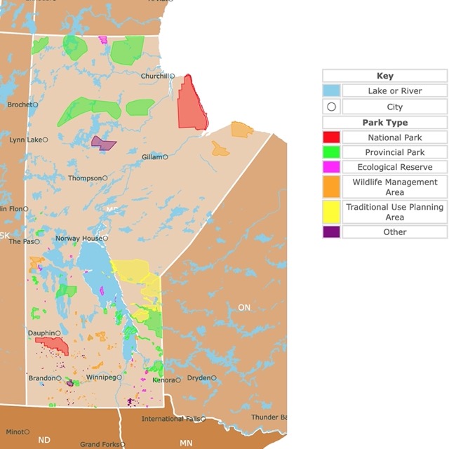
Map of Manitoba's Parks
Manitoba
Located in the heart of Canada, Manitoba is known for its prairies, lakes, and boreal forests.
Winnipeg, the capital city, is a cultural hub, and the province offers opportunities for agriculture, hydroelectric power, and wildlife viewing.
Manitoba has over 100,000 lakes and waterways. Ideal for outdoor enthusiasts and anglers.
Wapusk National Park in northern Manitoba is the world’s largest denning site for polar bears.
New Brunswick
Located in eastern Canada, New Brunswick is the only officially bilingual province in the country, with English and French as its official languages.
It features beautiful coastlines, dense forests, and vibrant cities like Fredericton and Saint John.
The Bay of Fundy in New Brunswick has the highest tides on earth!
Newfoundland and Labrador
Situated on the eastern edge of Canada, Newfoundland and Labrador are known for their rugged coastlines, icebergs, and fishing heritage.
St. John's, the capital, is the easternmost city in North America.
Nova Scotia
Surrounded by the Atlantic Ocean, Nova Scotia offers picturesque coastal landscapes, historic sites, and vibrant cultural traditions.
Halifax, the capital city, is known for its maritime history and lively arts scene.
Ontario
The most populous province in Canada, Ontario, is home to the country's largest city, Toronto.
It offers a diverse range of landscapes, including the Great Lakes, Niagara Falls, and the Canadian Shield.
Ontario is a major economic and cultural hub.
Planning a trip to Canada? Expedia can help! Type the location, and Expedia will give you the best prices.
Prince Edward Island
This small island province is known for its red-sand beaches, charming coastal villages, and agricultural landscapes.
It is the birthplace of the famous novel "Anne of Green Gables" and offers a relaxed island lifestyle.
Quebec
As Canada's only predominantly French-speaking province, Quebec has a distinct culture and heritage.
It features vibrant cities like Montreal and Quebec City, picturesque countryside, and the scenic St. Lawrence River.
Saskatchewan
Located in the prairie region, Saskatchewan is characterized by vast open spaces, fertile farmland, and mineral resources.
It is known as the "Land of the Living Skies" due to its stunning sunsets and expansive skies.
Canada's Territories
Nunavut, Yukon, and the Northwest Territories extend all the way to the Arctic Circle.
They are all places to enjoy the Northern Lights and experience the midnight sun.
Northwest Territories
Yellowknife, the capital of Northwest Territories, is on the shores of Great Slave Lake, one of the largest lakes in the world.
Nahanni National Park in Northwest Territories has the tallest waterfalls in North America.
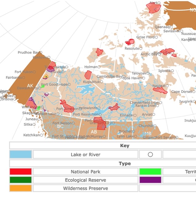
Map of Parks in Canada's Territories
Yukon Territory
The Yukon is home to Canada’s highest peak, largest ice fields, and the smallest desert.
It has an incredible array of wildlife and grizzly bears, caribou, and moose.
Yukon Caribou display the longest mammal migration worldwide!
The Yukon is famous for the Klondike Gold Rush that brought hundreds of thousands of prospectors to the area.
Nunavut
Nunavut is Canada's largest province.
The most common languages spoken are Inuktitut, Inuinnaqtun, English, and French.
About 75% of the world’s narwhal population migrates into Nunavut’s island estuaries and shallow bays.
Follow Me
Resources for Canada's Map
The shapefiles with the provinces, cities, rivers, lakes, and oceans were obtained from Natural Earth.
This map will be updated with new data! To receive updates on this and more maps, join my email list!!!!!!!
Made by Luz K. Molina with D3.js.