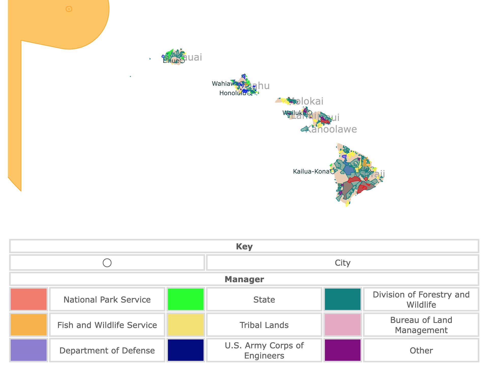
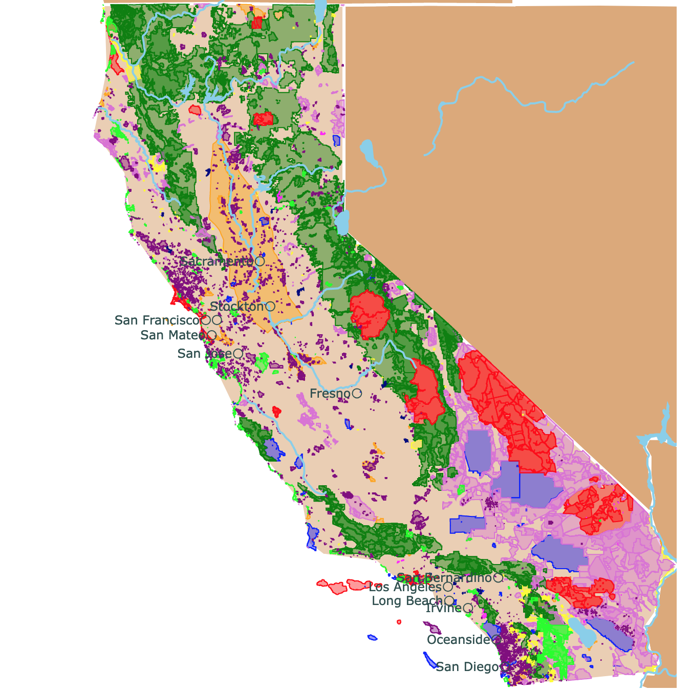
Map of Hawai'i's Parks and Protected Areas
This interactive map shows the Locations, Names, Areas, and Details of National Parks, State Parks, National Forests, Tribal, and other Public Lands of Hawai'i. It also shows major cities and rivers for context. For more detail, zoom in. For more information, hover over the map, or scroll down.
| Key | |||||
|---|---|---|---|---|---|
| ◯ | City | ||||
| Manager | |||||
| National Park Service | State | Division of Forestry and Wildlife | |||
| Fish and Wildlife Service | Tribal Lands | Bureau of Land Management | |||
| Department of Defense | U.S. Army Corps of Engineers | Other | |||
Geography of Hawai'i
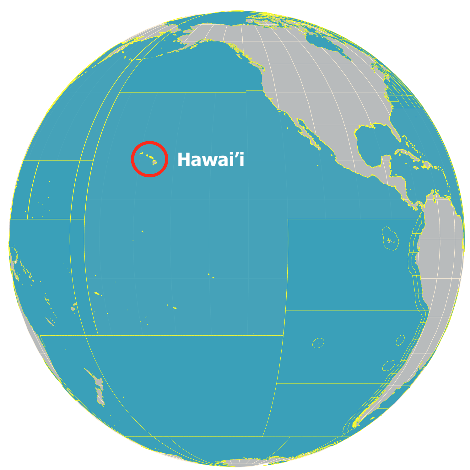
Located about 2300 miles (3680 km) from the nearest continental shore, the Hawai'ian Islands are the most isolated group of islands on the planet.
Hawai'i is the only U.S. state entirely made up of islands. It's the world's largest island chain. However, only seven of the 132 islands are inhabited; Maui, Lanai, Molokai, Kauai, Oahu, Niihau, and Hawai'i or Big Island (as seen on the map).
The Hawai'ian Islands are volcanic islands formed as the Earth's crust moves over a scorching spot in the molten layer beneath the crust.
The extreme heat melts the rock that forms the Earth's crust and turns it into magma. Once the magma breaks through the crust's surface, it cools and creates a new island.
Hawai'i's most active volcano is Kilauea, and it's located on the Big Island at Hawai'i's Volcanoes National Park. According to PBS, Kilauea has been erupting for over 30 years. Every year, the lava expands the state by more than 40 acres.
Hawai'i is well-known for its beautiful beaches. Many of the beaches in Hawai'i are filled with incredible white sand, while some of the state's shores are covered with red, pink, green, or black sand.
One of the interesting environments in Hawai'i is the volcano Mauna Loa. The dry lava from the volcano is very similar to some parts of the moon's surface, so much so that astronauts would walk on it to practice for their lunar voyages.
Hawai'i is the closest state to American Samoa. To learn more about these Pacific Islands, check this map
Hawai'i's Wildlife
Because of Hawai'i's isolation from the rest of the world and infrequent species arrival, Hawai'i is home to many endemic species. That is, species found only in Hawai'i.
While Hawai'i is home to thousands of plants and animals, there is only one land mammal native to the islands, the Hawai'ian Hoary Bat.
Some other mammals in the state include mongooses, feral pigs, and rats. However, these mammals were brought to the area by humans.
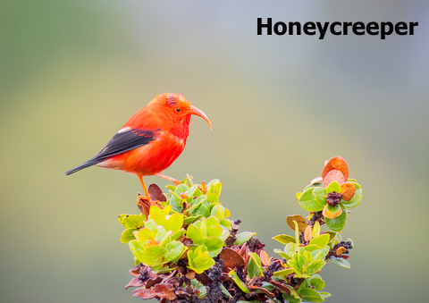
The state is home to native birds like honeycreepers, the Pueo (Hawai'ian owl), the noio (black noddy), and the nene (a relative of Canadian geese).
The oceans are home to incredible sea creatures like monk seals, lizardfish, and hawksbill turtles.
Humpback whales make their way to Hawai'i's waters from December to May for mating, giving birth, and nurturing their calves until they make their way elsewhere.
Many might imagine Hawai'i is as fragrant as beautiful, and they're not wrong. Thousands of species of trees, including perfumed magnolias and plumeria, grow throughout the islands.
Fruit-filled ohi'a 'ai trees can be found on the islands. Hawai'i is home to thousands of flowering plants, including exotic orchids.
Hawai'i's Climate
According to Go Hawai'i, the Hawai'ian Islands experience very consistent weather with minor temperature changes year-round.
Hawai'i only has two seasons: Kau (summer) from May to October and Hooilo (winter) from November to April. Average summer temperatures at sea level are 85℉ (29.4℃), and average daytime temperatures during the winter are about 78℉ (25.6℃).
Nighttime temperatures are approximately ten degrees lower than during the day.
One of the rainiest spots on Earth is Mount Waialeale on the island of Kauai. That area receives an average of 384 inches (32 feet) of rain yearly.

If you want to learn more about the Pacific Coast, visit North America's Marine Ecoregions Map
Hawai'i's Most Beautiful Parks
Hawai'i Volcanoes National Park
Hawai'i Volcanoes National Park is the red area on Hawai'i Island, south of Hilo.
Volcanoes National Park protects some of the most distinctive biological, geological, and highly admired cultural landscapes. The park extends from sea level to 13,681 feet (4,169 meters) in elevation.
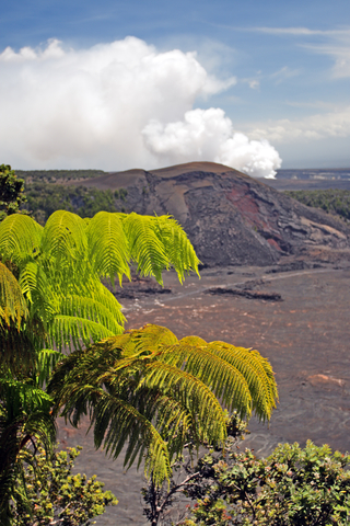
The park encompasses the top of two of the world's most active volcanoes, Mauna Loa and Kilauea. It's a designated International Biosphere Reserve and UNESCO World Heritage Site.
Mauna Loa is the world's largest active volcano and the Kazamura lava tube in the Kilawea is more than 40 miles (64Km) long. It is believed to the longest lava tube globally.
The park has numerous hiking trails to explore, including Pu'uloa petroglyphs, Kilauea Iki, and the Thurston Lava Tube.
Explore 150 miles of hiking trails through volcanic craters, vents, scalded deserts, and rainforests!
Each route is full of interesting natural features and nature. Visitors can also take road or drive tours and explore the land from the comfort of their vehicle.
Hawai'i Volcanoes National Park features two drive-in campgrounds. The Lodge Company operates rustic cabins for overnight guests to spend the night in the comfort of a cabin.
The park has various special programs for visitors to attend. Events like After Dark in The Park and A Walk Into The Past - A Living History, are held at Volcano Park. The events and programs change, so keep an eye on the events and program calendar; Volcanoes.
Haleakalā National Park
Haleakalā National Park is the red area on Maui, south of Wailuku.
This National Park carries many stories of the ancient and modern Hawai'ian culture, protecting the bonds between the land and its people. Furthermore, Haleakala cares for various endangered species, some of which don't exist anywhere else.
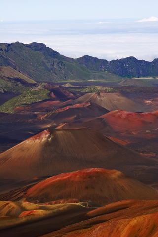
The volcanic landscapes and sub-tropical rainforest provide a picturesque and unforgettable experience while hiking through the backcountry.
One of the jewels of the park are its birds. Here it is possible to see the Honeycreepers, a unique group of forest birds found only in Hawai’i.
The park could be divided into two main districts:
Summit District
This district is focused on the Haleakalā volcano. Here it is possible to hike to the summit or through the cinder desert.
There are several trails to explore, ranging from 0.04 miles up to the popular 11-mile trail. Horses, donkeys, and mules are permitted on all trails as pack animals, but visitors must remove any waste their animals leave behind.
If you're looking for raw beauty, make a reservation to see the sunrise. While you're at it, you can enjoy a beautiful night of stargazing in the park.
Spend a night or more at one of the district's campgrounds. The Hosmer Grove Campground offers six primitive sites with a picnic table, grill, and access to potable water.
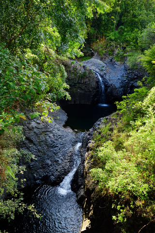
Kīpahulu District
In the Kīpahulu District visitors, can hike to the waterfalls and the coast.
Be prepared for a wet and hot area, but know that you cannot swim due to safety concerns.
The Kipahulu Campground features 21 sites, including five walk-ins, 15 drive-in sites, and one group site. Lastly, visitors can experience wilderness tent camping; Kīpahulu
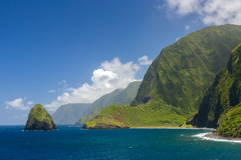
Nāpali Coast State Park
Nāpali Coast State Wilderness Park is the lime strip north of Kauai Island.
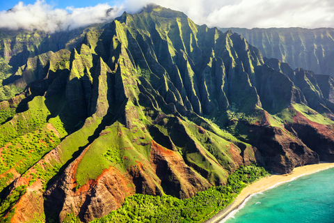
The Nāpali Coast is one of the most impressive coastlines on Earth. The Pali or cliffs provide a rugged backdrop with deep, narrow valleys that end abruptly at sea.
Beautiful waterfalls and folwing streams cut the narrow valleys while the ocean carves the pali.
Hiking, camping, boating, and swimming are only a few of the outdoor recreation opportunities waiting to be had.
It is possible to access the coast by water, renting a motorized boat or Kayak. These tours include snorkeling, lunch, and a guided tour through an archaeological complex.
Kayak is only permitted in the summer, as in other seasons, the seas and wind are too strong. Rented kayaks are available through outfitters on the island.
Camping is permitted, but campers must acquire a camping permit; the permits tend to sell out months in advance, especially during the summer months; Nāpali.
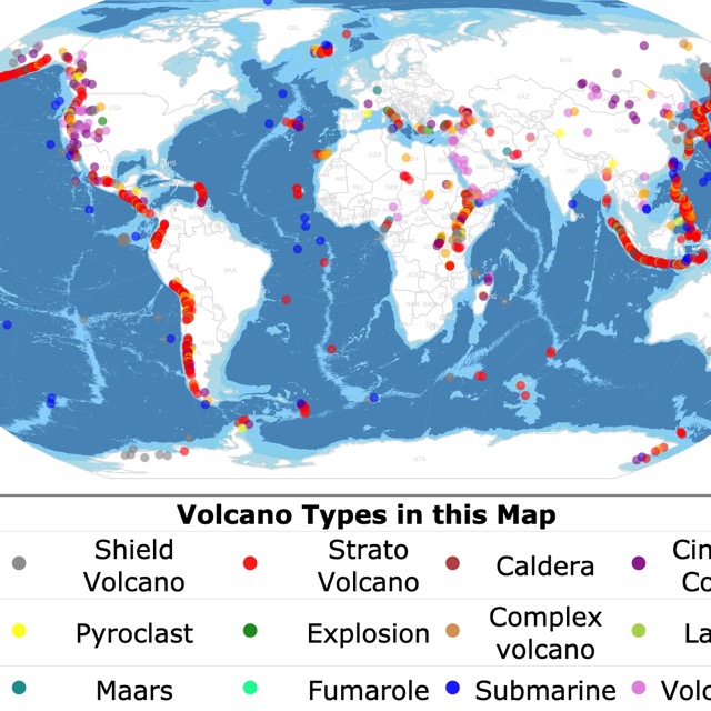
Interested in learning more about volcanoes and their classification? Visit this map
Hāpuna Beach State Recreation Area
Hāpuna Beach State Recreation Area is the tiny lime speck on the northwest side of Hawai'i Island.
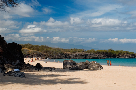
Imagine traveling down a volcanic coastline of the Kohala Coast, following signs that lead to an incredible oasis. Hāpuna Beach has the most renowned white sand beaches in Hawai'i. This area has earned the title of one of Big Island's finest beaches..
The white sands extend during the summer months when the waves recede, and the sea is calm. Sometimes the beach splits into two, revealing lava rocks usually hidden in the cliffs!
Swimming, bodyboarding, sunbathing, snorkeling, and fun in the sun await visitors year-round. If you arrive early in the year, you might catch a glimpse of the migrating whales.
Visitors will find ample parking, barbeque areas, tables, pavilions, food vendors with delicious menus, restrooms, and showers; Hāpuna Beach.
Ka'ena Point State Park
Ka'ena Point State Park is a lime speck on the westernmost tip of Oahu Island.
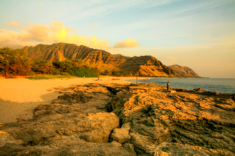
Kaena Point State Park is a lava shoreline that wraps around the northwest corner of the beautiful island of Oahu. The only way to reach the park is by hiking. The round trip is about 5 miles (8Km).
The park has two sections: the Ka'ena Point Keawa'ula Section on the west side of Oahu and the Ka'ena Point Mokuleia Section on the island's north shore.
You will find native animals, tide pools, and the beautiful Pacific Ocean as you hike.
This remote and wild coastline park is excellent for hiking, picnics, and shoreline fishing. Remember to bring your own water, as the park has no water fountains!
The park is a gateway to Ka'ena Point Natural Area Reserve. The large sandy beach is perfect for expert board and body surfers. Swimming is allowed in the summer, but only during calm conditions.
The park is never crowded. Local surfers like to come in the winter months to get some thrills from the high surf! The rocky ocean bottom, strong currents, and high waves can be dangerous, especially for beginning surfers.
Dolphin sightings can take place from the point near Kaluakauila stream mouth. The sea cave, Kaneana, the legendary home of Nanaue (the shark man), can be viewed; Ka'ena.
Interested in learning more about waterfalls? Visit this map
Ahupuaʻa ʻO Kahana State Park
Kahana Valley State Park is the lime area northeast of Oahu Island, 26 miles from beautiful Honolulu.
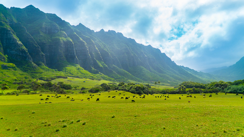
Ahupua'a 'O Kahana State Park is a relatively untouched valley. One of only a few publicly owned ancient Hawai'ian land divisions (ahupua'a) in the state.
This is a living park where native families nurture and foster Hawaiian cultural traditions.
The ancient land of Kahana encompasses nearly 5,300 acres that range from sea level at Kahana Bay up to 2,670 feet on the crest of the Ko'olau Mountains. Kahana is considered one of the wettest valleys on the island of O'ahu, so come prepared for rain.
The trails at the valley may be muddy but easy, passing through rainforests and with beautiful coast views.
Visitors can enjoy beach activities, biking, fishing, camping, hiking, sightseeing, and hunting with the proper permits and licenses. Dogs are allowed at the park, but they must remain on a leash during the visit; Kahana.
Waianapanapa State Park
Waianapanapa State Park is the lime speck east of Maui Island.
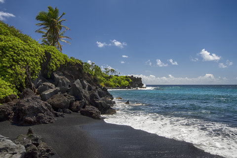
Visitors love this park because of the black beaches, thanks to the volcanic sediment, pebbles, and rocks that contrast with its blue waters and vibrant jungle.
The park trails also lead to freshwater caves with pools where visitors can swim.
Nature lovers and bird enthusiasts have an opportunity to view seabird colonies. The stone arch, native Hala forest, sea stacks, and blowholes. Visitors can also see the Heiau, a religious temple.
Camping and lodging are available. Picnics, family hikes, and shore fishing are a few of the typical recreational activities at the park. The ancient Hawai'ian coastal trail leads to Hana and makes for an excellent hike.
Come early to avoid the crowds! Waianapanapa
Hawai'i has many marine ecosystems to protect. To learn more, check this map of U.S. Marine Protected Areas
Kalaupapa National Historical Park
Kalaupapa National Historical Park is the red area on Molokai Island.
Molokai Island is 38 miles long and 10 miles across but is home to the world's highest cliffs and the longest continuous fringing reef.
The sheer cliffs on Kalaupapa National Historical Park overlook the Pacific, measuring 3,600 feet (1,097m).
The only ways to access the park are by mule, hiking, or airplane.
This Historical Park has an unfortunate history. According to Hawai'i.edu, Hansen's disease (leprosy) was first diagnosed in Hawai'i in 1848.
Supposedly, King Kamehameha V had banished all people afflicted with leprosy to the isolated peninsula, Kalaupapa, on the north shore of Molokai.
Over 8,000 people (primarily Hawai'ians) have died at Kalaupapa since 1866. History shows us that while Kalaupapa was once a prison, it is now a refuge for the few residents remaining who are cured yet forever banished.
The park offers two tours, the Kekalua Tour, a mule ride tour, and Saint Damien & Marianne Cope Molokai Tours. Both tours are owned and operated by patient residents on the island and offer Kalaupapa and Kalawao daily tours.
Camping is prohibited at the Historical Park. In fact, there aren't any overnight accommodations at the park. However, there are camping facilities at Pala'au State Park (lime area southwest of Kalaupapa).
Besides its historical and cultural significance, the park has a unique beaty and natural treasures. The park is home to 30 threatened species. Its waters are home to green sea tutrles, monk seals, and humpback whales.
Visitors can come to meet the last survivors on the island and tour the area; Kalaupapa.
Pearl Harbor National Memorial
Pearl Harbor is the blue area on Oahu Island, west of Honolulu.
The Pearl Harbor National Memorial is where visitors can learn about one of the most profound and crucial moments in the United State's history.
In December of 1941, the Japanese made a surprise aerial attack that resulted in the United States' entry into World War II.
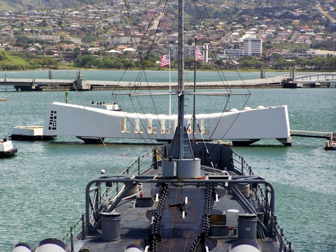
The National Memorial is a unit of the National Park Service that offers guests a place to connect to international, national, and personal histories of the events during World War II.
It is a place of remembrance and contemplation of the unfortunate nature of war and all of the sacrifices of the people who lost their lives during the Pacific War.
Pearl Harbor National Memorial is located adjacent to the Joint Base Pearl Harbor-Hickman.
Visitors come to explore the mostly open-air Pearl Harbor Visitor Center, two world-class museums, the USS Arizona Memorial, USS Utah, and the USS Oklahoma, located on Ford Island.
History lovers come to the memorial to learn more about the history of World War II. There are two exhibit galleries, 'Attack' and 'Road To War.'
The displays feature dramatic photos, personal memorabilia, battle artifacts, and several other exhibits.
Visitors can also visit the Pearl Harbor Memorial Theater to view a documentary on the events and a book store full of information and souvenirs.
Take a peaceful hike to see the Interpretive Wayside Exhibits or join the Remembrance Circle; Pearl Harbor.
California could be your last stop, before flying to Hawai'i. For more parks to explore in California, visit this map
Puʻuhonua O Hōnaunau National Historical Park
Pu'uhonua O Honaunau National Historical Park is the red area on Hawai'i Island, south of Kailua-Kona.
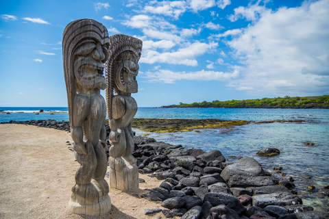
This park's history runs deep. Pu'uhonua was a place of refuge and protection for kapu breakers (kapu is sacred laws), civilians during battle, and defeated warriors.
No harm could befall those who made it to the boundaries of the Pu'uhonua. The only chance of survival for one who had broken kapu was to reach the refuge before their pursuers found them to deliver the ultimate punishment, death.
Cultural demonstrations can be seen almost every day at the park. Demonstrations and storytelling is presented by Kahaka'io Ravenscraft, a descendant of the area and a skilled traditional craftsman.
Hiking is an incredible experience at the park. According to the National Park Service, an ancient trail is now known as the 1871 Trail, which is only a portion of the Ala Kahakai National Historic Trails.
The 175-mile trail extends from the northernmost tip of the island, along the western edge, around the southern border, and into Puna.
Snorkeling is a popular activity in the park and throughout the Big Islands. Visitors come out to "Two-Step" to snorkel in the beautiful waters. Two-Step isn't situated in the National Park, but it's adjacent to it; NPS.
Affiliate Disclosure
Databayou.com is a participant in the Amazon Services LLC Associates Program, an affiliate advertising program designed to provide a means for sites to earn advertising fees by advertising and linking to Amazon.com. Databayou.com also participates in affiliate programs with Clickbank, CJ, and other sites.
If you plan on visiting one of these tropical parks or hiking up the Kilauea, I suggest you get some of these items found on Amazon.
- Snorkel Set: This adult snorkel set comes with a panoramic view and anti-fog goggles. Dive flippers, snorkel, and a bag.
- Waterproof Drybag: This waterproof bag with a dry float sack is ideal for canoeing, kayaking, rafting, and going to the beach.
- Merrell Hiking shoes: These shoes have breathable mesh lining, a protective toe cap, heel cushion, and are light weight.
FOLLOW ME
Resources for Hawai'i's Protected Areas Map
The shapefiles with Hawai'i's state boundary lines, lakes, major rivers, and cities were downloaded from Natural Earth Data.
The Parks and Public Lands shapefiles for Hawai'i were downloaded from USGS.
Reserves data was downloaded from Hawai'i Statewide GIS Program.
This map will be updated with new data! To receive updates on this and more nature maps, join my email list!!!!!!!
Made by Luz K. Molina with D3.js.