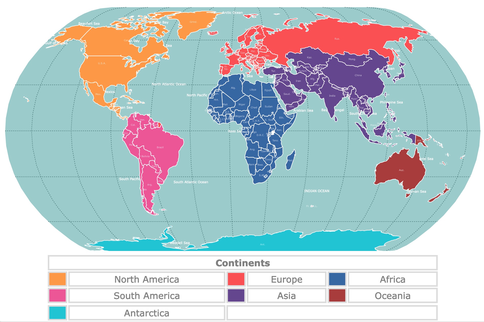
Map of Continents
This map shows the 7 continents in different colors. It also displays countries and their names. For population, GDP, and more, hover over the map. To take a closer look, zoom in. For more information, scroll down.
| Continents | |||||
|---|---|---|---|---|---|
| North America | Europe | Africa | |||
| South America | Asia | Oceania | |||
| Antarctica | |||||
What are Continents?
Continents are determined based on a combination of geological, geographical, and tectonic factors.
It's important to note that there is no universally accepted definition of continents, and the exact number and boundaries of continents can vary depending on different perspectives and regional conventions.
There are seven continents Africa, Antarctica, Asia, Europe, North America, Oceania, and South America.
If you like geography and would like to learn more about the continents, Amazon has the National Geographic Atlas of the World. This 11th edition provides authoritative maps of every country, ocean, and region, as well as thematic maps and accompanying graphics showing important population, environmental, and economic patterns.
The primary criteria for determining continents include the following:
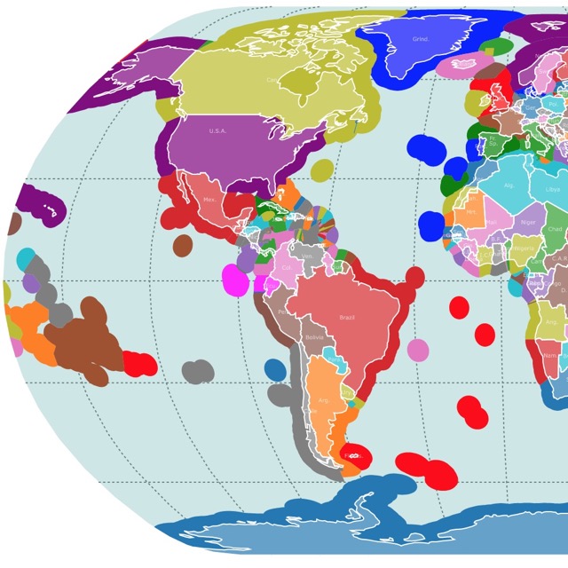
Map of Exclusive Economic Zones Worldwide
Landmass
Continents are typically large, continuous landmasses separated by significant bodies of water, like oceans and seas.
A distinct landmass distinguishes a continent from smaller islands or archipelagos.
Geological Structure
Continents are often composed of thick and stable continental crust, which differs from the thinner and more active oceanic crust.
The continental crust is generally older and contains a variety of rock formations.
Tectonic Crust
Continents are associated with specific tectonic plates.
Tectonic plates are large sections of the Earth's crust that float on the semi-fluid layer below.
Continents are typically located on the portions of these plates known as continental plates.
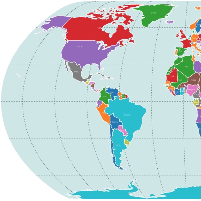
Map of Countries Worldwide
Cultural and Historical Factors
Continents are also determined by cultural and historical factors.
These factors consider human perception and how continents have been traditionally recognized and studied throughout history.
For example, Europe and Asia are sometimes considered separate continents. In others, they are combined into one continent called Eurasia.
Similarly, some classifications consider Australia a separate continent, while others group it with the larger Oceania region.
The Continents
Africa
Africa has an area of 30,365,000 Km2, 11,724,000sq mi. Africa is the second largest continent.
Africa is the most tropical of all continents. Its climate and vegetation range from tropical rainforest to savanna grassland, to tropical desert to Mediterranean.
Africa holds the Sahara, the world's largest tropical desert.
Other interesting facts are that Africa has few navigational rivers, and its coast lacks coastal indentations or inlets like bays or gulfs. All this is compared to different continents. Source: Youtube Facts about Africa.
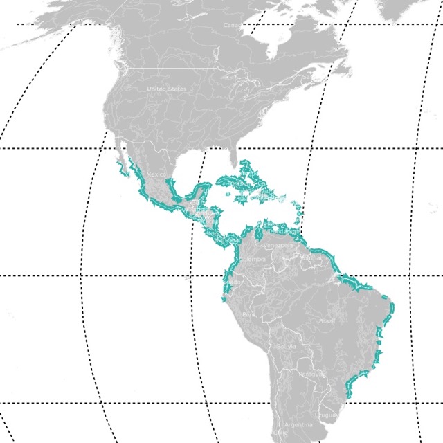
Map of Mangrove Forests Worldwide
Asia
Asia is the largest continent. It has an area of 44,614,000 Km2, 17,226,000 sq mi.
Asia is home to the Himalayas, a mountain range that separates the plains of the Indian subcontinent from the Tibetan Plateau.
The Himalayas hold the tallest mountains, including Mount Everest, the tallest mountain on Earth at 29,031 ft (8,848m) above sea level.
The Asian continent is home to over 4 billion people. That is 60% of the human population.
Due to its size and geography, Asia is an extremely biodiverse continent!
North America
The area of the North American continent is 24,230,000 Km2, 9,360,000sq mi.
North America is the third-largest continent. It extends from the Aleutian Islands in the northwest to the Isthmus of Panama in the south.
North America also includes the island of Greenland and some Caribbean Islands.
This continent is graced with mineral resources, including gold and silver. North America is also a major producer of coal.
Its natural wealth also relies on vast forests, immense quantities of fresh water, and some of the world’s most fertile soils.
These have allowed North America to become one of the most economically developed regions in the world,
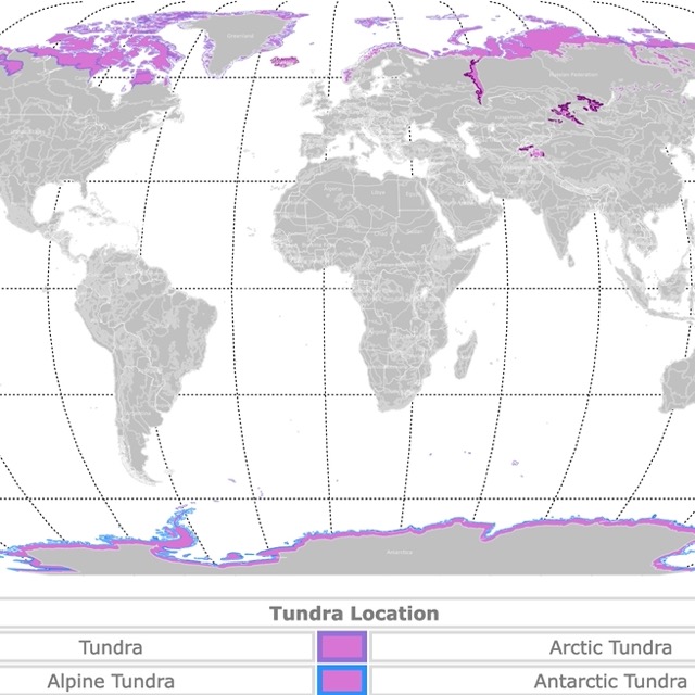
Map of Tundra Biome
South America
South America is the fourth largest continent with 17,814,000 Km 2, 6,878,000 sq mi.
South America is home to the largest tropical rainforest, the Amazon, and home to the largest river, the Amazon River.
It is also home to the driest desert, the Atacama Desert.
South America's major mineral resources are gold, copper, iron ore, tin, and petroleum.
Antarctica
Antarctica has an area of 14,200,000 Km 2, 5,500,000 sq mi.
Antarctica is located over the South Pole. It is an extremely cold continent with high winds and little precipitation.
Antarctica's precipitation is about 2in. per year and is mainly in the form of snow.
Despite this, Antarctica is also the iciest continent and holds the most fresh water in the world.
Plant life is limited to algae, lichens, and mosses.
Animal life is rich with zooplankton, fish, squid, seals, whales, and seabirds. Source: Antarctica.
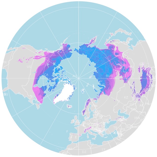
Map of Arctic Permafrost
Europe
Europe has an area of 10,000,000 Km2 3,900,000 sq mi.
Europe's northern location greatly affects its growing season and people's mood. Nevertheless, the influence of the Gulf Stream makes this continent's sesons milder.
Rivers are abundant in Europe and have provided adequate transportation for travel and trade throughout its history.
Europe is a wealthy continent and is the center of the West and Western Democracy.
Europe has been home to various civilizations, including Ancient Greece and the Roman Empire. It is also home to the birth of democracy.
Europe has been the central point of wars and colonization of other continents.
The map above is influenced by social and political factors. Some books will denote that the eastern edge of Europe is the Ural mountains.
But here, Russia, due to historical reasons, is considered European and part of Europe.
Oceania / Australia
Oceania, also known as the Australian Continent, has an area of 8,511,000 Km2, 3,286,000 sq. mi.
This area
Oceania is a geographic region that includes Australia, Tasmania, New Zealand, New Guinea, and the scattered islands of Melanesia, Micronesia, and Polynesia in the South Pacific Ocean.
Most of Australia is a desert with some savannas and forests.
Australia is characterized by unique wildlife. These include marsupials like the koala and the kangaroo. There is also the only living Monotreme, the platypus.
The continent is well known for its coral reefs and the largest coral reef known as the Great Barrier Reef.
Follow Me
Resources for Continents of the World Map
The shapefiles with the countries of the world were obtained from Natural Earth.
This map will be updated with new data! To receive updates on this and more nature maps, join my email list!!!!!!!
Made by Luz K. Molina with D3.js.