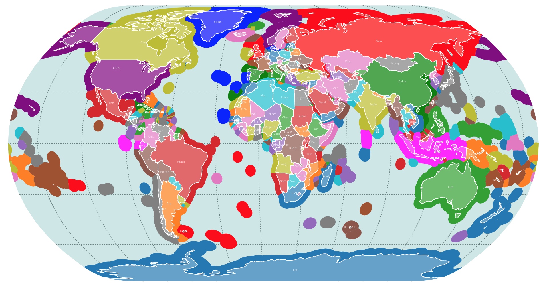
Exclusive Economic Zone Map
This map shows the world's Exclusive Economic Zones and country borders. For country names and territorial waters, hover over the map. To take a closer look, zoom in. For more information, scroll down.
Exclusive Economic Zones
EEZ stands for Exclusive Economic Zones.
It is an area of the sea prescribed by the United Nations Convention on the Law of the Sea (UNCLOS) over which a coastal state has special rights regarding the exploration and use of marine resources.
The EEZ extends up to 200 nautical miles (370 kilometers) from the coastal baseline of a country.
Within the EEZ, the coastal state has exclusive rights to explore and exploit natural resources, including fish, oil, gas, and minerals present in the water column and on or beneath the seabed.
It also has jurisdiction over the management of marine scientific research, environmental protection, and the construction and operation of artificial islands and structures for economic purposes. Source: UN.org.
The establishment of the EEZ provides coastal states with a measure of control over resources in their adjacent waters, while still allowing for the freedom of navigation and overflight by other countries in international waters.
For an indepth explanation of the EEZ, international relations, and its ambiguities Amazon has The Exclusive Economic Zone (Law) by Charles Quince.
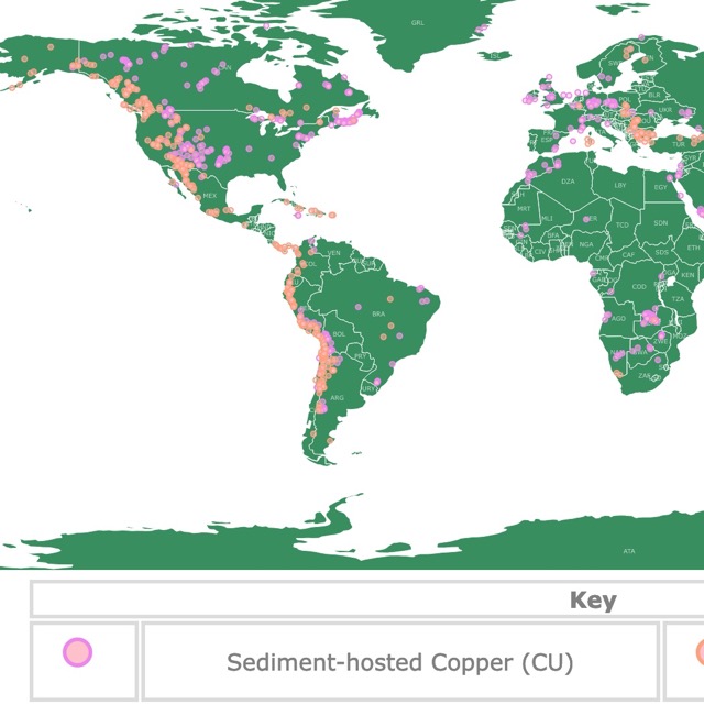
Map of Copper Deposits Worldwide
Facts About EEZ
- Coastal countries retain special rights to exploration and use of marine resources, but the water’s surface remains international territory. Ciel
- The U.S. EEZ is one of the largest in the world, covering 3.4 million square nautical miles, which is larger than the total land area of the United States. NOAA
- EEZs have also been used to determine which country is responsible for removing marine hazards such as space debris. Britannica.com
- EEZs cover about 39% of the world's oceans.
- EEZ's do not affect the rights of other nations to navigate through these waters or conduct scientific research.
History of EEZ
The beginning of Exclusive Economic Zones (EEZs) dates back to the mid-20th century when concerns arose over the exploitation of marine resources and the need for a clear framework to govern the rights and responsibilities of coastal states.
The concept was actually pioneered by Latin American states, such as Chile and Peru, in the 1940s.FAO.org.
Prior to the concept of EEZs, the customary international law recognized the concept of territorial waters.
Territorial waters generally extended up to 3 nautical miles (5.6 kilometers) from the coastal baseline and were considered under the complete sovereignty of the coastal state.
As advancements in technology allowed for greater exploration and exploitation of marine resources, coastal states sought to extend their jurisdiction beyond the traditional territorial waters.
They sought to control larger areas to benefit from the potential economic resources present in the oceans.
The United Nations Conference on the Law of the Sea (UNCLOS), which took place from 1973 to 1982, aimed to establish a comprehensive legal framework for the governance of the world's oceans.
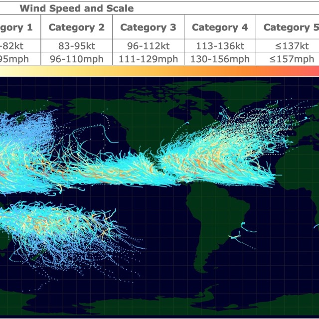
Map of Cyclones and Hurricanes.
The conference resulted in the adoption of the United Nations Convention on the Law of the Sea, which was signed in 1982.
The UNCLOS introduced the concept of Exclusive Economic Zones (EEZs).
The UNCLOS was adopted by many countries and entered into force in 1994.
Today, the vast majority of coastal states have established EEZs based on the provisions of the convention.
However, there are still some countries that have not ratified or fully implemented the UNCLOS.
Over the years, the interpretation and application of EEZs have evolved through legal cases, negotiations, and international practice.
Disputes between neighboring countries over overlapping EEZ claims have been addressed through international tribunals, such as the International Court of Justice (ICJ) or the International Tribunal for the Law of the Sea (ITLOS).
For a critical look at the Law of the Sea, Amazon has Judging the Law of the Sea. Judging the Law of the Sea focusses on how Judges interpret and apply UNCLOS and it explores how these cases are shaping the law of the sea.
EEZ Disputes
There have been several disputes and conflicts related to Exclusive Economic Zones around the world.
These disputes typically arise when neighboring countries have overlapping claims or conflicting interpretations of maritime boundaries.
Disputes over EEZ boundaries can arise between neighboring countries, and are often resolved through negotiation or arbitration.

South China Sea
The South China Sea has been a major hotspot for EEZ disputes involving multiple countries, including China, Vietnam, the Philippines, Malaysia, Brunei, and Taiwan.
The disputes primarily revolve around conflicting territorial claims over islands and reefs, as well as the rights to explore and exploit the region's rich fishing grounds and potential hydrocarbon resources.
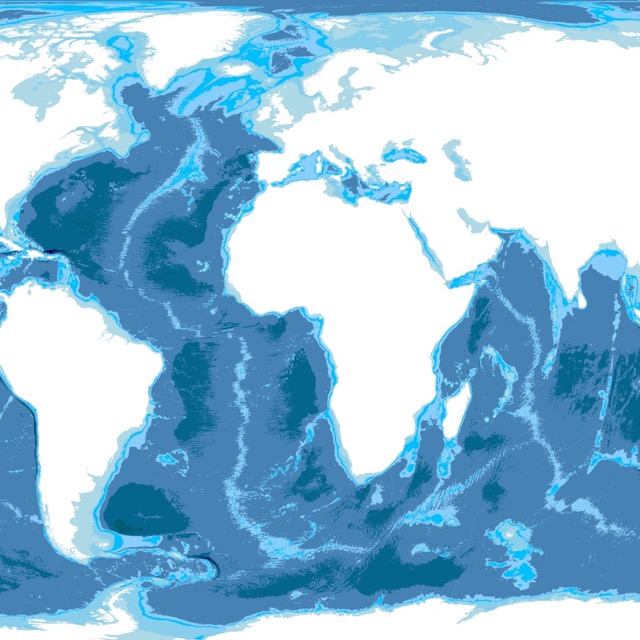
World Bathymetry Map
East China Sea
The East China Sea dispute involves mainly China and Japan. The primary focus is on the sovereignty of the Senkaku/Diaoyu Islands, but it also extends to the delimitation of the EEZs between the two countries.
Both countries have conducted patrols, deployed military assets, and engaged in diplomatic disputes in the region.
Greece-Turkey
Greece and Turkey have longstanding disputes over the delimitation of their respective EEZs in the Aegean Sea and the Eastern Mediterranean.
The conflicts center around territorial claims, rights to explore and exploit hydrocarbon resources, and the delineation of maritime boundaries between the two countries.
India-Pakistan
In Asia, India and Pakistan have overlapping EEZ claims in the Arabian Sea. The dispute primarily focuses on the delimitation of the maritime boundary between the two countries, particularly in the Sir Creek area.
The issue has implications for fishing rights, offshore oil and gas exploration, and security concerns in the region.
To learn more about Policy Perspectives in Deep-Sea Mining Amazon has Perspectives on Deep-Sea Mining: Sustainability, Technology, Environmental Policy and Management.
Peru-Chile
In South America, Peru and Chile had a historical dispute over the maritime boundary in the Pacific Ocean.
The conflict was primarily centered around the delimitation of the maritime boundary and the extent of each country's respective EEZ. In 2014, the International Court of Justice (ICJ) issued a ruling that settled the dispute.
These are just a few examples of EEZ disputes. It's worth noting that some disputes have been resolved through diplomatic negotiations, bilateral agreements, or international legal processes, while others remain unresolved and continue to impact regional tensions and geopolitical dynamics.
EEZ Geography
The geography of EEZs is determined by several factors, including the coastline of a country, the presence of offshore islands, and overlapping claims with neighboring countries.
The starting point for measuring the 200-nautical-mile limit of an EEZ is typically the low-water line along the coast.
However, some countries with irregular coastlines or coastal features like bays and fjords may use a different baseline to calculate their EEZ.
EEZs can extend beyond the 200-nautical-mile limit if a coastal state has islands within that range.
The UNCLOS allows for the "drawing of straight archipelagic baselines" to enclose the islands and their waters as part of the EEZ.
In cases where the EEZs of neighboring countries overlap, maritime boundaries are negotiated or resolved through international law, bilateral agreements, or through specialized tribunals like the International Court of Justice (ICJ) or the International Tribunal for the Law of the Sea (ITLOS).
In enclosed or semi-enclosed seas, such as the Mediterranean Sea or the Gulf of Mexico, the concept of EEZs becomes more complex due to the shared nature of the waters.
In these cases, countries often negotiate joint development agreements or establish regional management frameworks.
If you are interested in learning more about the EEZ, Amazon has The International Law of the Sea. This book presents two paradigms of the law of the sea: the law of divided oceans and the law of our common ocean. It covers contemporary issues, such as protection of the marine biological diversity, marine plastic pollution, the Arctic, and impacts of climate change on the oceans.

Map North America's Marine Ecoregions
Follow Me
Resources for EEZ Map
The shapefiles to create the EEZ map were downloaded from Flanders Marine Institute (2023): MarineRegions.org. Available online at www.marineregions.org. Consulted on 2023-05-30.
The shapefiles with the countries of the world were obtained from Natural Earth.
This map will be updated with new data! To receive updates on this and more nature maps, join my email list!!!!!!!
Made by Luz K. Molina with D3.js.