Map of Mexico
This interactive Mexico map shows cities and roads. Hover over the map to find the population, road, name and type. For more detail, zoom in. For more information, scroll down.
| 🇲🇽 Key 🇲🇽 | |||
|---|---|---|---|
| Lake or Sea | ⚫ | City | |
| Mexico | Mexico's Neighbors | ||
| ▬▬ | Road or Ferry | ||
Where is Mexico?

Mexico is situated in North America. Specifically, it occupies the southern portion of the continent.
Mexico is the northernmost country in Latin America.
It borders the United States to the north, the Gulf of America (Golfo de Méjico), and the Caribbean Sea to the east.
It borders Belize, El Salvador, and Guatemala to the southeast. To the south and the west, Mexico borders the Pacific Ocean.
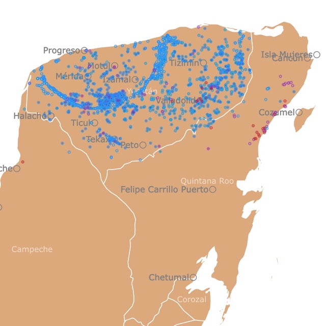
Map of Cancun Cenotes
Mexico Cities
According to the World Bank, it is estimated that Mexico has 129.7 million inhabitants.
Approximately 77% of Mexicans live in cities.
Mexico's Largest Cities and Industry
| City | Main Industry |
|---|---|
| Mexico City | The capital is the political and cultural hub. It is the fifth-largest city in the world. |
| Monterrey | The industrial heart of Nuevo León, Monterrey is Mexico’s second-largest city. It boasts a strong economy driven by manufacturing, commerce, and technology. |
| Guadalajara | The capital of Jalisco ranks as the third-largest city in Mexico and remains a cultural and economic powerhouse in the region. It is renowned for its vibrant tech and service industries and historical significance. |
| Puebla | Puebla is a key player in the automotive and manufacturing sectors. |
| Tijuana | One of the most important border cities. Its proximity to the United States gives it a strategic advantage in international trade. |
| Toluca | Toluca is a major business hub in the State of Mexico. |
| León | León is recognized for its strong leather and footwear industry and its expansion into other industrial sectors. |
| Torreón | Known for its economic growth, particularly in the construction and manufacturing industries. |
| Ciudad Juárez | This city is crucial in manufacturing and cross-border trade. |
| Querétaro | Recognized for its aerospace and technology industries. |
Source: Vynmsa.
Mexico's Roads and Highways
In Mexico, Federal Highways run from north to south and are assigned odd numbers.
Highways go from west to east and are assigned even numbers.
The numbering scheme starts in the northwest of the country in Tijuana, Baja California.
The highest-numbered Mexican Federal Highway is 307. This is the easternmost road on the map. It is the road on the Yucatan peninsula bordering the coast.
The letter "D" (for Directo) is added to the road number for all toll roads.
If you want a more detailed map for a road trip, Amazon has National Geographic's Road Atlas: Adventure Edition.
This is the ideal companion for the next time you hit the road. It includes up-to-date road maps for all 50 U.S. States, plus Canada, Mexico, and Puerto Rico.
Map of Mexico States
This map of Mexico shows Mexico's states and major cities.

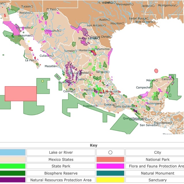
Parks of Mexico Mapped
List of Mexico States, Capitals, and Population
| State | Capital | Population (approximate) |
|---|---|---|
| Aguascalientes | Aguascalientes | 1,425,607 |
| Baja California | Mexicali | 3,769,020 |
| Baja California Sur | La Paz | 798,447 |
| Campeche | San Francisco de Campeche | 1,002,685 |
| Chiapas | Tuxtla Gutiérrez | 5,543,867 |
| Chihuahua | Chihuahua | 3,703,726 |
| Coahuila | Saltillo | 3,146,644 |
| Colima | Colima | 731,391 |
| Durango | Victoria de Durango | 1,832,650 |
| Guanajuato | Guanajuato | 6,166,934 |
| Guerrero | Chilpancingo de los Bravo | 3,540,685 |
| Hidalgo | Pachuca de Soto | 3,082,841 |
| Jalisco | Guadalajara | 8,348,151 |
| Mexico | Toluca de Lerdo | 17,102,000 |
| Mexico City (Federal District) | Mexico City | 9,209,944 |
| Michoacán | Morelia | 4,748,846 |
| Morelos | Cuernavaca | 1,971,520 |
| Nayarit | Tepic | 1,235,456 |
| Nuevo León | Monterrey | 5,784,442 |
| Oaxaca | Oaxaca de Juárez | 4,132,148 |
| Puebla | Puebla | 6,583,278 |
| Querétaro | Santiago de Querétaro | 2,368,467 |
| Quintana Roo | Chetumal | 1,857,985 |
| San Luis Potosí | San Luis Potosí | 2,822,255 |
| Sinaloa | Culiacán | 3,026,943 |
| Sonora | Hermosillo | 2,945,600 |
| Tabasco | Villahermosa | 2,402,598 |
| Tamaulipas | Ciudad Victoria | 3,527,735 |
| Tlaxcala | Tlaxcala | 1,342,977 |
| Veracruz | Xalapa-Enríquez | 8,626,143 |
| Yucatán | Mérida | 2,385,467 |
| Zacatecas | Zacatecas | 1,622,138 |
FOLLOW ME
Resources for Mexico's Map
The shapefiles with Mexico's Northwestern Region state boundary lines, major rivers, lakes, and cities were downloaded from Natural Earth Data.
This map will be updated with new data! To receive updates on this and more nature maps, join my email list!!!!!!!
