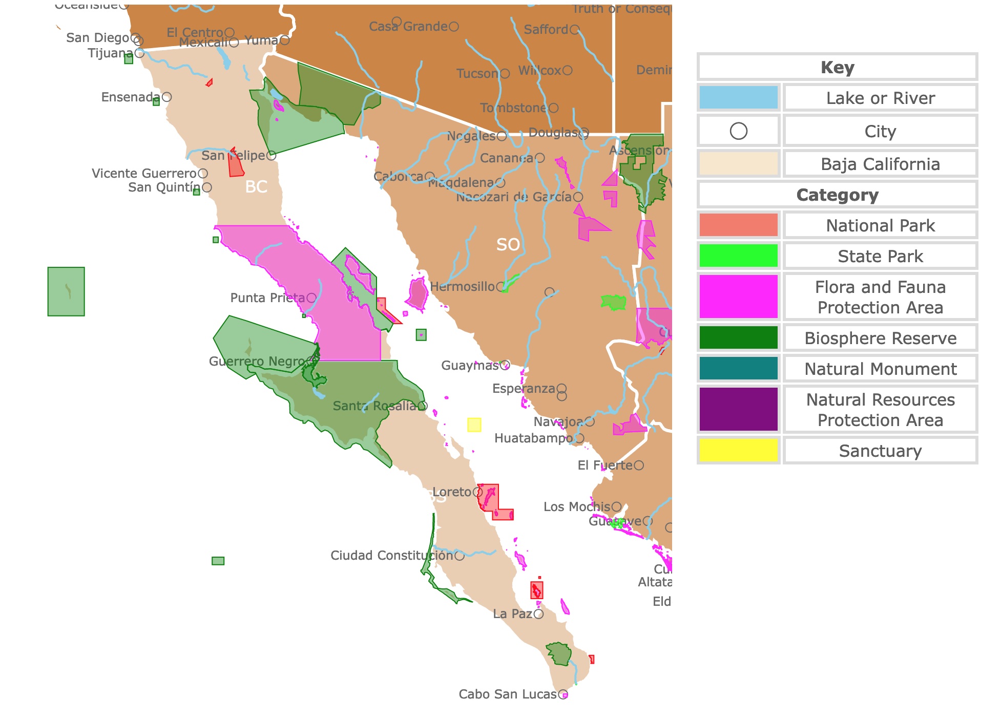
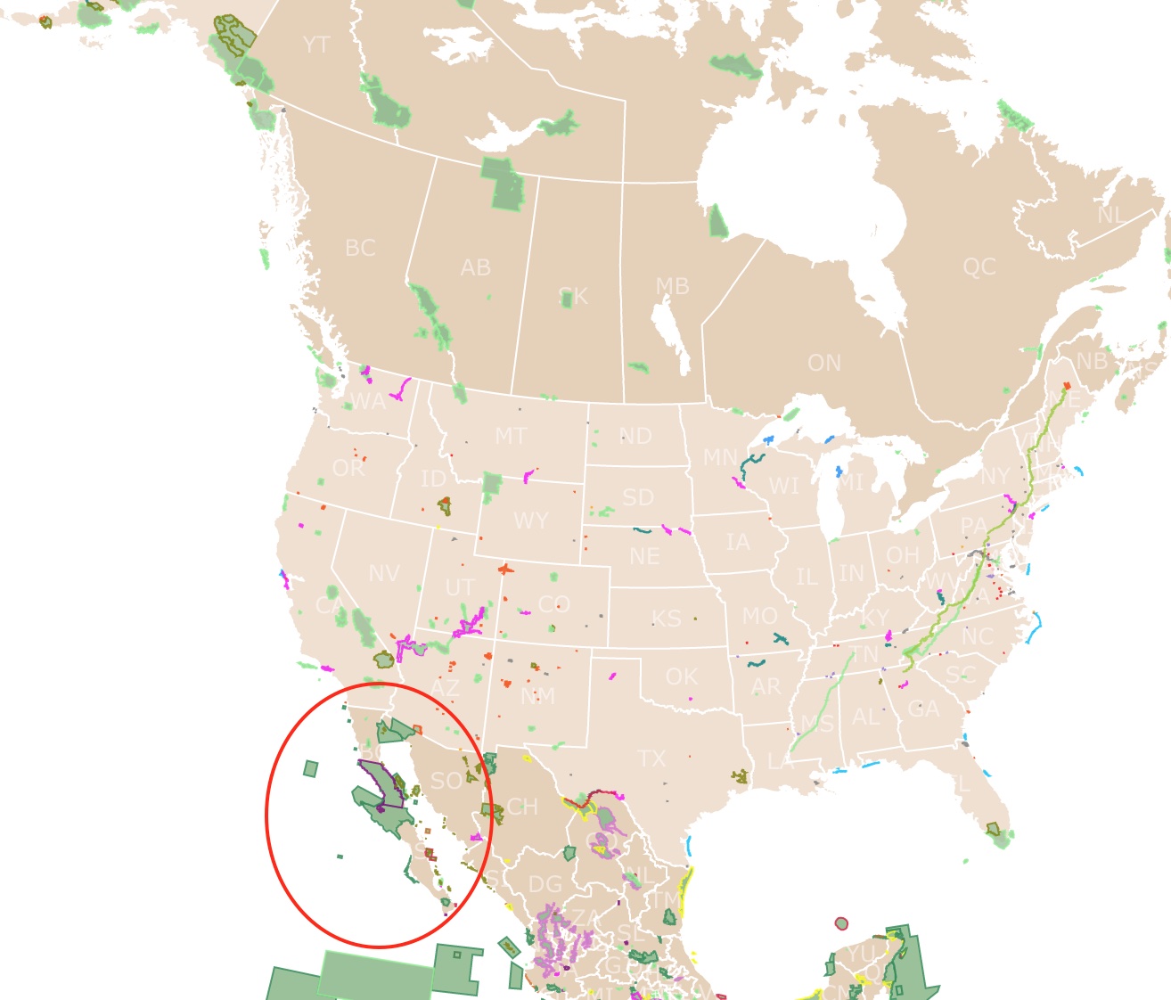
Map of Mexico's Baja California Parks
This interactive map shows the Locations, Names, and Details of National Parks in Mexico's Baja California and Baja California Sur. It also shows major cities and rivers for context. For more detail, zoom in. For more information, hover over the map, or scroll down.
| Key | |
|---|---|
| Lake or River | |
| ◯ | City |
| Baja California | |
| Category | |
| National Park | |
| State Park | |
| Flora and Fauna Protection Area | |
| Biosphere Reserve | |
| Natural Monument | |
| Natural Resources Protection Area | |
| Sanctuary | |
Baja California's Geography
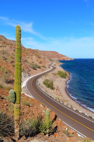
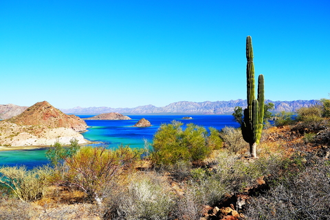
Baja California (Lower California) is a peninsula in northwestern Mexico. Baja California is 760 miles (1,220 km) long and 25 to 150 miles (40 to 240 km) wide. It is divided into two states, Baja California and Baja California Sur to the south.
The peninsula shares a border to the north with California and a slight stretch with Arizona in the U.S.
The eastern edge is bordered by the Gulf of California, also called the Sea of Cortez, and the west by the Pacific Ocean.
The primary geological feature of Baja California is a fault block.
It rises abruptly on the gulf side while dropping gradually into the Pacific and culminating in a chain of rocky peaks in the northwest-southeast direction.
The granitic Juarez and San Pedro Martir mountains form the divide in the north. Within the San Pedro Martir Mountains is "Picacho del Diablo", Baja's tallest mountain at 10,154 feet (3,095 meters) above sea level.
The center of Baja California's peninsula, is dominated by volcanoes and lava flows that extend westward. The Las Tres Virgenes volcano, 6,548 feet (1,996 meters), was last reported active in the 1700s.
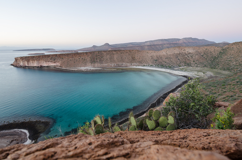
Baja California features 2,038 miles (3,280 km) of incredible coastlines with numerous islands on either side.
The primary water sources for Baja California are the Colorado and Tijuana Rivers. The Colorado River flows to the Gulf of California. Still, because most of it is used for agriculture and drinking water by nearby states, it is rarely reaches the Gulf.
The rest of Baja's water comes from wells and dams, but clean drinking water is a big issue in the region.

If you want to learn more about the Pacific Coast, visit North America's Marine Ecoregions Map
Baja California's Climate
Baja California experiences three zones of climate that determine the region's animal and plant life.
The peninsula's northwest corner experiences cyclonic cold fronts that bring fog and rain during the winter. This area's climate could be described as similar to the Mediterranean.
Heading southward brings us to a very dry and arid zone that extends through the middle of the peninsula to La Paz.
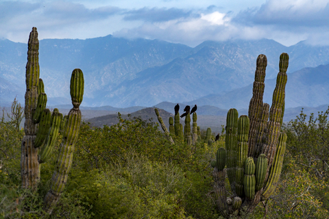
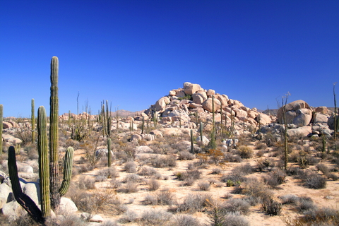
This central desert region is pretty barren. However, it is mostly covered with plants that have adapted and evolved to these conditions, including the giant cactus, the boojum tree, and the elephant tree.
South of La Paz experiences late summer tropical rain averaging 5 inches (130 mm) on the coast and 25 inches (635 mm) in the higher mountains annually.
January through May, as well as November and December, are the best times to visit Baja California as the average temperatures are pleasant, ranging between 68℉ (20℃) and 77℉ (25℃).
The coldest month in Baja California is December, with maximum temperatures reaching 68℉ (20℃). Source: Britannica.com
Baja California's Wildlife
As one could imagine, Baja California supports many tropical plants, from flowers and trees to edible produce, medicinal plants, and cacti.
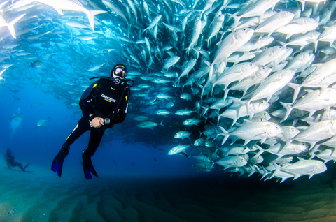
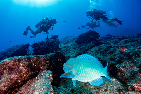
The Gulf of California and Baja California's shores are home to one-third of Earth's marine mammal species.
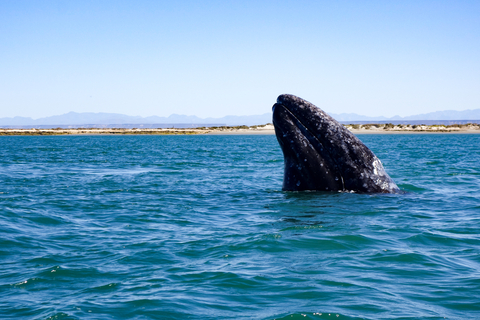
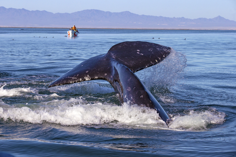
The area is home to many incredible animals, including seals, sea lions, gray whales, shark whales, sharks, schools of fish, and dolphins.
Migratory whales begin arriving in December and hang around until April. The best time to spot gray whales is during the winter, from January to March, along the Pacific Coast.
Pelicans, hummingbirds, and the crested caracara take to the skies. Pronghorn and gray foxes roam the land. With the exceptional weather and food sources, it should be no surprise that the land is full of life, even in the desert region.
Best Parks in Baja California
Loreto Bay National Park
The red area in the Gulf of California, next to Loreto, is Loreto Bay National Park.
Loreto Bay National Park or Parque Nacional Bahia de Loreto protects the Sea of Cortez rich biodiversity. Nicknamed “The Aquarium of the World. It's an excellent location for scuba diving and snorkeling.
The park was established in 1996, and in 2005 Loreto Bay National Park was designated a World Heritage Site by UNESCO. The park is also a Ramsar Site, as its waters and wetlands support waterbirds, fish, and vulnerable ecological communities.
Visitors come to sail out to the islands and relax on beautiful secluded beaches. A look underwater gives you a glimpse of tropical marine life while divers explore the caves and rocky reefs.
Species in the park include lizards, snakes, jackrabbits, seagulls, and booby birds. Aquatic organisms include sea lions, sea turtles, humpbacks, gray, and blue whales. The incredible aquatic biodiversity is boosted by the migration of whales and fish.
The park hosts a variety of guided tours, teaching visitors about the park while allowing them to go paddleboarding, kayaking, whale watching, sport fishing, snorkeling, and hiking.
Expedia offers different locations for visitors to stay nearby. For more information and a fantastic hotel, check Villas del Palmar.
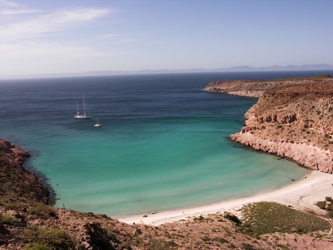
Cabo Pulmo
The red speck east to the tip of Baja California is Cabo Pulmo National Marine Park. Cabo Pulmo Park is just 60 miles north of Baja California's tourist epicenter, Los Cabos.
The park is surrounded by an undeveloped desert with an incredible mountain range. The beautiful beaches give way to the shallow bay cradling one of three living reefs in North America and the only hard coral reef.
It is estimated that over 800 species of marine organisms live within the park. Five endangered turtle species call the area home. The park has an incredible variety of sharks, including bull sharks, hammerheads, tiger sharks, whitetip, and blacktip sharks.
The park encourages visitors to have an eco-friendly and sustainable visit!
Visitors can explore the magical underwater environment and go sea kayaking, paddle boarding, and hiking.
The many cultural experiences in the town of Cabo Pulmo include music, museums, dining, and more; Cabo Pulmo.
For locations and stays in Cabo San Lucas, visit this link from Hotels.com.
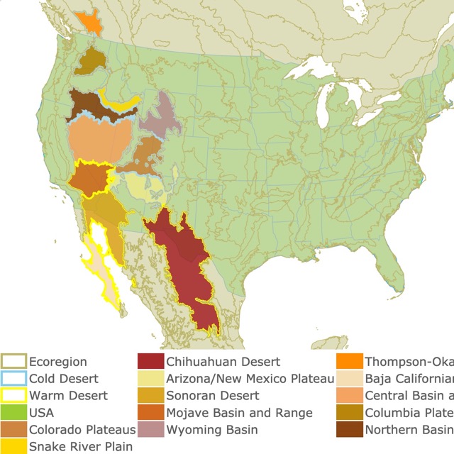
In case you want to learn about deserts in the U.S., check this map!
Constitucion de 1857
The red speck southeast of Tijuana is Parque Nacional Constitucion de 1857.
Constitucion de 1857 is not like any other habitat or park in Baja.
The beautiful conifers, wildflowers dotting the fields, and the lake, Laguna Hanson, are stunning and unique in the area.
The park is a refuge for terrestrial species and holds the only freshwater body in Baja California. These lakes might be the only ones in the peninsula, but they may also dry depending on the rains.
Some species found in the park include pumas, deer, sheep, coyotes, and cougar.
The area is ideal for hiking, camping, mountain biking, nature trips, wildlife observation, canoeing, and fishing (if the lake is not dry); Constitucion 1857.
Sierra de San Pedro Martir
The small red polygon east of San Felipe is Sierra de San Pedro Martir National Park.
San Pedro Martir has relatively cool summer temperatures, unlike most of the hot and arid Baja California landscape.
San Pedro Martir has the peninsula's tallest peak, Pichaco del Diablo, at 10,000 feet (3,048). This park's high elevation landscape includes cypress trees, pines, and towering snow-capped mountains (during the winter).
Mule deer, cougar, bighorn sheep, bobcats, and coyotes call the area home. Visitors are given the rare opportunity to observe California's condors in their natural habitat, thanks to the successful reintroduction program that released these endangered birds in 2002.
One of the park's most exciting features is the National Astronomical Observatory, home to the second-largest telescope in Mexico. If you visit the park, add the Observatory to your must-see list.
The park has beautiful vistas and rugged trails thanks to its varied topography. Visitors are welcome to camp or stay the night at cabins; San Pedro.
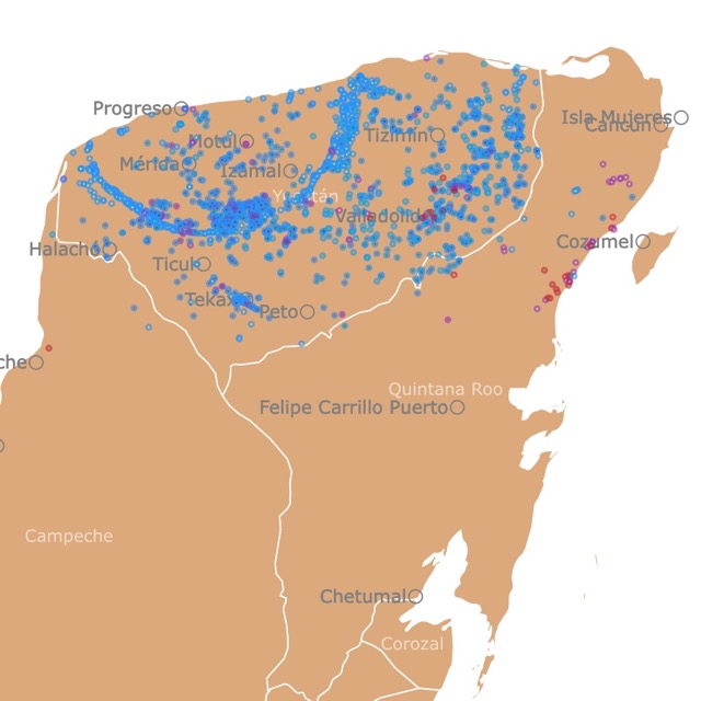
Map of Cenotes in Yucatan, Mexico
El Vizcaino
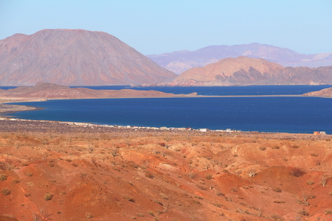
The large green area in the center of Baja California is El Vizcaino Biosphere Reserve.
This is one of Mexico's largest protected areas. It comprises three zones, the mountains, the flat areas, and the coastal zone with over (297mi) 450Km of beaches.
The park is a part of a great biological corridor. It includes lagoons, islands, plains, marshes, dunes, canyons, desert flora, and archeological sites.
Birds, whales, sea lions, seals, dolphins, and elephant seals make the park an excellent area for wildlife observation.
The area serves as a vital whale sanctuary, so you're bound to spot a few whales during your trip. This is a major sanctuary for gray whales.
Snorkeling allows visitors to experience underwater marine life; El Vizcaino.
Sierra de la Laguna
Sierra de la Laguna Biosphere Reserve is the green area on the map, at the tip of Baja California.
This is a semi-arid area with temperatures close to 95°F (35°C) most of the year. The mountains experience heavy rains between July and October.
Visitors come for the gorgeous beaches and incredible coast, but discover a rugged topography perfect for adventure! The Granite mountains range from dry tropical forests to sandy shores, with steep valleys, canyons, and plains.
The park holds Picacho de la Laguna, the highest peak in the state of Baja California Sur, with 7,090ft (2,161m).
The varied landscape and topography, result in plant and animal diversity. There are over 220 plant species, including palm trees, cacti, and pine trees. There are also mountain lions, scorpions, kangaroo rats, desert mule deer, badgers, and gophers.
The park offers outdoor recreational opportunities like hiking, bouldering, canyoneering, scrambling, and summit bagging. The miles of undeveloped land contain hidden trails throughout the mountains.
Sierra de la Laguna Biosphere Reserve is the green area on the map, at the tip of Baja California. Sierra de la Laguna.
For more locations and details on Baja California's experiences, check this book found on Amazon. Moon Baja: Tijuana to Los Cabos is a travel guide with culinary delights, itineraries, activities, and road trips to the best sites in Baja.
World Map of Deserts
Zona Marina del Archipielago del Espiritu Santo
Zona Marina del Archipielago del Espiritu Santo are the islands in red, just north of La Paz.
The area is part of The Gulf of California, UNESCO's World Heritage Site.
The archipelago's isolation, scenic beauty, volcanic origin, and wildlife turn the park into a magical place.
The contrast between the desert and the sea is incredibly captivating. The park's numerous beaches are tranquil, while the pristine surroundings make it one of the main attractions.
The terrestrial part of the islands has over 200 plant species (53 endemic) and about 70 animal species. The aquatic side has over 50 marine bird species and at least 15 sea mammals. These include a colony of sea lions with over 300 animals.
The marine habitats include mangrove forests, coral reefs, coastal lagoons, and bays.
Visitors can hike or walk the various trails or scuba dive in its waters . Choose from over 20 beaches for recreation and camping. Visitors can explore the park aboard a boat, yacht, sailboat, panga, or sea kayak; Archipielago Espiritu Santo.
Valle de Los Cirios
Valle de los Cirios, is the large fuchsia area over central Baja California.
This is a natural protected area in the Cataviña or Central Desert of Baja California. It is one of the largest protected areas in Mexico.
It has shores on the Pacific Ocean and the Gulf of California. The Pacific Ocean side is cool and windy, while the Gulf side is warm and calm. On its shores, you may find cliffs and beaches.
The Valle de Los Cirios has varied physiography, where massive granite rocks are abundant.
The park has a high plant species richness. It is a biological corridor between Sierra de San Pedro Martir and the Vizcaino Desert.
The valley's name is attributed to the "Cirios" plant or Boojum tree, a desert plant that looks like a candle and can reach 49ft (15m).
The park is also a habitat for giant Cardons, the Torote, and various cacti species. The area is also known for bighorn sheep, bats, deer, coyotes, puma, and lynx.
Because of the low population density there are very few trails.
If you visit this park, check out the cave paintings of Catavina. Tour guides can be hired to help you explore the desert in-depth, and they'll share interesting info along the way; Valle de los Cirios.
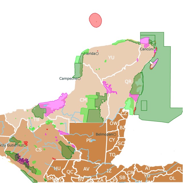
Map of Parks in the Yucatan Peninsula, Mexico
Zona Marina Bahia de Los Angeles
The Zona Marina Bahia de Los Angeles is the green area east of Punta Prieta. It surrounds the island Isla Angel de la Guarda. Next to the town of Bahia de Los Angeles and known as "Canal de las Ballenas" Channel of the Whales.
Bahia de Los Angeles, or Bay of Angels, is a region that holds the most productive oceanographic system throughout the Gulf of California. The cold, nutrient-rich waters are home to a large population of dolphins, whales, seabirds, fish, and 5 species of sea turtles.
September is the best time to visit if you want to see whale sharks. December and January are the months when most foreign visitors arrive. August can reach temperatures of 97°F (36°C).
The accommodations in Bahia de Los Angeles range from hotels to campgrounds along the beaches.
There are at least three campgrounds visitors can choose from. Each one has something different to offer, with everything from a sports fishing hub to backcountry beach sites without any facilities.
Hiking, swimming, picnics, camping, fishing, water sports, and beachgoing are popular activities.
Whale-watching opportunities are abundant! Channel of the Whales.
You cannot reach this isolated destination without taking the appropriate gear. Amazon has the Aozintl snorkel set. It includes goggles with nose cover, fins, snorkel, and bag. The goggles are anti-fog and anti-leak.
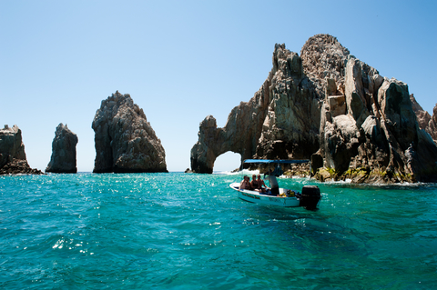
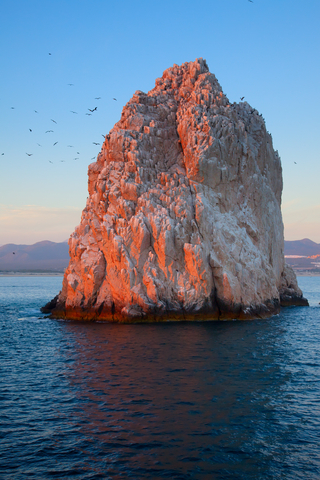
Cabo San Lucas
Cabo San Lucas is the southernmost fuchsia speck in Baja California del Sur.
Tourists flock to Cabo to visit its white sand beaches, desert landscapes, fertile waters, and incredible stone cliffs.
Iconic locations include the Arch at Land's End. This natural rock formation marks where the Pacific Ocean meets the Sea of Cortez. This is the emblem of Cabos.
Another well-known site is "Playa del Amor", or Lover's Beach. Here visitors can sunbathe and swim on a quiet beach. Not far is Divorce beach, with strong waves which are quite dangerous.
Some years, due to changing conditions, it is possible to walk from Lover's Beach to the Arch. Nevertheless, tides may rise suddenly and leave visitors stranded or swept by the waves. Therefore, it is forbidden to walk around the Arch!
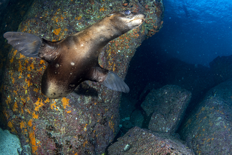
Visitors also enjoy the colonies of seals and sea lions that are accustomed to visitors roaming around.
The park is popular because of its reputation, but more so for the quality of outdoor recreation, fishing, sailing, and opportunities for fun in the sun.
The construction of the international airport in the 1980s made traveling to Cabo San Lucas easy for people from around the world to visit. The region was a go-to vacation spot for Hollywood stars, leading to the world-class resorts growing in number.
Cabo San Lucas is known for its sheer decadence. The area contains sprawling golf courses and deluxe villas.
Unfortunately, some of these resorts are depleting the aquifers and disrupting the natural "Corridor" between San Jose del Cabo and Cabo San Lucas; Cabo.
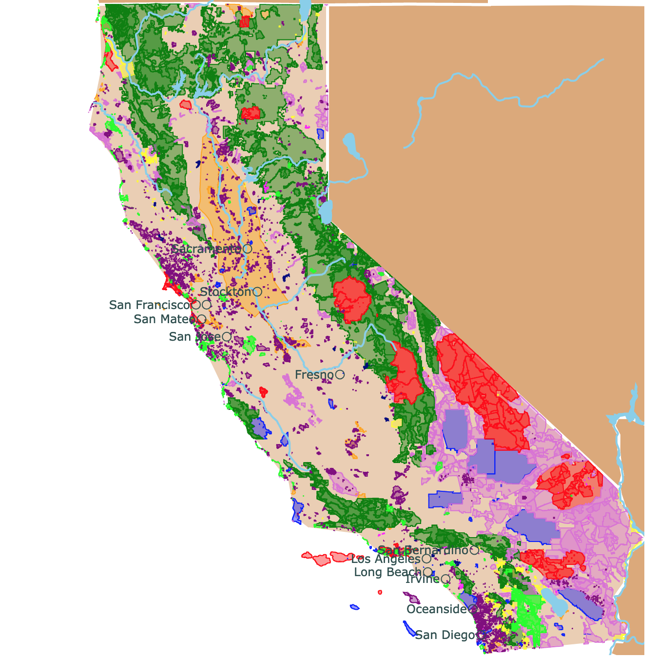
Map of National Parks, State Parks, and National Forests of California
Gulf of California Islands
The Gulf of California Islands are colored in fuchsia and are scattered throughout the Gulf of California.
The islands comprise close to 250 coastal areas and islets. The Sea of Cortez and its various islands are known as a natural lab for investigating species of flora and fauna.
Almost all of the significant oceanographic processes in the oceans are present in the area, causing it to be of extraordinary importance for studying.
The Gulf of California Islands site provides a picturesque natural setting where beauty is abundant. Imagine rugged islands with high cliffs and sandy beaches that contrast with the arid desert and the surrounding cyan-colored waters; UNESCO.
Complejo Lagunar Ojo de Liebre
The small green area between el Vizcaino and Valle de Los Cirios, next to Guerrero Negro.
The Complejo Lagunar Ojo de Liebre is a biosphere protected by the Mexican government. The 404,500 (163,765 hectares) site supports 32 percent of the biographic population of birds like the Marbled Godwit, 32 percent of Red Knot, and 68 percent of short-billed dowitcher.
Furthermore, this site is vital as it is where new calves of gray whales are born each year..
Visitors must remain mindful and aware of the region's delicate nature and importance. It's a nature lover's living museum; Ojo de Liebre.
World Map of Deer Geographic Range
Isla Guadalupe
The green polygon west of Baja California, is the Biosphere Reserve Isla Guadalupe.
This remote and isolated location makes this island an exceptional place. The flora and fauna are quite unique.
The topography is awe-inspiring, as upon arrival the North Head is a solid rock rising 4,200 feet (1,280m) above sea level. This large projection over the sea can affect the local weather!
It is common to see a sizeable thick fog surrounding the island during the day and spilling over the island in the afternoon.
The islands are home to colonies of Northern Elephant Seals and Guadalupe Fur Seals. Another well-known inhabitant is the Great White Shark. They come in warm weather, along with yellowfin tuna; Guadalupe.
The main activities on Isla Guadalupe are hiking and fishing. Much of the area's coastline consists of high cliffs, which makes beach and shoreline activities almost impossible.
All of the beaches are only a mile or less in length.
A boat tour is the most efficient way to view the island, but the best experience is on the island itself.
Zona Marina del Archipielago de San Lorenzo
The small red rectangle west of Hermosillo in the Gulf of California is the Zona Marina del Archipielago de San Lorenzo.
San Lorenzo Archipelago National Park comprises the islands of the Archipelago of San Lorenzo, Salsipuedes, Las Animas, Rasa, and Partida. The islands of San Lorenzo are surrounded by deep cold waters of the Sea of Cortez.
A more significant portion of the park comprises a maritime zone. The small land area contains rugged islands with jagged and eroded coastlines with numerous sea cliffs.
The park is an important ecological area in the Gulf of Califronia. It's an excellent location for whale and bird-watching opportunities.
FOLLOW ME
Resources for California's Protected Areas Map
The shapefiles with Mexico's Northwestern Region state boundary lines, major rivers, lakes, and cities were downloaded from Natural Earth Data.
The shapefiles with Mexico's National Parks and State Parks were downloaded from CONABIO.
This map will be updated with new data! To receive updates on this and more nature maps, join my email list!!!!!!!
Made by Luz K. Molina with D3.js.