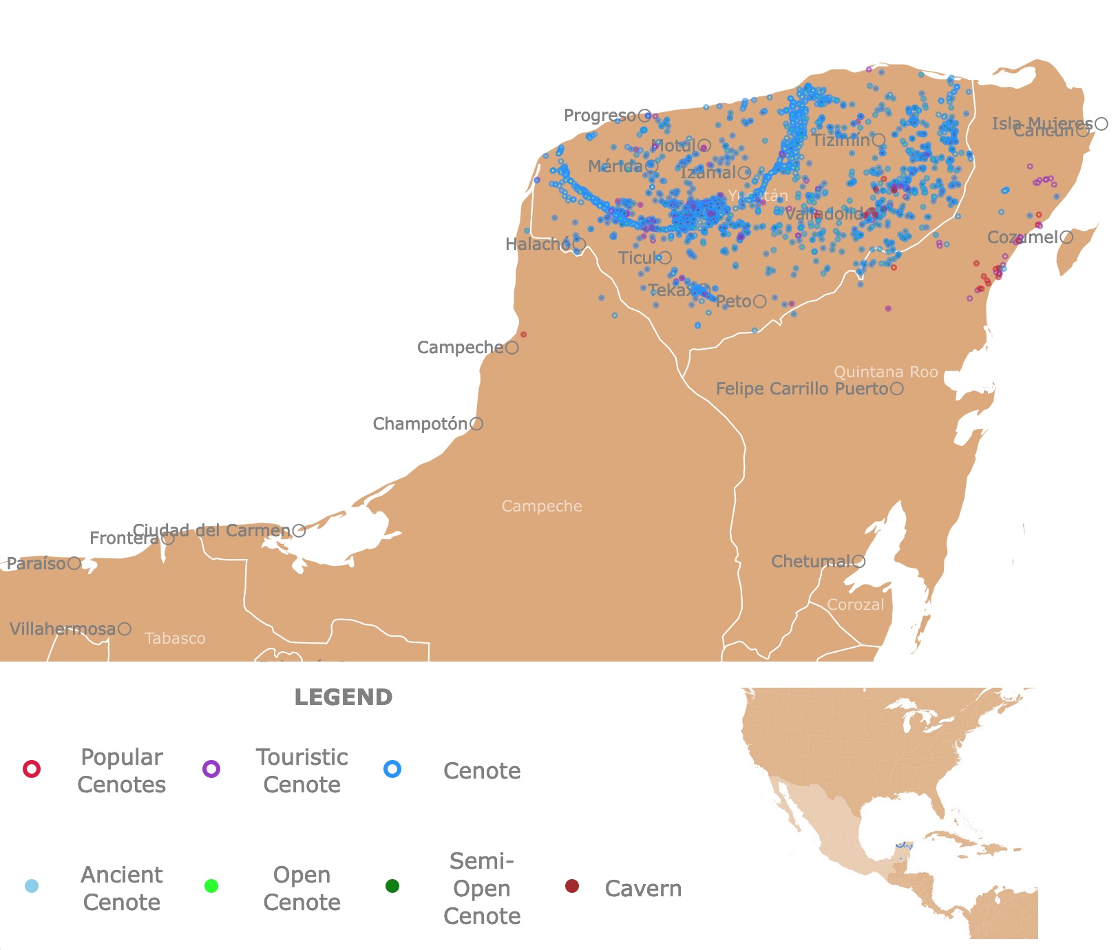
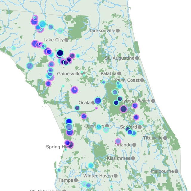
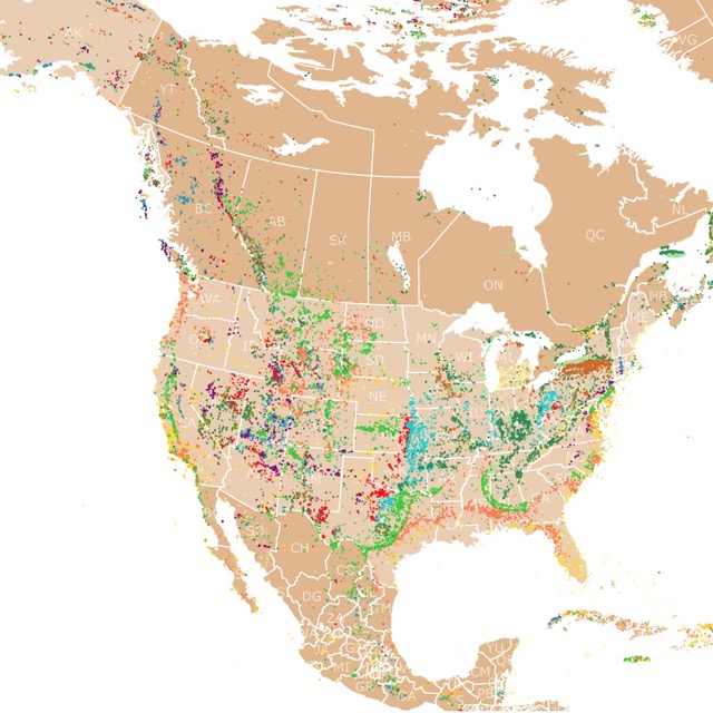
Map of Cancun Cenotes
This interactive map shows the location of cenotes in the Yucatan peninsula surrounding Cancun. The color indicates if they are open for visitors. Hover over the map for names and specifications on each cenote. For more detail, zoom on the map. For more information, scroll down.
| LEGEND | 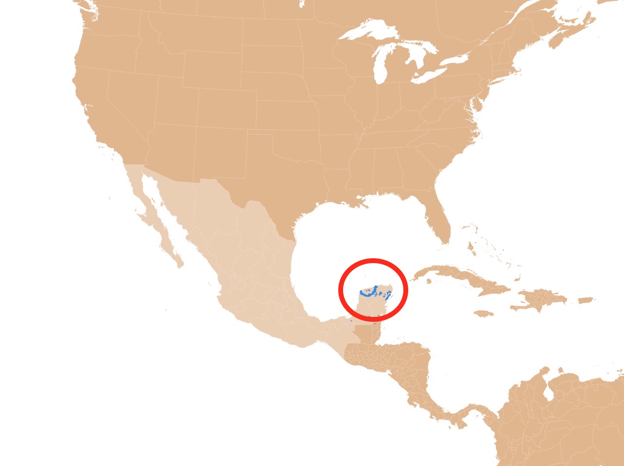 | ||||||||
|---|---|---|---|---|---|---|---|---|---|
| Touristic Cenote | Cenote | Ancient Cenote | |||||||
| Open Cenote | Semi-Open Cenote | Cavern | |||||||
What is a Cenote?
A cenote is a sinkhole formed by the dissolution of rock resulting from the collapse of limestone. They are filled with rainwater filtered through rock.
The rock that falls after collapsing is slowly removed by dissolution.
Because saline water may also intrude from the coast, cenotes have fresh and saline water. Due to density differences, saline water is beneath freshwater.
The water temperature of cenotes remains constant with an average water temperature of 77°F (24 to 25°C). The maximum temperature of a cenote is 75°F (23°C).
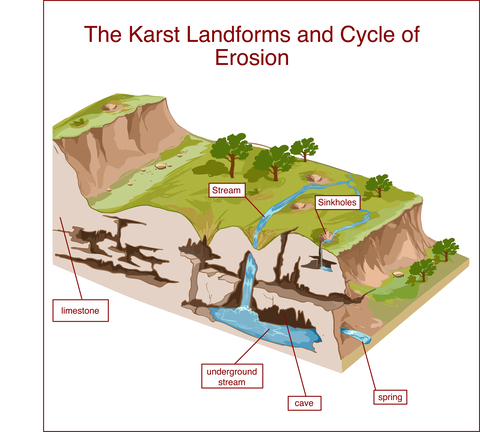
The topography that results from the dissolution of soluble rocks like limestone and forms underground drainage, caves, and sinkholes is known as Karst.
Some cenotes are found through small holes created by roots. Human access, such as ladders, is later made for visitors to access cenotes.
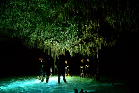
Many cenotes are open for tourists to swim in and walk. Others are open to cave exploration and even diving. Cave divers must be aware that some caves have not been thoroughly explored. They require special equipment and certification.
For more fun places to visit, check this map of Parks in Yucatan, Mexico
Where are Cenotes Found?
The term cenote is associated with the Yucatan Peninsula, where they are widespread. Still, they may also occur in low latitude islands and coastlines.
The Yucatan Peninsula is located in southern Mexico. The peninsula is flat and has a low altitude.
Yucatan has extensive limestone formations thanks to its coral reef past.
It is estimated that there are over 6,000 cenotes in Mexico. This map only displays 2091 cenotes.
Thanks to the cenotes below the ground, Yucatan has a vast aquifer with two of the world's largest underground water systems.
The largest aquifer is called Sac Actun and is about 219mi (353Km), the second-largest is Ox Bel Ha, and it is 167mi (270Km), source Divecenotes.
Due to its geological history Cancun is surrounded by cenotes and blessed with the most beautiful beaches.
If you are planning to visit Cancun Cenotes, visit Expedia for flight deals and specials. Houston has several trips to Cancun throughout the week. For more details click here!
Origin of Cenotes
The Yucatan Peninsula used to be a coral reef about 65 million years ago. The reef grew over time, creating a mile-thick limestone.
Unexpectedly a giant meteorite with a diameter close to 118 miles hit near what is known today as the Gulf of Mexico.
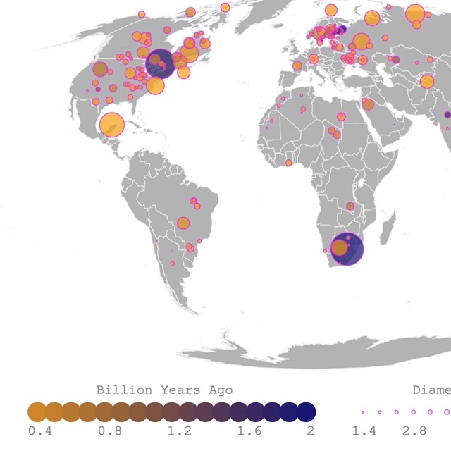
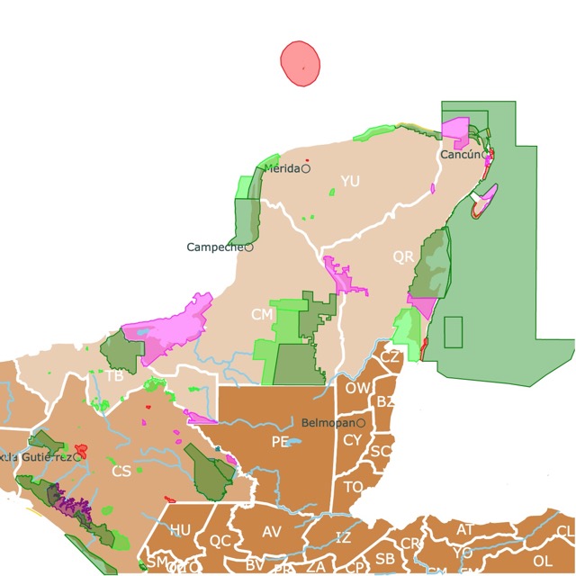
For more information on impact craters and Chicxulub, visit this map!
Chicxulub Crater
The impact of this meteorite was so strong that it triggered earthquakes, tsunamis, and volcanic eruptions around the world.
The amount of debris was so large it came back, igniting the atmosphere and starting global firestorms. The clouds of dust were so vast that they blocked photosynthesis for years.
The impact crater was so big it encompassed part of what is today the Yucatan Peninsula. The site is now known as Chicxulub Crater.
Its effects were so severe that it wiped out the dinosaurs and most life on Earth.
It is theorized that the impact crater crystalized the rock in the area. The outer rim changed where and how water could flow. Therefore, the water flows away from the rim.
Around the crystal rock, the soft limestone dissolved with water and created deep voids. Eventually, these caves collapsed, forming a ring of cenotes, source: Northwestern.
If you look carefully, you will notice a ring of cenotes on the map. It is about 180Km in diameter.
For more information on meteorites, visit this map on Meteorite landings and types
Cave Formation
Different ice ages made the sea level change several times. When the sea level was low, the Yucatan Peninsula was exposed to acidity in the rain. This acidity dissolved the alkaline limestone, creating caves, stalactites, and stalagmites.
When these caves were still dry, about 18,000 years ago, different organisms lived inside them, leaving traces of their existence and fossilized remains.
Some ancient organisms found include camelids, mammoths, giant jaguars, sloths, and horses.
Eventually, rainwater filled the caves. Because most of the water is filtered through the limestone, it is crystal clear, having visibility of more than 100m. Source: the Deepdive.
Cenotes and the Maya
Cenotes have affected human settlements in the peninsula for the last 13,000 years. Cenotes were a source of fresh water in the jungle for the Mayan civilization.
They were so important they were considered sacred. The cenotes were so unique that they thought of them as the entrance to their underworld. This is where they thought their gods and spirits resided after death.
The word cenote comes from the Mayan word "D'zonot", which refers to an underground chamber with permanent water.
Florida also has porous limestone and karst landscapes that resulted in natural springs. For more information, click on this map
Types of Cenotes
Cenotes are classified by their age as Cavern, Semi-open, Open, and Ancient Cenotes, source: Xenotes.
This classification is reflected in some of the cenotes displayed on the map.
- Cavern Cenotes: Also called Grutas. These are the youngest cenotes. They are young because the cavern ceiling has not collapsed.
- Semi-Open Cenotes: Also called jug, pit, or Cenotes Cantaro. These are middle-aged cenotes. Part of them has been exposed to the elements, or the opening is narrower than the water body diameter. Semi-open cenotes may be connected to others, and visitors can easily admire the flora and fauna in the water.
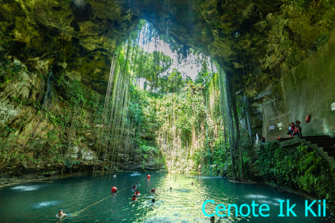
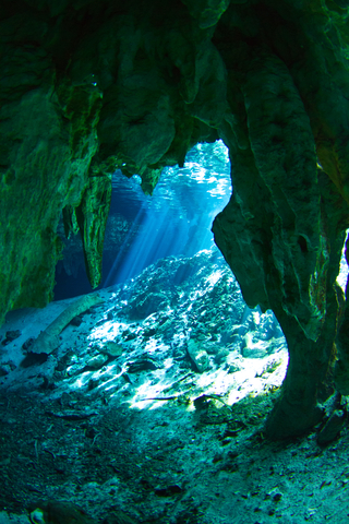
- Open Cenotes: Also called Cilinder or Cenotes Cilindricos. These are some of the oldest cenotes. With time, the roof that covers them collapses, leaving them open. This type of cenote is known for its beauty. They have plants, flowers, and even butterflies.
- Ancient Cenotes: After years of existance the roof has totally collapsed leaving this type of cenote completely open. There are no rock formations in the upper area. They look like a lagoon or spring.
Cancun Cenotes
The most popular Cancun cenotes, are depicted in red on the map. The advantage of these known cenotes is the facilities and ease of access.
Before you visit any cenote, remember they are sacred for the Maya. They are also pristine areas, and to keep them this way, make sure you don't litter. Always take the trash back with you and use organic sunblock!
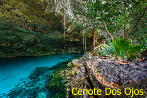
Cenote Dos Ojos
Cenote Dos Ojos or Two Eyes is near Tulum in Quntana Roo. These are two neighboring cenotes connected by caverns that also connects them to an underground aquifer.
The whole system is 310.95 kilometers (193.22 mi).
Dos ojos is open for snorkeling and cavediving, Agua Clara.
Expedia offers package deals to Tulum. Some of these packages are all included. For more detailed descriptions visit this link!
Evidence of Dinosaurs vanished by Chicxulub, plus fossils of other ancient creatures are still found worldwide. To learn more, visit this Map of Fossils in North America
Gran Cenote
Gran Cenote or Grand Cenote is located near Coba and Tulum, in Quntana Roo.
This cenote has a cave with stalactites and stalagmites. It is also possible to snorkel and dive in this cenote.
In Gran Cenote is possible to see bats and turtles. There are also shallow areas for visitors who do not swim! Every Steph
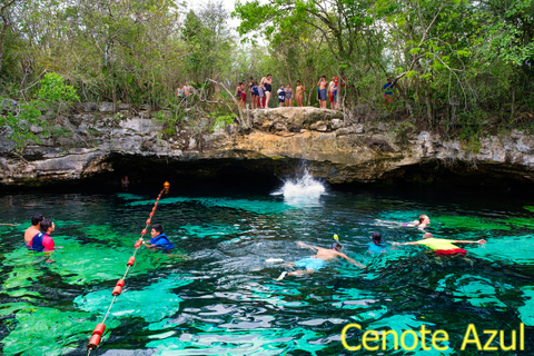
Cenote Azul
Cenote Azul or Blue Cenote is situated near Playa del Carmen in Quintana Roo.
This is an ancient cenote, so it looks like a lagoon. There are different areas of different depths, so visitors might need a swimming vest.
One of the main features of this cenote is a cliff where visitors dare each other to jump into the blue waters! Playa del Carmen.
Cenote Calavera
Cenote Calavera, or the Temple of Doom, is located near Tulum in Quntana Roo. This is a semi-open cenote.
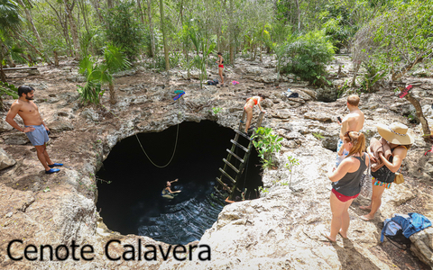
Cenote Calavera is not a very crowded cenote. This cenote has a ladder to access the hole, but visitors prefer to jump in. There is nowhere to stand inside this cenote, so visitors must swim.
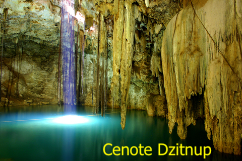
Cenote Samula
This cenote is near the city of Valladolid, in the state of Yucatan. It is close to Cenote Dzitnup and Xkeken.
This is a cave cenote that offers a unique experience as visitors swim in the cave while observing beams of light coming from a small opening on top.
This is a large cenote, and the depth can reach 35m.
Valladolid is close to many cenotes, different Maya ruins, and the Chichen Itza Pyramid. You can make reservations with Hotels.com and have a relaxing stay at Hotel Posada San Juan. For more details on this beautiful hotel visit this link!
Grutas de Loltun
These caverns are in Yucatan, south of Merida. They are the largest caves in the peninsula and the most studied.
Inside these caverns, remains of mammoth, bison, feline, and deer have been found, as well as paintings on the walls.
A special feature of these caverns is that their columns can be played like musical instruments!
A tour takes approximately 2 hours and is 0.6mi (1Km) long.
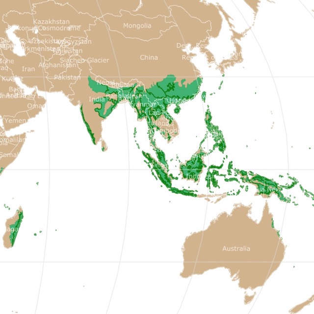
Some of these incredible cenotes are surrounded by Tropical Forests. For details, check this map of Tropical Forests
Cenote Map Sources
The shapefiles with state boundaries were downloaded from Natural Earth Data.
The locations of the cenotes were downloaded from two sources. The first one was Geocomunes (http://132.248.14.102/). The second source was from Yucatan.gob. The second source had more data points and more information on each. Nevertheless, the coordinates were in different formats. I did my the best to clean the data.
FOLLOW ME
Made by Luz K. Molina with D3.js.