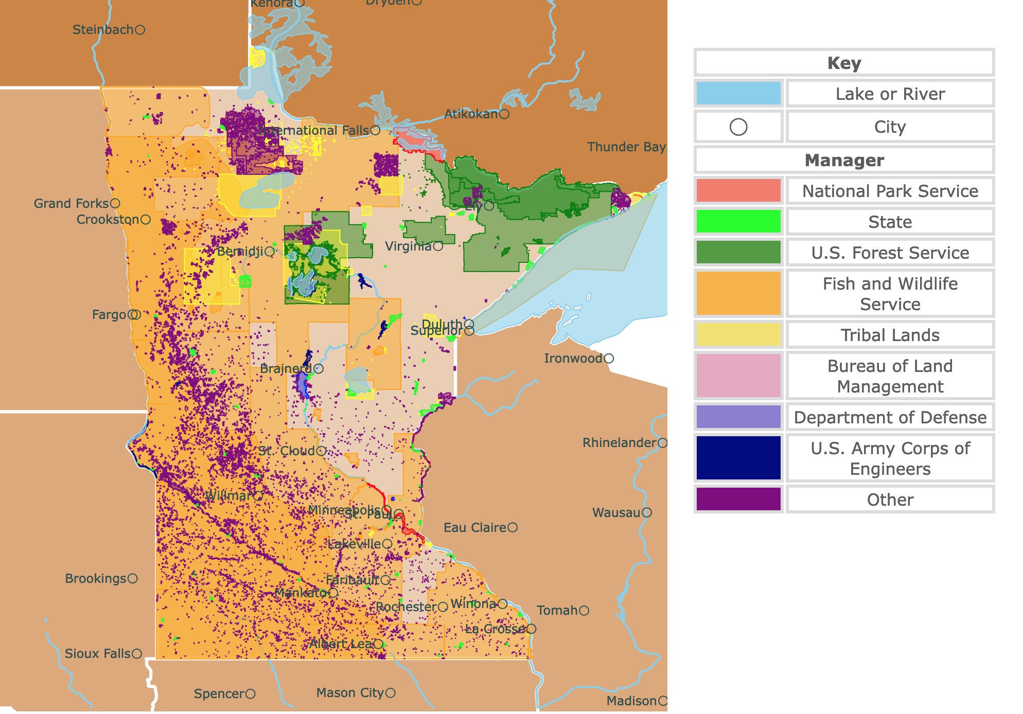
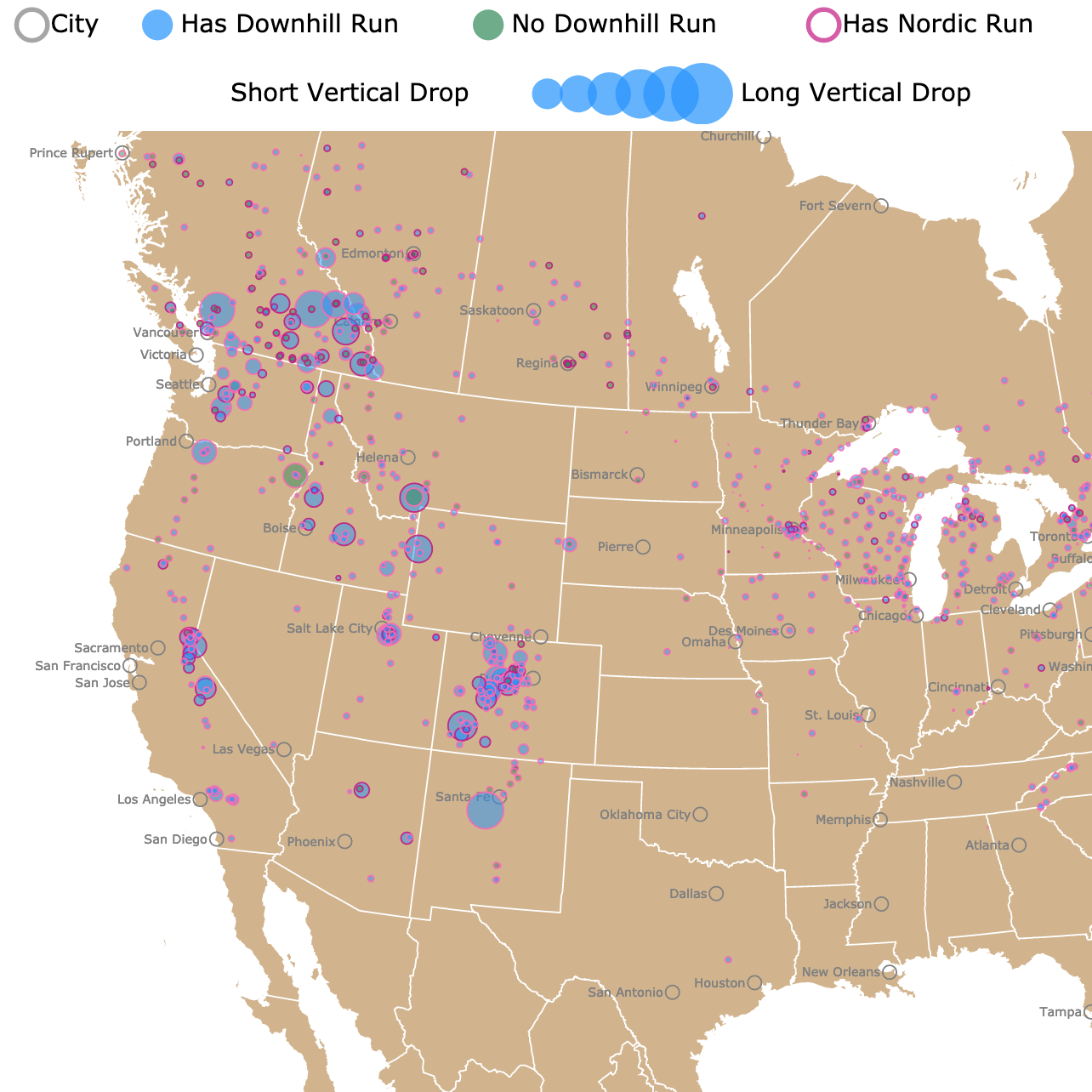
Map of Minnesota's Protected Areas
This interactive map shows the Locations, Names, Areas, and Details of National Parks, State Parks, National Forests, Tribal, and other Public Lands of Minnesota. It also shows major cities and rivers for context. For more detail, zoom in. For more information, hover over the map, or scroll down.
| Key | |
|---|---|
| Lake or River | |
| ◯ | City |
| Manager | |
| National Park Service | |
| State | |
| U.S. Forest Service | |
| Fish and Wildlife Service | |
| Tribal Lands | |
| Bureau of Land Management | |
| Department of Defense | |
| U.S. Army Corps of Engineers | |
| Other | |
Minnesota's Geography
Minnesota is an Upper Midwestern state, part of the Great Lakes Region. The state borders Lake Superior (the largest of the Great Lakes), Wisconsin to the east, the Dakotas to the west, Canada to the north, and Iowa to the south.
Much of the state's topography (the shape of the terrain) was created by glaciers thousands of years ago. The slow-moving masses of ice carved out the plains and low hills of Minnesota and made the lakes that exist today.
Thanks to these glaciers, Minnesota is the land of 10,000 lakes, ok more like 17,246 source: J.A. Downing.
The northern region of Minnesota beholds deep streams and lakes, thick forests, rocky ridges, and Eagle Mountain, the state's highest point.
The Red River Valley (primarily flat area with fertile soil) runs west from the Canadian border to the edge of South Dakota.
The southwestern part of the state is characterized by thick glacial deposits of gravel and clay.
The far southeastern part of Minnesota is unaffected by the glaciers during the last ice age. You'll find stream-cut valleys, high bluffs, and caverns in this part of the state.
Want to find places to explore in nearby North Dakota? Check this map of North Dakota Parks
Minnesota's Climate
The average temperature in Minneapolis - St. Paul during January is 12°F (-11°C). The month of July averages 74°F (23°C).
Winter's are harsh, with below-freezing temperatures, snow, freezing rain, sleet, and ice. Heavy snowfalls occur from November to April, averaging 70 inches (178 cm) a year. A blizzard can be expected at least twice a year on average.
Spring brings transition for Minnesota. Snowstorms are relatively common during the early spring. By late spring, temperatures start warming up. The state's southern portion experiences summer heat and humidity, while the north has less humid conditions.
There is about a 10-degree temperature difference between north and south Minnesota. Autumn is essentially the reverse of spring weather, with lots of rain and wind.
Minnesota Wildlife
Gyrfalcons, snipes, and great horned owls are only a few birds that soar through Minnesota's skies. Some woodland mammals are bobcats, martens, muskrats, raccoons, and white-tailed deer.
With such cool temperatures in the state, it's surprising to find amphibians like the western chorus frog, northern map turtles, and the eastern red-backed salamanders.
Minnesota is home to reptiles such as garter snakes, prairie skinks, and the venomous timber rattlesnake.
Minnesota's 52 native tree species include the American elm, quaking aspen, red pine, white spruce, and mountain maples. Black-eyed Susans, Doll's eyes, sunflowers, sweet pea, and meadowsweet are a handful of the state's wildflowers.
The best time to visit Minnesota is between June and August. Summer marks the peak tourism season, and you can find farmer's markets and festivals in large numbers.
Autumn ranks as another excellent time to visit, with the beautiful fall colors and cool temperatures.
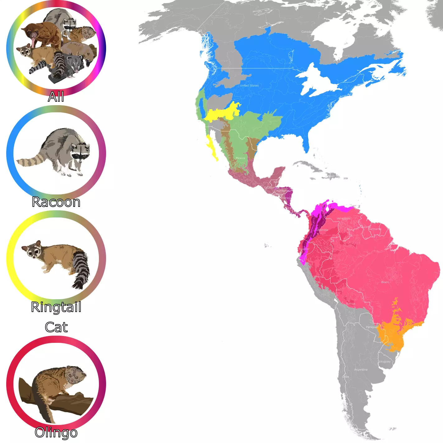
If you want to learn more about the raccoons living in Minnesota, check this map!
Best Parks in Minnesota
Voyageurs National Park
Voyageurs National Park is located in northern Minnesota, next to the border of Canada. It is on the shores of Rainy Lake and is represented in red.
Voyageurs is an adventure wonderland with over 218-thousand acres to explore all year long.
The park has exposed rock ridges, wetlands, forests, cliffs, lakes, and streams. All these features turn this park into a progression between aquatic and land ecosystems, between northern hardwood and southern boreal forests, as well as between natural and developed areas.
All Backcountry and Frontcountry camping require a watercraft to access the site and need a permit.
If visitors don't have a boat and prefer to drive to a campsite, they can find private and public campgrounds within the surrounding gateway communities.
Visitors can also rent canoes from the mainland and explore places like Namakan, Rainy, Sand Point, Kabetogama, or Crane Lakes. Local businesses in the area offer rentals.
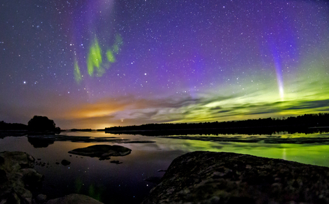
An additional asset of this park is that it is possible to see the Northern Lights if you come in the right conditions, mainly clear skies!
Unlike many parks that rely on rangers and forest crews to maintain the area, Voyageurs has volunteers. They help maintain the facilities, keep the visitors center open, and rehabilitate historic sites.
Outdoor enthusiasts have much to do at this national park, including boating, fishing, camping, hiking, house boating, tours, events, programs, and even winter activities, Voyageurs.
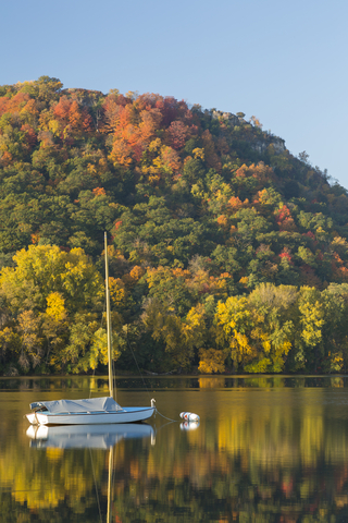
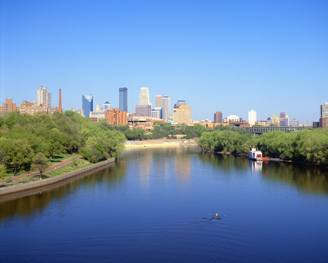
Mississippi National River and Recreation Area
The Mississippi National River and Recreation Area is the red stripe in southeastern Minnesota, along the Mississippi River and Minneapolis.
This area is a partnership park. Therefore, the land within the borders is mainly owned by others like city, county, and state governments. There are no admission fees; however, some locations require admission and parking fees within the park, charged by the park's partners.
A network of roads that run parallel and cross the river from the parks lining the river's bank provides access.
The Mississippi Recreation Area, visitor's center, can be found in the Science Museum of Minnesota's lobby and is an excellent place to begin your journey.
Even though this is basically an urban park, it offers ice fishing, snowshoeing, cross country skiing, biking, hiking, and camping.
Cold Water Springs offers a beautiful place to hike. The trails in the area surround a restored prairie oak savannah and wetlands. It's a significant cultural and historical gem that shouldn't be missed, source Mississippi Rec.
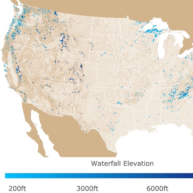
Minnesota has lots of waterfalls, but if you want to see more, visit this map of U.S. waterfalls
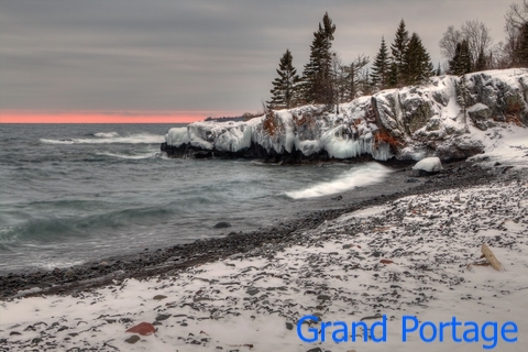
Grand Portage State Park
Grand Portage is the tiny lime green speck on the most northeastern corner of the state. You probably have to zoom in to find it.
The park is on the U.S. - Canadian border, in Silver Bay, Minnesota; High Falls on Pigeon River is on the Canadian side in Ontario.
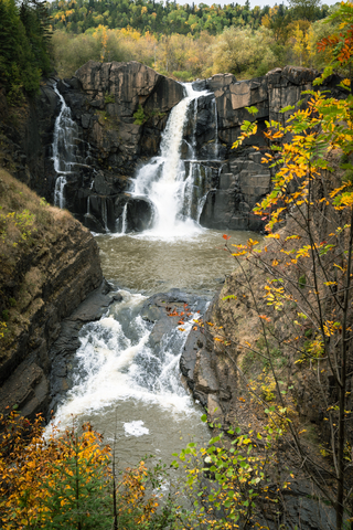
The park is in the Grand Portage Indian Reservation, but if Lake Superior is on your mind, it's only about a mile east of Grand Portage State Park.
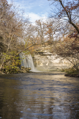
The Cascades of water fall 120 feet (36.57 meters) over High Falls, down into Pigeon River. High Falls is the tallest fall in the state.
The falls were a severe obstacle for river traveling, so a portage or carrying place was required. The Indigenous people created a nine-mile trail from Lake Superior to avoid the falls. Hence the name "The Grand Portage".
Nowadays, tourists with different capabilities can take the half-mile trail and boardwalk to view the falls.
The park is for day use only, so no camping is allowed. Still, the hardwood-conifer forests and hiking trails along the beautiful Pigeon River make for fantastic scenery.
Visitors enjoy recreational activities such as hiking and backpacking. The scenery is perfect for a picnic and photography, Grand Portage.
Banning State Park
Banning State Park is situated on the eastern side of Minnesota, south of the city of Duluth.
Spring is a popular season for adventurous canoeists and kayakers who love floating down the Kettle River, as it is filled with rapids and excitement.
Visitors appreciate the hike along the Kettle River with the breathtaking sandstone rock formations, abundant mosses, fluorishing lichens, and liverworts. Meanwhile, Wolf Creek allows viewers to see the old ruins of Banning Sandstone Quarry.
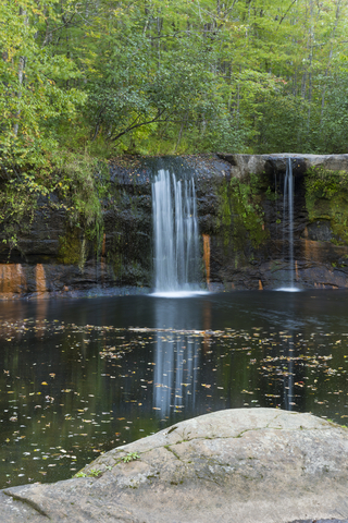
The park has wetland vegetation, mixed hardwood, pines, and aspen-birch. It also has waterfalls on Wolf Creek.
Camping, cross-country skiing, picnicking, the opportunity for photography, and wildlife watching are a few of the park goers' favorites. Not to mention the beautiful hiking trails and a chance to study natural history.
Banning State Park is a popular place for birdwatchers and nature lovers. There have been over 180 species of birds sighted at the park, in addition to 34 species of mammals.
Animals seen at the park include black bear, coyote, fox, red and gray squirrels, white-tailed deer, snowshoe hare, ruffed grouse, and beaver. There are 17 species of reptiles and amphibians for the amphibian lovers, source Banning.
Looking for more places to ski? Go to this map of Ski Resorts in North America
Tettegouche State Park
Tettegouche State Park is situated on the northeastern side of the state, located along Lake Superior.
This state park's cliffs are a sight to behold. The incredible views at Shovel Point and the cascading 60 foot (18.28 meters) High Falls of the Baptism River are two of the many things that attract visitors.
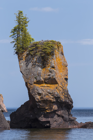
The beautiful landscape is the product of erosion by glaciers and water.
Tettegouche Camp allows visitors to camp, and the miles of trails overlooking the Sawtooth Mountains are a hiker's paradise.
The inland lakes are only accessible by foot, and the view alone is worth the hike.
The Palisade Valley has stunning vistas and multi-use, all-seasons trails. If you're into fishing, there are two more trout lakes within the rest of the park. If you're not a fan of the water, the park offers rock climbing opportunities as well.
The park's wide variety of plant communities supports over 40 species of mammals. The most commonly seen are red squirrels, white-tailed deer, red fox, black bear, and snowshoe hare. Occasionally, visitors glimpse fisher pine martens, coyotes, northern flying squirrel, and timber wolf.
For the bird lovers out there, Minnesota is recognized as one of the top areas throughout the nation to see rare birds. Furthermore, the park helped bring back the peregrine falcon that was once wiped out of the park thanks to DDT, Tettegouche.
Minneopa State Park
Minneopa State Park is located in south-central Minnesota; it is the lime green polygon next to Mankato.
In the Dakota language, Minneopa means "water falling twice". The gorgeous waterfalls of Minneopa Creek inspired the name.
Visitors must walk down the trail around the falls. It leads to a stairway made of limestone, then the valley below. If visitors go up to the opposite side, there is a stunning view of the valley.
The Seppman Mill is a popular site where visitors can see a windmill made of stone and lumber.
If history and culture aren't your things, maybe you will enjoy a hike through the oak savanna and the native prairie grasslands.
Minneopa is home to the different songbird species. Migrating birds also stop at the park on their way to their summer nests. Tree sparrows, red-tailed hawks, and American bald eagles are enough to get bird lovers out for a visit.
Bison herds can be viewed at Minneopa State Park. Visitors can drive through over 300 acres of bison range and learn about bison conservation, source: Minneopa.
Want to find places to explore in nearby Wisconsin? Visit this map of Wisconsin Parks
Blue Mounds State Park
Blue Mounds State Park is located in the southwestern corner of the state, depicted in lime green.
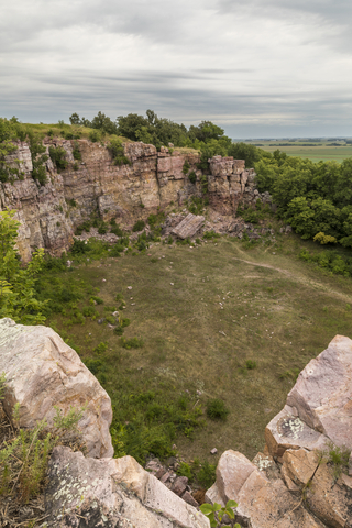
One of the park's main visitor magnets is the Sioux Quartzite Cliff, which is 100 feet (30.48 meters) above the flat surrounding landscape.
Millions of years ago, the cliff was sandstone that transformed into hard quartzite. Posterior glaciations shaped the landscape into what it is today.
If you're patient, you might spot bison grazing in the prairie grass. The prickly pear cactus blooms in June and July, and a sea of prairie flowers bloom in spring.
Visitors can enjoy camping, hiking, rock climbing, wildlife watching, bison viewing, and the beautiful wildlife living and growing all around. Don't forget the camera, because there's something incredible around every corner, source: Blue Mounds.
Affiliate Disclosure
Databayou.com is a participant in the Amazon Services LLC Associates Program, an affiliate advertising program designed to provide a means for sites to earn advertising fees by advertising and linking to Amazon.com. Databayou.com also participates in affiliate programs with Clickbank, CJ, and other sites.
If you plan on visiting one of these parks or walking Minnesota's shoreline, I suggest you get some of these items found on Amazon.
- Waterproof snakeproof boots should be something you consider when hiking in rattlesnake territory.
- Sleeping Bag: Perfect for temperetures below 0 degrees, this large sleeping bag is lined with flannel and waterproof.
- Scope with Tripod: This is ideal for all the wildlife in Minnesota parks. This scope comes with a tripod and a smartphone adapter.

For more lakes around the U.S. visit this map of Lakes and Ponds
Resources for Minnesota's Protected Areas Map
The shapefiles with Minnesota's state boundary lines, major rivers, and cities were downloaded from Natural Earth Data.
The Parks and Public Lands shapefiles for Minnesota were downloaded from USGS.
This map will be updated with new data! To receive updates on this and more nature maps join my email list!!!!!!!
Made by Luz K. Molina with D3.js.