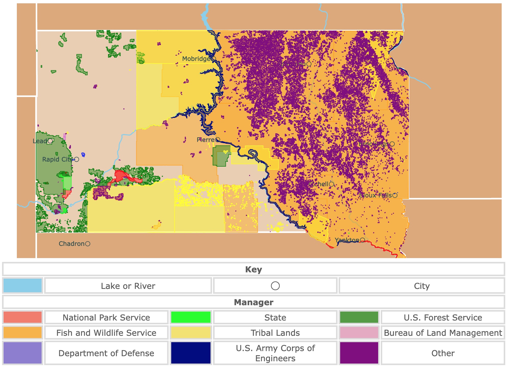
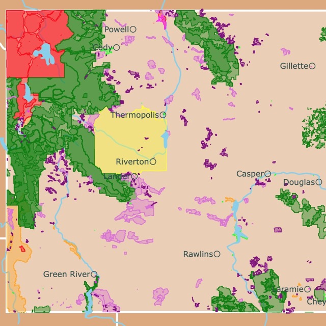
Map of South Dakota's Parks and Protected Areas
This interactive map shows the Locations, Names, Areas, and Details of National Parks, State Parks, National Forests, Tribal, and other Public Lands of South Dakota. It also shows major cities and rivers for context. For more detail, zoom in. For more information, hover over the map, or scroll down.
| Key | |||||
|---|---|---|---|---|---|
| Lake or River | ◯ | City | |||
| Manager | |||||
| National Park Service | State | U.S. Forest Service | |||
| Fish and Wildlife Service | Tribal Lands | Bureau of Land Management | |||
| Department of Defense | U.S. Army Corps of Engineers | Other | |||
South Dakota's Geography
South Dakota is in the upper middle portion of the United States. The neighboring states include North Dakota to the north, Nebraska to the south, Iowa and Minnesota to the east, and Montana and Wyoming to the west.
Glacial lakes, prairies, and fertile farmlands dominate the beautiful landscape in eastern South Dakota. Central South Dakota boasts ranchland and prairies.
The western skyline highlights the mountains and formations like buttes and canyons.
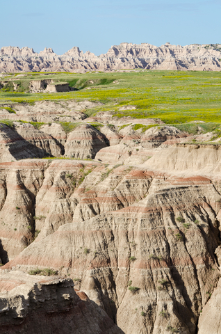
The southwest is characterized by the Badlands. Badlands are dry terrain that has been eroded, creating slopes, buttes, and hoodoos. These formations seemingly rise above the surrounding prairie land.
The Badlands have some of the richest fossil beds in the world. The range of fossils includes saber-toothed cats to marine organisms.
The Missouri River flows through the southeastern and central parts of South Dakota. Thousands of years ago, several lakes formed by glaciers dot the state's northeastern corner.
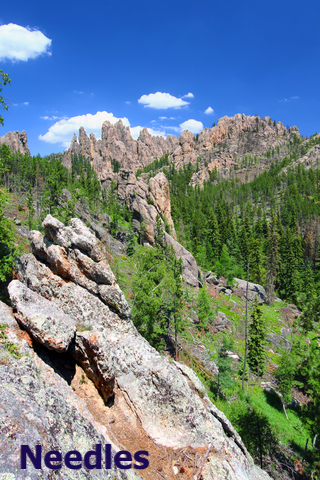
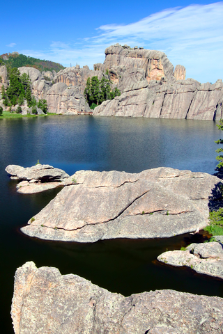
South Dakota is home to several incredible geological formations, including Needles Eye, close to Custer Park. The granite rocks are definitely a sight to behold. The eye was formed by years of wind, rain, and ice, Neeles Eye
Want to find places to explore in nearby North Dakota? Check this map of North Dakota Parks
South Dakota's Climate
The state of South Dakota experiences four distinct seasons. There is mild weather with showers during the spring, while summers are full of sunshine, warmer temperatures, and slight humidity.
Autumn brings crisp cool evenings, and winter temperatures range from mild to extreme.
Like most places, South Dakota's climate varies based on the location. The Missouri River divides the state; the easter half typically experiences more regular precipitation and humidity. The western half is graced with drier conditions.
Late May to early September seems to be the most popular time to visit South Dakota. The state gets around 15 to 16 hours of daylight during these times.
The temperatures will vary depending on the area of the state you're visiting. Average summer highs of 90°F (32°C) can be expected during the day, with the lows around 60°F (16°C) at night.
Winter temperatures range from mild to extreme. The average winter highs in the state are 46°F (7.7°C), while the lows drop down to 18°F (-7°C), Weaterspark.
South Dakota's Wildlife
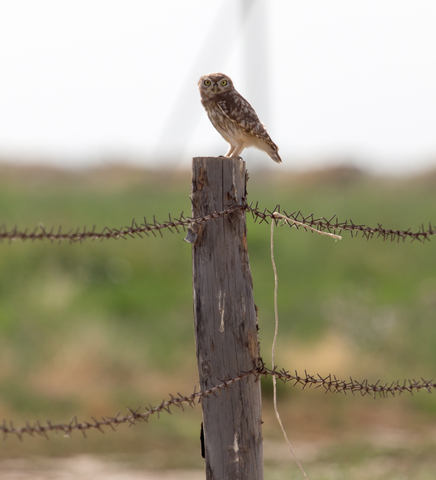
The wide variety of habitats in South Dakota (grasslands, mountains, prairies, rivers, and lakes) support diverse wildlife. Animals like bison, prairie dogs, and pronghorns roam the prairies. In the mountains, mountain goats and mountain lions are common.
The South Dakota skies have a variety of bird species, including the state's bird, the ring-necked pheasant. The rivers and lakes are home to numerous fish, including walleye and paddlefish.
The forests and land are dotted with beautiful trees, including the box elder, sugar maple, nannyberry, quaking aspen, and basswood. High-bush cranberry, elderberry, and chokecherry are a few of the beautiful shrubs common in the state, source: Plantnative.
South Dakota has a deep history and is full of Native American or Indigenous culture. Nine tribes call South Dakota home. It's the land of the Dakota, Lakota, and Nakota people. Each of them has stories about the land and how it came to be what it is now.
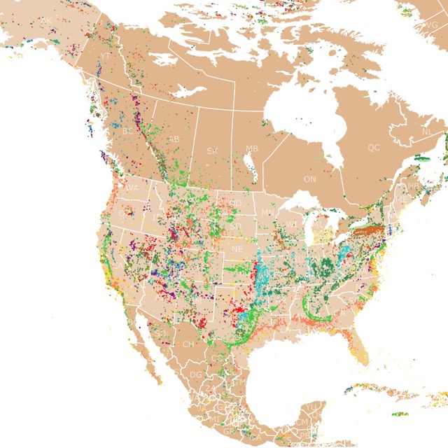
There are fossils spread throughout North America. To see where they are, visit this map of fossils
South Dakota's Public and Protected Areas
Badlands National Park
Badlands National Park is represented in red in the southwestern region of South Dakota.
The Badlands might be rugged, but their beauty draws visitors from worldwide. The Badlands are incredible geological deposits that contain one of the world's richest fossil beds.
The 244-thousand acres protect the mixed-grass prairies where bighorn sheep, prairie dogs, black-footed ferrets, and bison graze today. All year long, people visit the park to observe the wildlife that inhabits the area.
Badlands National Park is an excellent place to go for a scenic drive. The scenic drive takes about an hour or two, but the Badland buttes make visitors forget about time.
The badlands started forming 75 million years ago through the deposits left by shallow seas and rivers. Erosion took over 500,000 years ago and keeps going on today. The result is the beautiful sandstone formations with colorful layers that awe visitors that come to the park.
Sage Creek Rim Road is another scenic drive worth taking. Visitors get a different view of the Badlands, as this drive is by the Northern Unit.
Photographers love the incredible sunrises and sunsets. There are several excellent spots to capture the raw beauty of the sun setting and rising with the Badlands seemingly changing color.
The Junior Ranger Program is an excellent program for kids. The park offers a family-friendly adventure using GPS. It's a GPS scavenger hunt that teaches the kids about the area and park features. Once the quest is complete, the kids earn a patch.
At the Cedar Pass Amphitheater, visitors can view the night sky within the Badlands National Park. Every spring, summer, and fall, visitors come to learn about South Dakota's night sky.
Make sure you stop into the White River Visitor Center in the park's South Unit. There you will find maps, museum exhibits, and rangers you can talk to about the park's significance and Lakota heritage.
Visitors who love geology and paleontology might want to visit the Fossil Preparation Lab. Here they have the opportunity to speak directly with paleontologists about the fossils. The lab is only open to visitors during the summer, Badlands.
Wind Cave National Park
Wind Cave National Park is in southwestern South Dakota, represented in red.
Wind Cave offers the opportunity to watch bison, elk, and other wildlife roaming the prairie grasslands. Visitors can also trek through the forested hillsides of one of the United State's oldest national parks.
Wind Cave National Park has one of the most elaborate and lengthy caves worldwide. The park was named for the barometric winds at the cave's entrance.
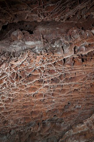
Visitors follow the maze of passages and discover boxwork. Boxwork is a unique and rare formation in which thin blades of calcite project from the ceiling and walls. The result is a honeycomb pattern whose origins are a mystery.
You don't have to set foot in Wind Cave to enjoy the park. Whether it's hiking, backcountry camping, or biking. Take a 20-mile driving tour to see the sights and learn about the geology in the area.
There are thousands of acres for horseback riding, camping, going on picnics, or wildlife observation.
While bringing your pets along isn't permitted when backcountry camping, many pet-friendly trails are available. Pets must be on a leash and in the designated areas, Wind Cave.
Would you love to find more caves? Visit this map of Caves in the USA
Custer State Park
Custer State Park is located in southwestern South Dakota. It is represented in lime green. The closest towns are Custer, Rapid City, Keystone, and Hill City.
This beautiful state park offers stunning views of the granite peaks and rolling plains. The beautiful mountain ranges and crystal clear mountain waters of Lake Sylvan are a delight. With over 70-thousand acres of land, there is a lot of ground to cover.
The park is home to 1,500 North American bison, turkeys, mule deer, antelope, elk, coyotes, burro, prairie dogs, and whitetail deer.
Visitors come to the park and enjoy many outdoor activities, including camping, biking, hiking, fishing, swimming, and a little rest-and-relaxation.
The park also has a museum and visitor center that offer excellent educational experiences.
The park is open year-round and has nine campgrounds with over 300 campsites, a horse camp, and cabins.
You'll find four private historic lodges with restaurants within the wildlife preserve. Visitors can also enjoy guided wildlife activities. If you're searching for something more modern, Custer State Park Resort has modernized cabins and hotel rooms, Custer State Park
Mount Rushmore National Memorial
Mount Rushmore National Memorial is located in southwestern South Dakota, is the red speck inside Norbeck Wildlife Preserve in green.
Mount Rushmore is a top-rated destination. A little over 2-million people visit the memorial every year.
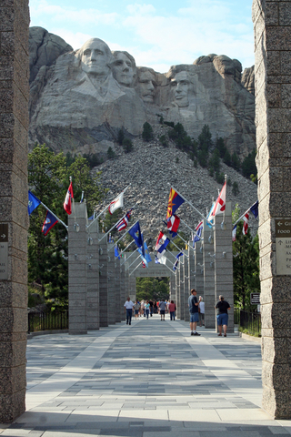
It's literally a piece of artwork sculpted on Mount Rushmore, boasting the massive faces of four well-known presidents.
Whether you only have a couple of hours to explore or the entire day, there's something interesting for all. The Lincoln Borglum Visitor Center is excellent for finding park info, educational films, a bookstore, and museum exhibits.
The Sculptor Studio provides a brief 15-minute talk about the carving process and the lives of the people who worked on the rock.
The Presidential Trail is perfect for a short mile walk. There are 422 stairs on the trail, allowing visitors the opportunity to get up close and personal with this massive sculpture, Mount Rushmore.
Hungry? Stop in Carvers Cafe, or get a cold treat at the ice cream shop. Don't forget to pick up a souvenir at the gift shop. Visitors can rent a self-guided audio tour of the park, or read the signs.
Interested in Prairies and where they are? Visit this map of World Grasslands
Hartford Beach State Park
Hartford Beach State Park is located in northeastern South Dakota on the border with Minnesota. The park is located 15 miles north of Milbank off of SD HWY 15.
The backdrop for Hartford Beach State Park is Big Stone Lake. The park is popular for camping, picnics, and various outdoor activities.
The Ancient River Warren was formed by the runoff from melting glaciers. A portion of the river is now known as Big Stone Lake.
The rugged bluffs strewn with rocks and beautiful timbered shorelines are picturesque. Hartford Beach State Park is open year-round, offering 87 campsites and 4 cabins for visitors to spend a weekend.
Hiking, camping, birdwatching, canoeing, disc golf, and geocaching are a few activities visitors enjoy. Visitors can also rent skis, paddleboards, and kayaks at the park.
Hartford Beach also has an array of items you can check out and enjoy, including lawn games, volleyball, snowshoes, disc golf, fishing poles, and horseshoes, Hartford Beach.
Fort Pierre National Grassland
Fort Pierre National Grassland is a large green square situated in north-central South Dakota, south of Fort Pierre and west of the Lower Brule Indian Reservation.
The features of the land range from flat land to gently rolling hills. The extensive drainage systems allow water to flow down to the Missouri and Bad Rivers.
The grasslands contain drainages that have been dammed, creating several small to medium-sized ponds that provide fresh water to the wildlife. The ponds are home to fisheries and waterfowl.
Birdwatchers and wildlife lovers visit Fort Pierre Grasslands for the diverse habitats that different species call home. Badgers, rattlesnakes, deer, antelope, jackrabbits, and bird species can be spotted throughout the grasslands.
It is not just animals that attract visitors. When spring and summer hits, the Grassland blooms to life with beautiful wildflowers, breezy grasses, and an assortment of wildlife.
Camping, fishing, and hunting (with proper permits and licenses) are a few outdoor activities visitors enjoy.
Dispersed camping is permitted at the park, but if you're looking for modern sleep accommodations, you'll have to look nearby Fort Perre.
Want to find places to explore in nearby Wyoming? Check this map of Wyoming Parks
Jewel Cave National Monument
Jewel Cave National Monument is in southwestern South Dakota, close to the border of Wyoming and surrounded by the Black Hills National Forest.
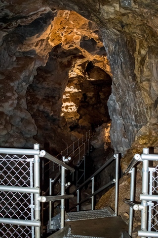
Jewel Cave is huge. A team of explorers mapped the area a while back and reached the 200th mile. There are over 3,000 feet (914.4 meters) of passages!
While some caves are carved out by underground rivers, Jewel Cave is not. According to NPS, "Jewel Cave was formed by slowly-circulating, acid-rich groundwater," which is unique.
Jewel Cave might not be the most extensive cave, but it's on the list of the longest caves in the United States, Jewel Cave.
Visitors can enjoy the guided tours, hiking trails, and the Historic Lantern Tour.
The cave is characterized by calcite crystals, strands of gypsum, and scattered boulders!
Affiliate Disclosure
Databayou.com is a participant in the Amazon Services LLC Associates Program, an affiliate advertising program designed to provide a means for sites to earn advertising fees by advertising and linking to Amazon.com. Databayou.com also participates in affiliate programs with Clickbank, CJ, and other sites.
If you plan on visiting one of South Dakota's prairies, badlands, or caves, I suggest you get some of these items found on Amazon.
- Emergency Survival Kit: This kit includes first aid items, hatchet, folding shovel, military knife, blanket, whistle, and more in a lightweight bag.
- LED headlamp: A rechargeable lamp is ideal for hiking and camping after dark.
- Hiking Boots: For long hikes and cave exploration.
FOLLOW ME
Resources for South Dakota's Protected Areas Map
The shapefiles with South Dakota's state boundary lines, lakes, major rivers, and cities were downloaded from Natural Earth Data.
The Parks and Public Lands shapefiles for South Dakota were downloaded from USGS.
This map will be updated with new data! To receive updates on this and more nature maps, join my email list!!!!!!!
Made by Luz K. Molina with D3.js.