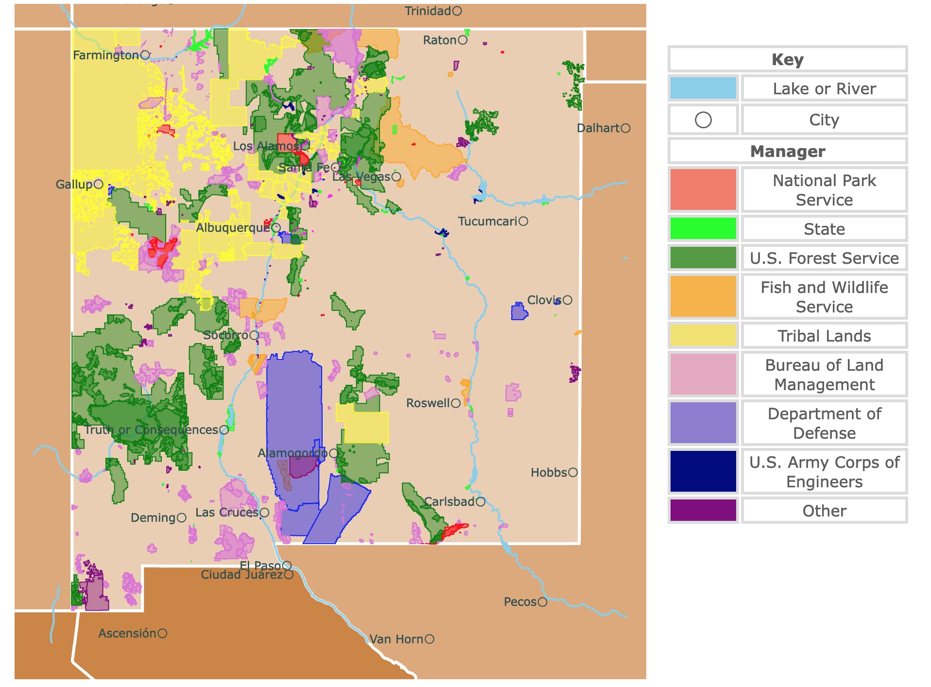
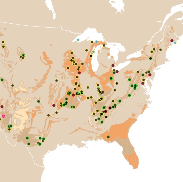
Map of New Mexico's Protected Areas
This interactive map shows the Locations, Names, Areas, and Details of National Parks, State Parks, National Forests, Tribal, and other Public Lands of New Mexico. It also shows major cities and rivers for context. For more detail, zoom in. For more information, hover over the map, or scroll down.
| Key | |
|---|---|
| Lake or River | |
| ◯ | City |
| Manager | |
| National Park Service | |
| State | |
| U.S. Forest Service | |
| Fish and Wildlife Service | |
| Tribal Lands | |
| Bureau of Land Management | |
| Department of Defense | |
| U.S. Army Corps of Engineers | |
| Other | |
New Mexico's Geography
New Mexico is the fifth-largest state in the US, with over 121-thousand square miles!
New Mexico consists of four land regions: the Colorado Plateau, the Great Plains, the Rocky Mountains, and the Range and Basin region.
The third eastern portion of New Mexico is covered by the beautiful Great Plains prairies, which run from a high plateau in the north down to the Pecos River in the south. Over time, the rivers in the high plateau cut deep canyons into the landscape.
South of the Canadian River and along the eastern edge of New Mexico, the lands are referred to as Staked Plains or High Plains.
To the northwest, the Colorado Plateau is a rugged area with wide basins, sharp cliffs, deep canyons, and flat-topped hills or mesas. The Continental Divide runs through the plateau and streams west of the Divide, draining into the Pacific Ocean.
The north-central portion of the state is covered by several mountain ranges that are a part of the Rocky Mountains. The Rio Grande River cuts through the mountains, north to south. To the East of the Rio Grande is the Sangre de Cristo Mountain Range.
Wheeler Peak is in the Sangre de Cristo mountain range, which is the southernmost area of the Rocky Mountain Range. The highest point in New Mexico is Wheeler Peak which is 13,161 feet (4,011 meters) above sea level.
To the west of the Rio Grande, you'll find the Jamez and Nacimiento Mountain ranges. The melting snow from the Rockies helps provide moisture every spring for the irrigated crops in the Valley.
The Basin and Range region covers about 1/3 of the state and is to the south of the Rockies region. This area extends south around Santa Fe to Mexico and west to the state of Arizona.
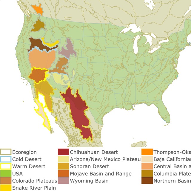
In case you want to learn more about deserts in the U.S. check this map!
New Mexico's Climate
The weather and climate in New Mexico are enjoyable most of the year. It has an arid or semiarid, mild continental climate that's characterized by light precipitation.
An abundance of sunshine blesses the land and the low relative humidity, but it can be a challenging environment for some people.
The average temperature in New Mexico is around the mid-50s (12 degrees Celsius). Extreme temperatures can reach 120 degrees Fahrenheit (48 degrees Celsius), and they can drop as low as the -50s (-46 degrees Celsius).
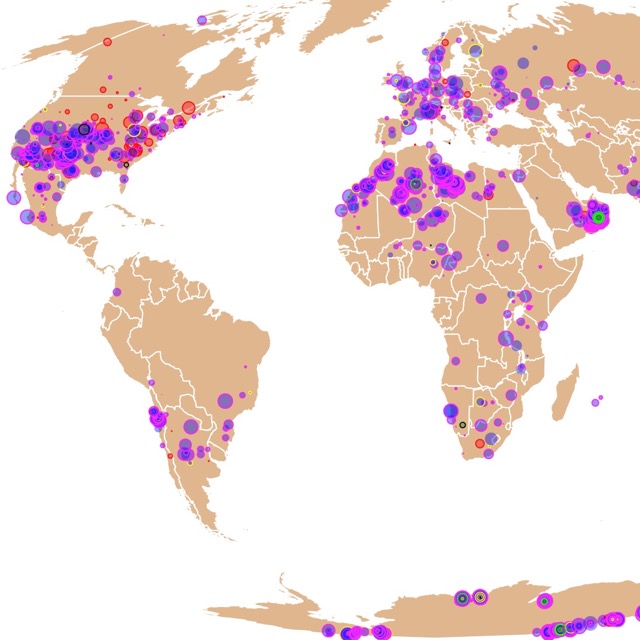
There is more than desert and rocks in New Mexico. It is a great place to see shooting stars and find meteorites. For more infomation click on this map of Meteorite Landings!
New Mexico's Plants and Animals
The animals and wildlife of New Mexico are rather diverse. It's actually one of the more biologically diverse areas in the nation. There are over 4,000 different species of plants and animals in the state.
The habitats in New Mexico include coniferous forests, woodlands, grasslands, alpine tundra, desert shrubland, and riparian areas, USDA.
The plant life of New Mexico consists mainly of hearty, drought-resistant plants and trees, including juniper Douglass fir, cottonwood, Russian Olive, and blue spruce. You will also notice low-growing plants like the sagebrush, prickly pear cactus, and Russian thistle (tumbleweed).
The state is home to wolves, coyotes, foxes, mountain lions, squirrels, and many other mammals. Bird watching is exceptional as there are many species in the area.
New Mexico's National Park Service Areas
Carlsbad Caverns National Park and Wilderness
Carlsbad Caverns Wilderness is represented as a red polygon on the state's southern border.
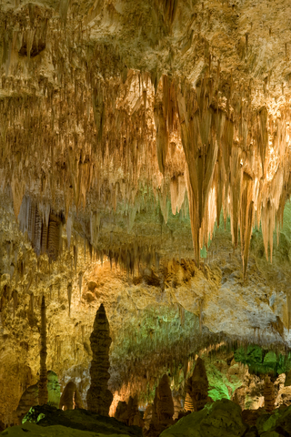
One of the main reasons this area is so popular is because of all the caves. There are currently over 100 documented caves, including the world-famous Carlsbad Cavern and Lechuguilla Cave. These caves are over 125 miles long!
Carlsbad Caverns offers more than 40 miles of beautiful hiking trails. The terrain is rugged, so you'll want to make sure you have good gear. The Guadalupe Ridge Trail, which is an old abandoned dirt road, follows the edge of the wilderness area to the northwest.
You can explore the caverns at your own pace or enjoy a guided tour with a ranger. The Dawn of the Bats Program , allows you to view hundreds of thousands of Brazilian free-tailed bats, taking the flight out of the caverns every evening.
The bats call the caverns home through April and October before they migrate for the winter. Every year on the 3rd Saturday of July, groups of onlookers gather to watch the bats return home. This is a spectacular event!
The Night Sky Programs take place a few days in October. Participants walk about 1/2 a mile (0.08km) for Star Walks and meteor shower viewing.
If you're willing to walk a bit further, you can experience Moon Hikes on a desert trail. The programs are free to attend, but they're limited to a first-come-first-serve basis.
Book a campground and camp nearby. The visitor center at the Caverns Wilderness has a cafeteria, exhibits, a gift shop, a bookstore, and an area where you can view the park's film.
Interested in Caves? Check this map of Caves in the USA
Valles Caldera National Preserve
Valles Caldera National Preserve is northwest of Los Alamos, New Mexico.
The diverse landscape of this area wouldn't be what it is if a volcanic eruption didn't take place over a million years ago.
The spectacular explosion created a circular depression 13 miles wide, which is known as the Valles Caldera, NM Natural History.
This national preserve is known for the vast mountain meadows, meandering streams, and incredible wildlife. Not only does the area preserve the plants and nature, but it preserves the homeland of the ancestral natives that once lived in the area.
Explore the backcountry, hike, bike, take stunning photos, and so much more. The wildlife of Valles Caldera consists of prairie dogs, elk, badgers, black bears, and golden eagles.
The backcountry is accessible by vehicle, foot, bike, and horse. You'll just have to check and see how you would access the area via your preferred method.
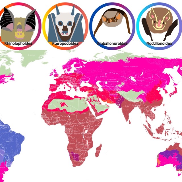
Bats are not just cave dwellers. They are an important part of New Mexico's ecosystems. To learn more, visit this map of Bats Geographic Range
Petroglyph National Monument
Petroglyph National Monument is next to Albuquerque and is represented in red on the map.
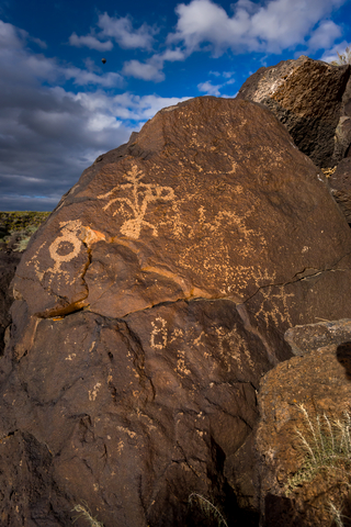
This National Monument protects one of the largest petroglyph sites in the United States. The symbols and designs were carved onto the volcanic rocks by the Native American and Spanish settlers between 400 to 700 years ago.
The Monument has set hours at each location, so be sure to watch out for that. The Boca Negra Canyon allows you to see 100 petroglyphs. At Rinconada Canyon, you can hike a 2.2-mile loop to check out 300 ancient petroglyphs.
Piedras Marcadas Canyon has the most petroglyphs, with 400 to view along a 1.5-mile round trip hike. Petroglyph
Dogs are allowed in all areas except Boca Negra Canyon. Dogs must be on a leash no longer than 6-feet.
Take a trip and explore the cinder cone volcanoes between 9 a.m. and 5 p.m every day, unless there is severe weather. After hours you are allowed to view the site from the parking lot.
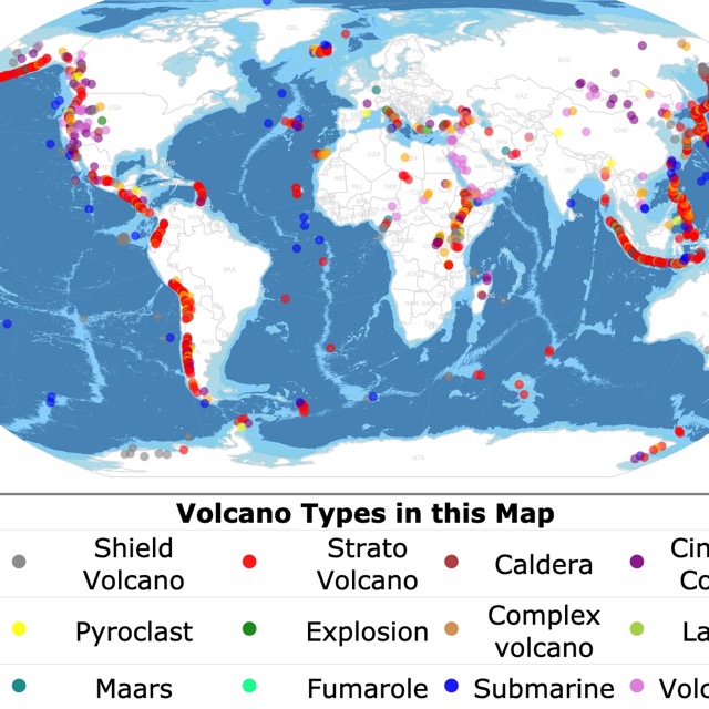
Want to learn what is a cinder volcano? Check this map of World Volcanoes!
New Mexico State Parks
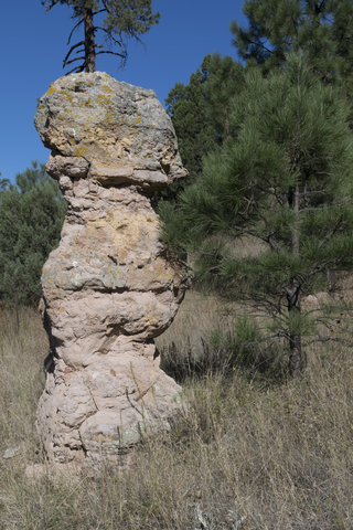
City of Rocks State Park
City of Rocks State Park is the lime green square, located about halfway between Deming and Silver City.
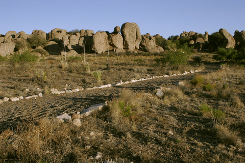
The City of Rocks State Park didn't get its name from any old rocks on the ground. The volcanic rock formations are how the park is called what it is.
The park covers a one-square-mile area in the Chihuahuan desert region in southwestern New Mexico. The site is a natural geological formation composed of massive, sculpted rock columns or pinnacles that rise as high as 40 feet (12 meters). The rock formations are separated by lanes or paths that resemble city streets.
A large volcano erupted, forming the rocks over 30 million years ago. The erosion that took place over those millions of years helped slowly sculpt the columns we see today. One look at the rocks might have you thinking you're on another planet.
The park offers campsites, incredible hiking trails, mountain biking, wildlife viewing, birdwatching, stargazing, picnic spots, and a beautiful desert botanical garden.
The Visitor Center is uniquely designed and includes a large display area. They have restrooms with hot showers, which isn't common in visitor centers.
New Mexico Public and Protected Lands
Kasha-Katuwe Tent Rocks National Monument
Kasha-Katuwe Tent Rocks National Monument is situated west of Santa Fe, and it's depicted in pink on the map.
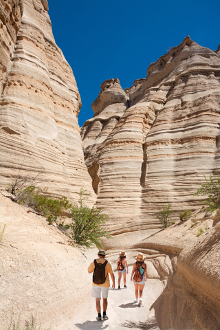
The Kasha-Katuwe Tent Rocks National Monument is an incredible outdoor laboratory. Here, visitors have an opportunity to observe, study, and experience the geological processes that naturally shape landscapes.
On the Pajarito Plateau in north-central New Mexico, the Monument includes a beautiful national recreation trail. It ranges from 5,570 feet (1,697 meters) up to 6,760 feet (2,060 meters) above sea level.
You can only travel the Pajarito Plateau area on foot. There are two segments providing opportunities for hiking, birdwatching, plant identification, and geological observation.
The cone-shaped tent rock formations are the result of volcanic eruptions that took place over 6 million years ago, leaving pumice, ash, and tuff deposits over a thousand feet (304 meters) thick.
The massive explosions of the Jemez volcanic field spewed out pyroclasts, all the while searing hot gasses blasted down the slopes in a pyroclastic flow, National Geographic.
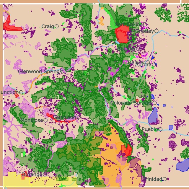
Want to find places to explore in nearby Colorado? Check this map of Colorado Parks
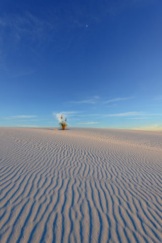
White Sands National Monument
The White Sands National Monument is the red polygon in southern New Mexico. It is situated within the White Sands Missile Range.
Non-military personnel is allowed to visit the Monument. However, non-military are not permitted at the missile range.
The White Sands National Monument rises out of the heart of the Tularosa Basin. It is one of the world's natural wonders. It isn't everywhere that you can see glistening white sand!
The incredible wave-like dunes of gypsum sand have enveloped 275 square miles of the desert, creating the world's largest gypsum dune field!
Enjoy a spectacular bike ride on the Dunes Drive. Bikes are not permitted off of the Dunes Drives. An eight-mile scenic drive is a choice for many, which leads people into the heart of the gypsum dune field.
Backcountry camping is permitted at the Monument. Fair warning, the dunes are ever-changing, so the area might look slightly different when you wake up in the morning. If you have a horse, bring it along and enjoy some scenic horseback riding!
Take a walk on the wild side and spend the day sand sledding down the beautiful gypsum dunes. It might not be snow, but you can still sled and even sandboard down the dunes. Join a ranger program to learn more about the White Sands National Monument and its diversity, White Sands.
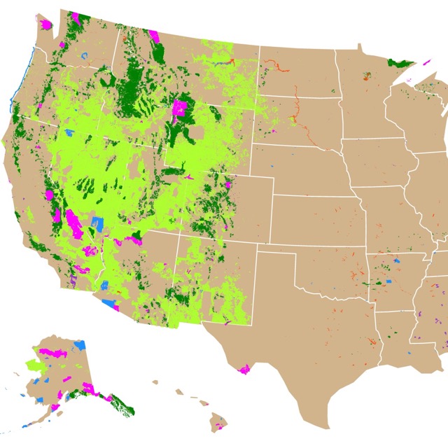
New Mexico has more than National and State Parks for visitors. To learn more check about different protected lands, visit this map of Public Lands in the U.S.A.
Bosque del Apache National Wildlife Refuge
The Bosque del Apache National Wildlife Refuge is south of Socorro and is depicted in orange. The Wildlife Refuge consists of over 57-thousand acres located along the Rio Grande.
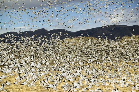
Every year in November, the Festival of the Cranes takes place at the refuge. It's a birdwatcher's dream come true, Bosque del Apache.
The refuge has seasonal wetlands that attract migratory birds year-round, including the sandhill cranes, the most cherished bird in the area.
Some of the activities one can enjoy at the Bosque del Apache National Wildlife Refuge, besides the Festival of the Cranes, including refuge tours, biology, birds, geology, and art workshops. Lectures are offered covering a variety of wildlife-related subjects.
Listen in on topics covering bird identification, photography, and wildlife painting.
If you're not afraid to take to the skies, you could have the opportunity to enjoy a hot air balloon ride. What better way to view the birds than in their element? If you prefer to keep your feet on the ground, that's ok; you can go hiking on the nature trails.
With the proper permit, you can hunt in designated areas, go fishing, and even frogging. Keep your eye out for the special events that come and go; you never know what exciting stuff might go down.
If you're not into roughing it on a camping trip, a Birdwatching RV park is not too far from the wildlife refuge.
Affiliate Disclosure
Databayou.com is a participant in the Amazon Services LLC Associates Program, an affiliate advertising program designed to provide a means for sites to earn advertising fees by advertising and linking to Amazon.com. Databayou.com also participates in affiliate programs with Clickbank, CJ, and other sites.
If you plan on visiting one of these parks or hiking around New Mexico, I suggest you get some of these items found on Amazon.
- Binoculars with Phone Adapter: High Power Binoculars with BaK4 prisms, Lightweight, and Waterproof, Perfect for Bird Watching or Stargazing.
- CamelBak, Hydration Pack: This comfortable vest and pack holds 2 Liter of water and is designed for quick loading and refilling.
- Victorinox Swiss Army Huntsman Pocket Knife (Red): An army knife always comes in handy. You never know what you will find or need in remote areas.
Follow Me
Resources for New Mexico's Protected Areas Map
The shapefiles with New Mexico's state boundary lines, major rivers, and cities were downloaded from Natural Earth Data.
The Parks and Public Lands shapefiles for New Mexico were downloaded from USGS.
This map will be updated with new data! To receive updates on this and more nature maps, join my email list!!!!!!!
Made by Luz K. Molina with D3.js.