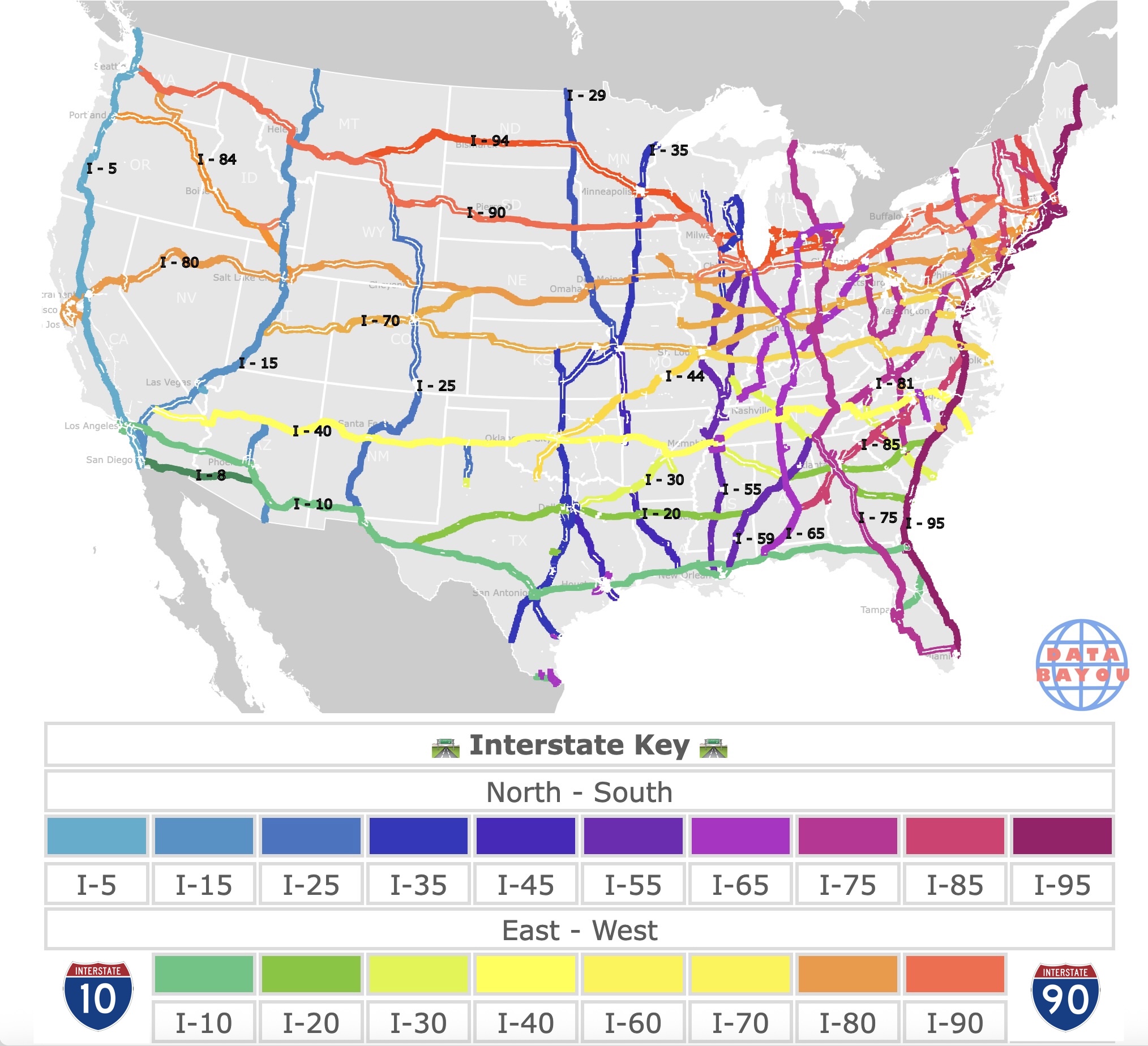
Map of Interstates in the U.S.A.
This is an interactive map of the Interstate Highway system and major motorways within the continental United States. Blue, purple, and red colors represent Interstates highways that go north - south. Green, yellow, and orange represent Interstate highways heading East - West. On top of the Interstates there are some major motorways represented in white. For name and type, hover over the map. For more detail, zoom in. For more information, scroll down.
| 🛣 Interstate Key 🛣 | |||||||||
|---|---|---|---|---|---|---|---|---|---|
| North - South | |||||||||
| . | |||||||||
| I-5 | I-15 | I-25 | I-35 | I-45 | I-55 | I-65 | I-75 | I-85 | I-95 |
| East - West | |||||||||
| . | |||||||||
| I-10 | I-20 | I-30 | I-40 | I-70 | I-80 | I-90 | |||
U.S. Interstate Highways
The U.S. Interstate Highway network is based on a grid, with even-numbered routes running east to west, and odd numbered routes running north to south.
Lower-numbered routes are in the southwest, while higher numbered routes are in the northeast.
The primary highways are assigned one- or two-digit route numbers, whereas their associated auxiliary Interstate Highways receive three-digit route numbers.
For example, between Georgia and Alabama, shown in crimson color, you will find I-85 and its auxiliary I-185.
As you hover over over the map you will find more similar examples.
This map shows Data Centers in the U.S.
U.S. Highways and Motorways
The Interstate numbering system is the inverse of the preexisting US Numbered Highway System.
Nevertheless, some Interstates such as 50 and 60 do not exist to avoid conflict with US Highways of the same numbers running through the same states.
You can find US Highway 50 as a white line on I-70 in Utah.
Route Types
Besides depicting Interstates, this map also depicts other major motorways. Below is a table with the code and its description. Source: Census.gov
| Route Type Code Route | Type Code Description |
|---|---|
| C | County |
| I | Interstate |
| M | Common Name |
| O | Other |
| S | State recognized |
| U | US |
U.S. Interstate Highways Facts
- The Interstate system has 71 primary Interstate Highways.
- As of 2022, the Interstate Highway System had a total length of 48,890 mi (78,680 km). Source: DOT.
- The states with the longest Interstate networks are Texas, California, Illinois, Pennsylvania, and Ohio, in that order.
- The official name of the Interstate System is the Dwight D. Eisenhower National System of Interstate and Defense Highways. It is also called the Eisenhower Interstate System for short.
- Airplanes occasionally land on Interstates when no alternative is available in an emergency, not because the Interstates are designed for that purpose.
- Many Interstates, including beltways and spurs, are located entirely in one State and serve primarily intra-State traffic. They don't necessarily cross state lines.
- Alaska, Hawaii, and Puerto Rico also have Interstate Highways.
- The Federal Government provided 90 percent of the funds; the Interstate System was built by the States, which own and operate it.

If you want to have a printed map of the Interstate system to guide you while driving, Amazon offers the National Geographic Road Atlas 2026: Adventure Edition [United States, Canada, Mexico].
This guide is the ideal companion for the next time you hit the road. It includes major cities and metropolitan areas shown in detail with inset maps that include popular attractions, infrastructure, and points-of-interest.
Longest Interstates
Here is a list of the longest Interstate Highways in the U.S. Source: Go Freight.
- Interstate 90: 3,101.77 miles (4,862 Km), east coast to west coast
- Interstate 10: 2,460.34 miles (3,959 Km), from Florida to California
- Interstate 70: 2,153.13 miles (3,465 Km), from Utah to Maryland
- Interstate 95: 1,908.74 miles (3,071 Km), from Miami to the Canadian border in Maine
- Interstate 94: 1,585.20 miles (2,550 Km), from Montana to Michigan
To learn more about the construction of the interstate system, Amazon has Divided Highways: Building the Interstate Highways, Transforming American Life. In Divided Highways, Tom Lewis offers an encompassing account of highway development in the United States.

This map shows you where are the Museums in the U.S.
Speed Limit on Interstates

Every state determines the speed limit on its Interstates. Most states have speed limits of 65mph or 70mph in Rural Areas.
States out west may have speed limits of 80mph.
Texas has speed limits of 85mph in some areas.
Speed limits may vary depending on location. Interstates in urban areas have speed limits of around 55 and 60mph.
Trucks may also have lower speed limits on specified segments of the road. IIHS
Interstate Highway History
The modern Interstate System was largely inspired by President Dwight D. Eisenhower. During World War II, Eisenhower was impressed by Germany’s Autobahn network—efficient, durable highways that supported both military and civilian mobility.
After the war, he became convinced that a similar system was essential for national defense, economic growth, and public safety.
On June 29, 1956, Eisenhower signed the Federal-Aid Highway Act, which officially launched the Interstate Highway System. The act authorized $25 billion for the construction of 41,000 miles of highway over 13 years—then the largest public works project in American history.

Funding came primarily from a Highway Trust Fund, financed through a federal fuel tax.
Construction began in the late 1950s and continued for decades. The system was built to uniform standards: controlled access, multiple lanes, and no at-grade intersections.
Engineers had to overcome major challenges, including mountainous terrain, dense urban areas, and environmental concerns.
The system was declared “complete” in 1992 with the opening of I-70 through Glenwood Canyon, Colorado, though construction and improvements continue to this day. Source: DOT.
Follow Me
Resources for Interstate Highways in the United States
The shapefiles with Interstates are from the U.S. Census.
The shapefiles for the states on this map were downloaded from Natural Earth.
Made by Luz K. with D3.js.