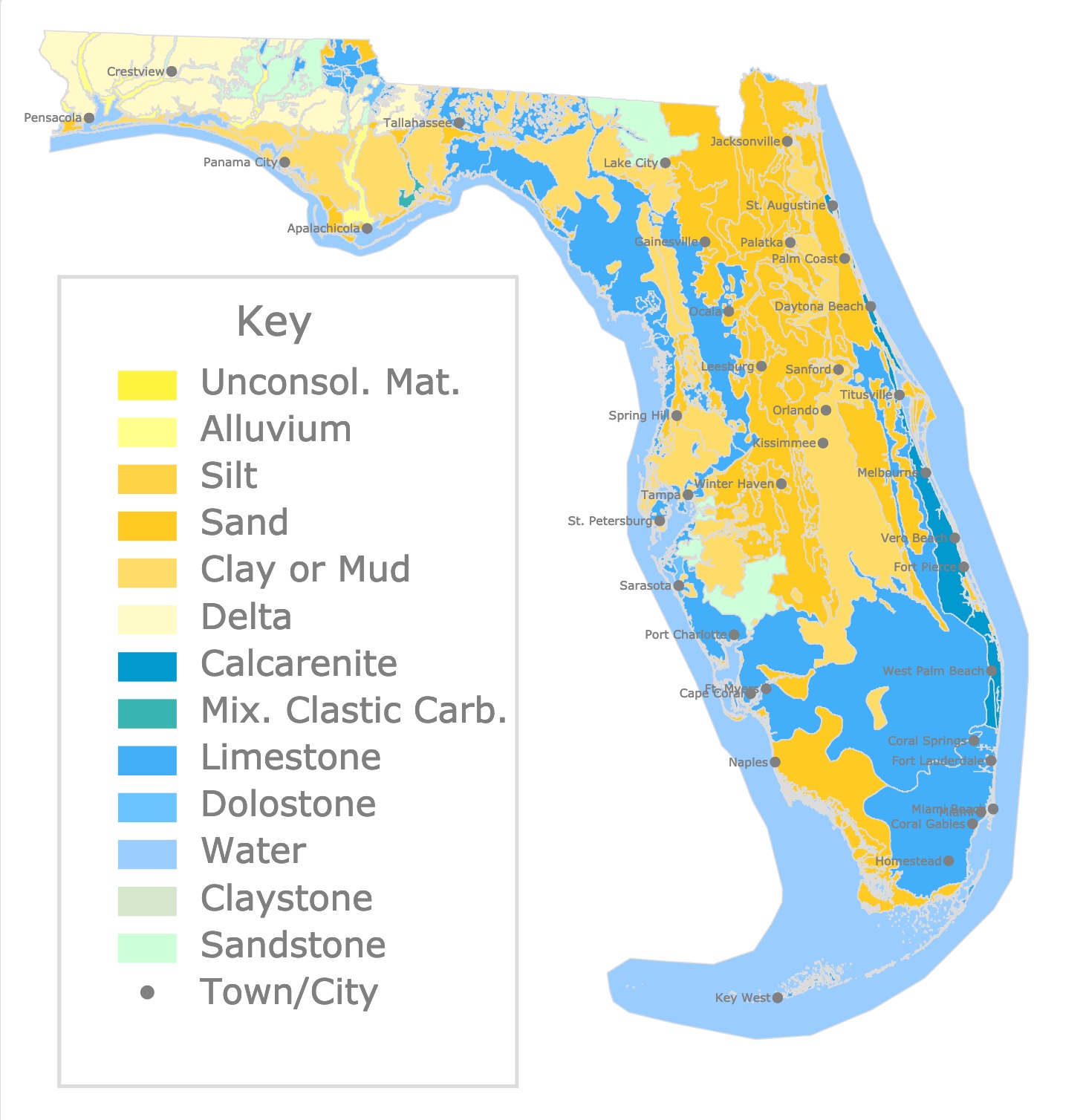
This interactive map shows the geologic units or formations of Florida. The different colors show the rock types of each area. To get detailed information about the rocks, formation, and epoch of origin, hover over each geologic unit on the map.
Geology and Florida Springs
While making the Florida Springs Map, Florida Caves Map, and Florida Parks Map it was clear that all sites required a resource to explain terminology and origin of Florida's bedrock. A site that would explain: How are Springs, Sinks, and Caves formed?, Why Florida has so many springs?, Where in Florida are springs and sinks concentrated?
Below is a compilation of some geology terms, basic geology of Florida, and answers to the previous questions.
Formation of Florida
The Florida limestone plateau formed millions of years ago when the area was a warm shallow sea. Millions of years of small sea creatures accumulated as deposits, and formed the limestone. Today, this limestone is several thousand feet thick.
When sea creatures like shells and corals die, they leave behind calcium carbonate or limestone. As their bodies sink and build up on the bottom of the seafloor, their remnants fossilize and calcify.
Florida limestone is relatively new, with only 50-60 million years. Florida limestone is also very soft and very white.
On top of that limestone formed a layer called Hawthorn Formation. This is a clay layer, which water cannot permeate. It basically blocks water.
The Hawthorn formation is very thick in some places. This places generally lack karst features like sinkholes, springs, and caves. Source: floridacavediving.com
In other places the clay and soil are very thin. The limestone bedrock is close to the surface and karst features like caves are easy to access.
On this map orange and yellow areas are limestone, and blue and light blue areas are mainly Hawthorn formations. Springs, caves, and sinks are present in these yellow, orange limestone formations.
Florida has a plethora of springs because the State terrain is based on thick layers of limestone and dolomite. These rocks dissolve easily with water that is slightly acidic. This occurs once the rainwater seeps through the ground.
Rainwater is slightly acidic due to Carbon dioxide. When the water goes underground it creates cavities and caves.
The result is a landform called Karst. This landform is defined by the presence of springs and sinkholes and the lack of a developed surface drainage system.
Instead most of the drainage goes to the rocks of the Floridian aquifer system.
Springs are formed when the ground water under pressure flows through a natural opening.
Karst Fenster
Falmouth Springs, west of Tallahassee, has been called the shortest river in the world. It is actually the roofless portion of a cavern from an underground stream.
This is common in different springs and creeks throughout Florida.
As mentioned before, because the caves and caverns are made of limestone, gypsum and dolomite rocks, they get eroded and collapse Atlas obscura.
Examples are Devil's Den, Mineral Springs, Paradise Springs.
Rainwater and Springs
The source of spring water in Florida is rain water.
Rainfall infiltrates the ground to replenish the aquifers. Unlike what some believe, the water does not come from other Georgia or Alabama. It is all absorbed through the ground. Source: Springs of Florida.
A river rise is a place where a sinking stream reappears.
Water in river rises, resemble water from nearby sinking streams.
This type of feature makes rivers look like they disappear and reappear a few miles away.
The river flows to a River Sink to become part of the Florida aquifer system. Miles away the River reappears and continues its way to the outflow Florida State Parks.
Most of Florida's dark tannic springs are actually River Rises.
Tannins are biomolecules produced by plants. Their presence indicate presence of plants and therefore, come from surface areas, not underground. Florida's Springs.
Some examples of these are Santa Fe River Rise, the Nutall River Rise, the Aucilla River, St. Marks Rise, and Holton Creek Rise.
"The St. Marks River Rise is a re-emergence of the St. Marks River below the Natural Bridge Battlefield Historic State Park. The river gains a significant increased flow at the rise due to additional groundwater contribution, which averages 353 cubic feet per second or 228 million gallons per day. This first magnitude spring’s vent is located about a half-mile south of where the St. Marks River sinks into a swallet at Natural Bridge". As mentioned before, because it is a rise, water is not blue but brownish NWFWATER.
To establish the relationship between a river sink and a river rise, scientists pour around 100 pounds of fluorescein dye. Then they monitor the plausible rise to detect if the dye comes out again.
This experiment was done at the Dead River swallet, and it took 8 days to reappear at the Alapaha Rise and 10 days to reappear at the nearby Holton Creek Rise Florida Springs Institute.
The amount and type of spring quality depends on the activities that occur in the spring basins.
Water pollution is a major threat to springs in Florida.
The oil on roads, pesticides in gardens, fertilizers in crops go through seepage into the ground. Besides, septic tanks may contribute to nutrients, bacteria, and chemicals that reach the underground water.
Water will penetrate at different rates and reach underground in a matter of days or years. But the water that reaches groundwater through sinkholes, and sinking streams will reach the aquifer in a matter of days. These areas make them extremely vulnerable to contamination: Florida's Springs.