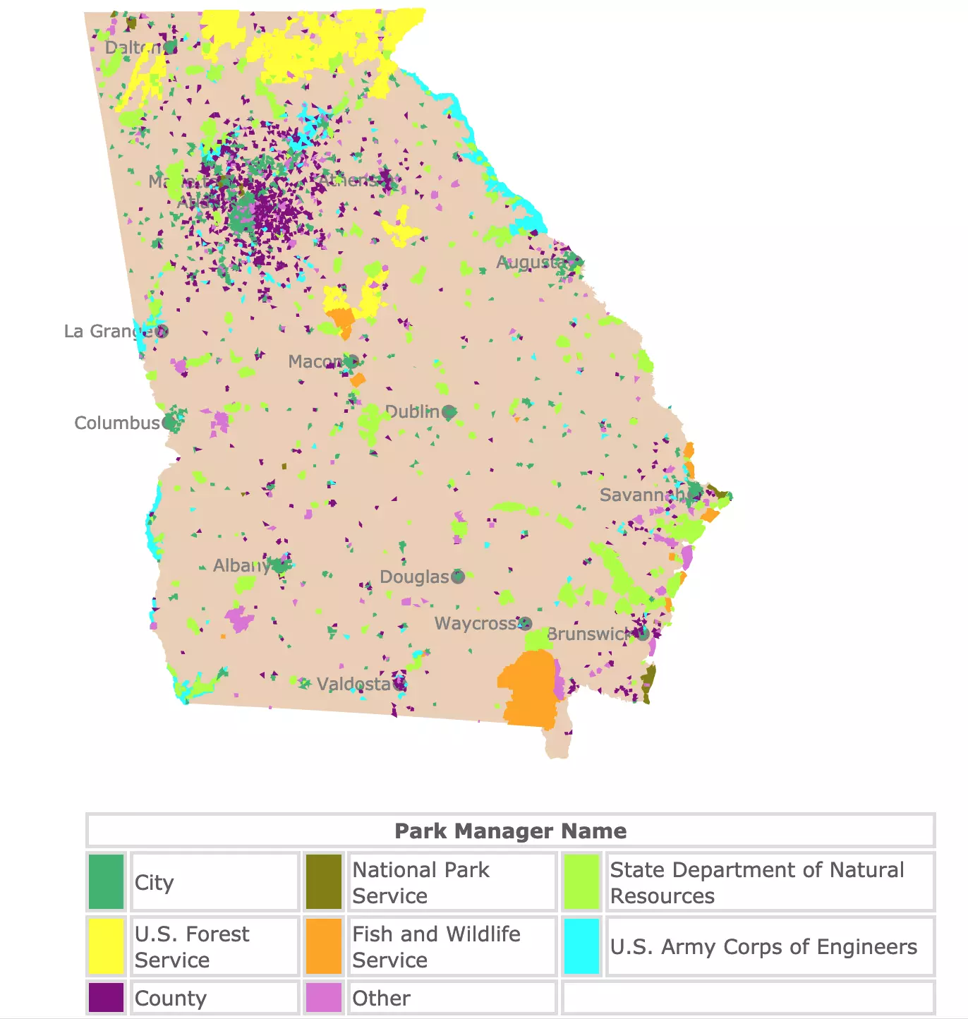
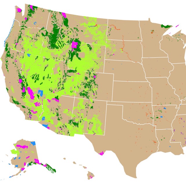
Map of Georgia Parks
This interactive map shows the Locations, Names, Area, and details of National Parks, State Parks, National Forests, City Parks, County Parks, and Wildlife Management Areas in Georgia. It also shows major cities for context. For more detail, zoom in. For more information hover over the map, or scroll down.
| Park Manager Name | |||||
|---|---|---|---|---|---|
| City | |||||
| National Park Service | |||||
| State Department of Natural Resources | |||||
| U.S. Forest Service | |||||
| Fish and Wildlife Service | |||||
| U.S. Army Corps of Engineers | |||||
| County | |||||
| Other | |||||
Georgia Parks and Natural Areas
Georgia is home to 13 units of the National Park Service. Most of them are historic sites, remnants of the American Civil War.
The "Peach State" is also home to 63 State Parks. These parks are mainly for the enjoyment of nature and recreation. From these 63 state parks, more than 40 offer camping sites.
One special park is Indian Springs State Park, located in the Middle of Georgia. This park was established as a public recreation area in 1926, thus making Indian Springs the oldest state owned recreational area in the country!
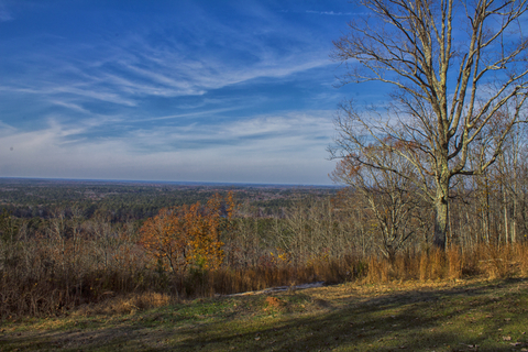
Because of Georgia's unique geographic location, and geologic history, the state's topography is quite diverse.
Georgia shares borders to the north with North Carolina, and Tennessee. To the west with Alabama, to the south with Florida, to the east with the Atlantic Ocean and South Carolina.
Georgia's landscape has amazing and unique features clustered in a small area. The northern region has rugged terrain and mountains; the southern region has coastal plains. These result in a state that has valleys, canyons, waterfalls, swamps, springs, and more.
There are different activities you can enjoy in Georgia Natural Areas. For more ideas check this map of Lazy Rivers in Georgia to go tubing.
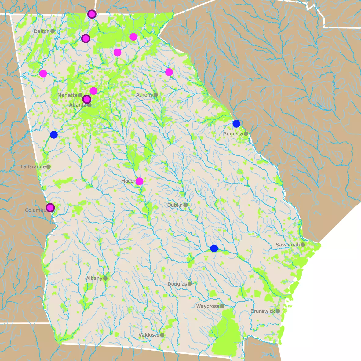
Georgia National Parks, State Parks, and Public Lands Map
At first the distribution of parks on the map might look random, but if you look closely, there are some predictable patterns.
State parks, colored in lime green; are usually close to cities. This is common for state parks around the country. State parks are medium expanses of land, supposed to provide recreation in natural settings, not far from urban areas.
There is also a high concentration of city parks (colored sea green) inside major cities. This is because cities are in charge of managing these small recreational areas inside cities.
Just like city parks, it is noticeable the high number of county parks, in purple, near Atlanta. Counties are definitely active on providing this large metro area, with plenty of space for leisure.
The largest swath of land (in yellow), north of the state, belongs to Chattahoochee National Forest. As most National Forests the USFS manages large areas for different uses, not just relaxation, but biodiversity preservation, and logging.
The US Army Corps of Engineers land, is adjacent to the Savannah River and the Chattahoochee River, since their most visible civil works include: planning, designing, building, and operating locks and dams.
The size and shape of the parks have been exaggerated, and slightly distorted to be more conspicuous, since many are very small.
If you would like to have a large map of Georgia with its Parks and Natural areas I suggest you look at this poster found on Amazon: Georgia State Parks & Federal Lands Map, 18x24 Poster.
Best Parks of Georgia
Looking into the best parks in Georgia, I found that Georgia's natural landscape was so cherished, that the state had its own list of Natural Wonders. There was no need to look any further, the best way to start the list is with Georgia's Seven Natural Wonders.
Seven Natural Wonders of Georgia
With so much beauty in one state, Ella May Thornton compiled the first list of Seven Natural Wonders of Georgia in 1926. She did it as a librarian at Georgia State Library in Atlanta, in response to an enquiry by a journalist; Forbes
The list is still relevant since the sites are still beautiful and the parks worthy of visiting. For more information about each one, read below.
- Stone Mountain
- Okefenokee Swamp
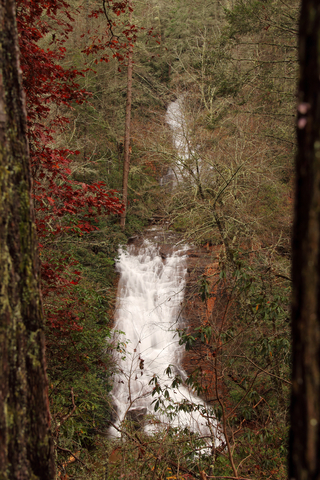
- Amicalola Falls
- Tallulah Gorge
- Warm Springs
- Providence Canyon
- Radium Springs
The original list included Jekyll Island Forest and the marble deposits in Pickens County. These have been replaced since, with Providence Canyon near Columbus, and Radium Springs near Albany.
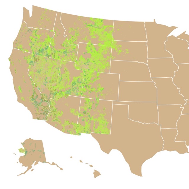
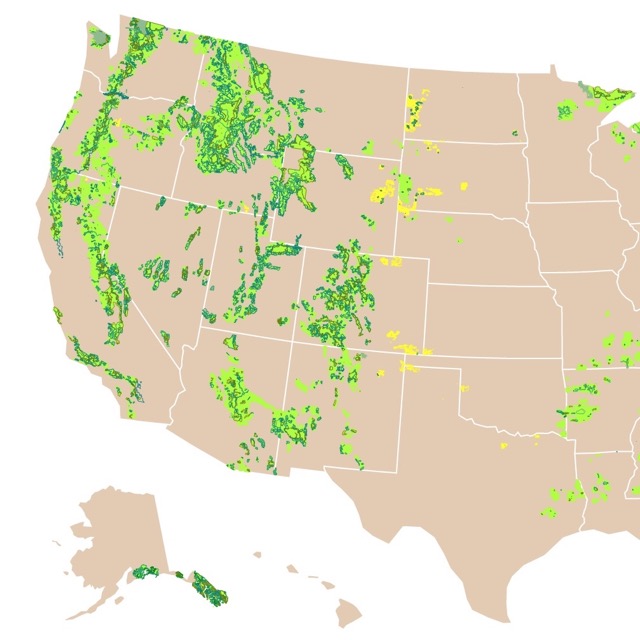
There is more than State Parks and National Parks to explore nature. This map shows you the Bureau of Land Management areas!
Stone Mountain
Situated 25 miles East of Atlanta, Stone Mountain has 3,200 acres, and it is managed by the City of Stone Mountain. You can find it by its sea green color.
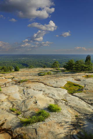
Stone Mountain itself is an imposing feature 1,683 feet (513m), with a circumference of 3.8 miles (6.1Km).
The "stone" is granite block, which was created by a pocket of magma trapped underground 300 million years ago. It came to the surface, through uplift and erosion, 15 million years ago.
The stone was mined and used for different monuments and buildings across the country; Smithsonian Mag.
Today, Stone Mountain is recognized for its natural beauty, size, and for its Civil war commemoration carving. The park has 15 miles (24Km) of natural trails, and a 1 mile (1.6Km) trail to the summit.
The park also has a lake, a Scenic Railroad, and historic sites like a quarry and a mill.
If you decide to visit, I personally recommend the laser show. This is the longest-running laser show in the world. Great for cool spring nights of music and lights.
Okefenokee Swamp or Okefenokee Wildlife National Refuge
Okefenokee Swamp is located southeast of the state, next to the border with Florida. The swamp is managed by the Fish and Wildlife Service and depicted in orange on the map.
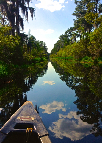
This ancient peat bog, is 404,154 acres (1635Km2).
Native Americans called the swamp "Okefenokee" or "trembling earth." This is because when people stepped over small islands, formed over the peat, they trembled. Source: Charlton County
Okefenokee Swamp habitats include open wet "prairies", cypress forests, scrub-shrub vegetation, upland islands, and open lakes.
Some of the wildlife species include, ducks, alligators, wading birds, amphibians, bobcats, raptors, white-tailed deer, and black bears. Source: State Parks
Today the Swamp is an example of ecologically intact ecosystem. This is the largest national wildlife refuge in the eastern United States.
Okefenokee is one of 599 Natural Landmarks across the U.S. It plays a valuable role in representing the biodiversity of the country.
Want to find more waterfalls? Look at this map of Waterfalls in the U.S.
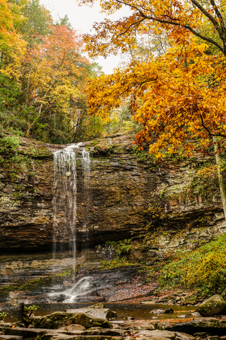
Amicalola Falls State Park
The Falls are located 70 miles (112Km) north of Atlanta. This park is managed by the State Dept. of Natural Resources and is represented with a lime green color on the map.
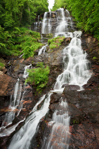
Amicalola Falls State Park is surrounded by the Chattahoochee National Forest, on the Appalachian Mountains. As an added bonus the Southern terminus of the Apalachian trail is located inside the park.
Amicalola Falls State Park has 829 acres (3.3Km2)of beautiful mountain landscape to explore.
Amicalola is a Cherokee word that means "tumbling waters". An appropriate name for waterfalls that are 729 feet (222m) tall. This is the third highest waterfall east of the Mississippi River.
The park is not just recognized by the falls, but by the beautiful trails inside the park. These have different lengths and difficulty levels, so visitors can hike according to their skill.
The park has a lodge, cottages, camping, and a restaurant available for visitors.
While visiting, remember that this area is home to different wildlife including black bears. Before visiting read the guidelines about how to deal and avoid an encounter with these creatures. Source: Amicalola Falls
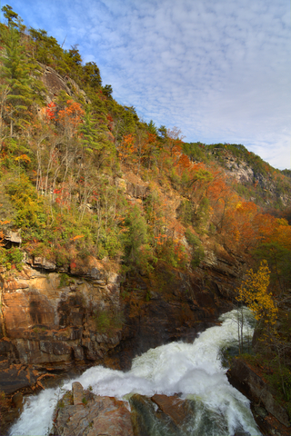
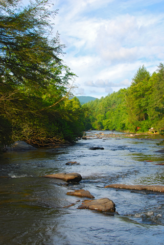
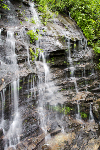
Tallulah Gorge State Park
Tallulah Gorge is located 99 miles (159Km) northeast of Atlanta. This Gorge is managed by the State Dept. of Natural Resources and has a lime green color on this map.
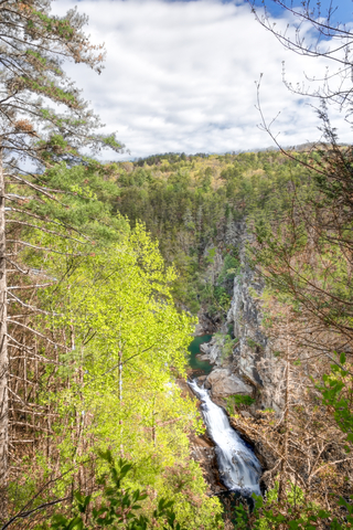
Tallulah Gorge is one of the most spectacular canyons in the eastern U.S. The gorge is 2 miles (3.2Km) long and 1,000 feet (304m) deep.
It is possible to walk to the gorge floor but this requires a permit and given to only 100 visitors per day. When there are water releases nobody can walk to the gorge floor!
Otherwise, visitors can hike different trails with several overlooks of the gorge. If this is not enough for those seeking incredible views, the park also has a suspension bridge 80 feet (24m) above the bottom.
In case visitors don't want to hike the uneven trails, it is also possible to use a paved path.
Tallulah Gorge is 2,739 Acres, and has a 63 acre (0.25Km2) lake. Besides hiking and biking the park offers opportunities for archery, fishing, swimming and tennis. It also has playgrounds, camping, RV, and picnic sites.
The gorge is filled with beautiful vegetation, including three protected species: the persistent trillium, the monkey-face orchid, and the green salamander. Source: Tallulah Gorge
If you would like to see Georgia's geography in more detail, this National Geographic Atlas found on Amazon, is the ideal resouruce for any recreation activity: Georgia Recreation Atlas.
Want to visit more parks? Look at this map of Florida State Parks, National Parks and Public Areas
Warm Springs and F.D. Roosevelt State Park
Warm Springs is located 40 miles (64Km) northeast of Columbus GA.
Warm Springs was made famous by F.D. Roosevelt as he visited the town frequently during his four president terms, and bathe in the mineral waters, as therapeutic treatment for his legs.
Unfortunately the mineral waters are no longer open for bathing. Nevertheless, visitors can go to the Warm Springs historic district, the Little White House, the museum and visit the pools. Source: Warm Springs.
Not far from Warm Springs is F.D. Roosevelt State Park, colored in lime green on this map. This park is easy to locate, as it has 9,049 acres (36.62 km2), making it Georgia's largest state park.
F.D. Roosevelt State Park is considered one of Georgia's best state parks. This is because it offers more tan 40 miles of trails. The most popular trail is the Pine Mountain Trail. This trail is cherished since it is surrounded by pines, it crosses creeks, and waterfalls.
Another surprising attraction of the park are its rolling hills. Many visitors don't expect to find them in south Georgia.
Fact: The park's Liberty Bell pool and the cottages were built during the Great Depression by the Civilian Conservation Corps. Source: FDR State Park
For more destinations and activities in Georgia, this book available on Amazon is for you, Georgia Discovered: Exploring the Best of the Peach State.
Providence Canyon State Park
Providence Canyon State Park is located 47 miles (75Km) south of the city of Columbus, GA, and is depicted in lime green on this map.
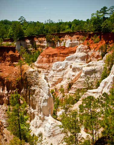
Known as Georgia’s ‘Little Grand Canyon’, it is characterized by towering pinnacles of colorful sandstone. The massive gullies are as deep as 150 feet (45m).
The colors vary from yellow, orange, pink, and purple. This is thanks to ground components and years of erosion. To this day sand flows downstream creating rock formations and the towering pinnacles. But most impressive is the presence of vegetation on top of the pinnacles, mounds, and crevasses left on the landscape.
One of the highlights of the park is the Plumleaf Azalea. This azalea only grows in this area and blooms in July and August. Source: GA State Parks
Unfortunately this formations are the consequence of poor farming practices during the 1800s, resulting in the erosion of the Coastal Plain.
The park has 1,003 acres (4Km2) and has over 10 miles (16Km) of hiking trails.
To preserve the parks fragile geology it is important to not climb the walls and stay within the marked trails. Source: Providence Canyon
Many of these areas are National Forests. To learn more about them go to this map.
Radium Springs Gardens
Radium Springs is just outside the city of Albany, GA. It is depicted in purple as it is managed by the Dougherty County.
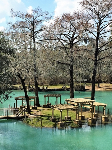
Radium Springs Gardens pumps 70,000 gallons of crystal clear, 68°F (20°C) degree water per minute from an underground spring.
Besides the spring waters, the sites main attraction are the local vegetation and the well kept gardens.
Today, you can walk around the restored courtyard that once held the Radium Springs Casino. Source: Radium Springs
Since the state has more than the Seven Natural Wonders of Georgia, here are more noteworthy parks that you cannot miss.
Cloudland Canyon State Park, Rising Fawn
Located in the North West corner of the state, it is the lime green colored polygon North East of Dalton. This park occupies 3,538 acres (14Km2).
Because of Georgia's topography, Cloudland Canyon has an amazing landscape with deep canyons, waterfalls, sandstone cliffs, caves, creeks, dense woodlands, and abundant wildlife. This park is blessed with breathtaking views wherever you go.
With impressive features abound, hiking and biking trails have multiple opportunities to awe visitors.
The park also has opportunities for climbing, caving, fishing, horseback riding, and camping. Source: Cloudland Canyon
Black Rock Mountain State Park, Mountain City
Located in the North East corner of the state, it is the lime green colored speck inside the large yellow polygon that represents the Chattahooche National Forest.
Black Rock Mountain is Georgia's highest state park, situated on the Blue Ridge Mountains.
From the mountains you can have 80 mile vistas. Enjoy hikes with over streams, past waterfalls and see plenty of trees and wildflowers.
Besides the forest and mountains it is possible to enjoy cottages, playgrounds and a small lake, popular with anglers.
Some of these parks are tightly related with the sea. To learn more about North America's Marine Ecoregions, check this map.
Cumberland Island National Seashore
Located south of Savannah, this park is in Cumberland Island, Georgia's largest barrier island.
The Island's only access is by water, nevertheless 41,000 tourists every year travel by boat to enjoy its beauty.
Visitors enjoy pristine forests, beaches, dunes, marshes and freshwater lakes.
The island also features historical sites. Source: Georgia National Parks
Chattahoochee-Oconee National Forests
This summary of best parks in Georgia could not finish without mentioning the elephant in the room.... state. The large yellow patch north of the state is Chattahoochee-Oconee National Forest, with 867,000 acres (3,508Km2) across 26 counties.
Chattahoochee-Oconee National Forest has thousands of streams and creeks, and 850 miles of trails. The forest also provides campgrounds, picnic areas, and other recreational activities.
Currently one of its prime objectives, is to preserve the natural Ginseng (Panax quinquefolius), a native plant of Georgia. The roots of this plant are highly priced in Asian countries, primarily China, for alleged medicinal qualities.
Because the plant has been over harvested, the population in the forests is very low to be sustainably harvested. It is under danger of disappearing if not protected. Source: Chattahoochee National Forest.
Want to learn more about Public Lands and parks? Click here for more information.
Sources for Georgia Parks Map
The shapefiles with state parks, forests, national parks, and wildlife polygons were downloaded from ScienceBase.
The shapefiles with Georgia's state boundary lines and cities were downloaded from Natural Earth Data.
Follow Me
This map will be updated with new data! To receive updates on this and more nature maps join my email list!!!!!!!
Made by Luz K. Molina with D3.js.