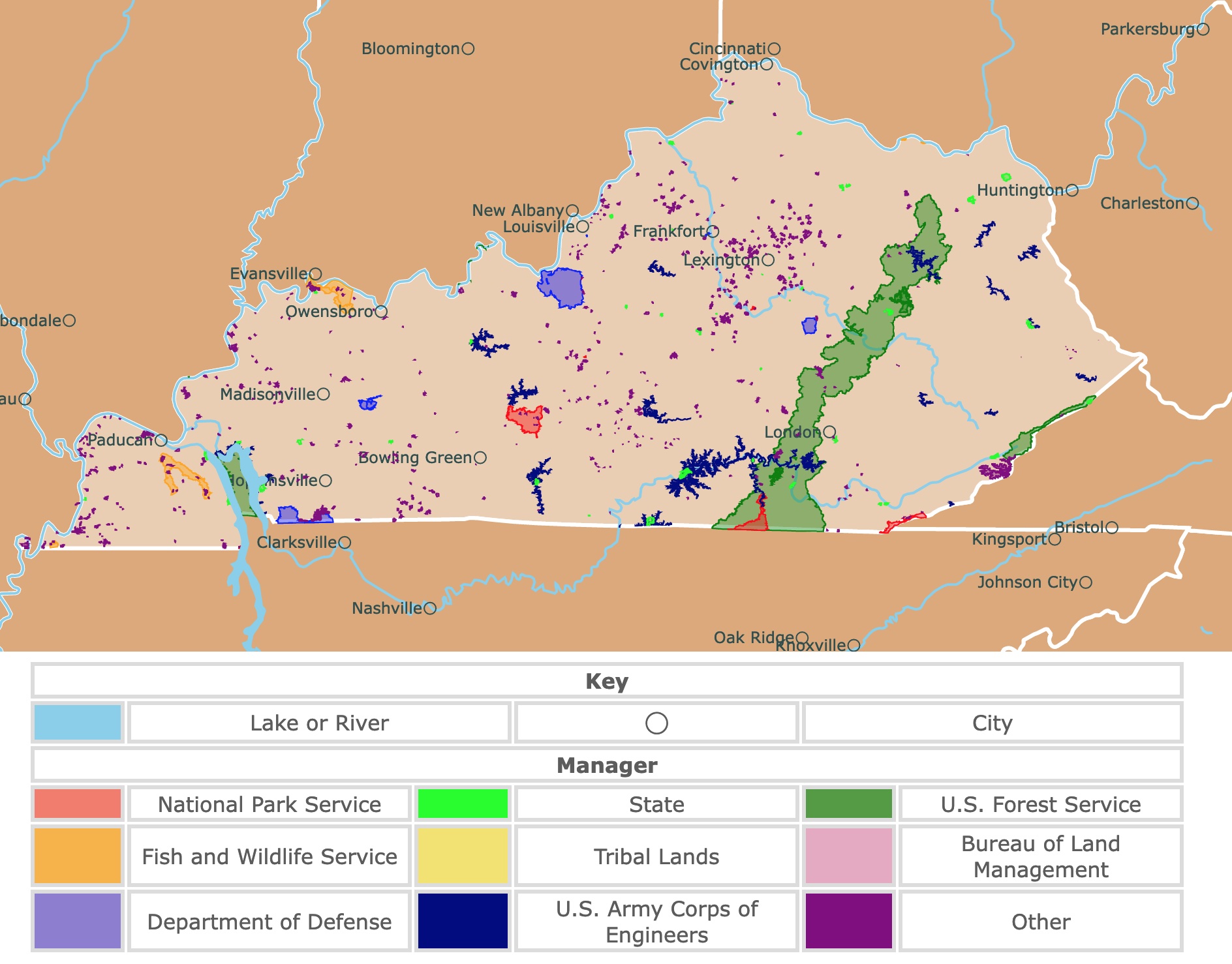
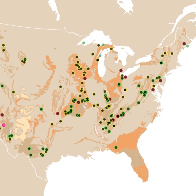
Map of Kentucky's Parks and Protected Areas
This interactive map shows the Locations, Names, Areas, and Details of National Parks, State Parks, National Forests, Tribal, and other Public Lands of Kentucky. It also shows major cities and rivers for context. For more detail, zoom in. For more information, hover over the map, or scroll down.
| Key | |||||
|---|---|---|---|---|---|
| Lake or River | ◯ | City | |||
| Manager | |||||
| National Park Service | State | U.S. Forest Service | |||
| Fish and Wildlife Service | Tribal Lands | Bureau of Land Management | |||
| Department of Defense | U.S. Army Corps of Engineers | Other | |||
Kentucky State Geography
Geography of Kentucky
Kentucky is bordered by Ohio and Indiana to the north, West Virginia and Virginia to the east, Tennessee to the south, and Illinois and Missouri to the west.
The state of Kentucky consists of six different geographical regions:
- To the far east is the Mountain Region, part of the Appalachian Mountian chain. This area has forests, narrow valleys, high ridges, and the state's highest point, Big Black Mountain, at 4,145 feet (1,263 meters) above sea level.
- The western part of the state is the Knobs Region. Here, erosion has formed hundreds of knob-shaped hills (monadnocks).
- Surrounded by the Knobs is the Bluegrass region, named for its bluish-green grass. The hills, sinkholes, springs, and caves result from weathered limestone.
- The Pennyroyal or Pennyrile Region is named after a species of mint that grows in the area. This region spreads west, crossing the center of Kentucky. The site is rocky, full of trees, lakes, and several caves, one of which is Mammoth Cave.
- Centered in Pennyrile is the Western Coalfield Region, a hilly area overlying over 4-thousand square miles of coal. John James Audobon State Park is in this region.
- Lastly, in the far western part of Kentucky lies the Jackson Purchase, a lowland full of swamps, ponds, and lakes; National Geographic.
Want to find places to explore in nearby Tennessee? Check this map of Tennessee Parks
Kentucky's Wildlife
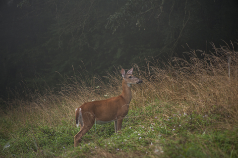
Some of the common mammals that call Kentucky home are black bears, elk, red foxes, minks, bobcats, and the most adorable river otters.
Looking to the sky, you'll see bald eagles, northern cardinals, mountain bluebirds, peregrine falcons, and the Kentucky warbler.
The eastern corn snake, six-lined racerunner, and broadhead snake are some of the common reptiles.
Amphibians such as the Jefferson salamander and the Kentucky spring salamander can hang around the water.
Kentucky's state tree, the tulip poplar, is native to the eastern U.S., along with the Kentucky coffeetree. Red maple, northern red oak, sassafras, and bald cypress stand tall throughout the state.
There are also Columbine, dwarf iris, purple coneflower, and the endangered Kentucky lady's slipper (a type of orchid). Some of the colorful wildflowers are native to the state.
Kentucky's Climate
The state of Kentucky experiences four distinct seasons. The northern portion of the state is about 5 degrees cooler than the west and south.
Summers are wet, hot, and humid. During July, the peak of summer, the average high temperatures cross the 95°F (35°C) mark, making the heat oppressive.
The Kentucky winters are cold and slightly bitter in January, with nighttime temperatures dropping below 23°F (-5°C). However, the temperatures rarely drop below 0 degrees.
Spring in Kentucky is mild, but storms and rapid weather changes can be expected. Autumn is typically primarily sunny with low humidity and quite pleasant temperatures.
The best time to visit Kentucky is autumn and spring. Winter is too cold, and summers are too hot.
Fall in Kentucky is the driest season, the landscape is beautiful, and storm activity is generally low. Spring offers mild temperatures and blooming flowers, Best Time.
Kentucky has lots of caves. To find more, visit this map of U.S. caves
Kentucky Parks and Forests You Cannot Miss
Mammoth Cave National Park
Mammoth Cave National Park is situated northeast of Bowling Green and is represented in red.
Mammoth Cave National Park holds thousands of years of human history and rich animal and plant life diversity. Therefore, the park has earned the UNESCO World Heritage Site and International Biosphere Reserve title.
The most popular part of the park is Mammoth Cave, the world's longest cave system. According to National Park Service, the official length of the cave is 420 miles. More miles could be added to that total when more mapping is complete.
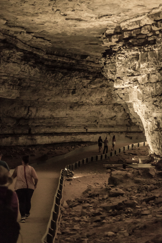
The cave has different tours, so it is better to check which one is more appropriate or interesting depending on what you are looking for.
Outdoor temperatures vary with the seasons, but the cave's internal temperature is 54°F (12°C) year-round!
The spring season is the ultimate time to visit the cave as there are more tour options and more frequent departure times. Mammoth Cave is a hot spot, so it's best to book tour tickets in advance.
The rolling hills and deep river valleys are inviting. The park has opportunities for fishing, kayaking, canoeing, and boating on 30 miles of waterways.
There are over 80 miles of hiking trails and 9 miles of biking trails also used by horses.
Thanks to its size and location, Mammoth Cave N.P. is perfect for stargazing. The park has dark skies where visitors can enjoy the stars without much light pollution.
The park has three front-country campgrounds. They're seasonal sites that close for the winter and reopen in March. Reservations can be made up to six months ahead of time.
Visitors can enjoy backcountry camping which can also be reserved. However, riverside camping is on a first-come, first-serve basis due to the river's fluctuating levels.
The Mammoth Cave Visitor Center is the best place to start your park experience, with exhibits and information about the park, Mammoth Cave.
Cumberland Gap National Historical Park
Cumberland Gap National Historical Park is the red strip in southeastern Kentucky.
It's been said that the Cumberland Gap is the first gateway to the west. Modern-day travelers marvel at the "great gateway" and the endless activities at the park.
The Cumberland Gap was a pass through the Cumberland Mountains, near the intersection with Tennessee and Virginia.
It is historically significant as it was a path for frontiersmen led by Daniel Boone and other pioneers to reach western Kentucky and Tennessee.
The park features cascading waterfalls, lush forests, and stunning vistas that ensnare the senses and provide visitors the opportunity for outdoor recreation in a beautiful setting.
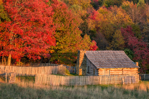
Pastoral landscapes and hand-hewn cabins can be explored at the park's historic Hensley Settlement. Park Rangers will guide you back into the 1900s when the settlement was established. This tour takes a few hours, so be sure to have some time on your hands.
A guided tour through Gap Cave allows visitors to explore miles of underground passages.
The 1.5-mile tour will enable visitors to explore four cave levels and includes a one-mile hike along the historic Wilderness Road. Make sure you have your hiking boots to explore this beautiful underground cathedral, Cumberland>.

Interested in forests? Visit this map of World Broadleaf Mixed Forests
Big Bone Lick State Park
Big Bone Lick State Park is situated southwest of Cincinnati.
Visitors can visit the local bison herd, tour the diorama pit and museum, explore the Salt Springs along the Big Bone Creek Trail, camp overnight, and snag some cool souvenirs.
The exhibits' displays are incredible, including presentations on paleontology, Ice Age mammals, Native American history, Ordovician geology, and the science chronology at Big Bone. There is ongoing research underway at the park, so something new might be added from one visit to the next.
Big Bone Lick is open year-round, but it closes at dark.
Wildlife watching is a popular activity at Big Bone. Bison can be seen every day of the year.
Middle to late spring is prime time for birding; this is the time of year that the Ruby-throated hummingbird and a colorful array of warblers can be spotted.
Orienteering is another popular park activity. This is a woods navigation sport where participants use maps and a compass or GPS to navigate an established course.
Big Bone currently offers two permanent woodland courses for orienteering.
The park has a spacious campground with campsites containing utility hookups, a playground, a swimming pool, and grills.
Restrooms, showers, and laundry facilities are available at the central service building. An on-site campground grocery store is also available for campers' convenience, Big Bone.
Daniel Boone National Forest
Daniel Boone Forest is the wide green belt in southeastern Kentucky and spans 21 counties in eastern Kentucky.
This forest consists of over 700-thousand acres of national forest system lands.
With over 600 miles of trails leading to two federally recognized wilderness areas, this park provides endless opportunities to explore Kentucky's incredible landscape.
Visitors can enjoy a plethora of outdoor recreational activities. Camping, birdwatching, climbing, hiking, and biking are only a handful of possible adventures.
The forest has plenty of lakes, streams, and rivers for aquatic recreation, including swimming, boating, kayaking, tubing, skiing, and even scuba diving.
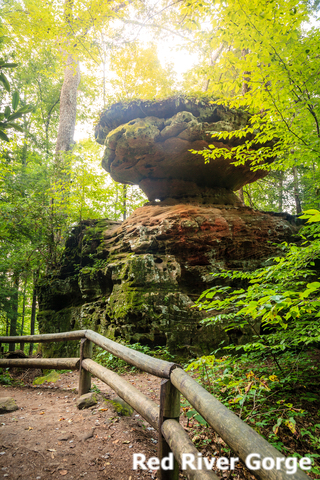
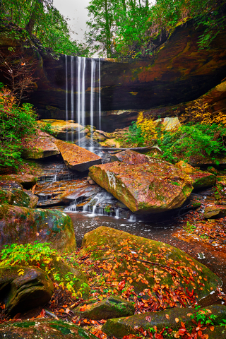
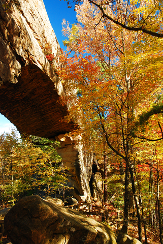
Inside the park is a green unit labeled "the Red". This is the Red River Gorge. An amazing geologic feature made of rock formations and cliffs. This is the most extensive collection of sandstone arches east of the Rockies!
This site is one of the best rappelling and climbing destinations in the world! Red River Gorge
For those who want to spend the night, there are cabin rentals, RV glamping, and camping locations. Daniel Boone Forest.
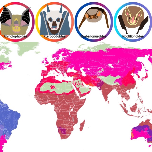
With so many caves, Kentucky is also home to bats. To learn more, visit this map of Bats' geographic range
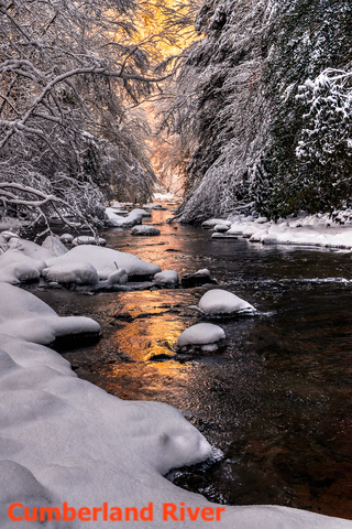
Cumberland Falls State Park
Cumberland Falls State Park is the small lime green area on the southern side of Daniel Boone Forest.
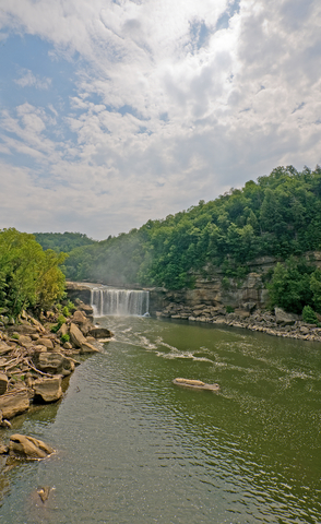
At Cumberland Falls Park, visitors can get an incredible view of the impressive Cumberland Falls, visit the Pinnacle Knob 1937 Fire Tower, or hike Eagle Falls Trail.
A unique feature of the park is its moonbows. These rare events occur regularly in the park. They are the result of moonlight being refracted by water droplets. The result is a white rainbow!
The falls also attract visitors for birdwatching. Specially warblers, as the park is a stop during their migration south.
The park has over 17 miles of trails for hiking or the opportunity of horseback riding through the forest. Visitors can also go fishing or enjoy gem mining with their families.
The park features 50 campsites with water hookups and electricity, Cumberland Falls.
Natural Bridge Resort State Park
Natural Bridge is the lime green area on the northern side of Daniel Boone Forest.
The park has a 2,200-acre forest, 22 miles (35Km) of trails, and a 60-acre lake.
Natural Bridge is one of the most popular parks in Kentucky. This is thanks to its incredible views of the forest and geological formations.
The park is also part of the Red River Gorge Geologic Area and displays a sandstone arch more than 75 feet (22.8) long and 65 feet (19.8m) high, Kentucky Tourism.
Visitors at the Natural Bridge Resort State Park can enjoy hiking the scenic trail to Natural Bridge or riding the skylift.
The Historic Nature Center can teach visitors a thing or two about the area and its history.
Reserve a private cottage or a lodge room with an incredible view. Hemlock Lodge has 35 rooms, each with a private balcony, and they're pet-friendly.
If you prefer sleeping in the great outdoors, the park has two campgrounds; both primitive and improved sites are available, Natural Bridge.
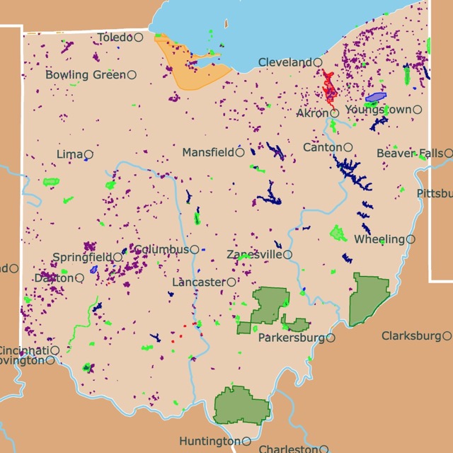
Want to find places to explore in nearby Ohio? Check this map of Ohio Parks
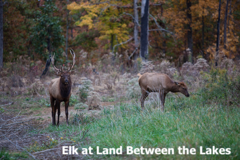
Land Between The Lakes National Recreation Area
This forest is situated in southwestern Kentucky. It is the green area between Lake Barkley and Kentucky Lake.
The Land Between The Lakes is comprised of over 17 thousand acres of forests, open lands, and wetlands.
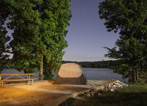
The area has 300 miles of undeveloped shoreline. Visitors have access to idyllic settings for outdoor activities such as camping, fishing, hiking, picnics, water sports, and wildlife observation.
Licensed hunters with the proper permits can hunt for squirrels, turkey, deer, and small game animals throughout the year.
Over 500 miles of trails are maintained for hiking, biking, horseback riding, and off-road riding. The park's horse camp is open year-round.
The scenic drive provides visitors with an optimum opportunity to view the wilderness from the comfort of their vehicle.
Four of the park's major educational attractions include the Elk and Bison Prairie, Homeplace 1850s Working Farm and Living History Museum, the Golden Pond Planetarium with an observatory, and Woodlands Nature Center, Land Between the Lakes.
Pennyrile Forest State Resort Park
Pennyrile Forest State Resort Park is the lime green area southwest of Madisonville.
Pennyrile has over 14,000 acres of forest and a 56-acre lake surrounded by a 2.6-mile loop hiking trail to admire and explore.
Visitors can come to hike the trails, including the Lake Trail, Indian Bluff trail, and Clifty Creek Trail.
Travelers go out to swim at the incredible sandy beach and explore the lake by kayak, canoe, pedal boat, or paddleboard.
Otherwise, grab your fishing pole, stroll across the Dam, and see what you can reel in. Don't forget your camera, you'll want to get some photos from Fisherman's Rock.
The stone lodge has 24 rooms overlooking Pennyrile Lake, near Dawson Springs. There are also cottages available; a handful of them are on the lake and include private docks!
The park's campground is open seasonally from March to the Middle of November. However, the equestrian campsites are available year-round.
Enjoy a game of basketball or tennis. Visitors can request a table at the restaurant by the birdfeeders to enjoy birdwatching while they dine. Lake Trail is another excellent place for birding.
Stop at the dock and rent pedal boats, canoes, kayaks, and rowboats. While motorboats are not permitted at Pennyrile Lake, Lake Beshear is only four miles from the lodge, and motorboats are allowed there. Don't forget your fishing poles, as the opportunities are endless.
Get incredible ariel video and pictures of these incredible parks with a drone, Pennyrile.
Affiliate Disclosure
Databayou.com is a participant in the Amazon Services LLC Associates Program, an affiliate advertising program designed to provide a means for sites to earn advertising fees by advertising and linking to Amazon.com. Databayou.com also participates in affiliate programs with Clickbank, CJ, and other sites.
If you plan to visit one of these beautiful parks or hike up the mountains, I suggest you get some of these items found on Amazon.
- Camping Cot: This comfortable cot with an air mattress is easy to fold, light, and comes with a battery-operated pump. Because you can camp and get a restful sleep.
- Portable Camping Table: Perfect for camping or beach days. This foldable light table comes with a storage bag and has a double layer for more capacity.
- Vevor Fire Pit Deflector: This stainless steel fire pit cover pushes the heat down and out. So when you are camping on chilly nights, you still get warm and cozy outdoors!
FOLLOW ME
Resources for Kentucky's Protected Areas Map
The shapefiles with Kentucky's state boundary lines, lakes, major rivers, and cities were downloaded from Natural Earth Data.
The Parks and Public Lands shapefiles for Kentucky were downloaded from USGS.
This map will be updated with new data! To receive updates on this and more nature maps, join my email list!!!!!!!
Made by Luz K. Molina with D3.js.