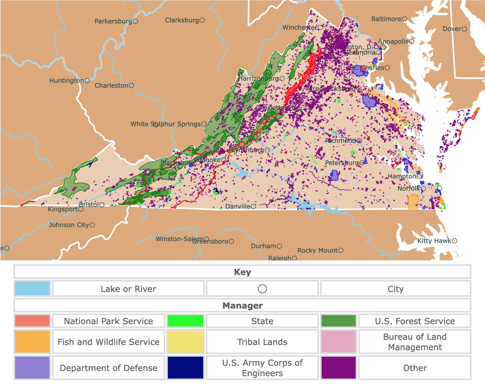
Map of Virginia's Parks and Protected Areas
This interactive map shows the Locations, Names, Areas, and Details of National Parks, State Parks, National Forests, Tribal, and other Public Lands of Virginia. It also shows major cities and rivers for context. For more detail, zoom in. For more information, hover over the map, or scroll down.
| Key | |||||
|---|---|---|---|---|---|
| Lake or River | ◯ | City | |||
| Manager | |||||
| National Park Service | State | U.S. Forest Service | |||
| Fish and Wildlife Service | Tribal Lands | Bureau of Land Management | |||
| Department of Defense | U.S. Army Corps of Engineers | Other | |||
Geography of Virginia
Virginia is a southern state that shares borders with Maryland to the north, West Virginia and Kentucky to the west, Tennessee and North Carolina to the south, and the Atlantic Ocean to the east.
Virginia can be divided into five geographical regions: the Atlantic Coastal Plain, the Blue Ridge, the Appalachian Plateau, Piedmont, and the Appalachian Ridge and Valley Region.
Atlantic Coastal Plain
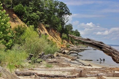
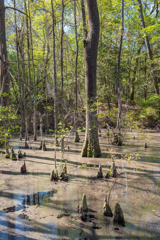
This region runs from north to south along the Atlantic Ocean. The Atlantic Coastal Plain is a lowland area. It stretches around 100 miles inland, and it's covered with swamps and salt marshes.
Piedmont
West of the Atlantic Coastal Plain lies Piedmont, the state's largest geographical land region. The area slopes gradually upward from 200 to 300 feet (60.96 to 91.44 meters) above sea level in the east to 900 feet (274 meters) in height to the west.
The rolling plains of the Virginia Piedmonts cover a majority of central Virginia, expanding 40 miles wide and 140 miles wide at North Carolina's border.
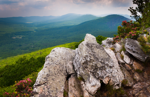
Blue Ridge
West of Piedmont is the Blue Ridge. The Blue Ridge rises from Piedmont in the east and the Appalachian Ridge and Valley Region to the west.
The Blue Ridge is the main eastern mountain range of the Appalachian Mountains. The ridge expands into a plateau with deep ravines, valleys, and the highest peak in Virginia, Mount Rogers, 5,730 feet (1,746 meters) above sea level.

If you want to learn more about the Atlantic Coast, visit North America's Marine Ecoregions Map
Appalachian Plateau
Located in the far southwestern portion of the state is the Appalachian Plateau. The Plateau extends into Kentucky, where it becomes the Cumberland Plateau. This region of Virginia is covered with streams, rivers and forests.
Appalachian Ridge & Valley Region
Along Virginia's western border lies the Appalachian Ridge and Valley Region. It extends southwest to northeast. The Great Valley, also known as the Valley of Virginia, is against the Blue Ridge to the east.
The Great Valley is a series of valleys divided by mountains. Shenandoah Valley is the most well-known and most prominent of the valleys. This region is riddled with caverns that have been carved into the limestone. Source: viriginiaplaces.org/regions/physio.html
Virginia's Climate
The highest temperature on Virginia's record was 110 ℉ (43 ℃) in July of 1954. -30 ℉ (-34 ℃) is the lowest temperature the state has ever seen since 1985 at Mountain Lake.
The monthly average temperatures can range from a low of 26.2 ℉ (-3.22 ℃) to a high of 88.4 ℉ (31.33 ℃); When to visit.
Virginia's Wildlife
Appalachian cottontail rabbits, Virginia opossums, Virginia northern flying squirrels, and black bears are a few common mammals living in Virginia.
Peregrine falcons, bald eagles, and golden eagles can be spotted in Virginia's sky, forests, or cliffs. Nesting along the coast are piping plovers and sneaky seagulls.
The state is home to 28 species of frogs, including mountain chorus frogs, green tree frogs, and southern leopard frogs. Poisonous snakes like the northern copperhead may be slithering around while hiking in Virginia. Other reptiles include the northern scarlet snake and the eastern glass lizard.
Virginia's tree varieties include hickory, maple, oak, pine, and magnolia. The dwarf pawpaw tree can also be found in the state.
Native flowers like the wild columbine, wild geraniums, coneflowers, and purple milkweed blossom and bloom throughout the state; Nat Geo
Want to find places to explore in nearby North Carolina? Check this map of North Carolina Parks
Top Virginia Parks and Protected Areas
George Washington and Jefferson National Forests
George Washington National Forest is the green strip of land in western Virginia.
If you spend a bit of time in Virginia, you're likely to hear about George Washington National Forest and Jefferson National Forest. Each forest is named for one of the founders of the U.S.
Since 1995, the forests have been combined and are now managed as one unit within the national forest system.
The acreage of these combined national forests is an incredible 1,664,110 acres. This vast land stretches to the Appalachian Mountains by the border with Tennessee, West Virginia, and Kentucky.
There's something for most nature lovers with 23 federally designated wilderness areas within the mountainous terrain.
The forest has over two thousand miles of streams, more than 40 tree species, 60 animals, and 50 endangered plant species.
Outdoor recreation opportunities at this forest include hiking, biking, paddling, wildlife viewing, camping, scenic drives, fishing, etc.
The land offers around 200 recreational sites, including campgrounds and a picnic area. It is possible to hike or backpack over 2-thousand miles of trails lacing through the park. Biking is permitted on various tracks as well; GWJ Forests.
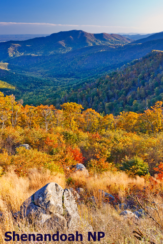
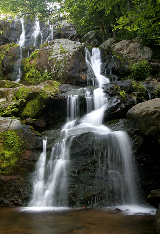
Shenandoah National Park
Shenandoah National Park and Wilderness is the red strip in western Virginia and is only 75 miles away from the hustle and bustle of Washington, DC.
This national park's land offers cascading waterfalls, stunning vistas, peaceful wooded hallows, and blooming fields of wildflowers.
Over 200-thousand acres of land and wilderness are protected in this park. The Shenandoah Wilderness is a paradise for songbirds, deer, black bears, and more.
The Skyline Drive is an incredibly scenic trip along the crest of the Blue Ridge Mountains. It's the only public road through the park. If inclement weather keeps you from driving in, boundary access points can be used to enter on foot.
Shenandoah has over 500 miles of hiking trails through the woods. The best part is that the park has tracks for different skill levels.
Old Rag Mountain is the most popular site and hikes in the park. It has scenic views and incredible rock formations. Regardless of the strenuous hike, the mountain is in such demand that the park has decided to require Old Rag Tickets for visitors.
The park has migratory birds and over 850 wildflower species that make the park a magnet for nature lovers.
Backcountry camping is available at the park. Different sites will vary in camping level and the skill level of the hiking trails around them.
Pets are welcome at Shenandoah National Park, including most hiking trails, campsites, and pet-friendly lodging. One requirement is that your pets must be on a leash no longer than 6-feet at all times; Shenandoah.

Virginia has beautiful Deciduous forests. To learn more, visit this map!
Richmond National Battlefield Park
Richmond National Battlefield Park comprises the red dots scattered in east Virginia. These are 13 separate subunits, each identified by their distinct brown signs and interpreted by historical markers from the National Park Service.
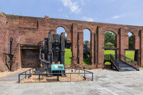
Between 1861 to 1865, this area was at the core of the war. This was the center of Confederate manufacturing. Armies battled on open fields, and here was one of the South's largest hospitals that cared for the wounded.
Battlefield Park is one of over 400 parks representing important examples of our country's natural history and cultural heritage.
Many of the sites at this park offer short self-guided trails taking you past historical areas or features, such as structures and earthworks. Some resources are incredibly fragile, park visitors must stay on the designated trails.
The Richmond National Battlefield Park has various programs and events for kids, ranger-led programs, trails for hiking and biking, and a museum to explore.
There are actually several different buildings with educational material about the structures, their purpose, and the events that took place in them; Richmond.
Prince William Forest Park
Prince William Forest Park is the red area northeast of Virginia.
The Prince William Forest Park is a respite full of quiet and peaceful tranquility.
In 1936 the Chopawamsic Recreation Area opened to house children's relief camps during the Great Depression. In 1948 the park was renamed, Prince William Forest Park.
The forest is fragrant, and the trickling streams have been inviting generations of visitors for years!
37 miles of hiking trails keep backpackers and hikers busy. 21 miles of bike-accessible roads and trails welcome bikers. There are four campgrounds to choose from and over 100 cabins at the park, making it easy to extend a much-needed recreational vacation.
Take the 9-mile hike along the South Fork Quantico Creek, ride your bike down an old fire road to explore the remains of Cabin Branch Pyrite Mine, and spend the night in one of the historic cabins.
Spend the day fishing at one of the lakes and observe the wildlife surrounding the area.
Even though part of the forest had fields and crops in the past, today, it is the perfect site to find over 900 plant species. These include the rare small-whorled pogonia, mosses, liverworts, white oak, yellow poplar, red maple, Virginia pine, mountain laurel, and wildflowers throughout the park.
The Prince William Forest Park hosted the International Orienteering Championship. This 60-point orienteering course was created in the 1970s, and it's one of the most extensive courses throughout northern Virginia. Maps and compasses are available free of charge at the park's visitor center, Prince William.
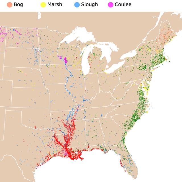
Virginia has lots of marshes. Interested in wetlands? Check this map!
Natural Tunnel State Park
Natural Tunnel State Park is the lime green park close to the state's southwest corner.
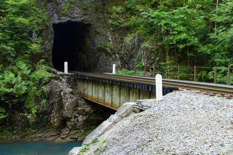
Natural Tunnel was naturally carved through a limestone ridge over thousands of years. It's over 850-feet long and 10 stories high.
The vast chasm between steep stone walls surrounded by several pinnacles (chimneys) is another one of the park's scenic features.
The tunnel is not very long, it has railroad tracks, and depending on the point of view, it is not possible to see the other side. Visitors can hike down a wooded trail to enter the tunnel.
Park guests can take a cave tour and canoe on the Clinch River. The Cove Ridge Center offers environmental education, overnight dorm accommodations, and conference facilities.
The park facilities include two campgrounds, cabins, picnic areas, a visitor center, a camp store, a gift shop, and a theater.
Visitors can also check out the Wilderness Road historic area. The swimming pool with a 100-foot slide is a popular area of the park. A chairlift to the tunnel floor is another sweet feature.
It is also possible to visit the Daniel Boone Wilderness Trail Interpretive Center, the museum, gift shop, conference room, and an outdoor classroom; Natural Tunnel.
Grayson Highlands State Park
Grayson Highlands State Park is the lime area on the southern border, east of Bristol. This state park is near Whitetop Mountain and Mount Rogers, two of Virginia's highest mountains.
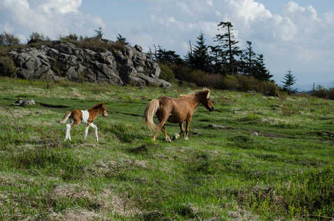
The high elevation in the mountains provides incredible views of the peaks, rhododendron forests, mountain meadows, and gushing streams.
Visitors must be aware that at these high altitudes, there are drastic drops in temperature and strong wind gusts.
113 hiking trails lead to overlooks and waterfalls and are open for skiing in the winter. One of these tracks has access to the Appalachian Trail! Nevertheless, you must be prepared, as a simple hike may quickly turn treacherous.
The boulders in the park provide ideal locations for climbing, while over 100 wild ponies make the park a sight to remember.
The park facilities include a visitor center and campgrounds. There are also scenic equestrian trails, horse camping areas, stables, and parking for trailers; Grayson.
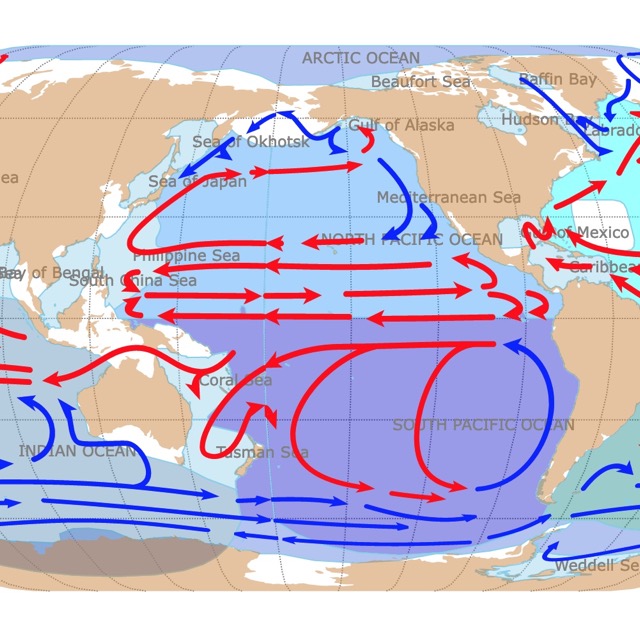
Virginia is greatly affected by the ocean and its currents. For more information, click on this map
York River State Park
York River State Park is northwest of Norfolk and is depicted in lime.
York River Park is known for its fragile and unique estuarine environment. This site is where saltwater and freshwater meet, creating a rich habitat for plant and marine life.
The park is on the York River, and it's designated as a Chesapeake Bay National Estuarine Research Reserve.
Besides the unaltered natural habitat, this park has fossil beds and Colonial and Native American artifacts.
Activities, programs, and the visitor center displays focus on the history, uses, wildlife, and preservation of the river and its marshes.
Over 30 miles (48 kilometers) of trails for hiking, biking, and horseback riding, allowing visitors to explore the river shoreline, forests, and the marsh.
Picnic areas with shelters and playgrounds are perfect for day trips or camping with the kids.
A boat ramp and a fishing pier give anglers access to freshwater and saltwater fishing locations. If you don't have your own gear, the park offers seasonal boat and recreational equipment rentals; York River.
First Landing State Park
First Landing is the lime area east of Norfolk.
First Landing State Park is rich with culture and history. This is where the English colonists first landed back in 1607. This was also a site for merchants, pirates, and military ships in 1812. Currently is listed on the National Register of Historic Places.
First Landing is one of Virginia's most visited parks. It's like a sanctuary nestled in urban Virginia Beach. There are 20 miles (32 kilometers) of trails for hiking and 1.5 miles (2.4 kilometers) of the beautiful Chesapeake Bay beach frontage.
First Landing is home to unique habitats thanks to varying topography, including dunes, lagoons, maritime forests, and bald cypress swamps. Naturalists and nature lovers can also find rare wildlife and plants.
A unique way to explore the park is using kayaks, canoes, or motorboats. There are boat ramps and seasonal boat renting, depending on the visitor's needs.
The park offers different options for visitors that wish to spend the night. There are cabin and yurt rentals, electric hook-up campsites, and tent campsites.
The park offers various recreational and educational activities throughout the year. There is a picnic area and a camp store in the park's vicinity; First Landing.
Want to find places to explore in nearby West Virginia? Check this map of West Virginia Parks
High Bridge Trail State Park
High Bridge Trail is the lime green strip west of Petersburg.
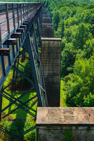
The park's main feature is the impressive High Bridge Trail, with over 2,400 feet (731 meters) in length and 125 feet (38 meters) over the Appomattox River.
This historic landmark is one of the longest recreational bridges in the state, and it's one of the longest in the U.S.
The trail is 31 miles (49.88 kilometers) and is ideal for hiking, biking, and horseback riding. It is possible to start at Farmville for a short and easy journey. From there, the bridge is only 4.5 miles away.
At one time, the trail was a rail bed; therefore, it is wide, level, and generally flat. Thanks to its dimensions, traveling in it is pretty enjoyable; High Bridge.
Kiptopeke State Park
Kiptopeke State Park is the lime speck northeast of Norfolk.
Kiptopeke is a coastal park that offers outdoor recreational access to the Chesapeake Bay. Besides the coastal beauty, this park offers nature lovers the opportunity to explore the unique migratory bird habitat along the Atlantic Flyway.
Spend the night, a weekend, or a week at the park with options of two and three-bedroom cabins, six-bedroom lodges for groups, RV and tent campsites, yurt and bunkhouse rentals.
The park has a boat ramp, a lighted fishing pier, picnic areas, and over 5 miles of trails for hiking and biking. A playground and the beach are the kids' favorite features. The bathhouse at the beach makes freshening up easy.
The park offers seasonal interpretive and educational programs focusing on birding, bay ecology, and natural history; Kiptopeke.
Affiliate Disclosure
Databayou.com is a participant in the Amazon Services LLC Associates Program, an affiliate advertising program designed to provide a means for sites to earn advertising fees by advertising and linking to Amazon.com. Databayou.com also participates in affiliate programs with Clickbank, CJ, and other sites.
If you plan to visit one of these parks or hike up the Blue Ridge, I suggest you get some of these items found on Amazon.
- Inflatable Kayak: This 2 person inflatable kayak is perfect for hauling in and out of any site. It is comfortable and has a backrest.
- FOVAL 200 Watt Car Converter: Plugs into your vehicle and can charge cell phones and other items.
- Bamboo Folding Table: Perfect for camping, tailgating, barbecues, or the beach. It is lightweight and portable.
FOLLOW ME
Resources for Virginia's Protected Areas Map
The shapefiles with Virginia's state boundary lines, lakes, major rivers, and cities were downloaded from Natural Earth Data.
The Parks and Public Lands shapefiles for Virginia were downloaded from USGS.
This map will be updated with new data! To receive updates on this and more nature maps, join my email list!!!!!!!
Made by Luz K. Molina with D3.js.