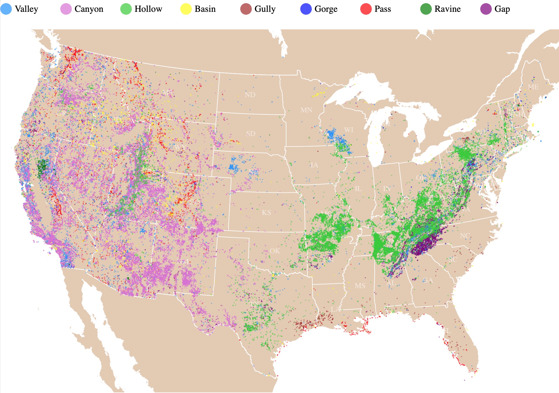
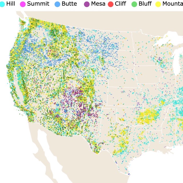
Valleys, Canyons, and Depressions: Where are they Found?
This is an interactive map of Valleys and depressions from the continental United States. It shows the locations of features named Valley, Canyon, Hollow, Basin, Gully, Gorge, Pass, Ravine, and Gap. For names and types, hover over the map. Zoom out to see Alaska and Hawaii. Zoom in to see all landforms in detail.
Valleys, Canyons, and Depressions Map
This map locates different forms of depressions found in the United States. The names were chosen as synonyms of the word valley and taken from GNIS.
Some are characteristic landforms of a particular region due to the geography and geology of the area.
Others are probably the result of local populations designating them but are not necessarily describing a particular geographic feature.
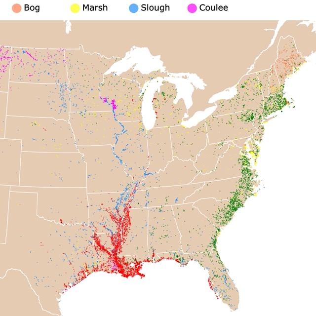
This map shows you where Swamps and Bayous are found throughout the US
Valleys
Valleys are the most common landform on Earth. They are found on every continent and even at the bottom of the ocean!
Valleys are extended depressions on the surface of the Earth. They are commonly enclosed by hills or mountains and are usually occupied by a river or stream.
Valleys usually have a slope that takes the river flow to another river, a lake, or the ocean.
Valleys are formed thanks to erosion or slow weathering of land by wind and water.
River valleys are created by water eroding rock and soil.
Valleys can be steep or broad. Their shape depends on the slope, rock, and bottom soil. The size depends on the length of time of the erosion.
There are three common types of valleys.
V-Shaped Valleys
V-Shaped valleys are narrow with steep slopes. They would look like a "V" from a cross-section of the valley. They may also be called River Valley.
V-shaped valleys result from the strong flow of streams that cut down the rock over time. The streams flow fast because the slopes are steep..
The river's force picks rocks and stones that grind and carve the river bed. This process is known as downcutting.
River valleys are commonly found at river sources because that is where the bank is steeper.
These valleys are formed in montainous areas, and the streams are young. They are commonly found in high altitudes.
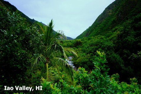
Examples of V-shaped valleys include Iao Valley in Hawaii (to see it on the map, you must zoom out and find it on Maui Island).
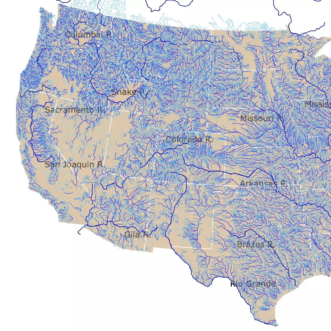
Rivers are closely related to valleys and canyons. To learn more, visit this map of U.S. Rivers and streams.
U-Shaped Valleys
U-shaped valleys have a cross-section that looks like a "U". They may also be called Glacial Valley.
These valleys have steep sides that curve close to the base. At the bottom, these valleys have a flat and broad bottom, giving them their distinctive "U" shape.
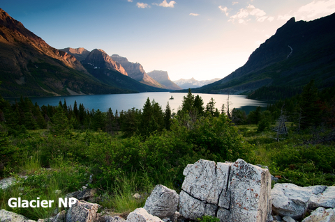
U-shaped valleys are the result of erosion from glaciers. As large glaciers slowly move down mountains, they carve these valleys. These valleys are found in areas of high elevation and high latitude.
These valleys were created during the last glaciation, 115,000 to 11,700 years ago, when glaciers covered a larger portion of the globe.
Because of their large size and weight, glaciers can completely change the topography of a landscape.
Alpine Glaciers form on top of mountains and are responsible for most U-shaped valleys. These glaciers moved down pre-existing V-shaped valleys eroding their sides.
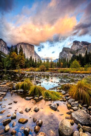
Examples include Yosemite Valley and Glacier National Park.
Hanging Valleys
Hanging Valleys are shallow valleys formed over a larger valley. They are called hanging because they hang over other valleys.
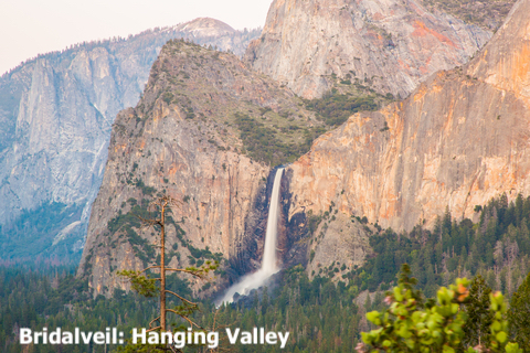
Hanging valleys are commonly formed as a result of glaciation.
They can be spotted thanks to their U-shape, and they are found at higher altitudes.
These valleys can form dramatic waterfalls. Source: Earth eclipse.
An example of this is Bridalveil Fall in Yosemite National Park.
Flat-Floored Valley
Flat-Floored valleys are the most common. These valleys are formed by mature streams.

As the stream ages, it stops eroding the valley walls and begins to deteriorate its own channel. The result is a meandering stream.
With time the stream meanders more of the valley floor and widens it further. When there are flood events, the excess material is deposited on the floodplain, building it up.
Flat-Floored Valleys begin as a V-shape or U-shape valley and slowly transform into a flat valley. They are typically found at lower elevations; ThougtCo.
Features are not only punctual. Some form beautiful contour lines worth exploring
Rift Valleys
Rift Valleys form where the Earth's crust is spreading or splitting.
These valleys are usually narrow, with steep sides and a flat floor. Many of the rift valleys are found underwater along ocean ridges.
Ocean Ridges and rift valleys are formed when tectonic plates pull apart. An example is the East African Rift Valley.
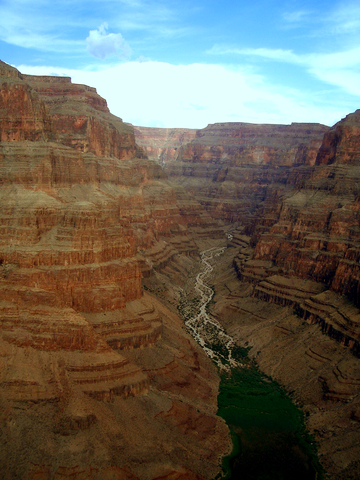
Canyon
Canyons are deep narrow valleys with steep walls. They are passages that cut through Earth's surface and have steep cliffs on both sides.
The flow of rivers, weathering, erosion, and tectonic activity result in canyons.
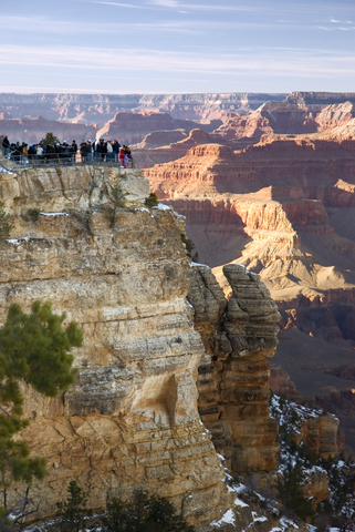
The word canyon comes from the Spanish word "cañon", which means pipe or tube; National Geographic.
Canyons are formed in mountainous areas that are frequently semiarid or arid regions. They occur where river erosion is greater than general weathering (combined action of all processes that cause the rock to disintegrate).
They range in size from a ditch to the Grand Canyon, which is more than 1 mile deep.
Canyons can be found anywhere in the world. They can even be found at the bottom of the sea.
Canyons are formed by the erosion of flowing water and can be widened by landslides. The formation of canyons can take millions of years.
Canyons can also be formed by weathering when water that seeps into cracks freezes in winter. As it freezes, it expands and makes bigger cracks that eventually form canyons.
Limestone is a type of rock that is often found in canyons.
Another way canyons are formed is through tectonic activity. When tectonic uplift occurs, rivers or glaciers cut through it, forming deep canyons.
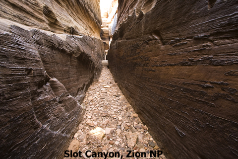
According to World Atlas, there are three common types of canyons:
- Box Canyon: Canyons that are shorter, narrower, and have 3 sides.
- Slot Canyon: These are narrow canyons with smooth walls.
- Submarine Canyons: These are the steep valleys on continental slopes under the sea.

This map shows you where Lakes and Ponds are found around the U.S.
Hollow
An elongated lowland between ranges of mountains or hills. Hollows have a stream or river running along the bottom.
They are also described as small valleys.
Basin
Basins are large-scale depressions on land or the seafloor. The sides may dip gently or steeply, but their bottoms are always wider than their depth.
Basins are commonly shaped like bowls, circular, or oval, and lakes are usually at the lower sides of basins. Some basins are filled with water, others are empty.
Some say valleys are very similar to basins. The difference is that valleys have an outlet and basins don't.
There are three major types of basins, river drainage basins, ocean basins, and structural basins; source: Geography name.
- A river drainage basin is an area drained by a river and all of its tributaries.
- The largest water-filled basins are ocean basins, the Pacific, Atlantic, and Indian ocean basins.
- Structural Basins are formed by tectonic activity, weathering, and erosion. These are the basins displayed on the map above.
Gully
Gullies are landforms created by surface runoff that erodes deep into the soil, especially on hillsides.
Gullies are basically wide ditches or valleys in their early stages. They are just a couple of feet deep and wide.
Gullies are formed by erosion and are common in areas lacking vegetation due to grazing or deforestation, World Atlas.
Gorge
A gorge is a narrow valley with steep walls between mountains or hills.
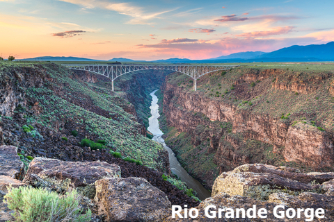
Gorges are used as synonyms for canyons, but gorges are more vertical, narrower, and smaller than canyons.
Erosion, geologic uplift, or both form gorges.
Governments flood gorges to create waterways and dams. These are used in turn to generate electricity. Source: National Geographic.
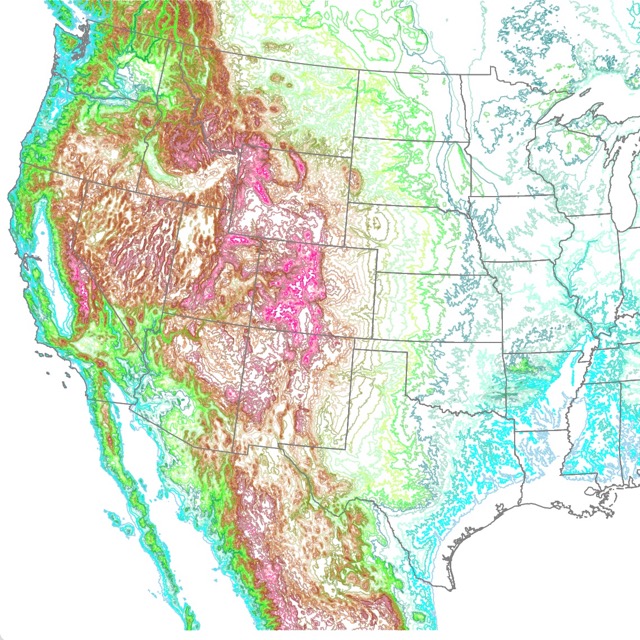
Valleys are determined by summits, hills, and mountains around them. Interested? Visit this map of mountains and Hills in the U.S.
Pass
Passes are routes through a mountain range. They are the highest portion of the path through a mountain range. It is the land between areas of high terrain.
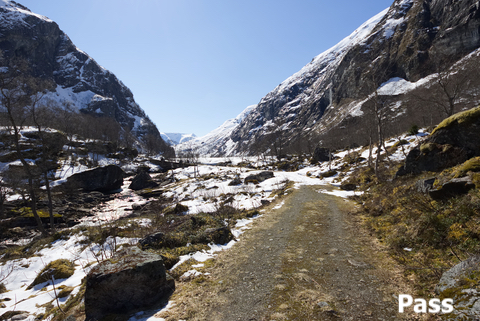
Passes are flat at the summit and have the shape of a saddle.
Mountain passes can be formed by 2 volcanic peaks, glacier activity, rain, or erosion from snowmelt.
Passes may also refer to a channel or deepest part of a body of water that permits passage. This is why they are found on the shores of the Gulf Coast on this map.
An example is Independence Pass, in the Rocky Mountains, Colorado.
Ravine
A ravine is a canyon or a valley with steep sides but smaller. Ravines are usually larger than gullies.
Ravines may have an active stream throughout the year or just seasonally.
Ravines are formed by the action of streams, and they are generally several hundred feet wide. Source: Worldlandforms.com
Gap
A Gap is the lower elevation between two landmasses with higher elevations, like mountains. Gaps are similar to passes but more rugged and hard to cross. Most rugged gaps are called notches.
Gap, Pass, Notch, and Saddle are different names that describe the same feature type.
Valley and Canyon Facts
- The tallest valley in the U.S. is San Luis Valley. It is located between the San Luis Hills in Colorado and the Taos Plateau in New Mexico.
- When valleys sink below sea level, they become sunken valleys. An example is the Syndey Harbour in Australia.
- Death Valley is the lowest valley on land. It is found in California, and it is 282ft (86m) below sea level.
- Famous valleys in the United States include Central Valley and Silicon Valley in California. The Hudson Valley in New York, the Rio Grande Valley in Texas, Las Vegas Valley in Nevada, Little Cottonwood Creek Valley in Utah.
- The largest valley in the world is Rift Valley. It runs along the Mid-Atlantic Ridge in the Atlantic Ocean.
- The deepest valley in the U.S.is Owens Valley in California, with summits over 12,000 feet (3,600m) and, on average, 4,000 feet (1,200m).
- The deepest canyon in the U.S.is located in Idaho, and Oregon. It is called Hells Canyon and it is 8,043 feet (2,452 meters) deep.
- The most famous canyon in the world and the largest canyon in the United States is the Grand Canyon, located in Arizona. The Grand Canyon is 277 miles (446 km) long, up to 18 miles (29 km) wide, and reaches a depth of over a mile (6,093 feet or 1,857 meters).
- This is up to discussion, but some may say that the prettiest valley in the United States is Yosemite Valley in California.
Affiliate Disclosure
Databayou.com is a participant in the Amazon Services LLC Associates Program, an affiliate advertising program designed to provide a means for sites to earn advertising fees by advertising and linking to Amazon.com. Databayou.com also participates in affiliate programs with Clickbank, CJ, and other sites.
If you love maps, you will find some of these items found on Amazon, perfect for your home.
- U.S. Topographic Wall Map: This wall map is laminated, with shaded relief, and is perfect for framing.
- 3D Wood World Map: This is a wall art decor for your home or office.
- Map with National Parks and Landmarks: This fun map has push pins to mark places you have visited and sites you might want to explore!
Follow Me
Resources for Map of Valleys and Canyons
The data was downloaded from the Geographic Names Information System (GNIS), maintained by USGS. Data cleaning was done with R Project for Statistical Computing. Only the points related to landforms were left.
The Shapefiles for this map were downloaded from Natural Earth. The code was obtained and altered from Chris Williams’s Block.
Made by Luz K. Molina with D3.js.
This map will be updated with improved and recent information! To receive updates on this and more nature maps, join my email list!!!!!!!