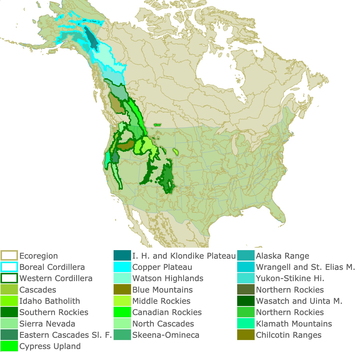
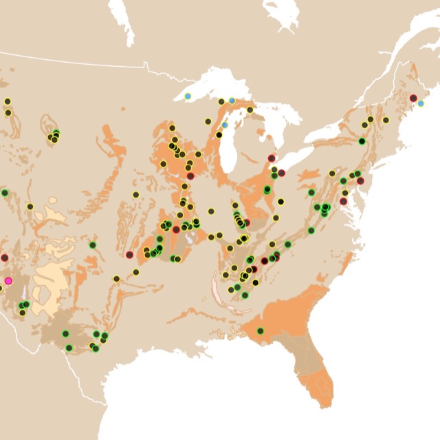
Map of America's Northwestern Forested Mountains
This interactive map shows America's Northwestern Forested Mountains, its divisions, and major natural parks, and preserves to visit. For more detail zoom in. For more data hover over the map. For more information scroll down.
| Ecoregion | I. H. and Klondike Plateau | Alaska Range | |||
| Boreal Cordillera | Copper Plateau | Wrangell and St. Elias M. | |||
| Western Cordillera | Watson Highlands | Yukon-Stikine Hi. | |||
| Cascades | Blue Mountains | Northern Rockies | |||
| Idaho Batholith | Middle Rockies | Wasatch and Uinta M. | |||
| Southern Rockies | Canadian Rockies | Northern Rockies | |||
| Sierra Nevada | North Cascades | Klamath Mountains | |||
| Eastern Cascades Sl. F. | Skeena-Omineca | Chilcotin Ranges | |||
| Cypress Upland |
America's Northwestern Forested Mountains
America's Northwestern Forested Mountains extend from Alaska through Yukon all the way to California and Nevada. This ecoregion has North America's highest mountains, and a great diversity of ecosystem types from tundra to grasslands.
The reason to combine all these areas in one single ecoregion is topographic. Chains of mountains cross its whole length. This is a major area for skiing, hiking, and different outdoor activities! CEC.org.
| Ecoregion Level II | Ecoregion Level III | Location |
| Boreal Cordillera | Interior Highlands and Klondike Plateau | Alaska and Yukon Territory |
| Alaska Range | Alaska | |
| Copper Plateau | Alaska | |
| Wrangell and St. Elias Mountains | Alaska and Yukon Territory | |
| Watson Highlands | Yukon Territory | |
| Yukon-Stikine Highlands/Boreal Mountains and Plateaus | British Columbia | |
| Western Cordillera | Cascades | British Columbia |
| Skeena-Omineca-Central Canadian Rocky Mountains | British Columbia | |
| Chilcotin Ranges and Fraser Plateau | British Columbia | |
| Northern Rockies | British Columbia | |
| Cypress Uplands | Alberta and Saskatchewan | |
| Canadian Rockies | Alberta | |
| North Cascades | Washington | |
| Blue Mountains | Oregon | |
| Idaho Batholith | Idaho | |
| Middle Rockies | Montana | |
| Wasatch and Uinta Mountains | Utah | |
| Southern Rockies | Colorado | |
| Sierra Nevada | California | |
| Klamath Mountains/California High North Coast Range | California, Oregon | |
| Eastern Cascades Slopes and Foothills | Washington, Oregon, and California |
The Chilcotin Ranges, Skeena-Omineca-Central Canadian Rocky Mountains, Watson Highlands, Cypress Uplands, Yukon-Stikine Highlands/Boreal Mountains and Plateaus are exclusively Canadian and are not described below as they are not part of the United States.
The description of each region includes some geology of the area, their natural attributes, and selection of parks and preserves for you to visit and enjoy.
BOREAL CORDILLERA
This is the most western subdivision and the most recently glaciated. This is visible in its U shaped valleys cutting through the mountains. Some areas scaped glaciation and have Karst topography with limestone and caves.
The region has short summers and cold winters, with topography creating regional microclimates. Permafrost is patched and in higher altitudes. Rainfall is lower in valleys and high on mountains.
Precipitation comes as snow and snowmelt at lower elevations which flows downstream.
At higher altitudes this region has forests, mostly consisting of conifers, fewer mixed forests, and only a few scattered areas where hardwoods are dominant.
Mining particularly for gold and some forestry are some of the main industries in this area
Interior Highlands Klondike Plateau
This region is mainly composed of rounded, low mountains of 3,937 feet, with rugged peaks. The terrain consists of steep, rounded ridges.
Highest elevations have no vegetation. Lower elevations have dwarf scrub vegetation and open spruce stands. The lowest areas are protected from the wind and have a denser vegetation cover. Ecoregions of Alaska.
Yukon Charley Rivers National Preserve Alaska
In this national park it is possible to paddle down the Yukon River to view Alaska's interior landscape. The river is full of sediment due to runoff in the summer, but in winter it is clear, as the glaciers are frozen. It is common to use canoes, kayaks, homemade wooden rafts, and inflatable rafts.
The Preserve is one of the rare areas in North America where so much of geologic history is preserved (Precambrian era to the Cenozoic). This is in part because the Tintina Fault crosses the park, giving it a access to wide array of rocks. Since most of the preserve was not glaciated, many of the geologic and palaeontologic records are not under glacial debris.
The park is home to rare subarctic steppe endemic plants and to Peregrine Falcons, as well as bears Yukon - Charley Rivers.
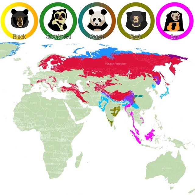
Lots of Wilderness specially bears. For a better view explore this MAP about bear habitat!
Alaska Range
The mountains of south central Alaska are very high an steep. The region is covered by rocky slopes, icefields, and glaciers. Much of the area has no vegetation.
The region has a continental climatic regime, but in high peaks the precipitation, and climate is similar to that in maritime areas.
Large active volcanoes occur in this area and mountains often rise over 12,795 feet (3,900m) including Denali, formerly known as Mt. McKinley, which reaches 20,310 feet (6,190m). Denali is the highest mountain peak of North America.
The area was heavily glaciated in the Pleistocene epoch and large areas of valley glaciers are visible. Rock glaciers are common too.
Slope gradients may be 2° to 25° in some mountains. Temperatures may be -13 Fahrenheit in Winter to 64 Fahrenheit in the Summer.
Most of this ecoregion has no vegetation or it has Dwarf scrub communities. Ecoregions of Alaska
Denali National Park
Denali is six million acres of wild land, crossed by one unpaved road. In this park it is possible to see the low elevation taiga forest to the high elevation tundra.
One of the parks greatest assets is North America's tallest peak, Denali. My personal experience was that the park is so big and the mountain so enormous it is hard to see it, You are on it! The omnipresent clouds may block the views of the mountain.
Fortunately once we drove away and there were no clouds, we saw a gigantic white dome. It was not like other snowy peaks I am used to seeing on pictures. It was massive and beautiful. It was Denali.
There are no hotels, only campgrounds. The park must be devoid of human development.
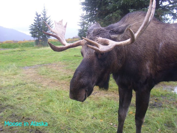
Besides the beautiful landscape it is the free roaming wildlife that attracts tourists every year. It includes Grizzly bears, black bears, moose, wolves, caribou, and Dall's sheep.
Smaller animals include foxes, marmots, red squirrels, golden eagles, bald eagles, and arctic ground squirrels.
Because of Bear encounters, it is suggested that visitors take a bear spray with them! Denali
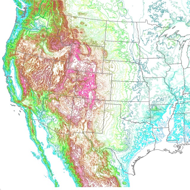
If you are interested in seeing the elevation of this area in more detail, you might like this map of US Topography.
Copper Plateau
This region was the site of a large glacial lake that existed during glacial times. The area has many lakes and wetlands.
Elevations go from 1377 feet to 2952 feet. Temperatures can reach -16 Fahrenheit in Winter to 69.8 Fahrenheit in the Summer.
Needleleaf forests and woodlands dominated by black spruce are the most common communities Ecoregions of Alaska.
Wrangell and St. Elias Mountains
These are steep and rugged mountains of volcanic origin. They are covered by ice and glaciers.
Dwarf scrub tundra communities, consisting of low shrubs, grasses, and lichens.
The area is characterized by shield volcanoes from the Cenozoic age. Mount Wrangell is still an active volcano.
Wrangell - St. Elias National Park
This is America's largest National Park with 13.2 million acres it is the same size as Yellowstone, Yosemite, and Switzerland combined!.
It is also remarkable in the fact that its elevation starts at sea level and reaches up to 18,008 ft.
The park is home to the boreal forest, which is one of the largest ecosystems in the world. It holds aspen, spruce and balsam.
Mount Wrangell is one of the largest volcanoes by volume in the world. This volcano is still active and has occasional steam plumes.
The area has a series of glaciers, peaks, thermal springs, mud volcanoes, diverse environments, historic copper mining, and geologic features Wrangell National Park.
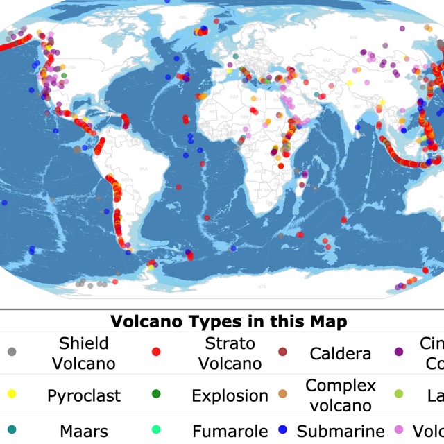
Some of these ecoregions and parks started as volcanoes. To find out more about them check this map.
WESTERN CORDILLERA
This mountainous region covers most of the Rocky Mountains. It extends from British Columbia to California and New Mexico.
Topography is steep reaching 14,440 feet (4400m) in Colorado
Precipitation occurs mainly on the West side of mountains due to the air masses from the Pacific. Snowfall and melting supplies the rivers with its water flow.
Climate is subarctic on top of the mountains to humid at mid elevations, to semi-arid at lower elevations.
The topography and dissimilar ecosystems leads to a lot of endemic species. Richest forest growth occurs at mid elevations bplant.org.
North Cascades
The North Cascades has high rugged mountains, and contains the greatest concentration of active alpine glaciers of the conterminous U.S., with a variety of climatic zones.
It is underlain by sedimentary and metamorphic rock US Ecoregions.
North Cascades National Park
This is an alpine landscape, with jagged peaks and more than 300 glaciers. It has cascading waters fed by the glaciers. Lakes are abundant, and about 400 miles of trails by mountains and forested valleys.
The park offers activities for hikers, backpackers, and climbers. The busiest season goes from April to October. Winters are wet and snowfall is heavy.
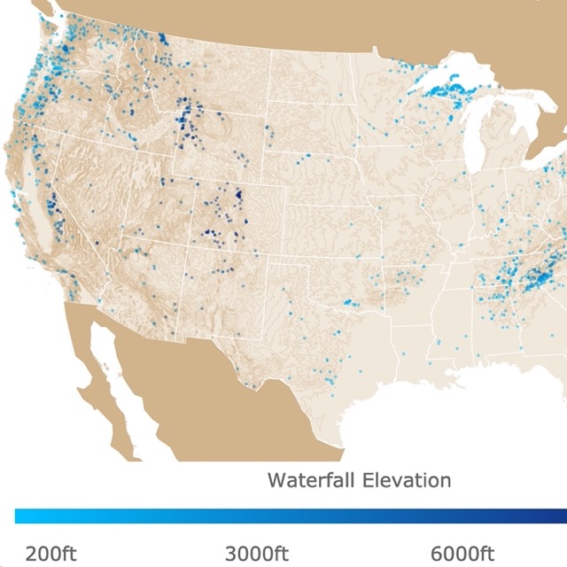
Want to know where to find more waterfalls? Check this map.
Cascades
This is a strip of land from Washington to California. It is characterized by volcanoes and alpine glaciation.
This ecoregion has a moist, temperate climate that supports a highly productive coniferous forest used for logging. At lower elevations Douglas-fir, hemlock, red cedar, and big leaf maple are common. US Ecoregions
Mount Rainier National Park
Located South East of Seattle, Mont Rainier at 14,410 feet (4,389m) above sea level, is a glaciated, active volcano.
Mount Rainier is surrounded by rivers, wildflower meadows, and ancient forests.
The park offers opportunities for hiking, and climbing. Nevertheless, the meadows are protected, and visitors are required to stay on the different trails offered.
During winter some roads are closed, others may be icy, and there is poor visibility. Because of the difficult conditions it is also more likely that wildlife will concentrate in certain areas like roads and parking lots. This sometimes results in dangerous encounters between wildlife and visitors.
Besides the obvious obstacles during winter, it is possible to enjoy of a winter wonderland while camping, snowshoeing, cross-country skiing and snowmobiling. Mount Rainier.
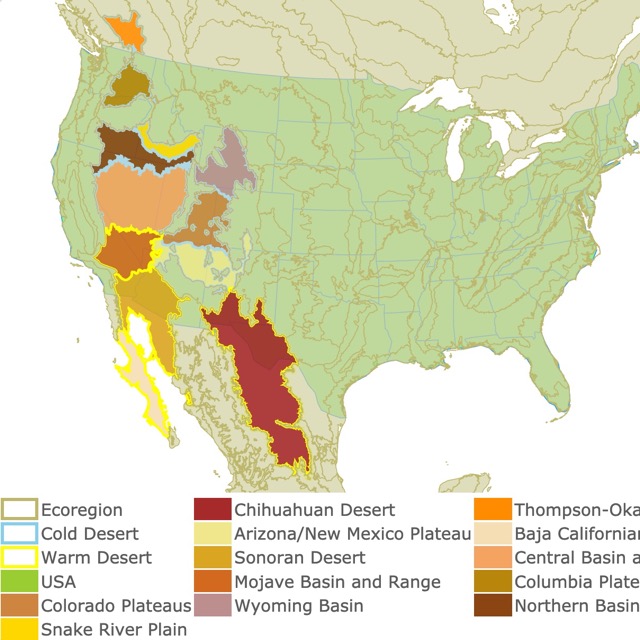
Keep reading about the mountains rain shadow? Here are the deserts formed by those shadows.
Eastern Cascades Slopes and Foothills
This is a rain shadow of the Cascade Range. Rain shadow means that it is the dry side of the mountains sheltered from the wind. It has more of a continental climate, than the west side, and greater temperature extremes.
This region has open forests of ponderosa pine, and lodgepole pine. These plants are adapted to a dry climate and frequent fires.
Volcanic cones and buttes are common in much of the region.
Lava Beds National Monument
Located in Northern California, monument is a rugged landscape thanks to the eruptions of Medicine Lake shield volcano.
The area is dotted with more than 800 caves, Native American art sites, and dessert wilderness.
The caves are the result of lava tubes. There is a cave loop to choose one of your like, with different levels of difficulty. Only one cave has lights, for the rest, visitors have to take flash lights and appropriate gear.
Not all caves are open. Some close to allow bats to hibernate. These may open at different times of the year.
This is one of the longest continually occupied areas in North America. There are plenty of archeological sites and rock art with pictographs and petroglyphs Lava Beds.
Want to learn more about caves or want to find one near your home? Check this map about them and their Geology.
Blue Mountains
These are low and open mountains of mainly volcanic origin. Much of this ecoregion is used for grazing cattle.
John Day Fossil Beds National Monument
This site has rock formations with a record of plant and animal evolution, changing climate, and past ecosystems that span 40 million years.
The monument allows for hikes, as long as you stay on the trails. It is possible to see Palisates a prominent volcanic landform, and you can also see fossils!
You may choose to hike to the painted hills area. As you walk you can see slopes with stripes of red, tan, orange, and black. There is also plant fossils and animal fossils.
The area offers opportunities for camping, biking, river rafting, and fishing. John Day
Northern Rockies
The Northern Rockies are a mountainous and rugged region. Climate and vegetation are marine influenced.
There are fir, spruce, pines, and western red cedar. There are also Alpine characteristics and glacial lakes at high altitudes.
Thick deposits of volcanic ash cover the region. Logging and mining are common in this area.
St. Joe River Area
The area has wild and scenic rivers plus extensive roadless and primitive areas.
There are miles of trails for hikers, horse riders, and mountain bikers.
This site is also recognized for its elk herds and blue-ribbon cutthroat trout.
If you are interested in seeing the elevation of this area in more detail, you might like this map of US Topography.
Canadian Rockies
Most of this region is located in Canada. It is higher and more ice-covered than the Northern Rockies, and it is more influenced by moist maritime air masses.
There are Douglas-fir spruce, subalpine fir and pine. Higher elevations have no vegetation. A large part is national parks where tourism is the major land use. Forestry and mining also occur in nonpark lands. US Ecoregions
Glacier National Park
The park has pristine forests, alpine meadows, rugged mountains, and spectacular lakes. The park has over 700 miles of trails, perfect for adventure and solitude.
The park has one of the most ecologically intact areas in temperate regions of the world. Due to wide variations in elevation, it has diverse plant and animal populations. The park is also a Biosphere Reserve and a World Heritage Site under the UNESCO, to preserve and protect the species diversity in the area.
Another perk of the park is that it is part of the international dark sky association. It requires its long term commitment to preserving night skies and nocturnal habitat for public enjoyment of the sky Glacier National Park.
Want to learn more of those peaks and mountains? To learn more, check this map that shows hills, mountains, and mounts.
Middle Rockies
Here, forests can have open canopies, and foothills are partly wooded. Intermontane valleys are grass or shrub covered and have a mosaic of terrestrial and aquatic fauna, different from the nearby mountains.
The area has recreation, logging, mining, and summer livestock grazing, as land uses.
Yellowstone National Park
Yellowstone is well renowned for hydrothermal features, including mud pots, geysers, fumaroles, and colorful hot springs of all shapes and sizes.
This park is a magnet for hikers. With 2.2 million acres and more than 900 miles of hiking trails.
Caution must be used as a large section of the park is above 7,000 feet, which results in snow being retained until late May. Some mountain passes may have snow until late July. Other trails may cross freezing rivers with strong currents.
The park has different areas where visitors are more likely to see different animals. All you have to do is pick your favorite one. Some of the animals you might encounter are: Grizzly bears, bison, black bears, elk, bighorn sheep, mule deer, pronghorn, and wolves. Suffice to say precautions must be taken and always follow the safety guidelines when dealing with wild encounters.
Other activities include taking photos, biking, riding horses, relaxing, camping, fishing, go on boat rides, and go for a swim. In winter it is possible to ski, walk on snowshoes, use snowmobiles, or use snow-coaches Yellowstone.
Grand Teton National Park
This park is memorable because of its landscape, which includes mountains, valleys, lakes, and rivers.
As other parks mentioned before there is hiking, and wildlife to photograph. Grand Teton's distinctive characteristic are climbing and mountaineering. Many climbers come hoping to reach its iconic peaks Grand Teton.
Interested in relaxing after a hike? Check this map hot springs in the US
Idaho Batholith
This is a partly glaciated mountainous plateau with perennial streams with undisturbed quality. The area has extensive intrusive weathered igneous rocks.
Grand fir, Douglas-fir, Engelmann spruce and subalpine fir grow in the area. Ponderosa pine, shrubs, and grasses grow in very deep canyons.
Nez Perce National Forest
This forest has 4 million acres of land. There is dry rugged canyons to moist cedar forests of the Selway, to rolling uplands of the Palouse Nez Perce.
Wasatch and Uinta Mountains
Characterized by mountains with narrow crests and valleys flanked in some areas by dissected plateaus and open high mountains. Some of the area is used for grazing livestock in the summer.
This mountains are flanked by desert and semiarid areas. Both known for their beauty and geologic formations.
Deer Creek State Park
This park is a reservoir. Perfect for windsurfing, boating, zip lines, swimming, and fishing Deer Creek State Park.

All those glaciers form more than valleys, and rivers. This map shows you where Lakes, Ponds, and Lagoons are located.
Southern Rockies
These are steep, rugged mountains with high elevations. Most of the region is covered by coniferous forests but like other western regions of the United States, it follows a pattern of elevational banding.
Low areas have grass and shrub that are heavily grazed. Middle elevations are covered with fir, aspen and juniper oak. They are also grazed. Higher elevations have coniferous forests with very little grazing activity.
The highest elevations have alpine characteristics, and of the 100 highest peaks in the Rocky Mountains, 78, including the 30 highest, are located in Colorado.
Rocky Mountain National Park
Rocky Mountain National Park is 415 square miles with beautiful mountain environments.
Rocky Mountains National Park has all kinds of winter activities like cross-country skiing, sledding, and snowshoeing.
The park also has closures to protect the rich wildlife diversity. Some of these include protecting elk, raptors, bald eagles, and big horn sheep. Nevertheless, there are many other species that can be admired during your hikes in the park Rocky Mountain National Park.
Klamath Mountains/California High North Coast Range
This region covers the Klamath and Siskiyou mountains. It also includes mixed conifer and montane hardwood forests.
The region’s mix of granitic, sedimentary, metamorphic, and extrusive rocks contrasts with the predominantly volcanic rocks of the Cascades.
The regions diverse flora, a mosaic of both northern Californian and Pacific Northwestern conifers and hardwoods, is rich in endemic species. The mild, subhumid climate is characterized by a lengthy summer drought.
Redwood National Park
Redwood is home to the world's tallest trees. They are the Coast redwood Sequoia sempervirens.
The park also has prairies, oak woodlands, riverways, and coastlands. The trees and the landscape are so beautiful that you can enjoy it just as a drive through.
The park offers plenty of trails to hike and bike and see the best of the redwoods Redwood.
Want to see more parks? Check this map of National Parks of North America
Sierra Nevada
In this region moraines, cirques and lakes are a result of alpine glaciation. In the Sierra is Mount Whitney with 14,500 feet. The tallest mountain in the conterminous United States.
The vegetation is mostly ponderosa pine and Douglas-fir at the lower elevations on the west side, pines, and Sierra juniper on the east side, to fir and other conifers at the higher elevations.
The Sierra Nevada casts a rain shadow over the desserts to the east.
Large areas are publicly-owned federal land, including several national parks.
Yosemite National Park
This valley is recognized for its granite, and tranquility. With its 1,200 square miles it is also known for its waterfalls, meadows, wilderness, and ancient giant sequoias.
Yosemite trails may be closed due to rock fall, snow, ice, or fire. Nevertheless, its famous valleys, are accessible by car year round. You might expect some traffic and congestion to this area in the peak summer months.
The list of landscapes and activities is endless. There are meadows, wetlands, museums, viewpoints, rock formations, and famous waterfalls. Yosemite
Sequoia & Kings Canyon National Park California
The rugged landscape with mountains, canyons, caverns, and the world's largest trees, the Sequoias.
In this park weather varies a lot by season and by elevation which varies from 1,300 feet to 14,400 feet.
The largest of the giant sequoias grow at the sometimes snowy mid-elevations, with diverse plants and animals around them.
The park offers skiing, snowshoeing, hiking, winter drives, and viewpoints. This park is ideal for families as it even has designated snow play areas Sequoias.
Affiliate Disclosure
Databayou.com is a participant in the Amazon Services LLC Associates Program, an affiliate advertising program designed to provide a means for sites to earn advertising fees by advertising and linking to Amazon.com. Databayou.com also participates in affiliate programs with Clickbank, CJ, and other sites.
Before you decide to make a trip to one of these incredible areas I suggest you check some of these products found on Amazon.
- Because many paths in this region have uneven terrain, I suggest you use these boots. They will provide comfort, while you reach your destination. Merrell Moab 2 Mid Waterproof Hiking Boot.
- In case you are planning to camp at the park keep in mind the temperatures drop drastically at night. I suggest you take this sleeping bag: Mountaintop Ultralight Mummy Sleeping Bags 650 Fill Power Duck Down Suits for 32 Degree F for Camping Hiking Backpacking.
- For a winter wonderland, you better be prepared and take the right items. I suggest this winter jacket Burton Womens Gore-Tex Kaylo Jacket. It is comfortable and warm.
- If you plan on going snowshoeing, I suggest you take a look at these snowshoes found on Amazon FLASHTEK Snowshoes for Men and Women, Light Weight Aluminum Terrain.
Northwestern Mountains Map Resources
This map displays North American Ecoregions Level III. At the same time it highlights the Northwestern Mountains of North America. The data comes from the U.S. Environemntal Protection Agency EPA. The shapefiles were downloaded from ArcGIS.
This map will be updated with improved and recent information! To receive updates on this and more nature maps join my email list!!!!!!!
Made by Luz K. Molina with D3.js.