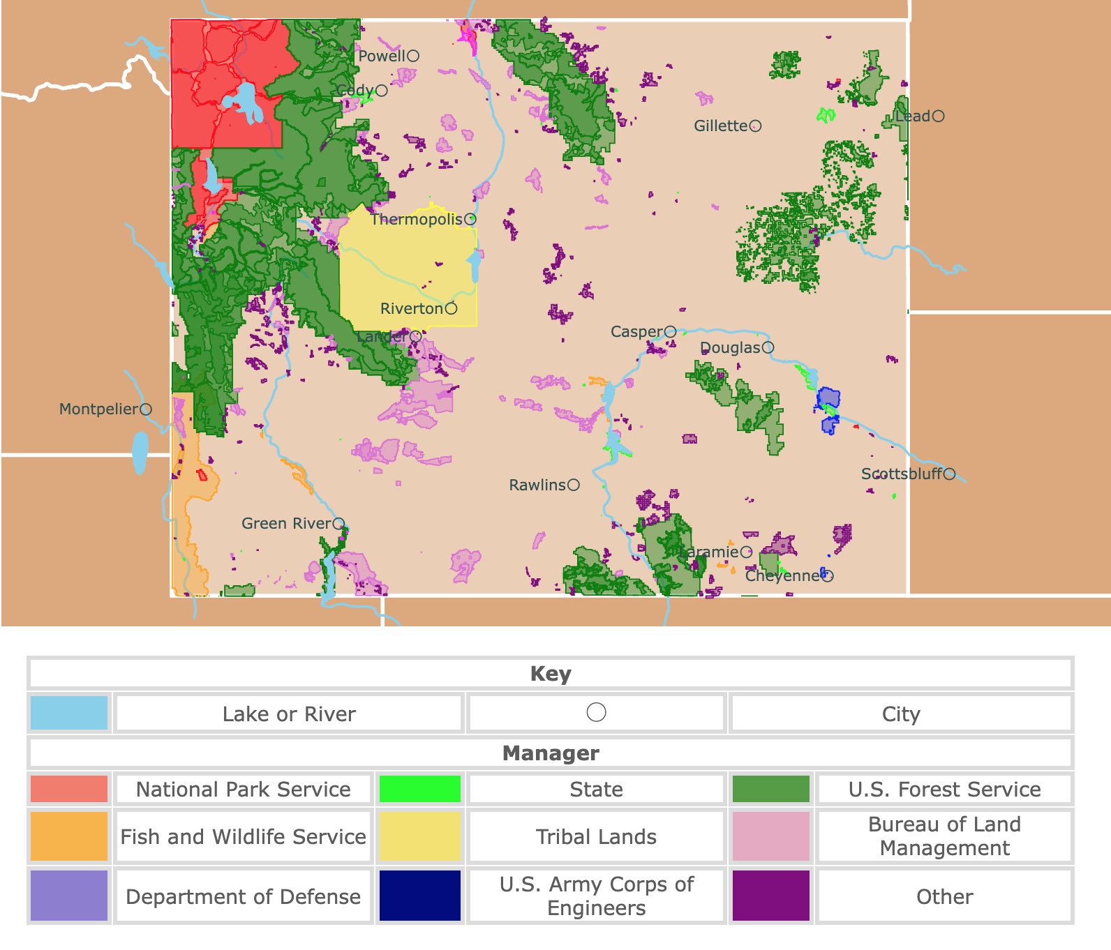
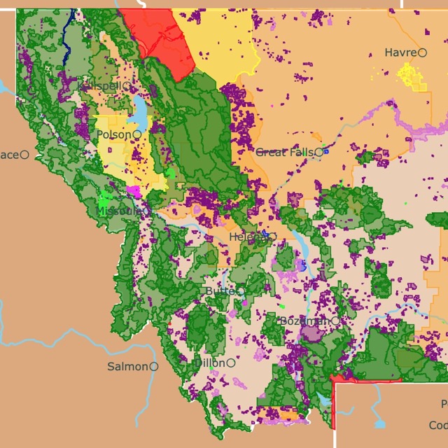
Map of Wyoming's Parks and Protected Areas
This interactive map shows the Locations, Names, Areas, and Details of National Parks, State Parks, National Forests, Tribal, and other Public Lands of Wyoming. It also shows major cities and rivers for context. For more detail, zoom in. For more information, hover over the map, or scroll down.
| Key | |||||
|---|---|---|---|---|---|
| Lake or River | ◯ | City | |||
| Manager | |||||
| National Park Service | State | U.S. Forest Service | |||
| Fish and Wildlife Service | Tribal Lands | Bureau of Land Management | |||
| Department of Defense | U.S. Army Corps of Engineers | Other | |||
Wyoming's Geography
Six states border Wyoming: Montana borders the north, South Dakota and Nebraska to the east, Colorado and Utah to the south, Idaho is to the west.
The state of Wyoming is divided into three regions.
- The Great Plains: The plains spread across the eastern portion of the state, and it is covered with short grasses and shrubs. The Great Plains region contains the Black Hills, where you'll find the Devils Tower National Monument, the first national monument.
- The Rocky Mountain Ranges: The Rockies run north to south, crossing most of the state. It's in the Rocky Mountain Range, where you'll find the Grand Teton National Park, as well as the Yellowstone National Park.
- The Intermontane Basin: This region lies between the mountain ranges and has few trees and short grasses. You can find the Red Desert in this area, which has the most extensive living dune system in North America!
The Grand Teton is located in the Teton mountain range and has an elevation of over 13-thousand feet (3,962 meters) above sea level.
Wyoming's summers are warm, wet, and muggy, with very cold, windy, and snowy winters. The state experiences partly cloudy weather all year long. Throughout the course of a year, the temperatures vary between 27 to 86 degrees Fahrenheit (-2.77 to 30 degrees Celsius).
The temperatures rarely drop below 14 degrees Fahrenheit (-10 degrees Celsius), and they don't typically rise above 94 degrees Fahrenheit (34 degrees Celsius).
While Wyoming is the 10th largest state, it's the least populated of all other states. One of the reasons the population is so low is the landscape. The high, rugged terrain isn't very welcoming and makes it challenging to build.
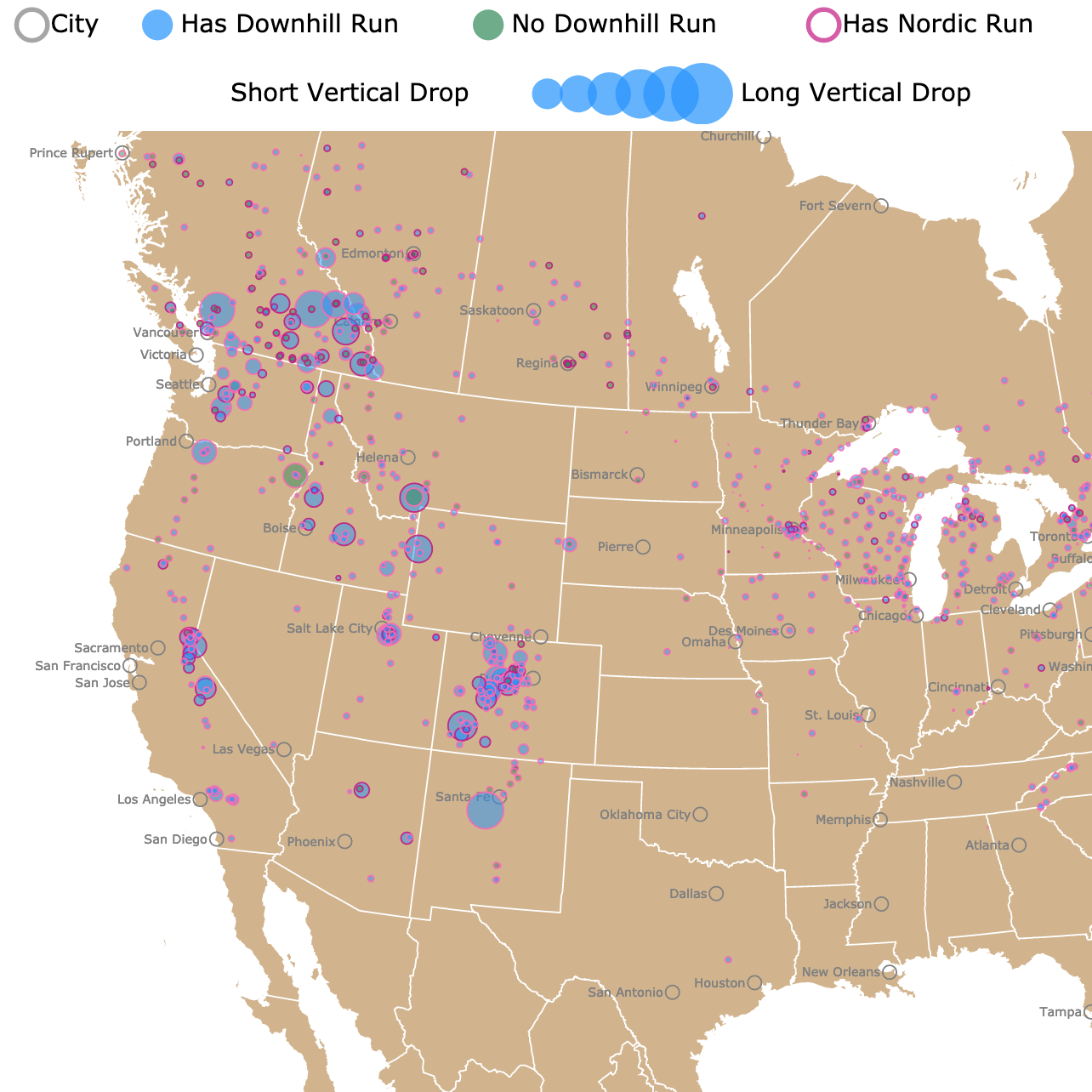
Interested in skiing? Check this map of Ski Resorts in North America
Plants and Animals of Wyoming
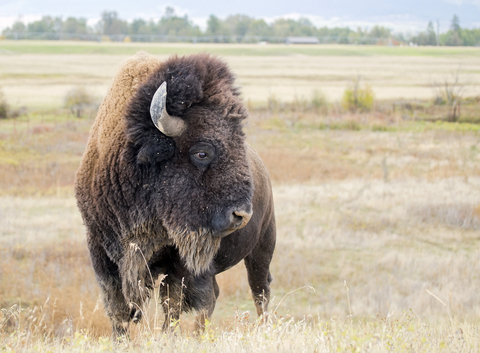
Many animals call Wyoming home. Pronghorn, buffalo, grizzly bears, black bears, and bighorn sheep are a few mammals you'll find in the state. You can see prairie falcons, pinyon jays, mountain bluebirds, and red-tailed hawks soaring Wyoming skies. There is quite an array of amphibians and reptiles to be found.
Sagebrush and Rocky Mountain juniper are two examples of the semi-desert and desert shrubs covering nearly all of Wyoming. You'll notice a lot of grasses across the state as well.
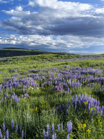
The state's forested regions are full of lodgepole pines, Douglas firs, and ponderosa pines. Wildflowers like the sticky purple geranium, pink fairies, and the Indian paintbrush (Wyoming's state flower) cover the land.
The highest or tallest mountain in Wyoming is Gannett Peak, with an elevation of 13,804 feet (4,207.46m) above sea level. That mountain doesn't stand alone, as there are eight more in the Northern Wind River Range.
Prairie grasslands can be found in Wyoming below 7,000 feet (2,133 m) in elevation. You'll find the prairies located predominantly in the eastern part of the state. However, they're also commonly seen in the basins of south-central and southwestern portions of Wyoming.
The state is home to several of the largest traveling dunes in the world. Sand dunes travel by wind; as the winds blow, the sand moves or shifts, changing shape and location.
Wyoming's National Park Service Areas
You'll probably want to read about Yellowstone National Park. We have an entire page dedicated to this incredible park since it's such a special area. For more amazing parks to discover, keep scrolling.
Grand Teton National Park
The Grand Teton National Park is represented as a red polygon in the northwestern corner of Wyoming.
The Grand Teton National Park is only a few miles south of Yellowstone National Park, and you can use the same visitor's pass at both locations.
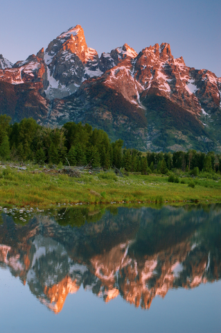
There are seven beautiful lakes at the base of the Teton mountain range. The Snake River is the headwater of the Columbia River system, and it's over 1,000 miles long. About 50 miles of this river is located within Grand Teton.
Somewhere around 10 million years ago, the Earth's crust began to stretch and thin. This stretching formed faults, which led to earthquakes.
Throughout time, the chunk of land west of the Teton fault shot upward toward the sky, creating the Tetons. The chunk of earth to the east of the fault sank or dropped over 20,000 feet (6,000 meters), forming the valley.
The Teton Range is the birthplace of extreme skiing. Skiing, backpacking, hiking, and wildlife watching are a few reasons the place is popular. The scenery is breathtaking, and the water is impressive.
Photographers love to capture wildlife and scenic photos at Grand Teton. There are several excellent areas where they can get stunning photographs of the mountain's reflection in the water. Schwabacher Landing and Oxbow Bend of the Snake River are two of the best places to get those photos.
There is a range of things to do at Grand Teton. Bike the long winding trails to explore the pathways explicitly designed for the incredible views. There are trails for beginners and experts.
You can enjoy fishing, hiking, mountaineering, scenic views, and wildlife viewing. Camp out under the stars or find a lodge nearby.
Want to find places to explore in nearby Montana? Check this map of Montana Parks
Fossil Butte National Monument
The Fossil Butte National Monument is located in the southwestern corner of Wyoming. It is depicted in red on the map.
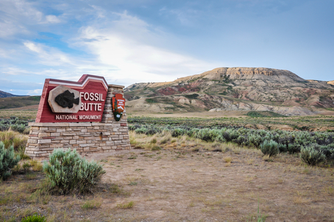
This 50-million-year-old lakebed, Fossil Lake, is a protected area.
Millions of years ago, when the lake was formed, southwestern Wyoming and surrounding states had large lakes where the sedimentary Green River Formation was deposited, leaving behind the fossils the park is known for today. The event was considered to be a geological phenomenon.
At Fossil Butte National Monument, you can explore one of the world's largest deposits of freshwater fish fossils. The area's calm waters, fine sediment, and the lack of scavengers worked together, creating the perfect conditions for preserving prehistoric fossils.
The Fossil Butte National Monument protects fossil Lake and parts of the Green River Lake. The Green River Lake's ecosystem is home to fish, turtles, alligators, bats, small horses, and plant fossils.
In the summer, you can join the Fossil Butte Quarry Program, which allows you to help search for fossils!
Unfortunately, you won't get to keep any of the fossils you find because they're used for scientific research.
The visitor center at Fossil Butte boasts over 300 fossils in a beautiful display. Enjoy a ride along the scenic drive, and stop for a picnic at one of the designated picnic areas. You can take a hike around the area and even attend a ranger program.
If you want to learn more about the Fossils, visit North America's Fossil Map
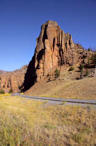
Devils Tower National Monument
The Devils Tower National Monument is located in northeast Wyoming; it is represented as a small red square on the map.
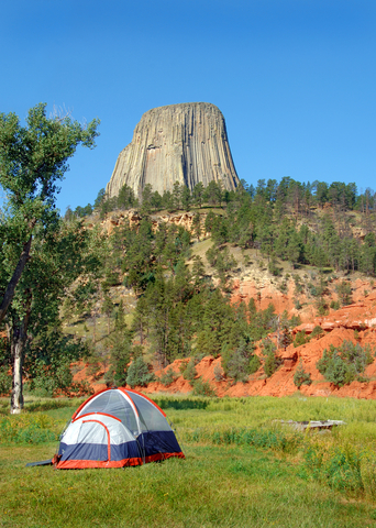
Devils Tower is a stunning geological feature protruding out of the Black Hills prairie. It is considered to be a sacred site by the Northern Plains Native Americans and Indigenous people of the area. The story behind the site's name comes from a Sioux Legend.
Most of the terrain surrounding Devils tower is sedimentary. That is brought in by wind and water. These depositions occurred for several million years.
Geologists agree that the tower itself started as magma or molten rock. They don't agree with how this magma cooled, protruded, and formed the tower. Nevertheless, the area is full of fossils and sedimentary rocks for visitors to admire, Devils Tower.
Today, skilled crack climbers scale the tower to make it to the top. The tower is 867 feet (264 meters) from the base to its summit.
Devils Tower Monument is an excellent place to learn about the culture of the First People, wildlife, nature, geology, and history. The diversity of the habitats surrounding the area is vast, which is surprising since it's not a very large area.
Wyoming's State Parks
Hot Springs State Park
Hot Springs State Park is a tiny lime speck by the city of Thermopolis.
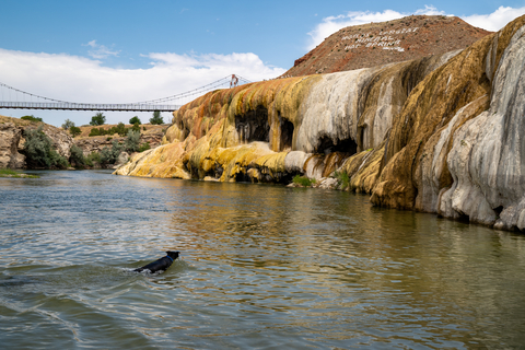
Hot Springs State Park is also known as the Big Horn Hot Springs State Reserve. It became the state's first state park in the late 1800s.
It didn't take long before the park became a popular site for tourists and those who wanted to experience the healing properties of the mineral-filled hot springs. Travel Wyoming
The park has a free bathhouse that's open to the public. The water is always 104 degrees Fahrenheit (40 degrees Celsius), the perfect temperature for therapeutic bathing.
Before a steamy bath or dip in the springs, enjoy walking across the Swinging Bridge. This suspension bridge crosses over the Bighorn River.
Besides the hot springs, visitors also come to the park to take a close look at the bison that live in the area.
The park is only open during the daytime, so there's no camping, but there is lodging around the area.
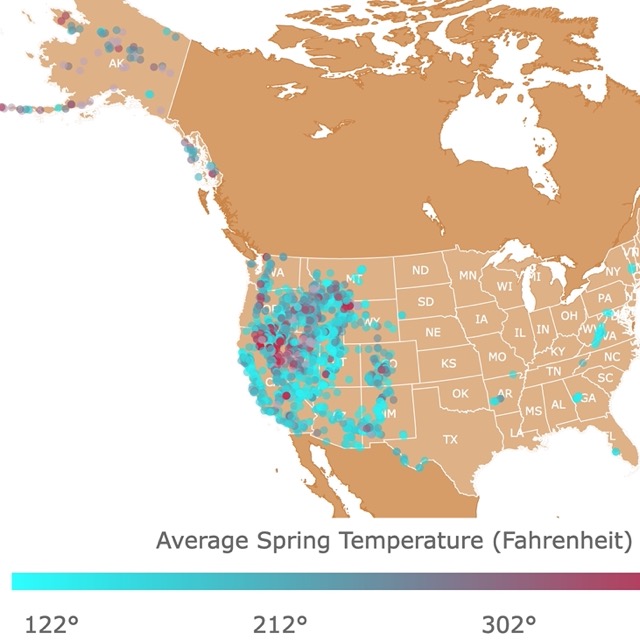
Want to find more Hot Springs? Visit this map of natural hot springs in the USA
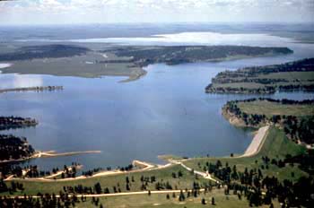
Boysen State Park
Boysen State Park is located just south of Thermopolis, Wyoming.
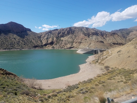
Boysen State Park is one of the largest state parks in Wyoming's State Park system. The park and reservoir were named after Asmus Boysen, who built the original dam in 1908, Boysen Dam.
A portion of the original dam can be seen adjacent to the Lower Wind River Campground tunnels. The Boysen Reservoir has a diverse fishery and is a popular location for angler fishers.
This lake-oriented park sits at the south end of the Owl Creek Mountains at the mouth of the Wind River Canyon. There is a variety of water-type recreation to enjoy, and it features interesting geological formations.
Enjoy boating, fishing, and ice fishing at the large reservoir and Wind River area. Cool off at the swimming beach at Brannon Campground. If you're into wildlife observation, you can try and spot pronghorn, deer, and an occasional Bighorn Sheep.
If you aren't interested in outdoor camping, you can rent one of the three cabins at the Upper Wind River Campground. The cabins are close to the water, so you won't have to travel far to enjoy a day out.
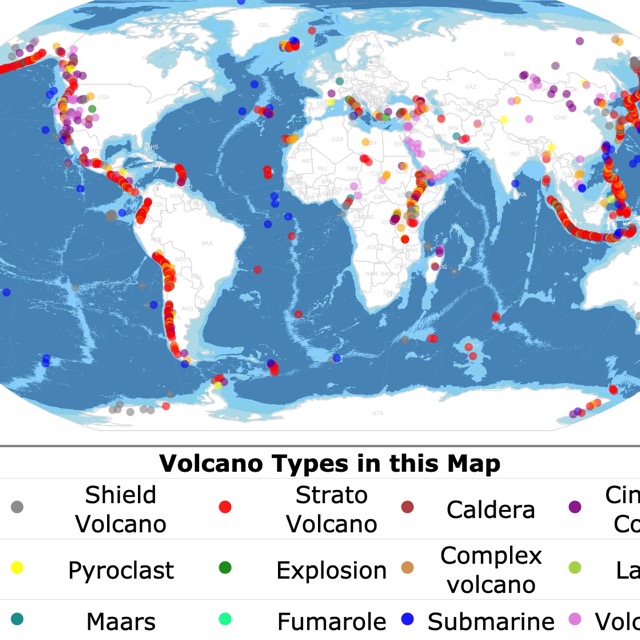
Volcanic activity still plays a role in Wyoming's formations. For more, click on this map of Volcanoes and types.
Buffalo Bill State Park
Buffalo Bill State Park is a small lime green polygon west of Cody, Wyoming. The park is only about 40 miles (64 kilometers) away from Yellowstone National Park's eastern entrance and 9 miles from Cody, Wyoming.
This park is an excellent place to explore the area's history, sightsee, and enjoy wildlife.
If you're looking for an area rooted in the rich lore of the Old West, this park might be the place for you. Buffalo Bill State Park was named after none other than Buffalo Bill Cody, the famous wild west showman, promoter, and developer William F. Cody.
Today, the reservoir offers excellent camping opportunities at North Fork and Lake Shore Campgrounds. You can also enjoy fishing, picnics, and boating.
The scenery is full of beautiful mountains. Rattlesnake Mountain frames Shoshone Canyon (where the dam is) to the north and Cedar Mountain to the south. Cedar Mountain is also known as Spirit Mountain. Look further to the west along the north shoreline, and you'll see Logan Mountain.
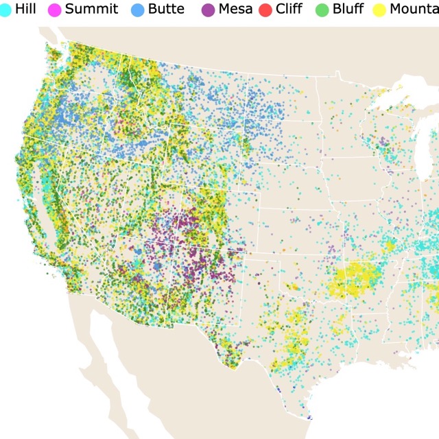
Interested in what kind of geologic formations are in Wyoming? Check this Map of Summits, hills, and peaks around the USA
Bear River State Park
Bear River State Park is a lime green polygon situated outside of Evanston in southwestern Wyoming.
Bear River State Park can only be visited during the daytime, and it spans across 324 beautiful acres of land. The park is home to small herds of elk and bison.
Bear River State Park offers several miles of paved and packed gravel trails to travel. Make sure you stop into the visitors center and see the numerous wildlife displays that showcase the impressive array of wildlife from the state of Wyoming.
Bear River is open all year long, but since it's only open during the day, you won't be able to camp.
There is plenty to do at the park while it's open. Enjoy a picnic, hiking, group activities, skiing, bicycling, rollerblading, and racing remote control cars.
There are three miles of foot trails to explore within the park limits, including 1.2 miles of paved pathways and an arched footbridge crossing the Bear River.
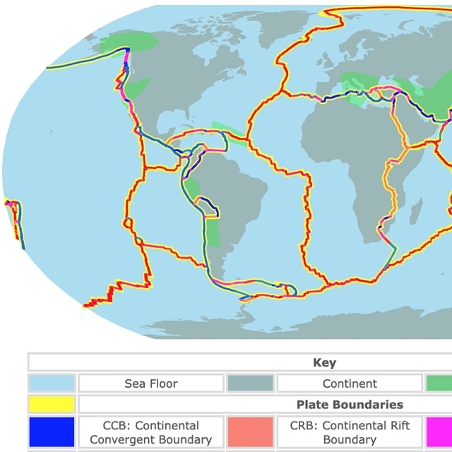
The processes that shaped Wyoming are still working today. To learn more, check this map of Tectonic Plates and Boundaries
Keyhole State Park
Keyhole State Park is situated in the northeast region of Wyoming and is represented by lime green. The park is located on the western ridge of the Black Hills, between Moorcroft and Sundance.
Some of Wyoming's largest fish have been caught at Keyhole State Park. Enjoy hiking, swimming, boating, water skiing, and bird-watching.
Keyhole has three group shelters that can be reserved for weddings or other events, Source: http://enjoyyourparks.com/uploads/Keyhole_State_Park_Map_and_Brochure.pdf. There are ten campgrounds to choose from, but you have to reserve a spot first.
Affiliate Disclosure
Databayou.com is a participant in the Amazon Services LLC Associates Program, an affiliate advertising program designed to provide a means for sites to earn advertising fees by advertising and linking to Amazon.com. Databayou.com also participates in affiliate programs with Clickbank, CJ, and other sites.
If you plan on visiting one of these parks, I suggest you get some of these items found on Amazon.
- PLUSINNO Fishing Rod and Reel Combos: Carbon Fiber Telescopic Fishing Pole, with Spinning Reel and Shielded Bearings, ideal for traveling.
- RESVIN Snow Shoes: for Men Women Youth, Lightweight Aluminum Terrain Snowshoes with Carrying Tote Bag. These snowshoes offer adjustable sizing, high quality, and lightweight.
- Camonity Digital Binocular with Camera: It has Zoom, Video, Photo, Recorder, and Camcorder for Bird and Wildlife Watching.
FOLLOW ME
Resources for Wyoming's Protected Areas Map
The shapefiles with Wyoming's state boundary lines, lakes, major rivers, and cities were downloaded from Natural Earth Data.
The Parks and Public Lands shapefiles for Wyoming were downloaded from USGS.
This map will be updated with new data! To receive updates on this and more nature maps join my email list!!!!!!!
Made by Luz K. Molina with D3.js.