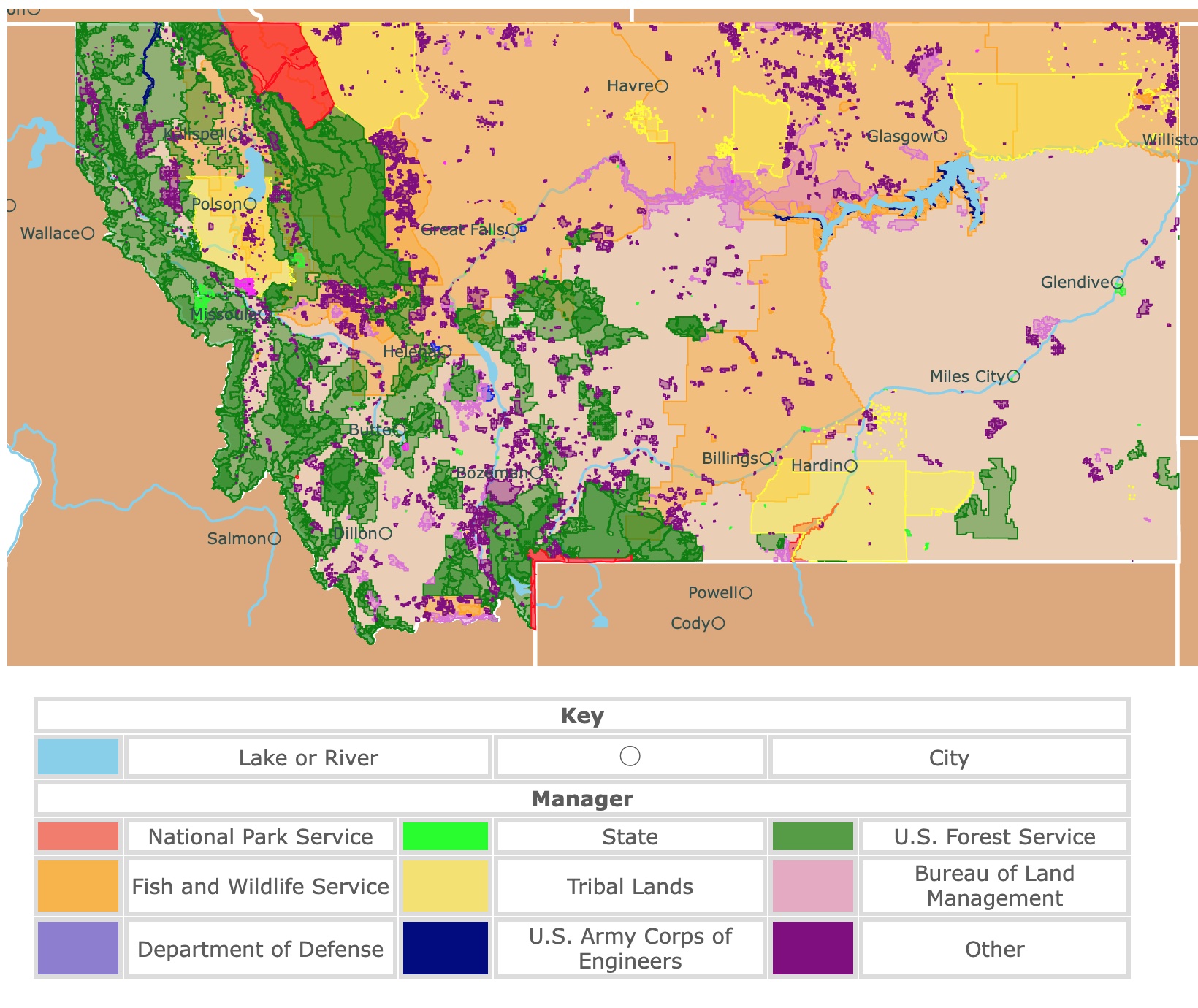
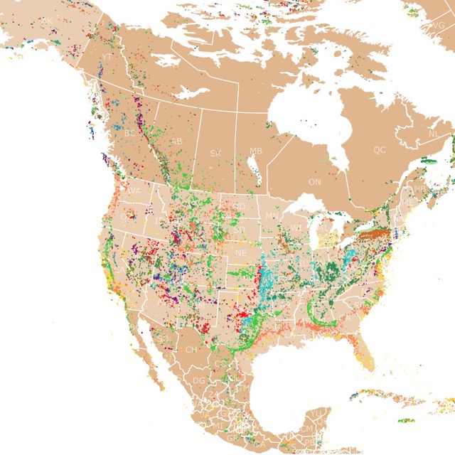
Map of Montana's Parks and Protected Areas
This interactive map shows the Locations, Names, Areas, and Details of National Parks, State Parks, National Forests, Tribal, and other Public Lands of Montana. It also shows major cities and rivers for context. For more detail, zoom in. For more information, hover over the map, or scroll down.
| Key | |||||
|---|---|---|---|---|---|
| Lake or River | ◯ | City | |||
| Manager | |||||
| National Park Service | State | U.S. Forest Service | |||
| Fish and Wildlife Service | Tribal Lands | Bureau of Land Management | |||
| Department of Defense | U.S. Army Corps of Engineers | Other | |||
Geography of Montana
Montana is a vast state full of mountains, forests, river valleys, caverns, badlands, and grassy plains. Montana is the fourth largest state in the nation.
Montana shares its borders to the west with Idaho, to the south with Wyoming, to the east with North Dakota and South Dakota. To the north ith shares its borders with Canada's British Columbia, Alberta, and Saskatchewan Provinces.
Montana might be the fourth largest state, but it's the sixth least populated. The city of Phoenix has a larger population than the entire state of Montana.
The word "Montana" is derived from the Spanish word meaning "mountain". The nicknames "Treasure State" and "Big Sky Country" are in reference to the divergent and beautiful landscapes that are encompassed within Montana's boundaries.
The state's motto, "Oro y Plata", Spanish for Gold and Silver. It was the large gold and silver mines that paved the way for the nickname "Treasure State".
The Native Americans called the Continental Divide the "backbone of the world." The Continental Divide gives Montana distinct watersheds. The Divide runs along the crests of the Rocky Mountains, all the way from Canada to Mexico, literally dividing the bodies of water of the North American continent.
The highest point in Montana is located at Granite Peak, with an elevation of 12,700 feet (3901 meters). The lowest point in the state is the Kootenai River, at 1,800 feet (549 meters).
There are 11 tribal nations across 7 Indian reservations located in Montana. There is a 12th tribe, the Little Shell Band of Chippewa, also living within the state; however, they don't own land.
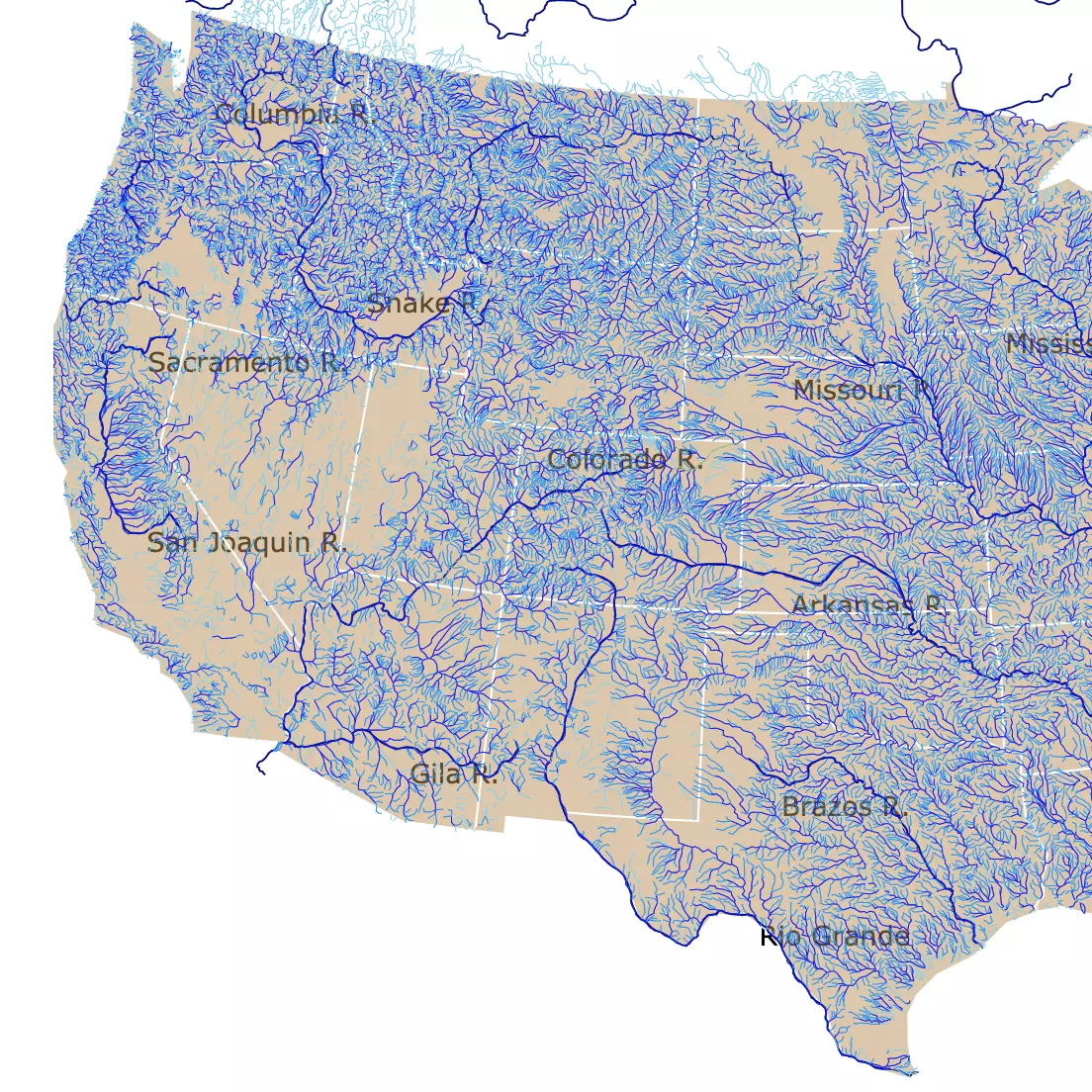
Many rivers begin in Montana. To find out which ones, visit this map of U.S. Rivers
Montana's Water Bodies
Some know Montana as the headwaters state because most of the water flowing to the rest of the nation comes from the mountains located in the state. Within Montana's borders, there are portions of two major river drainage systems of North America.
The Clark Fork, Bitterroot, Kootenai, Blackfoot, and Flathead Rivers join into the Columbia River that flows into the Pacific Ocean.
The two largest lakes in Montana are the Flathead (the largest freshwater lake west of the Mississippi River) and Fort Peck. Fort Peck is a manmade lake with over a thousand miles of shoreline.
Montana's Landscape
The eastern 1/3 of the state is plains, where the land has no limits.
The central 1/3 of Montana surrounds what is known as "island" mountain ranges.
The western 1/3 portion of the state is part of Yellowstone National Park. Home to the world's most extensive region of geyser activity with over 10,000 thermal features.
For comfy nights in West Yellowstone, Expedia has you covered. It has different hotels and inns for your needs. For more information visit this link!
In the northwest corner, you'll find Glacier National Park, where the incredible mountain peaks were cut and carved by glaciers over 10-thousand years ago. The far eastern part of Montana is home to Makoshika State Park, where you can find mysterious badland formations.
The Prairie Badlands are natural masterpieces of eastern Montana. Badlands are a type of dry terrain where softer sedimentary rocks and clay-rich soils have been eroded.
The sandstone and badlands sculpture displays can be found throughout Montana east of the mountains.
One of the best-known accumulations of the austere location is the Makoshika State Park, on the southern edge of Glendive. To the west of Makoshika State Park and across the Yellowstone River from a town called Terry are the Terry Badlands.
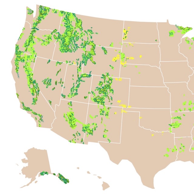
Map of National Forests of the U.S.
Montana's Climate
Montana has a northern Pacific coastal climate. You can expect cool summers and mild winters in the western region of the state.
However, the eastern portion, separated by the Continental Divide, has a semi-arid, continental climate where the summers are warm, and winter is cold.
The weather can vary greatly depending on where you are in the state. July boasts the peak summertime temperatures, averaging around 85°F (29.4°C). However, there have been a few summers with record high temperatures over one hundred. Ktvh
January often sees the coldest temperatures of the year. The coldest temperature on record was at Roger Pass, 40 miles (64.37 km) northwest of Helena (Montana's capital), logged at -70℉ (-56.67℃). Montana's Weather.
Annual snowfall in Montana reach up to 300 inches (25 feet) in the Rocky Mountains in the western half of the state. The east may get as little as 20 inches.
The snowfall accumulation, makes the state ideal for ski enthusiasts.
If you wish to stay near Whitefish Mountain Ski resort in Montana, VRBO has the cabin for you. These cabins are not far from Glacier NP and are a ready retreat. For more details click here!
Montana's National Parks and State Parks
Montana is home to several National Parks. However, there are two picturesque parks that stand out amongst the rest
Yellowstone National Park and Glacier National Park. While these two parks are incredible, the state has much more to offer visitors and locals.
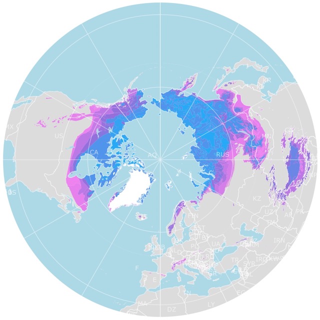
Cold areas like Glacier National park are likely to have Permafrost. To find out where it is, check this map of Arctic Permafrost
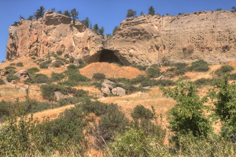
Lewis and Clark Caverns State Park
The Lewis and Clark Caverns State Park is located halfway between Butte and Bozeman, Montana. It is the speck represented in lime green on the map above.
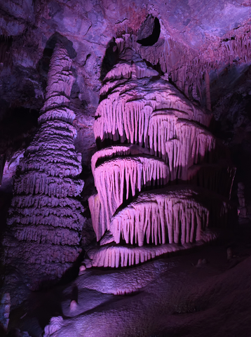
Lewis and Clark Caverns State Park is home to one of the largest limestone caverns located in North America. It's Montana's first state park, and it's extremely well-known too. The cave can only be accessed by guided tours and isn't open during the winter.
The caves in Lewis and Clark Caverns State Park are naturally air-conditioned with columns, stalagmites, stalactites, and helictite that are electrically lit.
Special care is required while visiting the cave, not just because of its nature but because of the bats inside the caves.
You can visit the aboveground, self-guided natural trails to get a glimpse and understanding of the plant and wildlife surrounding the area.
You can hike along the 10-miles (16.09 km) trails. You'll find a campground with 40 camping spots and three cabins. The park is open all year long, but the guided tours are limited to the warmer seasons.
The site consists of 3.000 acres at 4,300 and 5,600 feet (1.31 and 1.71km) in elevation. Take a trip to Three Forks and Whitehall and visit the beautiful museums and golf courses. The Lewis and Clark Park is west of Three Forks on Montana Highway 2 or 17 miles east of Whitehall on the same highway.
If you're down for a bit of adventure, you can visit the Albro Lake Trail in Ennis, Montana, or check out the Alpaca land farm tour in Belgrade, Montana, L&C Caverns.
There are lots of other caves to explore in the U.S.; to find where they are, click on this map of U.S. caves
Flathead Lake / Big Arm State Park
The Flathead Lake State Park is a system that encompasses six different park units that run through Flathead Lake. The parks include Yellow Bay, Finley Point, and Wayfarers, which are located on the eastern side of the lake, and the west shore. On the west side, you'll find Big Arm and Wild Horse Island.
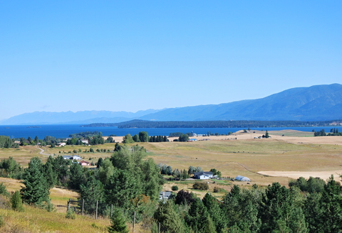
Flathead Lake is one of the clearest lakes in the world, it is also one of the cleanest in the western U.S.
The lake has trout, yellow perch, whitefish, pikeminnow, northern pike, and sturgeon.
The park has several great opportunities for camping, renting yurts, hiking, picnicking, and sightseeing. Flathead Lake is the largest natural freshwater lake located west of the Mississippi. You'll find over 200 square miles (322 square km) of water to enjoy.
Polson, Montana, is located on the southern shore of Flathead Lake. Flathead Lake is accessible from US Highway 93 between Kalispell and Polson.
You can spend the night in beautiful lodges and cabins surrounding the lake. For options and prices, visit VRBO.
Giant Springs State Park
Giant Springs is located next to the Great Falls and is represented in lime green on the map above. Giant Springs was recorded first by Lewis and Clark in the 1800s. It is one of the largest freshwater springs in the entire country.
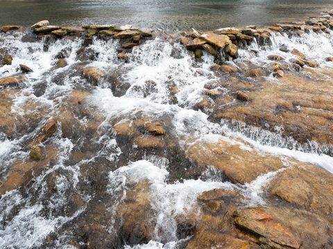
The springs are located outside of the Great Falls, encompassing close to 14 miles (22.53 km) of the Missouri River shoreline. Giant Springs produces more than 150 million gallons of water daily. The rushing waters from the spring flow into the Roe River. Roe River was once listed in the Guinness Book of World Records as the shortest river.
You can take a trip for the sheer beauty, fishing, a hike, or a nice bike ride. Regardless, you'll have a beautiful experience that you walk away with. You'll find miles of single-pathed trails that are paved, and some are still dirt, Giant Springs.
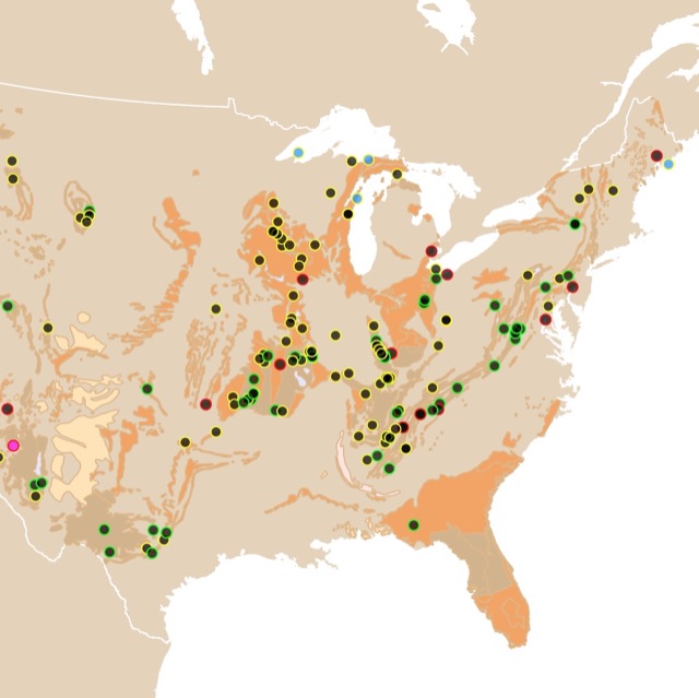
Map of Northamerican Fossils
Pictograph Cave State Park
Pictograph Cave State Park is represented as a tiny lime green speck next to Billings, Montana.
The Pictograph, Ghost, and Middle Caves were once home to prehistoric hunters. There is a loop trail that can be followed to view the pictographs or cave paintings that are still visible after all these years.
The site was designated a National Historic Landmark back in the 1960s due to its archeological significance. The oldest rock art within the cave dates back more than 2-thousand years ago.
Over 20-thousand artifacts from instruments, stone tools, to weapons, and paintings. It's ok if you don't know what the pictographs say because there are interpretation displays available for every section.
Sluice Boxes State Park
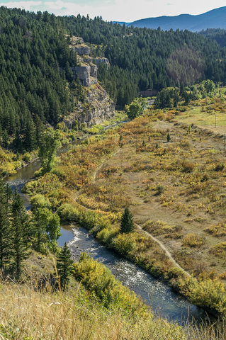
You'll find Sluice Boxes State Park to the northeast of Helena. This park is represented in lime green.
This park is a public recreation area within the Little Belts Mountain of Montana. It's 12 miles (19.31 km) south of Bell, Montana, along the Kings Scenic Byway.
You'll find remains of mines, historic cabins, and the railroad lining Belt Creek. The beautifully carved cavern is made from limestone.
Sluice Boxes is a rugged location for hikers who love adventure. It is an unmaintained trail, so only the fittest will survive.
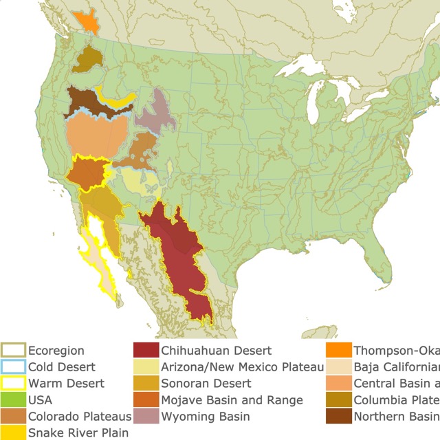
In case you want to learn more about deserts in the U.S., check this map!
Makoshika State Park
Situated on the eastern side of the state is the small lime green polygon next to the city of Glendive. Makoshika State Park is the largest state park in Montana.
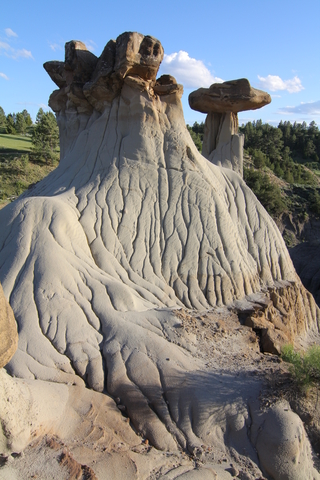
This park is characterized by its badlands. The Badlands have scattered juniper and pine, making them ideal for sightseeing and hiking.
Makoshika is also sought after for its fossil remains. The park has had 10 dinosaur species discovered in its grounds. These include: Triceratops horridus, Edmontosaurus, Tyrannosaurus rex, and a the rareThescelosaur. They are housed in the visitor center for travelers to observe.
In the park, it is also possible to see the K-T boundary line. This is the physical remnant of the transition between the Cretaceous and the Tertiary periods. This period is characterized by the mass extinction of dinosaurs!
The park has scenic drives, hiking trails, and camping sites. Makoshika
The beauty in and around Montana is genuinly astounding. There is so much untouched natural beauty to see. There is something for everyone.
FOLLOW ME
Resources for Montana's Protected Areas Map
The shapefiles with Montana's state boundary lines, lakes, major rivers, and cities were downloaded from Natural Earth Data.
The Parks and Public Lands shapefiles for Montana were downloaded from USGS.
This map will be updated with new data! To receive updates on this and more nature maps join my email list!!!!!!!
Made by Luz K. Molina with D3.js.