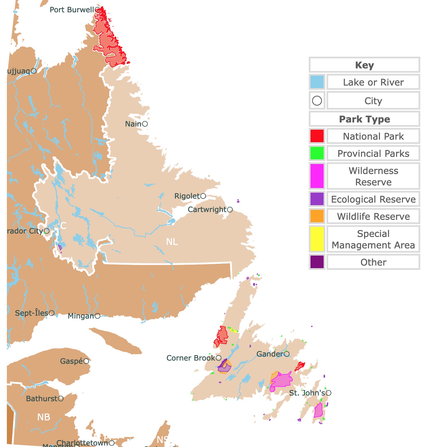
Map of Newfoundland and Labrador's Parks and Natural Areas
This interactive map shows the Locations, Names, Areas, and Details of National Parks, Provincial Parks, and Natural Areas of Newfoundland and Labrador. It also shows major cities and rivers for context. For more detail, zoom in. For more information, hover over the map, or scroll down.
| Key | |
|---|---|
| Lake or River | |
| ◯ | City |
| Park Type | |
| National Park | |
| Provincial Parks | |
| Wilderness Reserve | |
| Ecological Reserve | |
| Wildlife Reserve | |
| Special Management Area | |
| Other | |
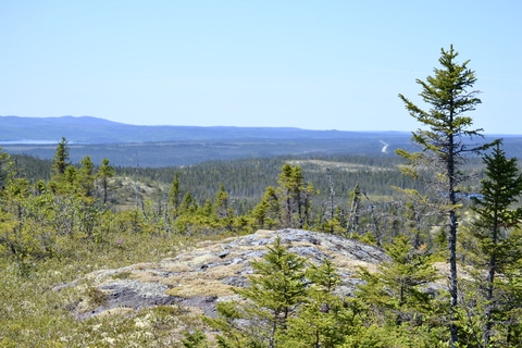
Geography of Newfoundland and Labrador
The name Newfoundland is a translation of the original name in Latin and Portuguese, "Terra Nova". Labrador is named after João Fernandes Lavrador, a Portuguese explorer.
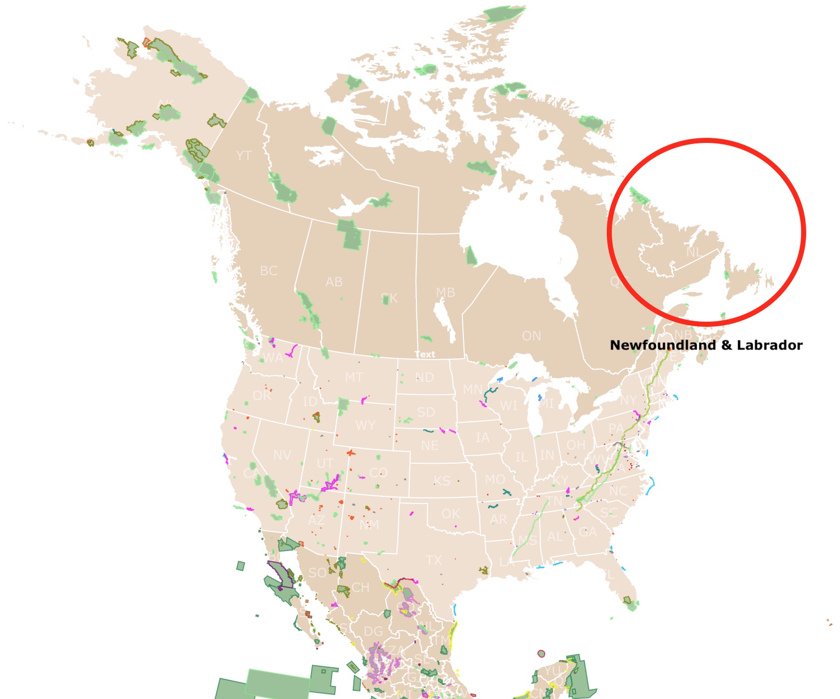
Newfoundland and Labrador is a province in the northeastern corner of Canada. This province shares a border with Quebec and is surrounded by the Gulf of St. Lawrence, the Labrador Sea, and the Atlantic Ocean.
Newfoundland and Labrador is divided into the Canadian Shield in Labrador and the Appalachian and Eastern St. Lawrence Lowlands on the beautiful island of Newfoundland.
The northern coastal region of Labrador is mountainous, grows only ground-level vegetation, and contains fjords. Labrador's southern coast is rugged and includes barren foreshore and a forested hinterland.
On the island of Newfoundland, the west coast is dominated by the incredible Long Range Mountains. The island's northeast coast includes numerous islands, bays, and headlands on the Atlantic Ocean shore.
Labrador is situated in the easternmost portion of the Canadian Shield. The Shield consists mainly of rugged, ancient Precambrian igneous and metamorphic rocks, with some areas of softer sedimentary rocks, more so in the west where you'll find a formation called Labrador Trough.
The island of Newfoundland is a part of the Appalachian system and contains peninsulas, mountain ranges, and river systems. The rocks in this region are more varied than in Labrador.
The interior regions of Labrador and Newfoundland are scattered with lakes and are covered with moraines. A Moraine is material left behind by a moving glacier and usually consists of various rocks and sediment.
Most coastal regions contain fjords where ice channeled down through the valleys of what is known as the pre-glacial fluvial system. The longest and steepest fjords are in northern Labrador and around the Great Northern Peninsula of Newfoundland.
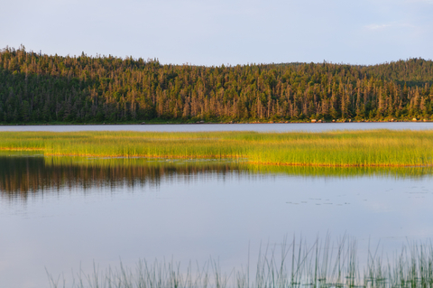
The glaciation in these regions left landscapes capable of storing vast amounts of water in thousands of ponds, lakes, and bogs.
Most lakes are in large, old valleys deepened by glacial scouring and dammed by glacial deposits. The interior of Labrador comprises hundreds of lakes that have been combined with canals, dams, and dikes to create the Smallwood Reservoir.
The moist climate and plentiful snowfall mean the water table is high in all the province areas. Rivers flow perennially, and the lakes are typically full. Water shortages are relatively rare.
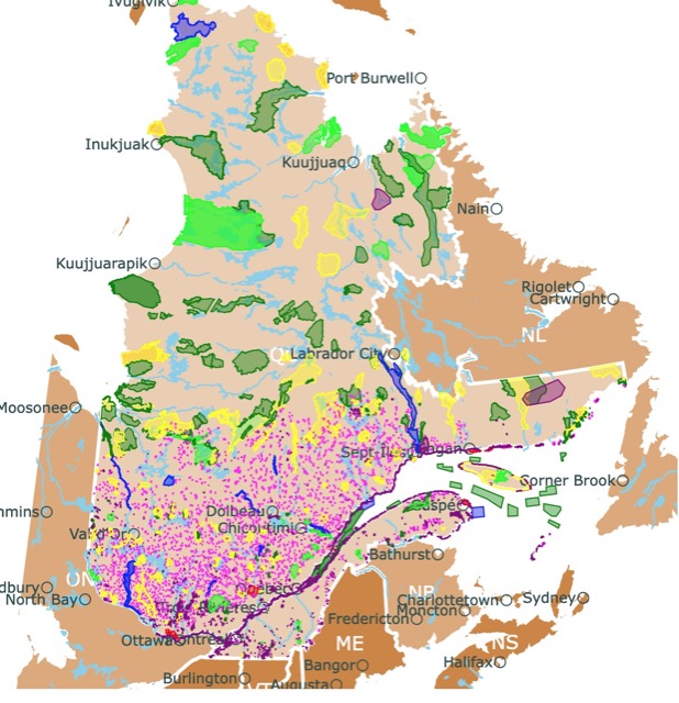
Want to find places to explore in nearby Quebec? Check this map of Quebec Province Parks
Newfoundland's & Labrador's Climate
The climate varies significantly throughout this province. Northern Labrador experiences a subarctic climate with general coolness and dryness throughout the year.
The average maximum temperatures in Nain during January are about 8℉ (-13℃), and 59℉ (15℃) in July.
The minimum temperatures drop to -4℉ (-20℃) in January and 41℉ (5℃) in July. Winter in Labrador's interior is extremely cold as well.
Newfoundland & Labrador's Wildlife
Most of the province's interior is relatively uninhabited. There is a greater variety of wildlife in Labrador than on the island of Newfoundland.
Some of the large game animals that call the area home include moose, caribou, and black bear. In the northern coastal areas, polar bears roam free.
Many small fur-bearing animals in the province include fox, lynx, rabbit, beaver, and muskrat.
Millions of seabirds nest annually in many coastal areas, primarily murres, gannets, gulls, puffins, and kittiwakes.
Established sanctuaries protect the birds in six provincial ecological reserves, including the Gannet Islands off the Labrador coast. Three migratory bird sanctuaries are in Terra Nova National Park and Grey Islands.
National Parks of Newfoundland and Labrador
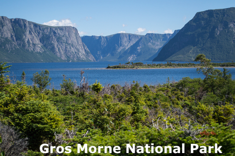
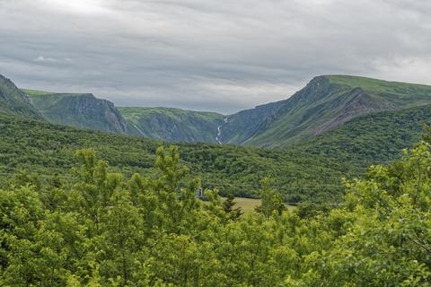
Gros Morne National Park
The red area in western Newfoundland is Gros Morne National Park. The park is 697sqmi (1,805 km2), the second-largest in this province.
Its French meaning is “large mountain standing alone” or “great somber.” The name was taken from the second most prominent peak in Newfoundland at 2,644 ft (806m).
Imagine incredible fjords and towering mountains high above a diverse landscape of forests, bogs, beaches, and barren cliffs.
Colliding continents and grinding glaciers formed Gros Morne National Park. Today it is a UNESCO World Heritage Site.
Visitors are encouraged to walk the Tablelands. This is where the theory of plate tectonics was confirmed! Visitors can walk on an ancient sea floor, a particular red landscape of exposed Earth's mantle.
From the Tablelands, visitors can descend through boreal forests to the volcanic seacoast and reach coves and beaches.
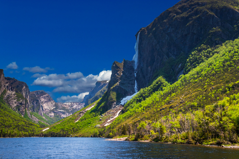
The coastal pathways are inviting, and the warm beaches welcome visitors to beach comb or build sandcastles. Enjoy a cruise along the gorge of Western Brook Pond.
Visitors can explore the colorful culture within the nearby seaside communities. Stay for a while and learn about Newfoundland's rural culture.
The cliff-lined freshwater fjord makes for an excellent explorative cruise. There are over 120 miles (200Km) of inland bays and coastlines! Visitors can explore the area independently or participate in guided activities like interpretive walks and boat trips.
Wildlife lovers can try to spot caribou, moose, bald eagles, whales, and seals.
There are over 63 miles (100Km) of trails for hiking and biking, allowing visitors a deeper exploration of the area. There is also sea kayaking, paddle boarding, canoeing, fly fishing, and lobster fishing.
Take some time to explore the historic Lobster Cove Head Lighthouse. Spend a few days or a week camping in the backcountry or reserve an oTENTik. Source: grosmorne.com.
Comfortable and convenient oTENTik, are great for staying the night, but you will probably want to take a cozy sleeping bag for cold locations. Amazon has the Hike and Bike Sleeping bag. This ultra-light sleeping bag is insulated, perfect for cold weather, hydrophobic, and has anti-snag zippers. For sizes and details, visit this link!
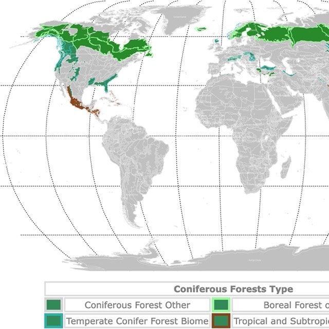
Map of Conifer Forests Worldwide
Torngat Mountains National Park
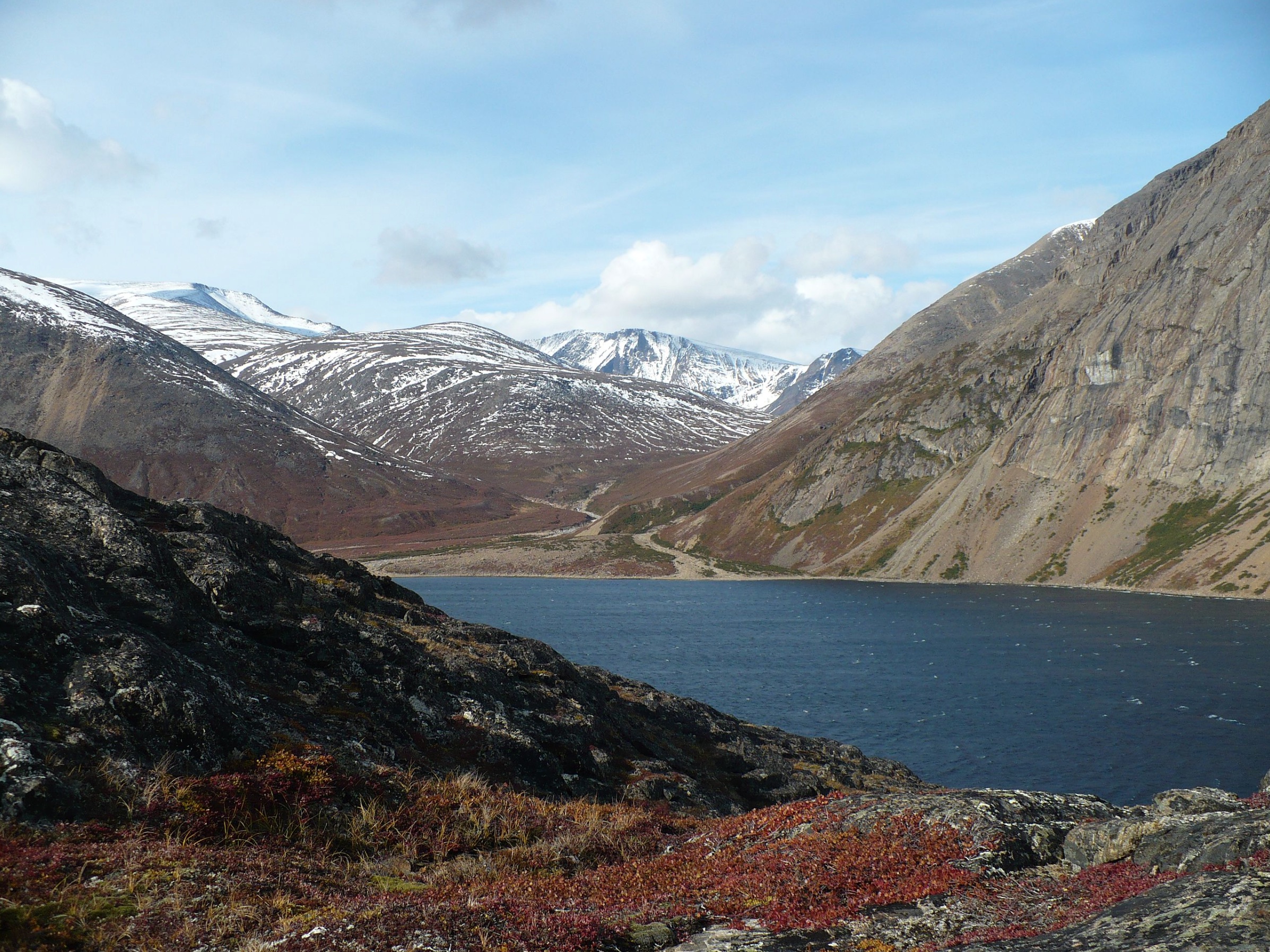
The Torngat Mountains is the large red area on the map in northern Labrador.
The park is a dramatic landscape of glacier-carved fjords, saw-toothed skyline, and iceberg-dotted waters. Here are some of the Earth's oldest rocks.
The superlative mountains and valleys have gray, green, and peach tints. This is the largest park in Atlantic Canada.
The Torngat Mountains are an Inuit homeland full of powerful stories, spirits, and traditions. The Inuit people welcome visitors to join them through the dramatic landscape rich with culture and nature.
Torngat is a remote park. Visitors can make their way into the park by the sea, air, or on foot. Enjoy a beautiful boat trip through the fjords, and see icebergs while learning about spiritual places, including sacred Inuit gravesites.
Hiking across the tundra provides the opportunity to see bears and caribou. It leads to incredible waterfalls and a pristine lake. The Inuit people will keep you company, share Arctic lunches, and welcome you for a cup of hot tea.
A trip to Torngat Mountains National Park opens the door to a wealth of outdoor recreation. Mountain climbing, hiking to the lookout for incredible views, backcountry camping, mooring, kayaking, and stargazing are a few popular activities.
Be ready to spot caribou as they roam the lands while whales roam nearby waters.
The park features various programs and tours throughout the year as well; Torngat.
The weather here is unpredictable so make sure you bring warm clothes. Amazon has the Eddie Bauer Superior Down Parka. This jacket is made of nylon, with superior insulation, waterproof and breathable, and can withstand rain, sleet, snow, or hail. It comes with a detachable hood with faux fur, which is comfortable and warm for the coldest days.
Terra Nova National Park
Terra Nova National Park is the red area in eastern Newfoundland. This park comprises over 150 sq miles(400Km2) of pristine land.
Terra Nova is Canada's most Easterly National Park. The island's boreal forest reveals its natural and cultural history as visitors explore hiking trails and marvel at the skyline. The land and sea will compete for your attention in this magical place.
Black spruce, ash, balsam fir, tamarack, white pine, and different deciduous trees cover the hills. The forest is broken by rock formations, ponds, and wetlands.
Go kayaking and canoeing; there are sheltered coastlines, rocky cliffs, and hidden coves, or paddle the rivers and lakes.
Wildlife at the park includes red fox, black bear, beaver, coyote, and caribou. Sea animals include harp seals, humpback whales, minke whales, fin whales, pilot whales, dolphins, and killer whales!
The Visitor Center should be the first stop. It's located along the shoreline of Newman Sound, in the Hub of the park. Visitors will find interpretive activities, a touch tank, a bird sanctuary, and Happy Adventure Tours.
Terra Nova National Park is a gateway to outdoor adventure; spend a few nights camping under the stars in the backcountry, or enjoy the peaceful nature surrounding you. Outdoor recreation opportunities are abundant.
The park features tours and programs for all ages, including junior programs, guided walks, theatrical programs, and several school programs; Terra Nova.
The best way to travel to Newfoundland is by flying from Toronto to St. John. Expedia offers great deals on different dates and times. You can check them by clicking here!

Newfoundland & Labrador has a beautiful coast. To learn more about it, visit this map of North America's Marine Ecoregions
La Manche Provincial National Park
La Manche is the lime speck on Newfoundland, south of St. Johns. The name means "the sleeve" in french because the harbor has long and narrow sides.
La Manche Provincial National Park is a nature lover's paradise! The park features a mesmerizing waterfall, trails, and ponds filled with lily pads.
Vegetation at the park ranges from boreal forest to marsh. Vegetation includes larch, birch, honeysuckle, Labrador tea, and tall meadow rue.
With over 50 species of birds in the area, it's an excellent site for birdwatching. Some birds are Common Eider, Shape-shinned Hawk, Common Snipe, Black Duck, Common Loon, Herring Gull, Common Tern, Yellow-bellied Flycatcher, and more.
Visitors can enjoy walking or hiking in the woods, canoeing, swimming, meandering in streams, and wildlife watching.
Adventurers can take a trail to the suspension bridge leading to the abandoned village of La Manche. Whale watching and iceberg viewing are two incredibly popular activities at La Manche.
Arches Provincial Park
Arches Provincial Park is the lime speck north of Corner Brook.
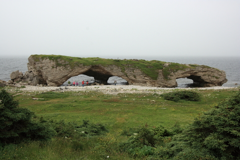
Begin your journey on a short path to the beach, where there are huge rock formations. The park is home to massive, porous rocks that ocean waves have lashed for millennia. These rocks formed the three natural arches you will find today.
While Arches Provincial Park didn't open to the public until 1972, visitors have been photographing the sight as long as cameras have been around.
At one time, there were four arches, but the constant erosion led to their demise. Eventually, the tides and wind will deteriorate the three remaining arches.
With over 18,019 miles (29,000Km) of coastlines, visitors love exploring the beach and hiking the dense and inviting tuckamore forest.
Wildlife watching, stargazing, camping, hiking, picnics, and beach fun are a few of the recreational opportunities. Feel free to bring your canine friends, just be sure to have them on a leash during your Arches Park adventure.
This park is protected, so not even camping is allowed; Arches.
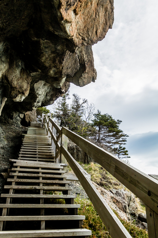
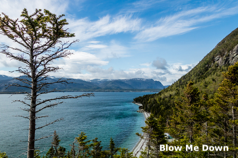
Blow Me Down Provincial Park
Blow Me Down is the lime speck in the Bay of Islands, Newfoundland, west of Corner Brook.
Tourists come to enjoy the fantastic views of the mountains and the bay.
Another reason visitors like the park is because of Governor's Staircase. This is a unique staircase shaped by rocks formed over 459 million years ago with volcanic rock. Today the stairs have wooden rails. Visitors can see the quartz veins on the rocks!
The park is an excellent destination for camping and outdoor recreation. It also features a lovely cobble saltwater beach in its day-use area.
Popular activities include birdwatching, cycling, camping, kayaking, wildlife watching, stargazing, snowshoeing, and picnics. Blow Me Down is dog-friendly, so you can bring your tail-wagging friends along for the adventure.
The park hosts various events throughout the year, including an annual Canada Day celebration with exciting activities for the entire family; Blow me Down.
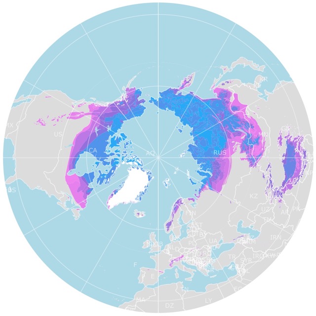
World Map of Arctic Permafrost
Dungeon Provincial Park
Dungeon Provincial Park is the speck in Newfoundland, southeast of Gander.
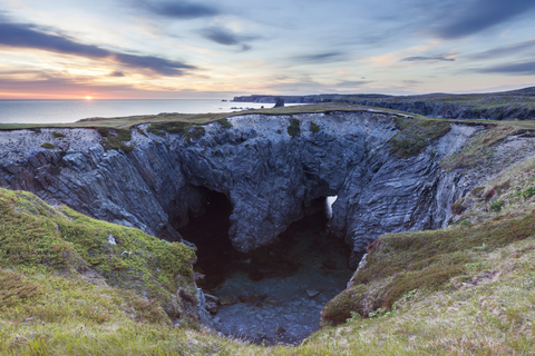
The end of the Bonavista Peninsula offers a breathtaking feature. The grassy bluff overlooks the ocean, where a massive heart-shaped crater has two separate openings to the sea.
What was once a sea cave became the heart-shaped rock visitors admire today.
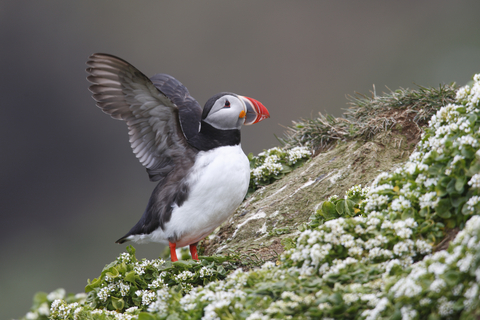
The shoreline is extensive and beautiful. This setting is perfect for the Atlantic Puffin. A large flock of them is easy to find at the park.
The wildlife watching opportunities are abundant at the Dungeon. Picnics, stargazing, hiking, walking, and a day at the beach are activities park goers appreciate.
This day park is dog-friendly, but remember to keep your canine companion on a leash! Dungeon.
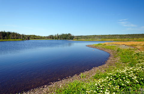
Codroy Valley Provincial Park
Codroy Valley Provincial Park is the lime speck in the southwest corner of Newfoundland.
The Codroy Valley is magnificent and features incredible pastoral settings. The beach at Codroy Valley Provincial Parks is one of the most prominent features.
The white sandy shoreline isolates the Atlantic Ocean from the Grand Codroy River, and the Long Range Mountains make a stunning backdrop for a day at the beach.
These beaches are protected nesting grounds for the endangered Piping Plover.
Piping Plovers are only about 6 to 7 inches (17-18 cm) tall; Canada Gov. Regardless of the size, birdwatchers love to come to the beach to see the various birds at the park.
The park is only open for day-use recreation, so there are no campgrounds, but lodging is available in the surrounding area.
Hiking, fishing, stargazing, wildlife observation, bird watching, beaches, and picnics are just a few activities possible.
Your canine companions are welcome at the park as long as they are on a leash.
Something to be aware of is that since the area is a fragile nesting ground, it's crucial to watch the signage to avoid harming their habitat; Codroy.
Chance Cove Provincial Park
Chance Cove Provincial Park is the lime speck south of St. John, in the southeast corner of the Avalon peninsula.
The park stretches from the highway's edge down to a trail leading to the coastline.
Whales, seabirds, and seals are some creatures living around the park.
Chance is a great location to walk by a cobblestone beach, hike, bike, and go bird watching..
It's believed that Chance Cove was named after a fatal shipwreck that took place along the coast.
It is said that the number of shipwrecks that have taken place in the Newfoundland and Labrador regions is somewhere in the thousands.
The park offers an abundance of outdoor recreation, from fishing and hiking to stargazing and birdwatching; Chance Cove.
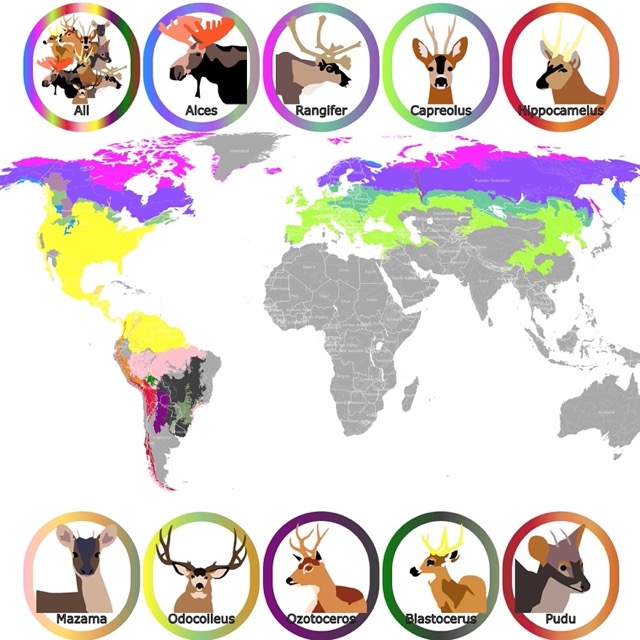
World Map of Moose, Deer, and Caribou Geographic Range
Cataracts Provincial Park
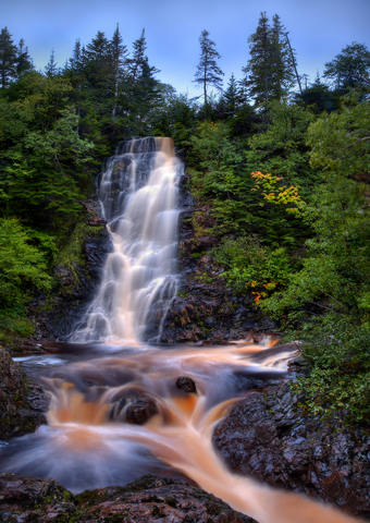
Cataracts Provincial Park is the lime speck on the map, southwest of St. John, near the community of Colinet in the northwest arm of St. Mary's Bay in Newfoundland.
The park has a deep river gorge containing cascading waterfalls. The journey at Cataracts Provincial Park leads you down a set of stairs and over walkways allowing you to cross the river rushing below your feet.
The bridge over the gorge is an arch bridge from the 1920s, the only of its kind in the province.
The day park is an incredible place to spend the day exploring nature, watching wildlife, and checking out the unique architecture. Birdwatching, wildlife observation, hiking, and cooling off in the waterfall are popular activities; Cataracts.
Butter Pot Provincial Park
Butter Pot Provincial Park is the lime speck on Newfoundland, half an hour southwest of St. Johns.
Butter Pot Provincial Park is a top-rated park in Newfoundland and Labrador. The name comes from Butter Pot which is a prominent rounded hill.
The park was covered by glaciers during the last glaciation 10,000 years ago. The glaciers sculpted the land and left large boulders along the way when they melted. These displaced boulders are called erratics. You will see them as you explore the park.
The park also has forests and bogs worth visiting. Nevertheless, ponds at Butter Pot are one of the major attractions with various swimming spots, paddling opportunities, and fishing.
Climb to the top of Butter Pot Hill to see all the major bodies of water from above. Other activities include going to the beach, biking, hiking, bird watching, and camping; Butter pot.
Once visitors arrive to St. John, they find driving a car is the best way to reach Newfoundland parks. Expedia offers different car brands for rent, just a click away. For more details follow this link!
J.T. Cheesman Provincial Park
J.T. Cheesman Provincial Park is the lime speck in the southwestern corner of Newfoundland.
J.T. Cheeseman Provincial Park is only six miles (10 km) from the Marine Atlantic Ferry Terminal in Channel-Port aux Basques.
The park features forested hills, bogs, incredible flora and fauna, a spectacular waterfall, a sandy beach, and a freshwater coastal lagoon.
There are over 90 campsites at the park, and 22 of them offer electricity. Group campsites are also available, and if you're new to camping, there is a ‘learn to camp' campsite that teaches beginners how to camp.
The list of recreational opportunities is very lengthy, but we can say you shouldn't be bored for a minute here.
Resources for Newfoundland and Labrador's Protected Areas Map
The shapefiles with Newfoundland and Labrador's state boundary lines and cities were downloaded from Natural Earth Data.
The national Parks of Canada shapefile was downloaded from Open Canada.
The shapefile with Newfoundland and Labrador were downloaded from Newfoundland and Labrador GIS Data.
The shapefile with rivers and lakes from Canada was downloaded from Open Canada.
This map will be updated with new data! To receive updates on this and more nature maps, join my email list!!!!!!!
Made by Luz K. Molina with D3.js.