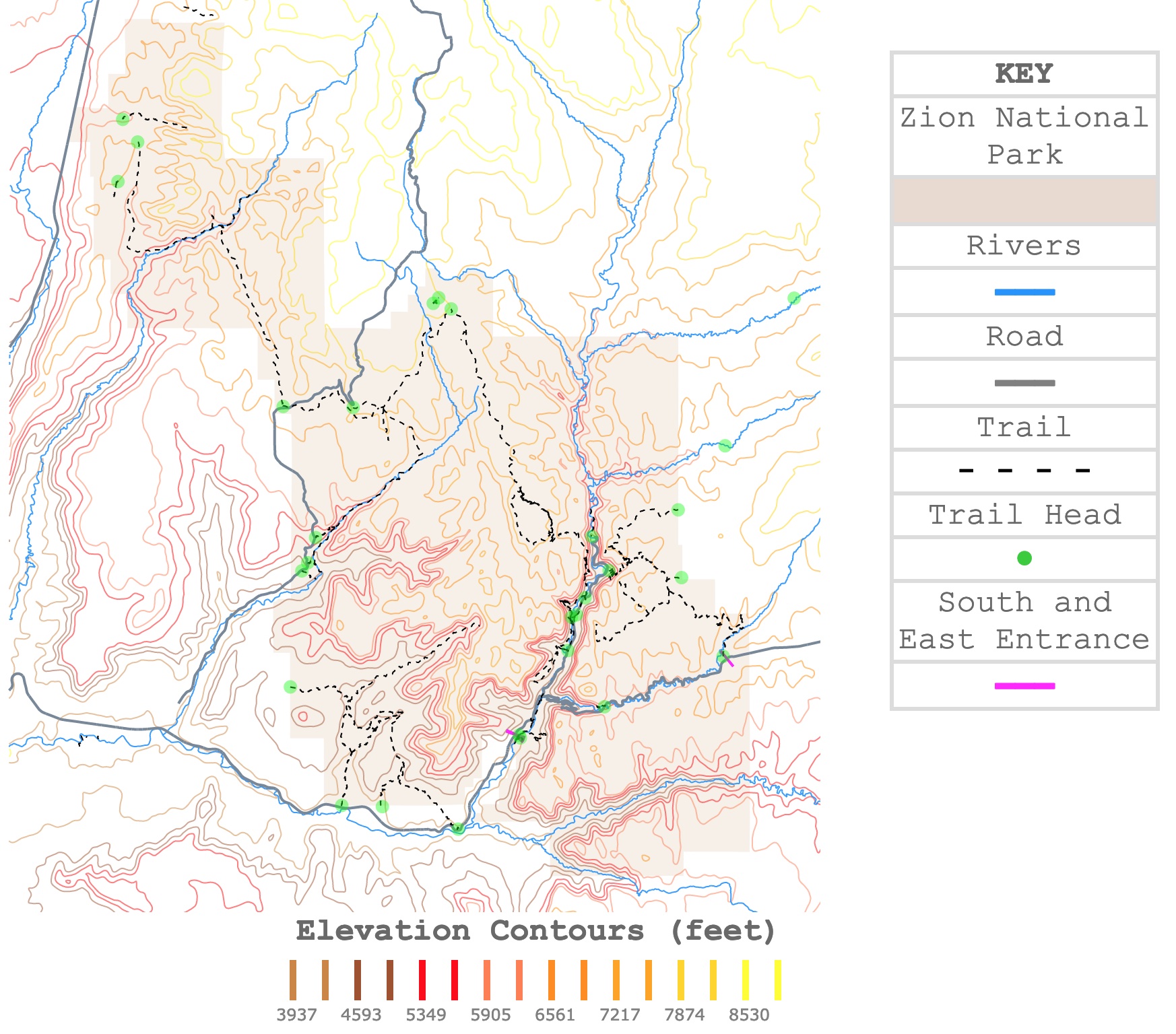
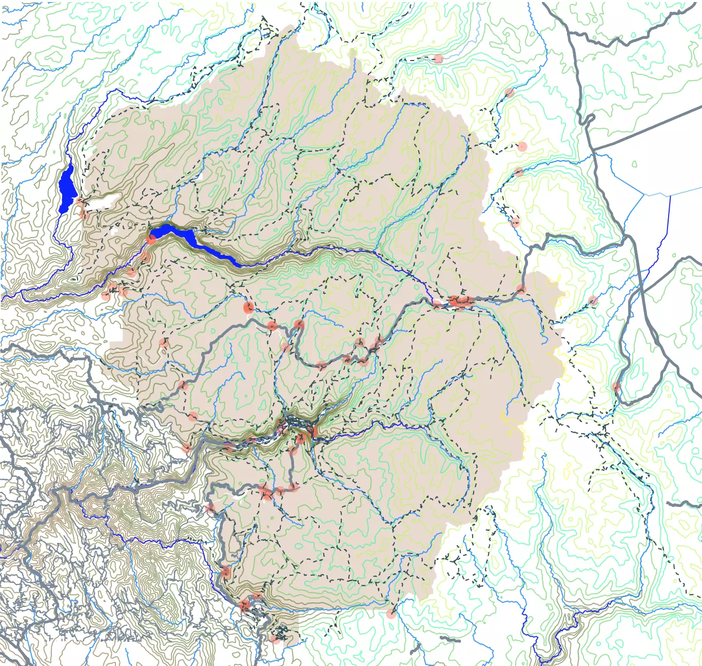
Zion National Park Elevation and Trail Map
This interactive map shows the contour lines of Zion National Park. Different colors represent different elevations. The map also indicates rivers, roads, and trails around the canyon. For more detail, zoom in. For names and facts, hover over the feature. For more information scroll down.
| KEY |
|---|
| Zion National Park |
| Rivers |
| ━━━ |
| Road |
| ━━━ |
| Trail |
| - - - - |
| Trailhead |
| ● |
| South and East Entrance |
| ━━━ |
Elevation Contours (feet)
Zion National Park
Zion was the first National Park in Utah. It was designated in 1909 and is one of the country's most popular national parks today.
Zion National Park is characterized by narrow canyons, sandstone cliffs, waterfalls, and scenic vistas. Unlike other canyons, visitors can walk on the canyon floor and look up at the rocks.
The park is known for canyoneering and wall climbing, as well as for its wildlife and bike-friendly routes.
Zion's Formation
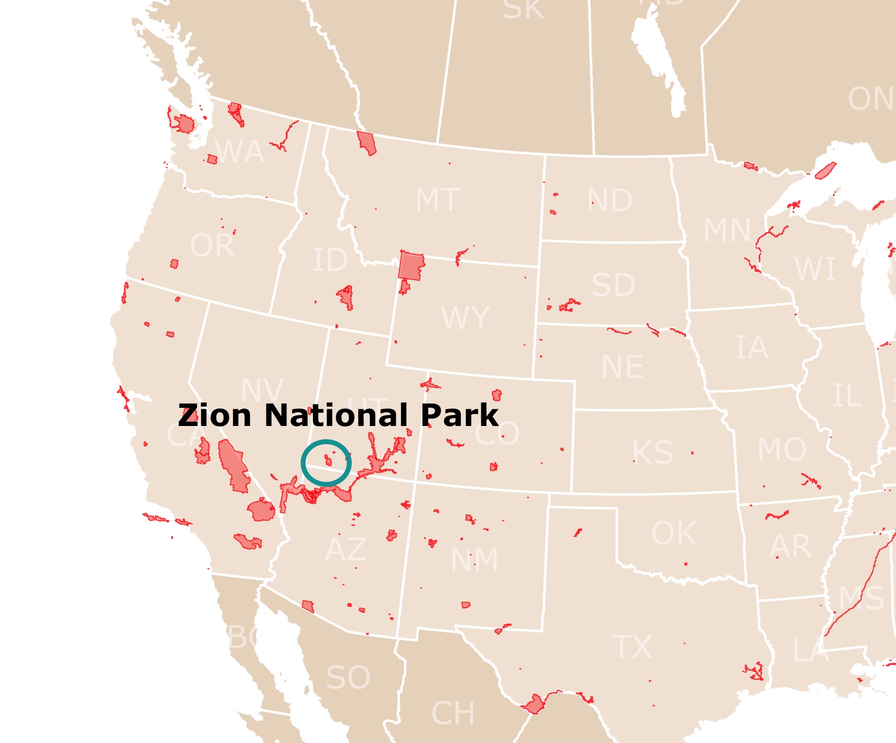
Zion National Park is situated in Utah's southwest, along the Colorado Plateau. It borders the Rocky Mountains to the east and the Basin and Range to the west.
It shares a similar geologic background to Bryce Canyon and the Grand Canyon.
Over 275 million years ago, the area's features were formed. Back then, it was a flat basin. Mud and gravel eroded from nearby mountains. This is known as the sedimentation process.
The seas flooded the area leaving carbonate deposits as well as alluvial sands. Different periods left layers of sediments.
Earth's movement resulted in uplift, folding, and deformation. Later erosional forces by the rivers formed deep and narrow canyons that we admire today.
The arid climate and lack of vegetation exposed much of the plateau, along with surface erosion, making this area one of the richest dinosaur fossil remains.
For more information about Zion National Park and its geologic wonders, Amazon has Zion National Park: The Complete Guide. It has incredible descriptions of the desert, trails, history, and the park's geology.
Zion's Climate
The park is characterized by semi-desertic conditions. Even though precipitation is deficient, it increases during winter.
During the summer, temperatures are usually over 90°F (32°C). Temperature highs may reach 115°F (46°C).
In winter, the temperature means, are around 40°F (4.4°C). Snow falls in winter, but only the high backcountry gets seriously affected, and the roads are closed. Source: American Southwest.
If you plan to hike the park during the hot summer months, it is advisable to carry water with you. Amazon has the RUPUMPACK Insulated Hydration Backpack. This is a 2.5L BPA- free, lightweight water backpack.
Map of Yellowstone National Park
Zion Roads
Vehicles are not allowed in Zion Canyon during the busy season. Visitors must use the shuttle, bike, or walk.
Between November and March, it is possible to drive through the park. Nevertheless, keep in mind that roads may close due to heavy snow.
Biking is permitted on all park roadways and only on the Pa'rus Trail.
All other park trails, off-trail routes, and the Zion-Mount Carmel Tunnel are closed to bikes.
Bicycles must ride single file on the right side of park roads and the Pa'rus Trail.
These are the roads found throughout the park. Source: NPS.
Zion Canyon Road or Zion Scenic Drive
The scenic drive is hard to miss, it is a 54-mile (87 Km) route through the canyon, and it takes about 1.5 hours to complete. This drive passes through towering cliffs on both sides. During the busy tourist season, bus shuttles make several stops for hikers and climbers to reach their destinations.
Zion Canyon Road is northbound from the South Entrance to about halfway through the park.
This is the most visited side of the park, as Angels Landing, Emerald Pools, and The Narrows are along the drive.
The easiest way to access it is by shuttle. Nevertheless, the pullouts and parking are usually packed. You might want to arrive early.
Visitors can enjoy the route on bikes and return on the shuttle buses with their bikes on racks.
Map of the Smoky Mountains National Park
The Shuttles
The shuttles are free and do not require tickets or reservations.
The shuttles run daily from March to November. From February to March, they run only on weekends.
- The Zion Canyon Line takes visitors to the park. The stops correspond to the most popular sites. These sites are the trailheads or green dots you see on the map.
- The Springdale Line transports people from the villages, lodges, and hotels outside the park in the town of Springdale to the Southern Entrance.
For hotels and prices in Springdale, check this link to Expedia. It includes amenities and dates.
Zion Mt. Carmel Scenic Highway (Hwy 9)
You may also take the Zion-Mount Carmel Highway. In contrast to the previous ride, this one has views of the top of the cliffs. For the highway, you must bring your vehicle.
Top attractions are found along the route. These include West Temple, East Temple, Court of Patriarchs, Zion Lodge, and Zion Human History Museum, among others.
Highway 9 is a 14-mile (22.5 Km) road that goes through Zion National Park and links the east side of the park and Kolob Road.
This road is open for vehicles throughout the year.
Visitors enjoy this route to experience Mt. Carmel Tunnel. The tunnel was built in the 1920s, and it is an engineering marvel.
Mt. Carmel Hwy runs along Canyon OVerlook Trail and Checkerboard Mesa.
Map of Yosemite National Park
Kolob Road
Kolob Road, also known as the Kolob Terrace Road, goes through the park's western side.
This is not as popular as other roads, but it still has incredible views from this side of the park.
There is no ranger booth to access this side of the park.
Interesting stops include Valley Trail, Wildcat Canyon Trail, and Northgate Peaks.
Kolob Canyons Road
Kolob Canyons Road is a gorgeous area of Zion. It has many trailheads and amazing rock formations with sandstone peaks and waterfalls.
Vehicles are permitted, and there is a Ranger Booth where visitors pay for access to the park.
Places of interest include Timber Creek Overlook trail, Taylor Creek Trail, and La Verkin Creek Trail. Source: Zion Roads.
Lava Point Rd and West Rim Rd
These roads are located on the northern side of the park. These roads are not paved.
Zion National Park Points of Interest
Most Points of interest are represented as trailheads and depicted with green dots on the map.
Grotto's Trail
This is the fifth stop from the Zion Canyon Shuttle.
This is a short hike; it is only a 1 mile (1.5Km) round trip.
Lots of cliffs for climbing (most are for experts), paths for hiking, sites for camping, and trails for horseback riding. Source: Zion National Park.
Do you want to see hotel and ticket prices? Check with Expedia below.
Emerald Pools
This is a short hike that also begins at the fifth stop. Marked on the map above.
The hike crosses the Virgin River several times. It leads the hikers to a lush oasis in the middle of the desert.
The Narrows
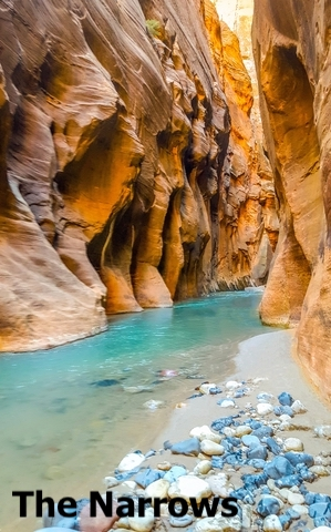
Just north of Canyon Road is the Riverside Walk trail. This is usually the starting point to reach the Narrows.
There is no trail to reach the narrows. Hikers continue from Riverside Walk hiking in the Virgin River. Hiker's feet get wet as they walk in the river.
The Narrows is a demanding hike of 9.4 miles (15Km). Most of the hike is in the river, but the views of the rocks around you are just incredible.
For hikes like this, Amazon has the ideal footwear. The Merrell Tetrex Rapid Crest Water Shoe is a Hikable, protective water shoe that features open mesh for fast dry-out times and a siped sole for traction.
Angel's Landing
Angel's Landing is a famous hike in the park. The trail is only 5.5 miles (8.8Km) long, but it reaches 1,500 feet (457m) of elevation.
This hike is not for someone with a fear of heights. There is even a narrow pass with drops on both sides. It takes about 4 to 5 hours to reach.
This trail is off Zion Canyon Rd. To find it, you must zoom on the map.
Pa'rus Trail
The Pa'rus Trail is just north of the South Entrance. It is one of the newest trails and most accessible. Because it is paved, it is accessible by bike.
The Pa'rus Trail is easy to get to, paved, flat, and gentle. It takes about 2 hours to complete.
The trail has beautiful views, wildflowers, and mule deer and borders the Virgin River. Source: Zion Guide.
Kolob Canyons
Kolob Canyons is in the northwest corner of the park. They are easily accessed though Kolob Canyons Rd.
The Timber Creek Overlook Trail follows a small ridge with amazing views of the Kolob Canyons, the Kolob Terrace, and the Pine Valley Mountains.
Follow Me
Map of Caves in the USA
Sources to Make Zion National Park Map
The contour lines from Zion National Park were downloaded from USGS
The Trail shapefiles were downloaded from NPS
The Road shapefiles were downloaded from USGS.
The shapefiles for Zion National Park were downloaded from Science Base USGS.
The River Shapefiles were downloaded from UGRC.
This map will be updated with new data! To receive updates on this and more nature maps, join my email list!!!!!!!
Made by Luz K. Molina with D3.js.