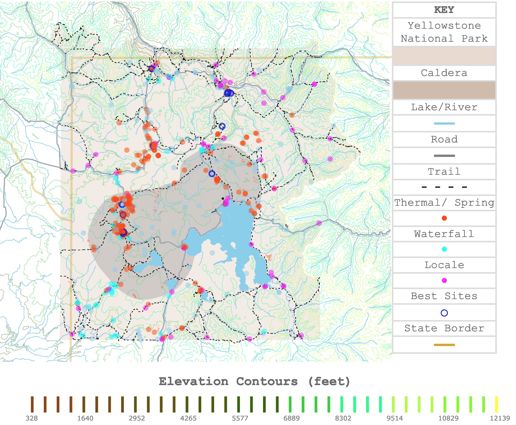
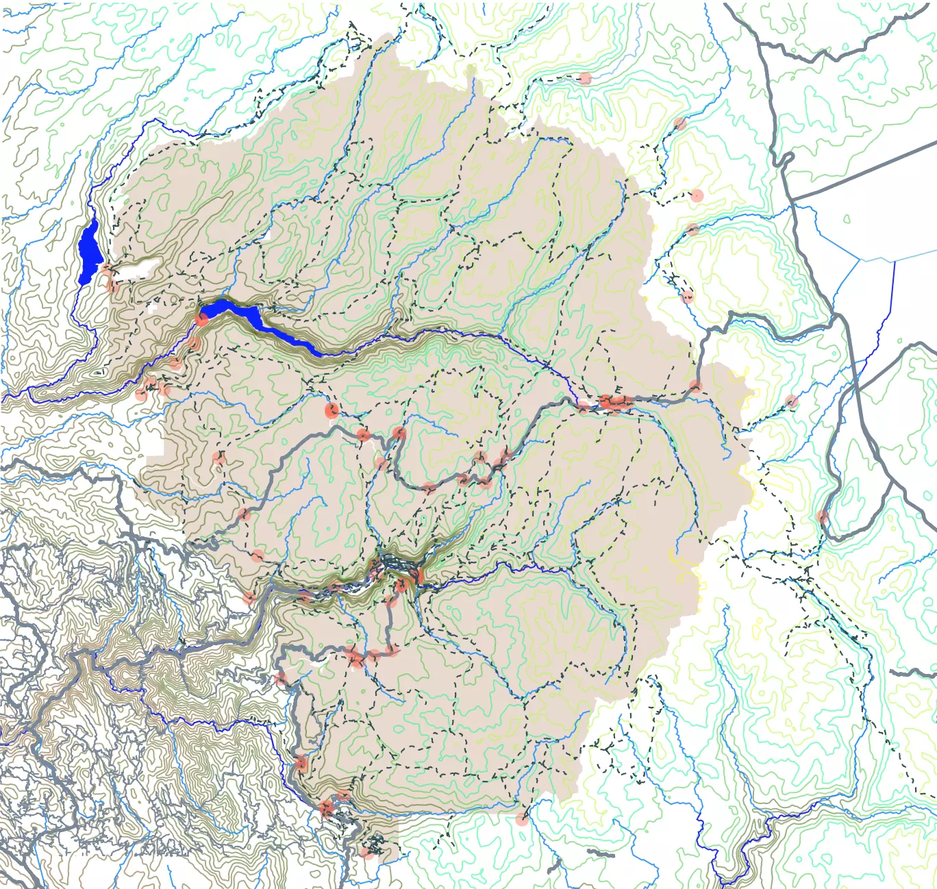
Yellowstone National Park Map
This interactive map shows the elevation contour lines of Yellowstone National Park. Dark colors represent lower elevations. The map also shows main sprints, geysers, waterfalls, rivers, roads, and trails around the park. For more detail, zoom in. For names and locations, hover over the map. For more information scroll down.
| KEY |
|---|
| Yellowstone National Park |
| Caldera |
| Lake/River |
| ━━━ |
| Road |
| ━━━ |
| Trail |
| - - - - |
| Thermal/ Spring |
| ● |
| Waterfall |
| ● |
| Locale |
| ● |
| Best Sites |
| ◯ |
| State Border |
| ━━━ |
Elevation Contours (feet)
Yellowstone National Park
Yellowstone's Location
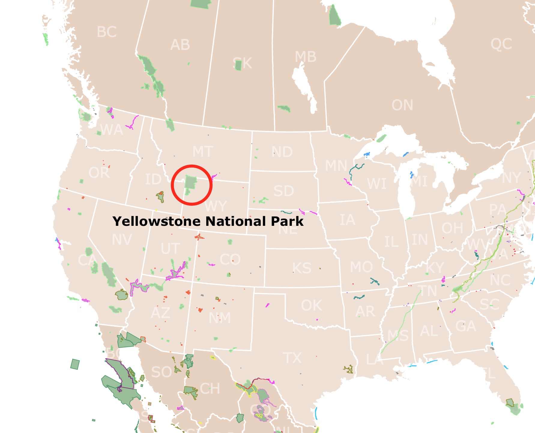
Yellowstone National Park is in the northwestern corner of Wyoming. The park is 3,472 square miles. It also covers a small area of Montana and Idaho.
Because of its large size, the park has five entrances. Depending on what you wish to visit, it is highly recommended that you choose the entrance closest to the site you want to see.
Yellowstone is not far from Grand Teton National Park, Glacier National Park, Badlands National Park, and Devils Tower National Monument. It is pretty common for visitors to go to more than one park while in the area.
If you want to learn more about the park's history, Amazon has the Yellowstone National Park: The First 150 Years hardcover book.
Yellowstone's Climate
In spring and fall, daytime temperatures range from 30°F to 60°F (0°C to 16°C). In the summer, temperatures are usually 70°F (21°C). In winter, temperatures range from 0°F to 20°F (-18°C to -7°C) during the day.
Sub-zero temperatures are common at night and in high elevations during winter. Snowfall averages of 150 inches (381 cm) a year; NPS.gov.
If you can pick the season you wish to visit Yellowstone, try to avoid the peak season in the summer months. The best months to go are April, September, and October.
In spring months, bears come out of hibernation, and migrating birds arrive. There are also great months to spot other wildlife, and the temperatures are not very cold.
Map of the Grand Canyon National Park
Yellowstone's Geography
Lakes and rivers make up about 5% of the park's area. The most prominent river is the Yellowstone River. The largest waterbody is Yellowstone Lake with 87,040 acres. The lake is 7,733 feet (2,357 m) high. This makes it the highest lake in North America.
Yellowstone Lake freezes over in winter. Its average temperature year-round is 41°F (5°C). Swimming is not recommended in the lake.
The main range that crosses the park is the Absaroka Range. It runs from Montana, along the Yellowstone River, and southeast into Wyoming.
The landscape of the park is dominated by forests and some grassland. The topography is quite varied, as shown on the map. There are also mountains and deep canyons.
Hayden Valley is the vast central grassland in the park. Because it once was compact lake bottom sediment, it does not support much forest growth. It is also a great place to observe wildlife.
Yellowstone's Geology
Many processes affect the geology of Yellowstone. The main theories behind Yellowstone's active geology explain that the North American plate is slowly moving.
This movement left Yellowstone over a hot spot. Therefore there is higher volcanic activity in the area.
The Yellowstone Caldera is the most extensive volcanic system in North America. It formed due to the volcanic activity of this hot spot, probably 630,000 years ago, during a massive eruption of the Supervolcano.
Yellowstone is on an active Supervolcano. Supervolcano implies that in the past, the system had an eruption of more than 1,000 cubic kilometers (250 cubic miles) of magma.
The area is also prone to earthquakes. Fortunately, they have not been strong in the past 60 years.
Map of Yosemite National Park
The Grand Canyon of the Yellowstone
Because of the volcanic eruptions, the Caldera was filled with lava and sediments for thousands of years. Eventually, the Yellowstone River carved out the soft rocks forming the Grand Canyon of the Yellowstone.
At some point, the canyon was a geyser basin. Nowadays, the Canyon is 20 miles (32Km) long and can reach 1200 feet (365m). Even today, the landscape is constantly changing.
Because the landscape is made of soft sedimentary rocks and more resistant volcanic rocks, the river's erosion formed waterfalls.
Today, several waterfalls that can be viewed from different outlooks by the canyon. The most famous one is the Lower Yellowstone River Falls, with an impressive 308-foot (93.8m) drop.
Another famous waterfall is Tower Fall. This fall is named after the stunning pinnacles on its sides. These falls are quite popular, and you may need to arrive early for a tranquil experience.
If you are looking for more ideas while planning your trip, Amazon has the Fodor's Compass American Guides: Yellowstone and Grand Teton National Parks. This travel guide includes budget ideas, flora, fauna, trailheads, and getaway towns.
Yellowstone's Hot Springs
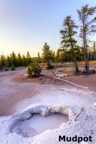
The best-known results of Yellowstone's active volcanic activity are its hot springs, mud pots, geysers, and other hydrothermal features.
It is estimated that there are over 500 scattered throughout the park. They are the most common hydrothermal features in Yellowstone.
Rainwater that seeps from the surface reaches the hot magma system underneath Yellowstone. The hot water rises in the form of hot springs.
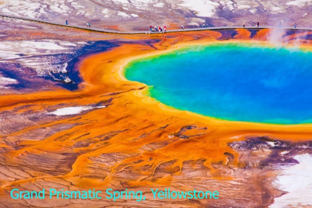
The most photographed spring is Grand Prismatic. It is larger than a football field. It has thriving microorganisms that give the springs amazing colors. This thermophile (heat-loving) bacteria give it orange, yellow, and red ring colors. The deep blue is from the spring water.
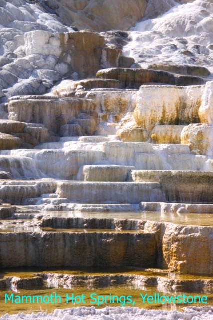
Another feature sought by tourists is the Mammoth Hot Spring Terraces. They are outside the caldera boundary, but are believed to have originated in the same system.
Here, the rising hot water dissolved the surrounding limestone creating terraces of mineral deposits. The white-like chalk material formed the beautiful travertine formations in this spring.
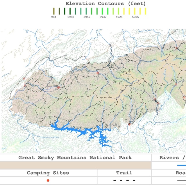
Map of the Smoky Mountains National Park
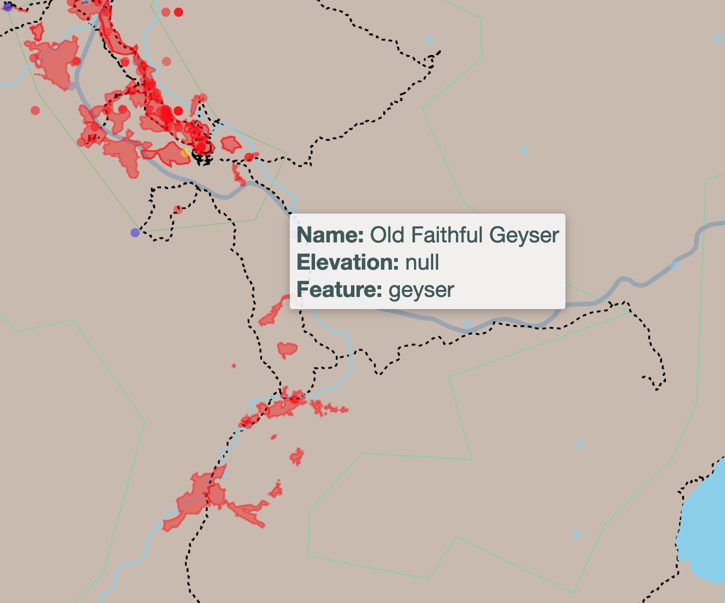
Geysers
Sometimes the boiling water can explode and shoot water into the air. This is because, near the surface, there are constrictions that prevent the water from circulating freely.
In such situations, Geysers are formed. Old Faithful is the most famous geyser. Its eruptions are easily predicted. Old Faithful geyser erupts every 35 to 120 minutes. Hence the name.
Steamboat Geyser is the largest in the world. It can reach heights of 400ft. Nevertheless its eruptions are rare.
Norris Geyser Basin is the hottest, oldest, and most dynamic thermal area. The highest temperature yet recorded in any geothermal area in Yellowstone was measured at Norris Basin. It was 459°F (237°C)!
Throughout the park, there are different geyser basins, and each one has unique features. Upper Geyser Basin is the most impressive and the most popular. Check the map for more geysers. They are inside the caldera.
Yellowstone Wildlife
Yellowstone's wildlife is diverse and abundant. The park has about 300 bird species, 16 fish species, and 67 mammal species.
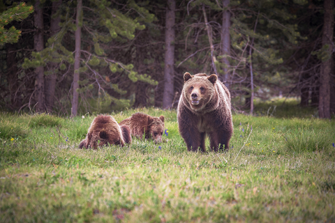
Carnivores include black bears, badgers, bobcats, Canada Lynx, coyotes, cougars, wolves, grizzly bears, red foxes, weasels, martens, wolverines, and red foxes.
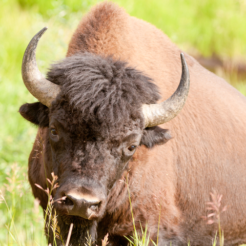
Ungulates or hooved herbivores include bison, elk, bighorn sheep, moose, mountain goat, mule deer, and pronghorn.
In the northeast corner of the park, Lamar Valley is the place to go if you wish to see populations of large animals.
Visitors can observe badgers, pronghorns, bald eagles, osprey, deer, coyotes, herds of bison, wolves, and grizzly bears.
Gray wolves were reintroduced to the park in the 1990s. Their presence resulted in a chain of events that are still helping scientists understand their role in the area's food web.
No matter what you do, make sure you don't approach wildlife.
Plant variety in Yellowstone is limited by elevation. Otherwise, it is pretty varied.
The most common plants in Yellowstone are coniferous trees like Douglas fir, Engelmann spruce, blue spruce, and whitebark pine.
As elevation increases, there are more wildflowers. Trees decrease or are shrublike. Source: Frommers.com
Map of Hot Springs in the USA
Yellowstone Trails
There are various trails that visitors can follow while visiting Yellowstone. The most popular ones are to the Grand Prismatic Hot Spring, Upper Geyser Basin and Old Faithful, Mystic Falls, Fairy Creek, and Little Firehole Loop.
The main trails lead to popular sites highlighted on the map with a red dot.
Nevertheless, one of the most iconic hikes in Yellowstone is the hike to Mount Washburn. This is a 6-mile (9.6Km) hike round-trip. It is a moderate to difficult hike, depending on your fitness level.
Once visitors reach the summit, they are rewarded with 360-degree views of the northwestern part of Yellowstone National Park, which includes Yellowstone Lake, the Grand Canyon of the Yellowstone, and the Central Plateau.
There are also wildflowers and lots of wildlife to observe while hiking this path.
For more hike ideas, Amazon has the Yellowstone National Park Day Hikes. This is a waterproof, tear-resistant map with the park's 18 best hikes.
FOLLOW ME
Yellowstone Lodging
Yellowstone has 9 lodges where visitors may spend the night. These are open from spring to fall, but only 2 are open during winter.
The park has over 12 campgrounds with established campsites. Most of them are open from June to October.
In either case, if you are lodging or camping, you must reserve in advance. Yellowstone is quite popular, so finding accommodation must be done ahead of time.
If you do not reserve ahead of time, you can always stay in different hotels close to the main gates. For Hotels, availability, and prices, check Expedia.
Sources to Make the Yellowstone Interactive Map
The contour lines from Yellowstone were downloaded from USGS.
State boundaries were downloaded from Natural Earth.
The Trails, Roads, Park Boundaries, Geothermal Areas, Caldera, Lakes, Rivers, and Points of Interest shapefiles were downloaded from Wyoming GIS Data.
This map will be updated with new data! To receive updates on this and more nature maps, join my email list!!!!!!!
Made by Luz K. Molina with D3.js.