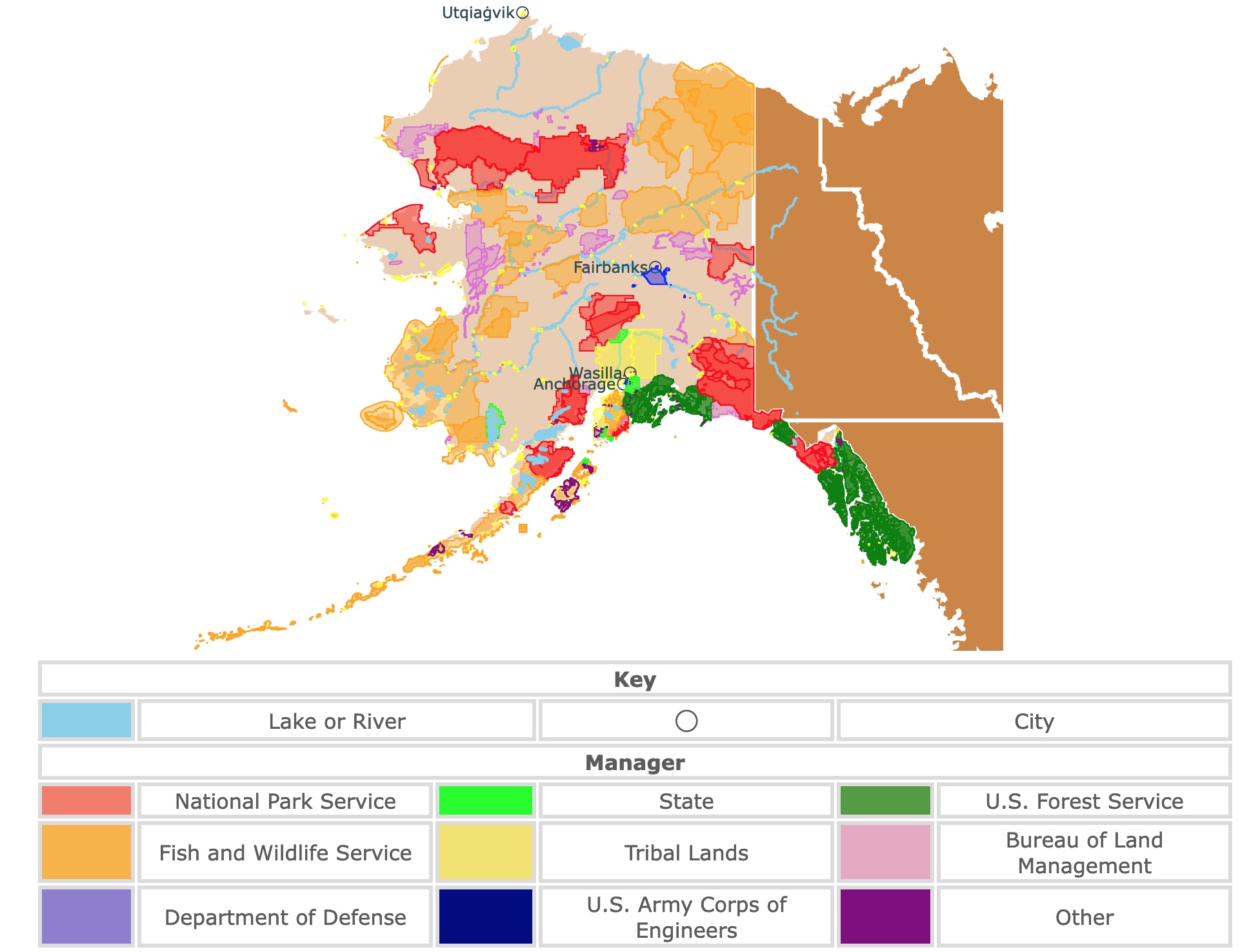
Map of Alaska's Parks and Protected Areas
This interactive map shows the Locations, Names, Areas, and Details of National Parks, State Parks, National Forests, Tribal, and other Public Lands of Alaska. It also shows major cities and rivers for context. For more detail, zoom in. For more information, hover over the map, or scroll down.
| Key | |||||
|---|---|---|---|---|---|
| Lake or River | ◯ | City | |||
| Manager | |||||
| National Park Service | State | U.S. Forest Service | |||
| Fish and Wildlife Service | Tribal Lands | Bureau of Land Management | |||
| Department of Defense | U.S. Army Corps of Engineers | Other | |||
Geography of Alaska
Alaska is thought of as "America's Last Frontier", the "Land of the Midnight Sun", and "Seward's Ice Box". All these names describe a bit of what this great state is!
Alaska is bordered by Canada's Yukon Territory to the east and British Columbia to the southeast. The Chukchi Sea and the Bering Sea lie to the west, the Arctic Ocean, and the Beaufort Sea to the north. The Gulf of Alaska and the Pacific Ocean to the south.
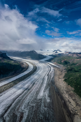
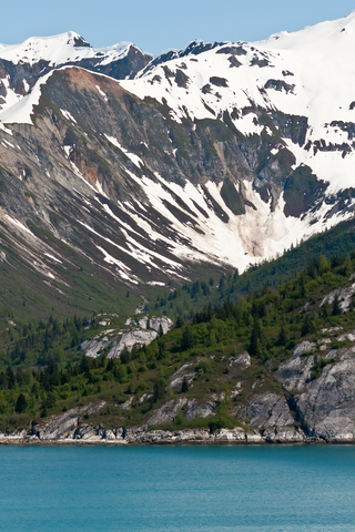
Most of Alaska is covered in a layer of permafrost or permanently frozen soil. The state is home to North America's largest glacier called "Bering Glacier". This glacier is about 2,250 square miles (5,827 square kilometers) in size (that's larger than the state of Delaware).
Alaska's western and northern coasts consist of tundra, a flat and treeless land, where bitter winds slice across the earth unseen.
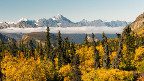
But, it's not all ice and freezing temperatures in Alaska. Denali National Park is an incredible and lush forest with views of the snow-capped Denali (also called Mount McKinley).
According to Britannica, Mount McKinley is the tallest mountain peak in North America, with an elevation of 20,310 feet (6,190 meters).
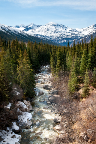
In the center of Alaska lies the Taiga Forest. It's full of evergreen trees, meadows, and lakes. Believe it or not, you can find rainforests along the southeast coast of Alaska. In fact, they are the most extensive National Forests in the U.S.
There are over 50 active volcanoes in the state. Several have erupted in recent times. The most violent eruption of the 20th century occurred in Novarupta Volcano, Alaska; USGS.
To all these superlatives, we need to add that Alaska has recorded North America's strongest earthquake. This was a 9.2 earthquake that rocked central Alaska in 1964. Alaska records, on average, 5,000 earthquakes!
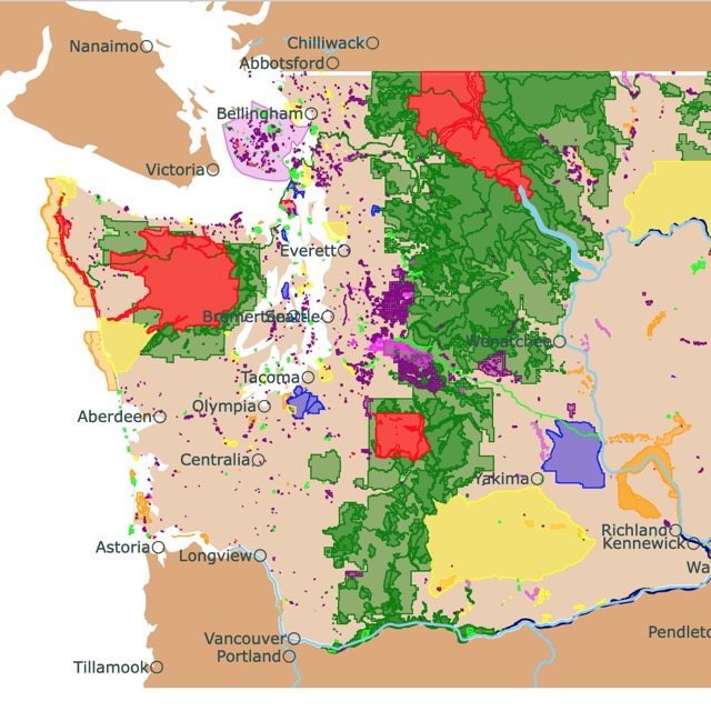
Washington state is the closest U.S. state to Alaska. To find fascinating parks in Washington, check this map
Alaska's Wildlife
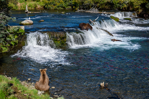
Polar bears, walruses, and beluga whales can be spotted off Alaska's west and north coasts.
Black bears, Dall sheep, moose, caribou, musk oxen, and the Kodiak bear (the world's largest brown bear) are also found on land.
Eagles, loons, and albatross can be seen flying through the Alaskan wilderness.
Sitka spruce, pine, cedar, and hemlock trees line the forests and dot the land. The forget-me-not, Alaska's state flower, is one of many beautiful wildflowers blossoming here and there.
Alaska's Climate
There are a few distinct climatic zones in Alaska. Alaska's interior experiences a continental climate. Average temperatures in this region range from 45 to 75 ℉ (7 to 24 ℃ during the summer and between 20 to -10 ℉ (-7 to -23 ℃) during the winter.
Another climatic zone exists in the islands and along the coast of the Bearing Sea. Summer temperatures average between 40 to 60 ℉ (4 to 16 ℃), and winter temps range from 9.5 to 20 ℉ (-7 to -12 ℃).
World Population Review says that Alaska is one of the coldest states in the U.S., and the average yearly snowfall measures 64.46 inches; Snowfall.
Bob Kaufman from Alaska.org says the best time to visit Alaska is during their summer season, from May 10th to September 15th. Between June 15th and July 15th is the height of prime summer conditions that are dry and warm.

If you want to learn more about the Gulf of Alaska, visit North America's Marine Ecoregions Map
Best Parks of Alaska
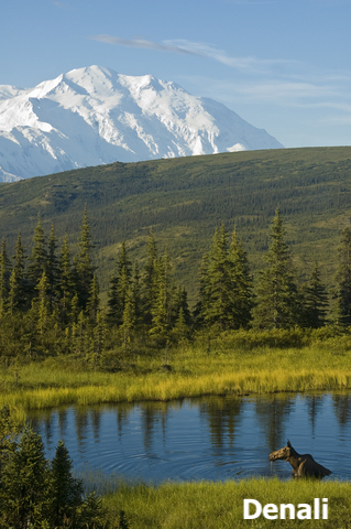
Denali National Park
Denali National Park is the red area southwest of Fairbanks.
Denali Park Road is 92 miles long and the only road in the park. This is a scenic road and the only entrance to the park, running east to west.

According to the National Park Service, park visitors can only drive 15 miles of the park road before hopping on a bus to travel the rest of the way. Denali Park has tour and transit buses that traverse the park.
Denali is exceptional because of its taiga forest, alpine tundra, and North America's tallest mountain Denali. It is also notable because of its wildlife, including Grizzly bears, caribou, and moose.
Denali Park began as a way to protect Dall sheep from overhunting back in 1917. Since then, the park has grown, now spanning around 6 million acres.
Exploring in Alaska is a bit different than in the lower states. You can visit and learn about sled dogs. Denali is the only National Park with a kennel for working sled dogs (an essential means of transportation in the area).
Camping, hiking, wildlife viewing, floating the rivers, and mountaineering are some of the adventures awaiting park visitors.
There is plenty of opportunity for some off-trail hiking in the wilds of Alaska. The park doesn't have a lodge or hotel run by the National Park Service like many parks, but Denali has six campgrounds.
Three campgrounds are open to tent and RV camping, while the other three are limited to tents only; Denali.
Wrangell-Saint Elias National Preserve
Wrangell-Saint Elias National Preserve is the red area in southeastern Alaska.
The beauty of Alaska's raw, untouched, and untamed wilderness is intense. It's like looking at a National Geographic image. This National Preserve is the largest national park in the U.S.; imagine six Yellowstone parks together!
You can follow any stream or river system to the source, which will be a glacier, whether it's an advancing, receding, or tidewater. A trip throughout this park provides a true sense of adventure.
The Wrangells are volcanic in origin, but only Mount Wrangell remains active. Mt. St. Elias, at 18,008 feet (5.5km), is the second-highest peak in the U.S.
Some outdoor recreational opportunities include day hikes, mountaineering, boating, floating, fishing, hunting, backpacking, and wildlife viewing.
Several ranger-led guided tours offer information about the park's geology, nature, history, and inhabitants. There is a kids and youth ranger program full of activities.
This protected area continues into the Yukon Territory and transforms into Canada's Kluane National Park Reserve.
Winters in Alaska may be harsh, but that doesn't stop visitors from coming out for activities. Snowmobiling, hiking, snowshoeing, and cross-country skiing are a few winter activities for those that want to brave the cold and snow.
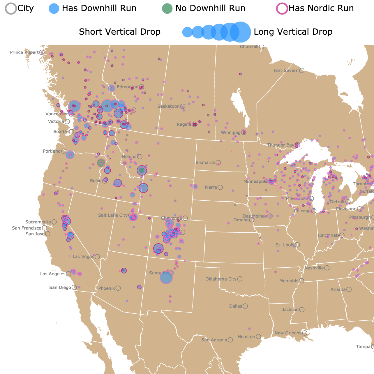
Alaska has endless locations for skiing and snowshoeing. For more details, visit this map of Ski Resorts
Kenai Fjords National Park
Kenai Fjords National Park is the red area south of Anchorage.
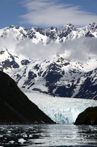
This is another incredible natural setting that looks like a scene out of a movie. Located at the edge of Kenai Peninsula is Kenai Fjords National Park, where 40 glaciers flow from the Harding Icefield to the sea.
Learn more about the park, glaciers, and the wilderness by attending a ranger-led program.
If you've ever wanted to get up close and personal to a glacier, you may check out the Exit Glacier area. There is a nature center: Short walking trails and incredible viewpoints.
Boats launch out of Seward's small boat harbor during the summer every day. This is an excellent way to explore Kenai Fjords and the wilderness.
Half-day and full-day tours are available. A full-day tour takes passengers out to the tidewater glaciers. In contrast, the half-day tour sticks to the protected waters of Ressurection Bay.
Kayaking the Kenai Fjords is a more private way to observe and witness the beauty and life of the park. For inexperienced kayakers who want the opportunity to paddle the Fjords, traveling with a guide is the safest route to take.
If you've ever wanted to camp in the rawest wilderness available in the U.S., head to Alaska. While some parks have primitive and improved sites, others offer hardcore, backcountry camping; Kenai.
Gates of the Arctic National Preserve
This National Preserve is the red area in northcentral Alaska.
You won't find any human-made trails or roads in the Gates of the Arctic National Preserve. Here lies a land where you can discover intact ecosystems where people have lived harmoniously with the land for thousands of years or more.
The wild rivers flow and rush through incredible glacier-carved valleys.
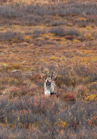
Caribou and moose migrate along seemingly ancient trails.
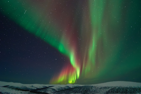
The Aurora Borealis shines brightly between August and April when the skies are darker at night because there's less daylight.
Visiting the Gates of the Arctic requires the knowledge and skills to be completely self-sufficient in the wilderness. Hikers must also have essential survival gear and equipment.
Visitors may find Grizzly and black bear, moose, wolf, Dall's sheep, wolverine, muskox, and fox.
Outdoor recreation opportunities include several rivers for floating, backpacking, hiking, birdwatching, hunting, wildlife observation, river activities, and camping. Lakesides and gravel bars provide comfortable camping options.
For those who don't have the time or backcountry survival skills, you can still fly out for a day trip or camp at neighboring parks and preserves that are less off-the-grid and remote.
Alpine Lake offers excellent fishing opportunities. The environment may be rugged, yet still, there is a softness and beauty within the serenity of the wilderness; Gates.
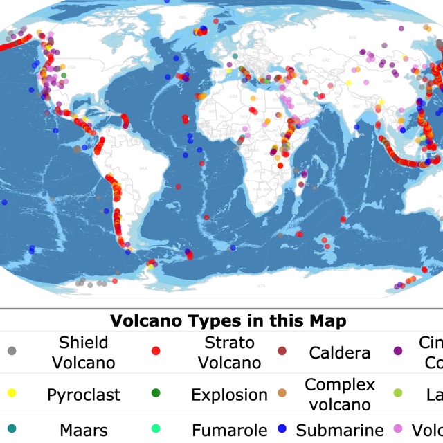
Alaska has many active volcanoes. To see where they are, visit this map
Glacier Bay Wilderness
Glacier Bay Wilderness is the red area in the southeastern strip of Alaska.
Glacier Bay preserves one of the most significant sections of the National Wilderness Preservation System. The Wilderness comprises over 2.7 million acres of land in southeast Alaska.
As a wilderness unit, this area is a sanctuary where humans exercise humility.
Bartlett Cove is the only area of the park that's developed. You'll find the Park Visitor Center, Glacier Bay Lodge, park headquarters, exhibits, a public dock, several trails, a walk-in campground, and kayak rentals.
Dwellers worth noting in the area are the salmon and humpback whales. Both are visible depending on the time of year.
Watch out for the tides. They swell and recede twice daily, with a difference of up to 20 vertical feet (6m).
Glacier Bay mainly comprises water meaning boat tours are a huge deal. Explore by kayak, tour boats, charter boats, or your boat.
According to the National Park Service, flightseeing is one of the best ways to see Glacier Bay Wilderness. Soar above the peaks and glaciers for a spectacular aerial view of the wilderness.
The Historic Glacier Bay Lodge is open during the summer season, typically from Memorial Day until Labor Day weekend. Because of the risk of bears and other large mammals, camping requires a permit. In Alaska, essential regulations must be followed for safety reasons.
Aside from Bartlette Cove and the Visitors Center, there are three different areas in the park to explore: the Outer Coast, the Community of Gustavus, and Dry Bay (Glacier Bay National Preserve); Glacier Bay
Katmai Wilderness
Katmai Wilderness is the red area southwest of Anchorage.
This Wilderness location is an excellent place to experience those up-close wildlife opportunities you've been hoping for. You will likely catch a glimpse of a bear or two. There will also be sea otters, moose, and eagles out and about.
Go on an adventure with one of the park's wilderness guides to learn about the area's history. Alaska might be cold, but there are fields of fuchsia fireweed and more than 700 species of plants thriving in the Katmai Wilderness ecosystems.
In the Valley of Ten Thousand Smokes, there is a landscape that looks like it came from the moon. It recently started to show signs of life after the devastating eruption of Novarupta in 1912.
The Katmai Wilderness Lodge provides all of the usual creature comforts that guests might forget they're surrounded by wilderness in the middle of Alaska until they look out of a window.
The lodge is eco-friendly, using wind and solar power. Supposedly, the food served from the lodge kitchen is excellent! Katmai.
Alaska has a large percentage of Worldwide Glaciers. To learn more about them, visit this map
Tongass National Forest
Tongass National Forest is the green area in the southeastern panhandle of Alaska.
According to USDA Forest Service, Tongass is the nation's most significant National Forest. Most of Southeast Alaska is comprised of the Tongass Forest.
The outdoor recreation opportunities are quite different from those at many other parks in the U.S. For instance, taking a sled-dog ride on a glacier or frozen lake.
Seeing eagles, bears, and possibly spawning salmon is common at Tongass. Enjoy a peaceful stroll along boardwalk trails, chill at a remote cabin, and capture incredible moments on film or camera.
According to USDA Forest Service, Anan Wildlife Observatory Site has one of the largest pink salmon runs in southeast Alaska. So, Anan is a place to consider stopping into for those hoping to see some salmon; Tongass.
Chugach State Park
Chugach State Park is in southcentral Alaska, east of Anchorage. The park's westernmost boundary is located in the western foothills of the Chugach Mountain Range and only seven miles east of downtown Anchorage.
The diverse landforms and rugged topography can define Southcentral Alaska. To the north and west is the Alaska Range; to the east lie Prince William Sound, Chugach, and Wrangell Mountains.
This is one of the largest state parks ib the United States, with over 495,000 acres of land.
Extensive ocean shoreline, ice fields, massive glaciers, and an abundance of lakes characterize this state region.
Biking, hiking, horseback riding, boating, snowmobile riding, and other outdoor recreational opportunities are enjoyed; Chugach.
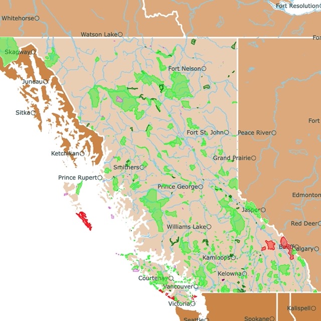
Want to find places to explore in nearby British Columbia? Check this map of British Columbia Parks
Aniakchak National Monument
Aniakchak National Monument is the second red polygon on the Alaska Peninsula.
Due to Aniakchak's remote location and the challenging weather conditions, it's one of the least visited places within the National Park System.
The landscape is a visual reminder of Alaska's location in the "Ring of Fire". According to the Smithsonian Institution, the last known eruption of this volcano was in 1931.
Aniakchak is home to a six-mile wide, 2,500-foot (762 meters) deep caldera formed by a massive volcanic eruption more than 3-thousand years ago. However, visitors still come to backpack, hike, and paddle in the area.
The Aniakchak River is a national wild river; therefore, it is possible to raft from the volcano to the ocean! This is a challenging river reserved for experts but still perfect for an adventure Aniakchak.
Lake Clark National Park
Lake Clark National Park is the red area west of Anchorage.
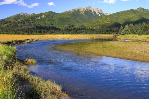
Imagine craggy mountains reflected in the turquoise lakes, volcano steam spouting up every now and again, salmon running, bears doing bear things, and Lake Clark.
Visitors can enjoy a day on Lake Clark's coastline, take a trip to Crescent Lake, backpack, adventure, and explore the park's hidden gems and treasures. There aren't any roads leading to this park, so you'll have to plan and schedule a trip by boat or plane.
This is also the world's largest sockeye salmon fishery in the world! Therefore, an important part of the ecosystem and local communities; Lake Clark.
Affiliate Disclosure
Databayou.com is a participant in the Amazon Services LLC Associates Program, an affiliate advertising program designed to provide a means for sites to earn advertising fees by advertising and linking to Amazon.com. Databayou.com also participates in affiliate programs with Clickbank, CJ, and other sites.
If you plan on visiting one of these remote parks or hiking up Denali, I suggest you get some of these items found on Amazon.
- Fishing Shelter: This is a portable fishing shelter, providing a larger area than most shelters.
- Mountaineering Sleeping Bag: This mummy sleeping bag is perfect for extreme weather under -20 degrees. It has a highly durable polyester ripstop fabric paired with an inner polyester lining.
- Victorinox Swiss Army Huntsman Pocket Knife (Red): An army knife always comes in handy. You never know what you will find or need in remote areas.
FOLLOW ME
Resources for Alaska's Protected Areas Map
The shapefiles with Alaska's state boundary lines, lakes, major rivers, and cities were downloaded from Natural Earth Data.
The Parks and Public Lands shapefiles for Alaska were downloaded from USGS.
This map will be updated with new data! To receive updates on this and more nature maps join my email list!!!!!!!
Made by Luz K. Molina with D3.js.