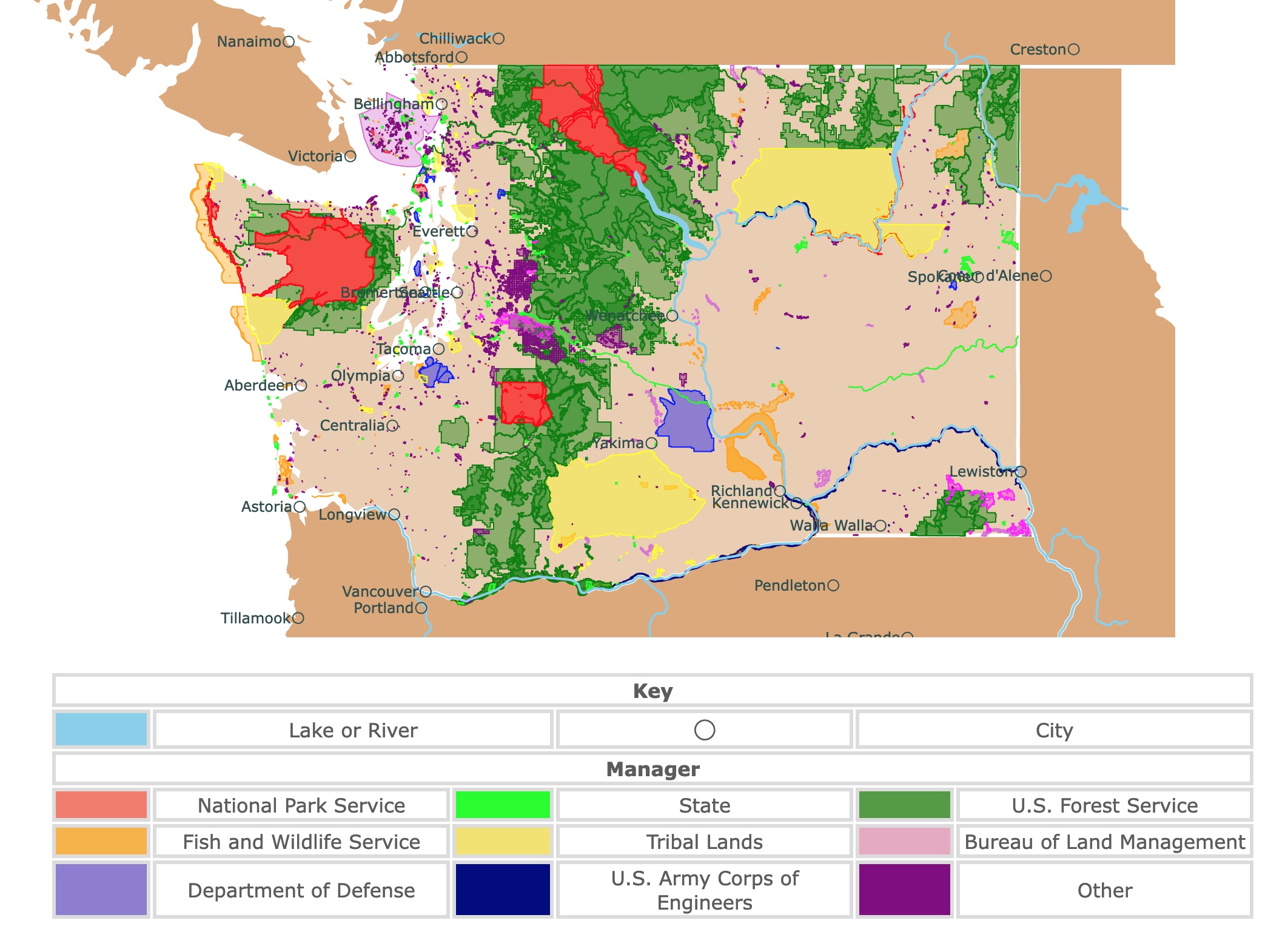
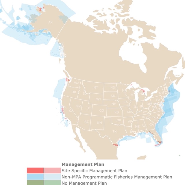
Map of Washington State Parks and Protected Areas
This interactive map shows the Locations, Names, Areas, and Details of National Parks, State Parks, National Forests, Tribal, and other Public Lands of Washington. It also shows major cities and rivers for context. For more detail, zoom in. For more information, hover over the map, or scroll down.
| Key | |||||
|---|---|---|---|---|---|
| Lake or River | ◯ | City | |||
| Manager | |||||
| National Park Service | State | U.S. Forest Service | |||
| Fish and Wildlife Service | Tribal Lands | Bureau of Land Management | |||
| Department of Defense | U.S. Army Corps of Engineers | Other | |||
Washington State Geography
Washington State's geography is spectacular and diverse around every bend. There are seven incredibly distinct physiographic regions, from the beautiful volcanic peaks of the cascades to the fertile fields of the Columbia Basin.
Washingon is bordered to the north by Canada's British Columbia, to the east with Idaho, to the south with Oregon, and to the west with the Pacific Ocean.
Washington state is divided by the beautiful Cascade Mountains - Eastern Washington and Western Washington.
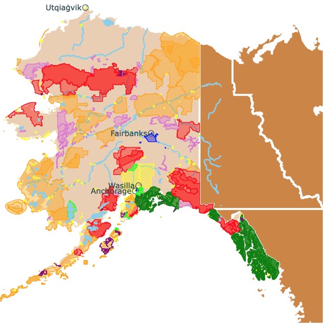
Want to find places to explore in Alaska? Check this map of Alaska Parks
Western Washington
Western Washington is the most densely populated region between the two. According to the U.S. Census Bureau, over half of the population lives in the western region.
During the last ice age, glaciers carved their way across the land. Western Washington is hilly and mountainous, with several lakes and rivers, including the three major lakes that dictate the geography of the greater Seattle region. The lakes are; Washington, Sammamish, and Lakes Union.
The glacial activity that carved the mountains created the many islands dotting the Strait of Juan de Fuca and Puget Sound. The result is a stunning landscape that's ever-changing and breathtaking.
Western Washington's weather is relatively mild, with summer days rarely peaking over 79°F (26°C). Winter daytime temperatures rarely drop below 45°F (8°C). While snowfall is rare, the nighttime winter temperatures can quickly fall into the 20s and 30s (-6°C to -1°C).
The Pacific Ocean forms a marine layer where the clouds are frequent during the autumn, winter, and spring. But, several days of constant rain is the exception. July and August are the driest months, with January and February being the wettest.
Incredible mountains surround the area; the Olympic range to the west, Mt. Baker to the north, the Cascade range to the east, and the majestic Mt. Rainier to the south. Mt. Rainier is one of the tallest peaks in the continental U.S.
Eastern Washington
The Pacific Ocean and the Olympic Mountains influence Western Washington. The Cascade range affects the climate and weather on the state's eastern side. The Cascades capture most of the rain that would otherwise fall onto Eastern Washington.
The mountains can receive up to 200 inches (508 cm) of snowfall yearly. In the Cascades shadow, little rain falls, and cities like Ellensburg and Wenatchee get to enjoy up to 300 days of beautiful sunshine every year. The annual amount of rainfall is far less in Eastern Washington compared to the western side of the state.
The summer months are much hotter and winters much colder compared to western Washington. Average summer highs range between the upper 80s to mid-90s (27°C to 34°C) and the winter average in the daytime range from the upper 30s to just above 0°F (3°C to -17°C).
When it comes to geography, Central Washington is very plains-like, which gives way to stunning rolling hills as you travel eastward. The rich volcanic soil and dry weather create an ecosystem that's ideal for agriculture and farming. There are over 300 crops grown in Eastern Washington.
The Columbia Gorge rises up to 3,000 feet (76.2 m) from the Columbia River, adding even more natural beauty to the eastern part of the state. What's even more incredible is the river's hydroelectric dam provides renewable and low-cost energy to businesses throughout the state.
If you're into wildlife, you're bound to see some incredible animals in Washington. From the Olympic marmot to Oregon spotted frog. There is also willow goldfinch, chorus frog, steelhead trout, green darner, dragonfly, and orcas. No worries, there are plenty of other forms of wildlife to behold.
Best National Parks in Washington
There are three national parks located in Washington, as well as several historic sites and federally managed areas. The most iconic national park in Washington is Mount Rainier which is easily accessible from Seattle, and it's family-friendly!
For these and more parks found on the list, Amazon has Washington Bucket List: Set Off on 150 Epic Adventures and Discover Incredible Destinations to Live Out Your Dreams While Creating Unforgettable Memories that Will Last a Lifetime. This book has 50 of the most incredible and exciting Washington destinations for daring adventure seekers — According to the most experienced tour guides!
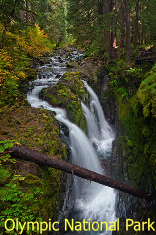
Olympic National Park
The Olympic National Park is represented in red is also the Daniel J. Evans Wilderness, located west of Seattle.
Olympic National Park has been a place of interest since the early 1800s. The park offers a wide range of attractions, from the beautiful Hoh Rain Forest to Hurricane Ridge.
The park's distinct ecosystems, including glacier-capped mountains, temperate rain forests, and over 70 miles of wild coastline, attract hundreds of visitors every year.
Beauty is abundant in the area, considering the stunning waterfalls, fantastic night skies, and calm tide pools; it's no surprise people love it.
Many people visit the park because of the Hoh Rainforest. While it isn't a tropical rainforest, it's still a rainforest nonetheless. The ecosystem stands apart from the rest of the state, making it a point of interest for sightseers and travelers.
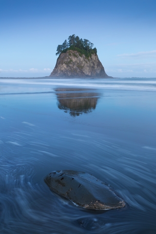
Kalaloch and Ruby Beach are popular locations. Kalaloch is said to be one of the most visited areas of the Olympic National Park. The offshore island and marine environment are highly protected by three wildlife refuges.
The best time of year to visit this outstanding national park is spring through fall. The sightseeing offers beautiful scenery and wildlife. The weather is gorgeous, and the trip is worth taking.
The history and culture of the Olympic National Park are rich with roots leading back to the indigenous peoples of the area.
Popular dwellers of the park include Roosevelt Elk, mountain lions, black bears, sea otters, gray whales, and bald eagles. The park also has the most extensive runs of wild salmon, trout, and char remaining in the Pacific Northwest.
Because of the abundant rain, the park has mosses, lichens, and ferns growing on other plants. Common trees include the western hemlock, conifers, and Sitka spruce.
EXPEDIA has amazing hotels and packages to visit Olympic NP. For more information CLICK HERE!
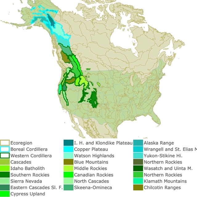
Mountains play a crucial role in Washington State's landscape. To learn more, check this map of the Northwestern Mountains
Mount Rainier National Park
Mount Rainier National Park is located southeast of Seattle and is shown in red on the map above. It has been a National Park since 1899 because of its unique beauty, thanks to John Muir, a famous naturalist, and preservationist, along with Bailey Willis, a United States Geological Survey worker.
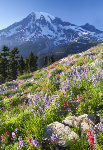
Mount Rainier is famous for many reasons. It stands out because it's the most glaciated peak in the United States. It's the highest mountain in the northwest Cascade Range with 25 named glaciers adorning the beautiful mountain.
Hikers love following the glacier peak that spans from the White River Valley to the summit of Mount Rainier. The glaciers feed water into six ice-cold rivers, including the Carbon and Mowich Rivers.
Mount Rainier is a stratovolcano that has the potential to erupt again. The steep cone shape of the mountain was formed by lava flow and ash clouds. The last eruption was around the late 1800s, which was only a tiny summit explosion.
July through August is the best time to visit Mount Rainier. The beautiful wildflowers completely transform the park's subalpine meadows. The summer provides dry, warm weather providing hikers with the prime conditions to enjoy a hike.
If you're one that would enjoy seeing the winter wonderland in action, you might want to take a trip between November and March. While the park is open all year long, during the winter, many areas are closed, including the roads!
For an unforgetable time at Mt. Rainier, VRBO has a selection of rentals for you. For dates and ammenities GO HERE!
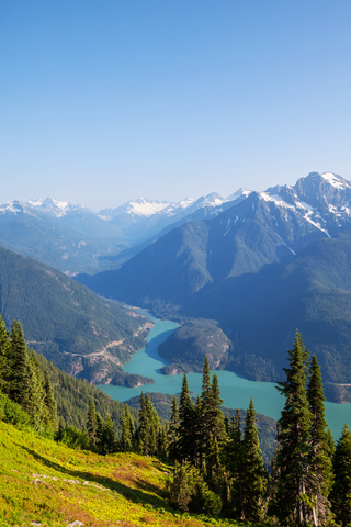
North Cascades National Park
North Cascades National Park is represented in red on the map and is also part of the Stephen Mather Wilderness. The park is located in the center of the state. North Cascades National Park is only about three hours away from Seattle.
The North Cascade Mountains are a part of the Cascade Range. The mountains run along the border between the state of Washington and the Canadian Province of British Columbia, so they are shared by the U.S. and Canada.
According to the National Park Service or NPS, the Cascade Mountains were formed in an exciting way. Studies of rock magnetism and studies show that the terranes of the Cascades were actually formed in the Pacific Ocean.
The terranes were attached to these oceanic plates that slowly drifted northward until they collided with North America and merged together around 90-million years ago. Even today, the mountains are forming, changing, and growing due to regular geological activity.
The glacial waters, rugged peaks, and woodlands draw in a crowd. The park has an alpine landscape with over 300 glaciers; it is called the "American Alps"!
Wildlife is popular with animal and nature lovers. There are over 70 different species of mammals, a little over 20 reptile and amphibian species. Birdwatchers love the diversity of over 200 different species of birds.
The park is popular with hikers that want to visit the peaks. Still, there are countless other outdoor activities to enjoy in the park, including biking, backpacking, boating, fishing, and so much more.
If you prefer roughing it, you can camp at one of the park's boat-in-campsites. However, if you're more into creature comforts, the North Cascades Lodge at Stehekin might be more your style. The lodge provides basic accommodations, but the view is what it's all about.
Popular State Parks in Washington State
Moran State Park
Moran State Park is an Island that borders Canada, halfway between Victoria and Bellingham. The State Park is represented in lime green on the map above.
This public recreation area is in Orcas Island, located in Puget Sound's of the San Juan Islands, in the United States.
Moran State Park is a vast area encompassing more than 5-thousand acres of various terrain. You'll find hills, lakes, bogs, forests, and wetlands brimming with plants and wildlife.
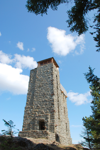
The park offers a variety of events and activities. For example, visitors can climb the stone tower at Mt. Constitution, offering breathtaking panoramas of the Islands.
With five lakes to choose from, visitors have options about where to swim, kayak, paddleboard, or fish for beautiful rainbow trout.
History lovers will appreciate the rich history and can go explore the structures built during the Great Depression by the Civilian Conservation Corps.
Moran State Park officially opened in 1921 when the former Seattle Mayor, Robert Moran, decided to donate over 2,500 acres of land to the state of Washington. The inspiration to do this came from the Great Depression. Building the park brought work to people who truly needed it.

If you want to learn more about the Pacific Coast, visit North America's Marine Ecoregions Map
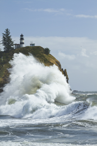
Cape Disappointment State Park
Cape Disappointment State Park is located by the Pacific Ocean, along the Oregon State border. It's represented in lime green on the map.
Cape Disappointment is a state park that pays tribute to the various uses of the area. For instance, the military outposts used during the Civil War, as well as World War II and the iconic lighthouses.
Tourists can enjoy a beautiful hike through an old-growth forest, a walk around the freshwater lakes, explore the saltwater marshes, and visit the tidelands.
There is so much to do in this stunning park. Whether you enjoy history, nature, or both, it's worth a trip.
Washington State's Public Lands
Mount Saint Helens National Volcanic Monument
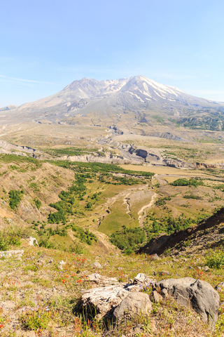
Mount Saint Helens National Volcanic Monument is located east of Astoria. It is represented in dark green on the map above.
Mount St. Helens National Volcanic Monument is located within the Gifford Pinchot National Forest, in Lewis County, southern Washington. This incredible monument was created in 1982 for research, education, and recreation.
Many people enjoy seasonal activities like fishing, hiking, snow sports, ranger-led educational programs. Some obtain the required permit to hike above 4,800 feet (1,463 meters). With such a permit, explorers can climb to the volcano's summit.
The Johnston Ridge Observatory, open seasonally, is located on Johnston Ridge in the middle of the 1980 blast zone. The observatory is only 5 miles (8km) of Mount St. Helens National Volcanic Monument.
Washington State has beautiful shorelines worth protecting. To discover more, check this map of Marine Protected Areas
San Juan Islands National Monument
The San Juan Islands are close to the border near Canada. The islands are halfway between Victoria and Bellingham. This monument is represented in purple on the map.
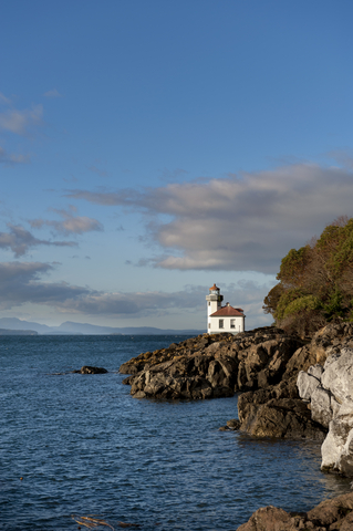
These islands are of a submerged mountain chain in upper Puget Sound near the Canadian border. San Juan Islands
This National Monument is located in the Salish Sea. If you're into science and history, you might want to check this place out. Nature lovers will appreciate the fact that it's a wildlife refuge.
The San Juan Islands didn't become a monument until 2013 when Barack Obama signed the proclamation designating the islands to be considered as a monument. The goal was to provide protection and care for the historical and cultural significance held there.
There are over 450 islands, pinnacles, and rocks that make up the islands. It's pure beauty to witness. The forests seem to pop out of gray rocks, and the distant snow-capped peaks create a stunning backdrop for the beautiful sandy beaches; it's almost as if you're in three different regions at once.
FOLLOW ME
Resources for Washington's Protected Areas Map
The shapefiles with Washington's state boundary lines, lakes, major rivers, and cities were downloaded from Natural Earth Data.
The Parks and Public Lands shapefiles for Washington were downloaded from USGS.
This map will be updated with new data! To receive updates on this and more nature maps join my email list!!!!!!!
Made by Luz K. Molina with D3.js.