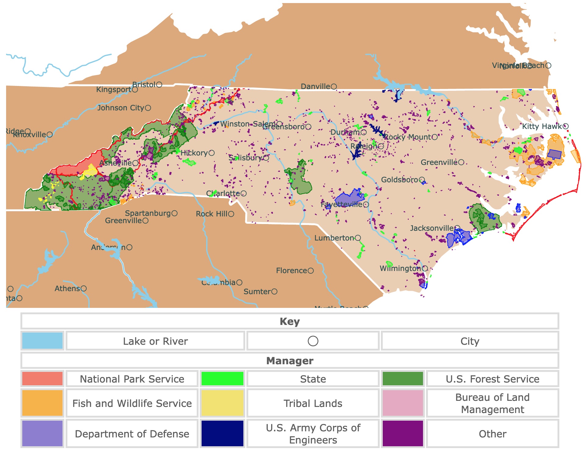
Map of North Carolina's Parks and Protected Areas
This interactive map shows the Locations, Names, Areas, and Details of National Parks, State Parks, National Forests, Tribal, and other Public Lands of North Carolina. It also shows major cities and rivers for context. For more detail, zoom in. For more information, hover over the map, or scroll down.
| Key | |||||
|---|---|---|---|---|---|
| Lake or River | ◯ | City | |||
| Manager | |||||
| National Park Service | State | U.S. Forest Service | |||
| Fish and Wildlife Service | Tribal Lands | Bureau of Land Management | |||
| Department of Defense | U.S. Army Corps of Engineers | Other | |||
North Carolina's Geography
North Carolina is the widest state east of the Mississippi River. The state is bordered by Tennessee on the west, the Atlantic Ocean on the east, Virginia on the north, and South Carolina and Georgia on the south.
North Carolina is divided into three geographic areas: Piedmont in the center, the Coastal Plain in the east, and Mountains in the west.
Piedmont is the French word meaning "foot of the mountain". The piedmont region is also called the "foothills".
The rolling hills in this region range from 300 feet (91.44 meters) in the east up to 1,500 feet (457 meters) to the west near the mountains.
North Carolina's Coastal Plain consists of low, flat land across the eastern region. Spanning from the Inner Coastal Plain's sandy farmland to the Outer Banks.
The Coastal Plain has beaches, swamps, and longleaf pines.
A string of barrier islands is separated from the mainland by inlets or sounds. The Outer Banks consist of three capes; Cape Lookout, Cape Hatteras, and Cape Fear.
The impressive landscape of western North Carolina features the Great Smoky Mountains and the Blue Ridge Mountains, which make up the Appalachian Mountains.
The Appalachian Mountains is the most extensive mountain range in the United States.
Mount Mitchell also calls this region home. Mount Mitchel rises 6,684 feet (2,000m) above sea level, making it the tallest peak east of the Mississippi.
The Eastern Continental Divide runs across the top of the Blue Ridge Mountains. It separates the rivers flowing east from those that flow west.
The rivers on the eastern side of the divide flow toward the Atlantic Ocean, while rivers on the west flow towards the Ohio and Tennessee rivers and into the Gulf of Mexico.
Want to find places to explore in nearby Virginia? Check this map of Virginia Parks
North Carolina's Climate
North Carolina is located in a warm temperate zone; however, the diverse regions experience various weather conditions. Locations in and around the mountains experience average temperatures of 30°F (-1.11°C) during January and 65°F (18.33°C) during August.
While areas within the coastal plains experience average temperatures around the mid-40s (-4°C) in January and up into the 90s (32°C) during August.
Spring, summer, and autumn are the best times to visit North Carolina for outdoor recreation.
North Carolina's Wildlife
Mammals, including coyotes, black bears, and raccoons, find their home in North Carolina.
Sea turtles are one of the exciting reptiles you might find on North Carolina's Coast. Salamanders and various amphibians can be found throughout the state.
Looking to the sky, you might find cardinals and ospreys.
The wildlife in North Carolina is captivating. From the whales and dolphins in the ocean to the woodland creatures like squirrels and rabbits, animal lovers will not be disappointed.
North Carolina has at least 300 species of trees, including shortleaf pine, longleaf pine, and American chestnut trees.
With nearly 3,000 flowering plants growing throughout the state, the landscapes are colorful, NCpedia.
North Carolina's Outer Banks are an excellent place to explore. The islands with beaches, state parks, and shipwreck-diving sites are always welcoming to visitors.

North Carolina has fantastic Temperate Broadleaf Forests. To learn more, visit this map
North Carolina's Greatest Parks and Natural Areas
Appalachian National Scenic Trail
The Appalachian National Scenic Trail is the red band on the border with Tennessee.
This primitive hiking trail runs from Maine to Georgia, with 300 miles spanning through North Carolina. This is one of the most popular outdoor destinations in the state. Long-distance hikers love the Appalachian Trail for many reasons, one being the beauty.
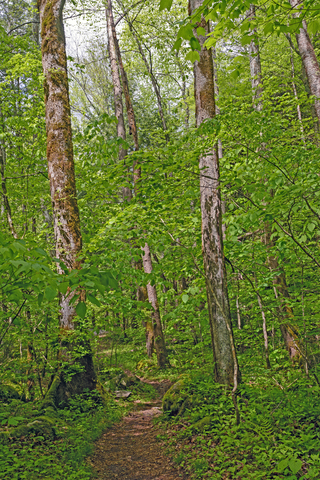
This trail is over 2,180 miles long and provides a public path crossing scenic, pastoral, wooded, and the culturally vibrant lands of the Appalachian Mountains.
Visitors do not have to be long-distance hikers to enjoy the trails. Trekkers may start and finish wherever they want.
The Appalachian National Scenic Trail passes through some significant areas throughout each state. One of the favorite areas people like to check out along the trail is Ashville.
Asheville, North Carolina, is full of attractions and things to do, including indoor and outdoor activities. From history and architecture to wild and natural areas.
Fortunately Ashvielle has lots of stays for travelers to enjoy. You can pick and choose from hotels to resorts. For flights, cars, and reservations go to Expedia!
Travelers will find zip lines, theaters, restaurants, and a wealth of wildlife; Asheville
Many of the trails pass through exciting areas rich with history and culture.
There are plenty of excellent hiking trails to enjoy.
- Max Patch has a grassy summit with incredible panoramic views.
- Roan Mountain is beautifully white in winter and full of flowers in summer.
- The Great Smoky Mountains has a lush forest and a rocky cliff with incredible views.
- Hot Springs crosses the town with the same name and a river.
- Nantahala National Forests: has plenty of lookouts!
- Fontana Dam goes across the tallest dam in eastern North America into the Great Smoky Mountains National Park.
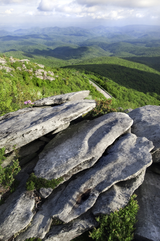
Blue Ridge Parkway
Blue Ridge Parkway is the red band east of Ashville.
The Blue Ridge Parkway reveals close-up views of the rugged mountains and calming landscapes of the Appalachian Highlands.
The Parkway spans 469 miles and protects animals and plants' diversity while driving at a slow 45mph or less.
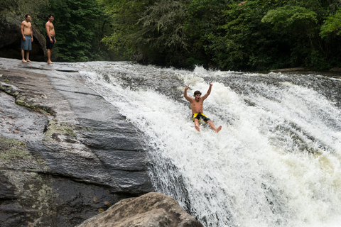
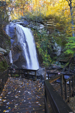
One of the most photographed waterfalls in the state is Linville Falls, situated inside the Parkway!
There are five campgrounds on the North Carolina side of the park and three on the Virginia side. Choose a campsite by a lake, or waterfall, or nestled in the forest by the mountains.
Blue Ridge Parkway offers about 300 miles of hiking and wildlife observation trails. There are several popular routes to enjoy, each one offering incredible sites with different skill levels and lengths.
The Blue Ridge Music Center is the hot spot for those who like traditional Appalachian bluegrass, string bands, and ballad singers. The Center hosts various events throughout the year.
Ranger-led programs, vehicle tours, hiking, fishing, bicycling, and photography are a few things to check out while visiting the park.
The park's history is rich. The Blue Ridge Parkway Digital Archive allows you to get a glimpse of the past through photos, historical maps, and drawings; Blue Ridge.
Expedia has different options for you to spend a tranquil escape near the Blue Ridge Parkway. For suites, cabins, cottages, and even wineries go to this link!
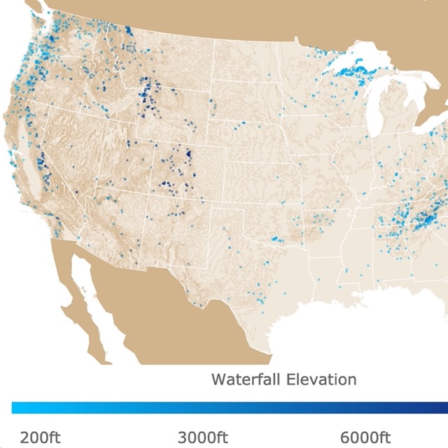
North Carolina has beautifull falls. To find more, visit this map
Stone Mountain State Park
Stone Mountain State Park is the lime green area northwest of Winston-Salem.
The colossal granite dome stands overlooking the park and stands at 600ft (182m) high over the ground.
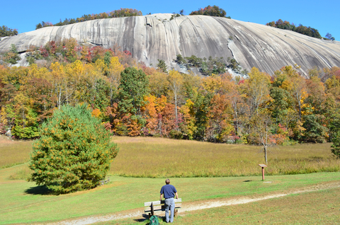
The dome is the perfect setting for visitors to enjoy various outdoor activities, including camping, hiking, fishing, climbing, horseback riding, and bird watching.
Over 18 miles of trails and more than 20 miles of trout waters are designated in the park.
A campground with 90 campsites is available; some have utility hookups.
Hutchinson Homestead, a restored mid-19th-century mountain farm, is perfect for history lovers. At the same time picnic grounds are available for large groups, Stone Mountain.
This area has idyllic views of the mountains, wineries, and golf courses! For a cozy log cabin near Stone Mountain visit VRBO!
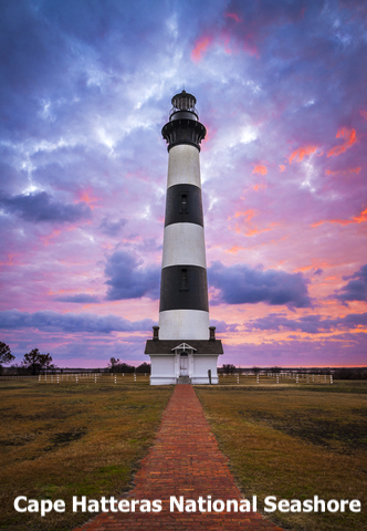
Cape Hatteras National Seashore
Cape Hatteras National Seashore is the red stripe of islands on the Atlantic Coast. These are a long chain of barrier islands known as the Outer Banks.
Ocean waves, beautiful beaches, salt marshes, and more await visitors at Cape Hatteras. Visitors come to kayak, swim, and climb the Cape Hatteras Lighthouse.
The best asset of Cape Hatteras is its beaches. Besides playing in the sand and basking in the sun, visitors can fly kites or walk for 70 miles along the Atlantic Ocean Coast. Just be aware that vehicles are permitted in certain sections.
There are three designated hiking trails throughout Cape Hatteras: the Buxton Woods Trail (3/4 mile loop), Open Ponds Trail (4.5 miles one way - 9 round trip), and the Hammock Hills Trail (3/4; mile loop).
Three historic lighthouses can be found at the park.
- The Bodie Island Lighthouse is open seasonally, and it's perfect for self-guided climbs and its full moon tours.
- The Cape Hatteras Lighthouse.
- Ocracoke Island Lighthouse isn't open for climbing, but the base can be visited for viewing periodically.
Cape Hatteras has excellent fishing opportunities from the beach, from the piers, from boats, from freshwater ponds, from the sound, or offshore!
Cape Hatteras has 5 species of turtles found on the cape's waters. But loggerhead, green, leatherback, and Kemp's ridley turtles may lay eggs on its beaches.
Seals, dolphins, and whales are not a rare sighting from the cape shores. While beach birds are in the hundreds.
The park has campgrounds for tents, RVs, and trailers near the ocean for visitors that wish to prolong their stay! Cape Hatteras.
You can stay near Cape Hatteras in an array of inns and stays. For details and amenities visit Hotels.com.
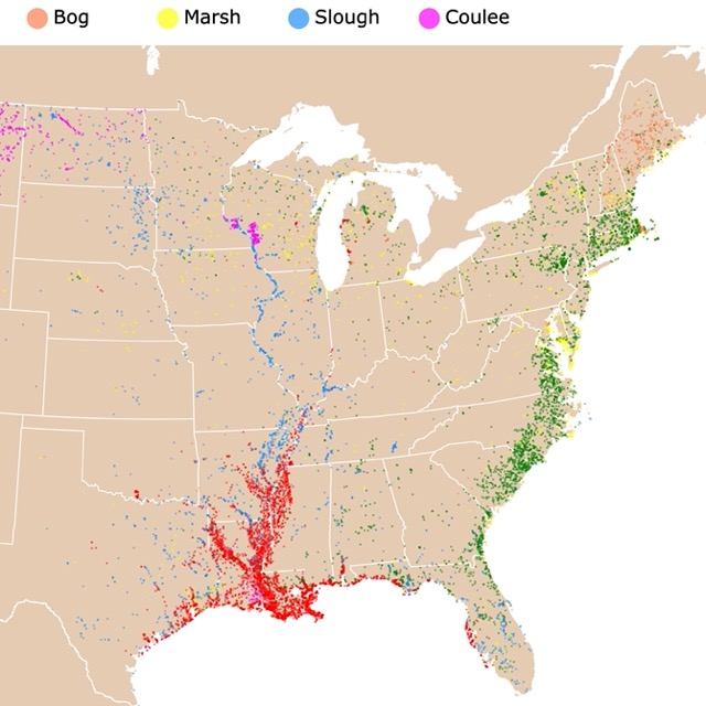
Want to explore wetlands? Check this map of U.S. wetlands
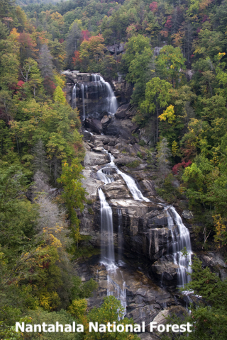
Nantahala National Forest
Nantahala National Forest is located in the southeastern corner of North Carolina.
Nantahala National Forest is located in the mountain and valleys of southwestern North Carolina.
Nantahala is the largest of the state's four National Forests, encompassing over 531-thousand acres.
The uneven topography provides visitors with gorgeous views of the forest.
The forest is divided into three districts: Tusquitee in Murphy, Cheoah in Robbinsville, and Nantahala in Franklin. All of the district's names come from the Cherokee language. Nantahala means "land of the noon-day sun".
With over 600 miles of trails, there is a wide range of outdoor recreational activities at Nantahala, including camping, hiking, mountain biking, horseback riding, and off-road vehicle riding, Nantahala.
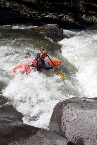
This is the most popular site for rafting, canoeing, and kayaking in the southeastern United States. There are trips for expert rafters and gentle areas for families.
For strenuous hikes Amazon has a variety of hiking shoes. Columbia's Newton Ridge is a durable, breathable, hiking boot. It is waterproof, lightweight, with leather, and mesh.
Gorges State Park
Gorges State Park is the lime area southeast of Nantahala National Forest.
This is a relatively new state park with over 7,000 acres!
Imagine plunging waterfalls, rock walls, rugged river gorges, and numerous rare species in one spot; that's Gorges State Park.
Gorges other features are distance hiking, backpack camping, trout fishing, horseback riding, and mountain biking in the park's irregular topography.
The trails and campsites are continually developing.
Events are held regularly and change seasonally.
The expansive visitor center is an excellent place to begin your adventure. Here, you'll find museum-quality exhibits, places to picnic, and shelters; Gorges.
In a park full of waterfalls and creeks there is no better companion than an action camera. Amazon has the GoPro Hero is a waterproof action camera with image sensor, live streaming, webcam, and stabilization. HERO Black captures the action with crisp detail and cinematic image quality.
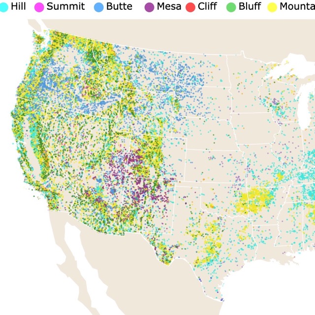
North Carolina's topography has lots of hills and mountains to explore. To learn more, visit this map
Jockey's Ridge State Park
Jockey's Ridge State Park is the lime polygon on the coast, south of Kitty Hawk.
Jockey's Ridge is home to the tallest sand dune on the Atlantic Coast.

The park is an ideal site for kite flying, capturing sunsets, and sightseeing. The views from the ocean to Roanoke Sound are spectacular.
You'll find the museum at the visitor center and a 360-foot boardwalk containing exhibits explaining the dune's ecology.
Thrill-seekers can take hang gliding lessons with a vendor at the park.
The Sound-side of the park is an entirely different experience from the dune. Visitors go sunbathing, paddling, wading, and hiking.
The one-mile nature trail opens up into the wetlands, maritime thickets, and grassy dunes.
The history of the park is fascinating. If it wasn't for people like Carolista Baum stepping up to protest the destruction of this area, we wouldn't have such an incredible place to visit, Jockey.
Merchants Millpond State Park
Merchants Millpond State Park is the lime polygon northwest of Kitty Hawk.
At Merchants Millpond, the southern swamps and hardwood forests blend together.
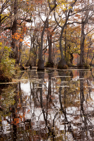
The scenery is beautiful with giant bald cypress trees, Spanish moss, beech groves, and amazing wildlife.
Visitors can bring their own canoe or rent one for a paddle on the water.
Besides paddling, the park has nine miles of hiking trails, with some trail segments open for biking. Fishing is another activity available from the bank or small motorboats.
Family and group campgrounds are available, as well as primitive backpacking sites and remote canoe-in campgrounds.
The picturesque pond is surrounded by picnic areas providing a beautiful backdrop.
The visitor center offers museum-quality exhibits to check out, Millpond.

If you want to learn more about the Atlantic Coast, visit North America's Marine Ecoregions Map
Crowders Mountain State Park
Crowders Mountain State Park is a small lime area west of Charlotte.
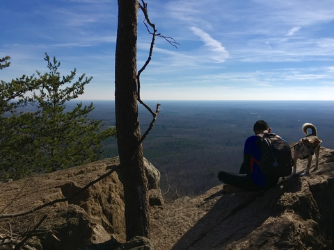
Pinnacle and Crowders Mountain are the main attractions of the park. Both summits offer amazing views and strenuous hikes to visitors.
The challenging hikes have towering cliffs that end in an incredible view of the surrounding piedmont.
The park has 11 trails ranging from pastoral to strenuous, including the Ridgeline Trail that links to Kings Mountain National Military Park and Mountain State Park in South Carolina.
The uneven terrain of Crowders Mountain is excellent for rock climbing and bouldering (with a permit in designated areas).
Backcountry camping is welcome, with individual sites a mile from parking spaces.
The visitor center contains incredible museum-quality exhibits that complement the regular interpretive programs, Crowders Mountain.
South Mountains State Park
South Mountains State Park is the lime green area northeast of Charlotte.
South Mountains State Park is considered one of the state's most irregular areas. The park has elevations of up to 3,000 feet (914m).
There is a hike to the High Shoals waterfall, which is 80-foot (24m) high, plus 40 miles of trails for hiking, biking, and even horseback riding!
The park has 24 backpacking campsites and equestrian camping available. Trailer parking and a barn, complement over 30 miles of bridle trails.
An arduous, 17-mile loop is perfect for mountain bikers searching for a challenge. After a long ride, head to a campsite beside the Jacob Fork River for some fun in the water.
Two picnic areas and a group picnic shelter make lunch in a scenic setting as easy as PB&J, South Mountains.
North Carolina's Parks List
This list includes National Parks, State Parks, National Forests, and other Recreational Areas of North Carolina.
| Type | Name |
|---|---|
| National Parks | Blue Ridge Parkway |
| Great Smoky Mountains National Park | |
| Guilford Courthouse National Military Park | |
| National Seashores | National Seashores |
| Cape Hatteras National Seashore | |
| Cape Lookout National Seashore | |
| Army Corps of Engineers | |
| W. Kerr Scott Dam and Reservoir | |
| State Parks | Cape Hatteras State Park |
| Carolina Beach State Park | |
| Cliffs of the Neuse State Park | |
| Crowders Mountain State Park | |
| Daniel Boone State Park | |
| Dismal Swamp State Park | |
| Duke Powder State Park | |
| Elk Knob State Park | |
| Eno River State Park | |
| Falls Lake State Park | |
| Fort Macon State Park | |
| Goose Creek State Park | |
| Gorges State Park | |
| Grandfather Mountain State Park | |
| Hammocks Beach State Park | |
| Hanging Rock State Park | |
| Jockeys Ridge State Park | |
| Jones Lake State Park | |
| Lake James State Park | |
| Lake Waccamaw State Park | |
| Lumber River State Park | |
| Medoc Mountain State Park | |
| Merchants Millpond State Park | |
| Morrow Mountain State Park | |
| Mount Jefferson State Park | |
| Mount Mitchell State Park | |
| New River State Park | |
| Pettigrew State Park | |
| Pilot Mountain State Park | |
| Raven Rock State Park | |
| Singletary Lake State Park | |
| South Mountains State Park | |
| Stone Mountain State Park | |
| Town Creek Indian Mound State Park | |
| William B Umstead State Park | |
| State Recreation Area | Jordan Lake State Recreation Area |
| State Forests | Bladen Lakes State Forest |
| Rendezvous Mountain Educational State Forest | |
| National Forests | National Forests |
| Croatan National Forest | |
| Nantahala National Forest | |
| Pisgah National Forest | |
| Uwharrie National Forest | |
| National Memorial | Wright Brothers National Memorial |
| National Historic Sites | Carl Sandburg Home National Historic Site |
| Fort Raleigh National Historic Site | |
| National Wildlife Refuges | Alligator River National Wildlife Refuge |
| Cedar Island National Wildlife Refuge | |
| Mackay Island National Wildlife Refuge | |
| Mattamuskeet National Wildlife Refuge | |
| Pea Island National Wildlife Refuge | |
| Pee Dee National Wildlife Refuge | |
| Pungo National Wildlife Refuge | |
| Swanquarter National Wildlife Refuge | |
| National Seashores | National Seashores |
| Cape Hatteras National Seashore | |
| Cape Lookout National Seashore | |
| Army Corps of Engineers | |
| W. Kerr Scott Dam and Reservoir |
FOLLOW ME
Resources for North Carolina's Protected Areas Map
The shapefiles with North Carolina's state boundary lines, lakes, major rivers, and cities were downloaded from Natural Earth Data.
The Parks and Public Lands shapefiles for North Carolina were downloaded from USGS.
This map will be updated with new data! To receive updates on this and more nature maps, join my email list!!!!!!!
Made by Luz K. Molina with D3.js.