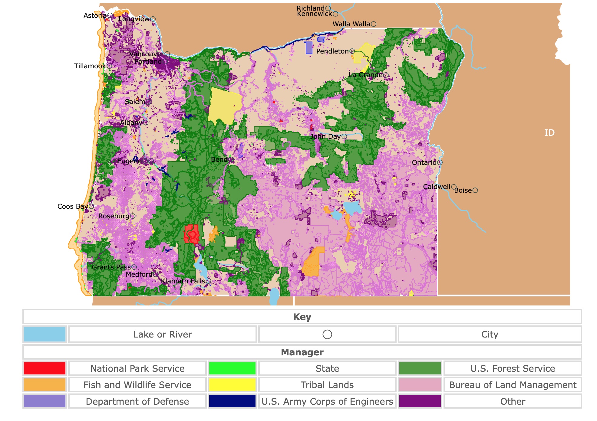
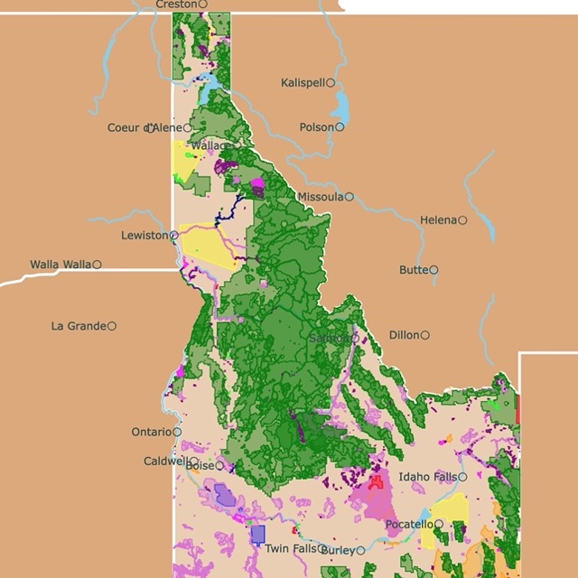
Map of Oregon's Parks and Protected Areas
This interactive map shows the Locations, Names, Areas, and Details of National Parks, State Parks, National Forests, Tribal, and other Public Lands of Oregon. It also shows major cities and rivers for context. For more detail, zoom in. For more information, hover over the map, or scroll down.
| Key | |||||
|---|---|---|---|---|---|
| Lake or River | ◯ | City | |||
| Manager | |||||
| National Park Service | State | U.S. Forest Service | |||
| Fish and Wildlife Service | Tribal Lands | Bureau of Land Management | |||
| Department of Defense | U.S. Army Corps of Engineers | Other | |||
Oregon State Geography
Oregon, in the Pacific North West, is a hugely diverse state geographically, with a wide range of landscapes and waterways. The varied terrain means that the state enjoys a range of climates – from a Mediterranean climate in the southwest to steppe and even a subarctic climate further north.
The "Beaver State" shares borders with California and Nevada to the south, Idaho to the east, Washington to the north, and the Pacific Ocean to the west.
In general, Oregon has a climate far milder than one might expect for its latitude. 60% of the state's residents live in the Willamette Valley, which typically enjoys mild winters and where only small quantities of snow, fall in the area.
The Cascade Range partitions the state. To the west of this mountain range, the climate is strongly influenced by the Pacific Ocean, with an oceanic climate, while there are high desert areas and semi-arid areas to the east of this range.
Broadly speaking, Oregon can be divided into eight geographical zones:
- The Oregon Coast lies west of the Coastal Range.
- The Willamette Valley: Between the Oregon Coast Range mountains and the Cascade Range is a fertile valley characterized by grasslands. The valley is home to 70% of Oregon's population.
- Rogue Valley: This area is known for its salmon runs.
- The Cascade Range: These mountains are part of the Pacific Ring of Fire, which created a series of volcanoes and associated mountains around the Pacific Ocean.
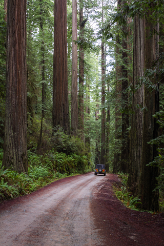
- The Klamath Mountains are located in southern Oregon. They are characterized by diverse wildlife and the most extensive collection of conifers worldwide.
- The Columbia Plateau is between the Cascades and the Rocky Mountains. It is characterized by grasslands.
- The High Desert: This region is desertic compared to the rest of Oregon. Otherwise, it is classified as a scrubland or steppe. Most of it is managed by the Bureau of Land Management and colored in pink on the map above.
- The Blue Mountains: Situated in southern Oregon, they have some of the oldest rocks found in the state.
Notable geographical features include Mount Hood – the highest peak, and the Columbia River. This river forms the state's northern border and is one of the largest rivers in North America.
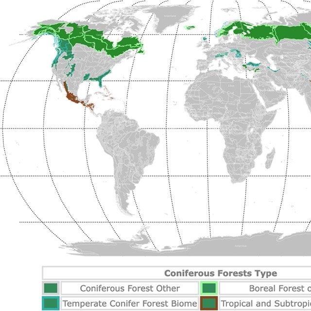
Map of Conifer Forests Worldwide
Oregon Wildlife
This river has played a key role in the natural and human history of this region, what has become known in some circles as the 'Salmon Nation'. This waterway and the Pacific coastline have shaped the region and its people in numerous ways.
The variety of terrain represented in this state makes Oregon incredibly biodiverse. It is home to a wide range of flora and fauna.
Pine forests cover approximately 60% of Oregon, with higher forest density (around 80%) in areas west of the Cascade Range. The state tree is the Douglas fir, and redwoods, western cedar, hemlock, and, to the east, ponderosa pine are also common.
Large mammals play a key role in the state's major biomes, including black bears, foxes, wolves, lynx, cougars, elk, moose, and deer. Beavers are the state mammal, and these shape the environments in which they are found.
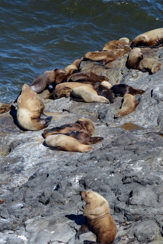
Along the coastline, the coastal waters are home to many more keystone species, including several types of whales, seals, sea lions, and dolphins.
One of the most fascinating organisms in the state, however, is neither a plant nor an animal. It is a vast fungal organism known as Homongous Fungus or Armillaria ostoyae. It lives below Malhuer National Forest in the east of Oregon (northeast of John Day on the map above). It is considered to be the largest single organism in the world. Source: USFS.
Oregon can be a fascinating place to visit year-round. There are natural highlights to be enjoyed through every season.
The summer season (June - August) offers the best weather conditions for outdoor exploration.
But spring wildflowers and fall plenty also make these great times to visit. Winter, while wild, can also be spectacular, and during the off-season, you stand a better chance of having Oregon's natural beauty spots to yourself.
Oregon's Incredible Parks and Forests
Oregon has 10 units managed at least in part by the National Park Service. Several are National Historic Trails that traverse many states, and some straddle state boundaries. Three are also state parks and forests.
Oregon has 11 National Forests, 21 national wildlife refuges, and over 360 state parks.
To ensure we included the best sites in this incredible state, we added the 7 Wonders of Oregon. Why seven wonders? Well, it was a smart campaign to bring visitors to the state.
These wonders are Crater Lake NP, Mt. Hood, The Oregon Coast, The Painted Hills, The Wallowas, Columbia River Gorge, and Smith Rock.
For detailed information about Oregon's outdoors, don't hesitate to get this guide found on Amazon. DeLorme Atlas & Gazetteer: Oregon, has topgraphic maps, scenic drives, trailheads, and even boat ramps. It also includes recreational sites, campgrounds, and fishing areas of the Beaver State.
Crater Lake National Park
Represented in red on the map, Crater Lake National Park is the only national park in the state.
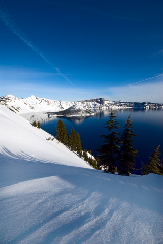
An area of land along the crest of the Cascade Range, this protected area encompasses the remains of Mount Mazama, a destroyed volcano, the caldera of the crater lake, and the hills and forests which surround it.
The Cascade Range formed through volcanic activity due to the movement of the Juan de Fuca and North American plates. Plate tectonics caused the mountain range, topped with a series of volcanoes, to form.
Mount Mazama was one of these volcanoes. It grew to around 11,000 feet (3,400m), surrounded by smaller volcanic peaks and vents. Around 5700 BC, Mazama erupted, forming a huge caldera which later filled to become today's Crater Lake.
The ash it deposited stretched far and wide, providing the soil conditions which today, characterize the region.
Crater Lake is, at 1,945 ft (594m) deep, the deepest lake in the United States. It is the second deepest in North America and the 9th deepest globally.
Crater Lake is also one of the clearest lakes worldwide. UV light penetrates as deep as 320 feet (100 m). This is because it has almost no phytoplankton. Source: craterlakeinstitute.com.
During the summer months, visitors can take boat tours to a volcanic cinder cone that forms an island in Crater Lake. This island, known as 'Wizard Island' rises around 755 ft (230m) above the lake surface and is 6,933 ft (2,113m) above sea level.
This makes Wizard Island the tallest island in the contiguous United States, though there are taller islands in Alaska.
As if this lake did not have enough amazing facts, Crater Lake has another oddity. In its waters, there is a 30ft (9m) hemlock tree stump floating around the lake. It is called "Old Man of the Lake" and its presence has been recorded since 1896! It does not tilt, and it supports a person's weight. The tree is covered in moss found otherwise only at the bottom of the lake.
Though the beautiful blue waters of Crater Lake may look tempting, this is not a suitable swimming spot. The lake has an average temperature in summer of 57.2°F (14°C.) in summer and only 39.2°F (4°C) in spring. Winter's water temperature falls as low as 37.4°F ( 3°C).
The park has two lodges and two campgrounds. Nevertheless, the campgrounds are closed between October and May; Crater Lake.
Want to find places to explore in nearby Idaho? Check this map of Idaho Parks
John Day Fossil Beds National Monument and Painted Hills
This outstanding Oregon National Monument is located in the east-central portion of the state. They are the red specks northwest of John Day.
This protected area, incorporating the Sheep Rock, Painted Hills, and Clarno sites, is famed for its amazingly well-preserved plant and animal fossils. These fossils are the remains of plants and animals which lived in this area between 45 million and 5 million years ago.
Debris flow and lava from volcanic eruptions swept over. They entombed flora and fauna of the area, which means that today, we can gain a picture of the ecology of the distant past by looking at the fossilized remains.
In the Clarno layers, for example, we can see the fossils of tropical and subtropical nuts, fruits, roots, branches, and seeds – revealing that the climate here was once much warmer and wetter. We can also see the fossils of the large mammals which once inhabited these tropical forests.
Later, after the Clarno volcano eruptions had subsided, further volcanic activity in what would become the Cascade Range cast ash and debris over the landscape – and further sediment layers were formed.
Plants and animals were fossilized in the John Day strata, building a picture of a different biodiverse landscape with over 200 mammalian species, including saber-tooth tigers, cats, dogs, camels, and more.
Notable plants in the Sheep Rock site include the Metasequoia (dawn redwood), which was believed to have become extinct worldwide until it was found in China in the early 20th Century.
Within this remarkable protected area, we can build up a picture of what the landscapes and ecosystems here looked like over the millennia.
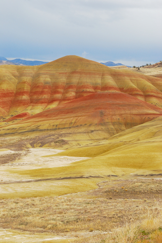
Painted Hills is the unit closest to Bend. The name comes from the yellow, gold, red, and black bands seen on the soil stratification of the hills; John Day
Interested in caves? Click on this link for U.S. caves
Oregon Caves National Monument and Preserve
Close to the Oregon-California border, located around 77 miles southwest of Medford, in the Klamath Mountain Range.
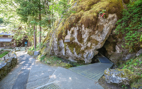
These caves formed in marble have evolved into a network of passages around 15,000ft (4,600m) in length. Some of the caves are open to the public and are a popular tourist destination, though fossils and other fascinating finds have been discovered in areas that are not accessible to visitors.
The bedrock here was originally limestone, though this changed into marble during the geological processes which formed the Klamath Mountains.
The limestone parent rock formed around 190 million years ago, and the caves are believed to have formed a few million years ago, long after plate movements had changed the limestone to marble.
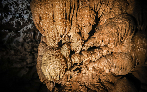
Groundwater seeping through the rock dissolved the tunnels and caverns that can exist today, gradually expanding them over time.
Open year-round, snow and ice can sometimes block access to the park in winter. Cave tours are offered between mid-April and early November.
Camping is provided 4 miles from the entrance. The campground has water and toilets. There are 17 sites with fire rings, but the spaces are too small for RV's. Oregon Caves.
Newberry National Volcanic Monument
Located around 20 miles south of Bend, this monument is within the Deschutes National Forest and is represented in dark green on the map. This protected area conserves a large active shield volcano, the largest volcano in the Cascade Volcanic Arc.
This volcano either formed from an independent hotspot or from the action of the Juan de Fuca and Gorda plates beneath the North American Plate. Scientists have not entirely agreed upon its origins.
What we know is that the volcanic eruption activity here began around 600,000 years ago, and the last eruption was 1,300 years ago. Though it is still considered an active volcano today and is closely monitored.
The Newberry Caldera is a key feature of the park. This caldera holds two volcanic lakes – Paulina Lake and East Lake.
At and around the volcano, there are more than 400 vents, more than any other volcano in the contiguous states. There are also pyroclastic cones, lava flows, and lava domes, making this a site of substantial geological interest.
The landscape, lakes, flora, and fauna of the area also make this a popular spot for various outdoor recreation activities.
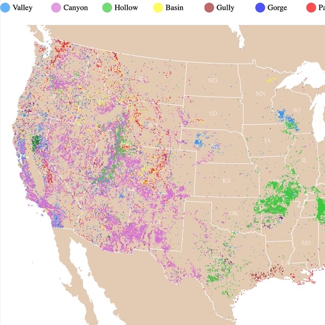
Map of Valleys and Canyons in the U.S.
Hells Canyon National Recreational Area
Hells Canyon National Recreational Area is 357 miles from Portland, on the Oregon-Idaho border. You can see it in green on the map, as it is managed by the U.S. Forest Service as a part of the Wallowa-Whitman National Forest.
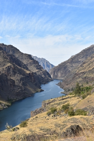
This impressive canyon is the deepest river gorge in North America, rising 7,900 feet (2,133.6 meters) high.
This recreational area protects the historical and archaeological value of the Hells Canyon area along the snake river. Many notable attractions here are found within the Hells Canyon Archaeological District.
In this area, you can see numerous historic buildings, structures, pictographs, and petroglyphs.
Seven of the park's seventeen campgrounds are within Oregon territory. These campgrounds allow visitors to overnight in the area and enjoy its landscapes and features. Numerous hiking trails allow access to the recreational area.
There are also numerous opportunities to explore. You can kayak the white waters of the snake river, enjoy a horseback ride, cycle, fish, indulge in winter sports during the coldest months, or simply take in the magnificent views; Hells Canyon.
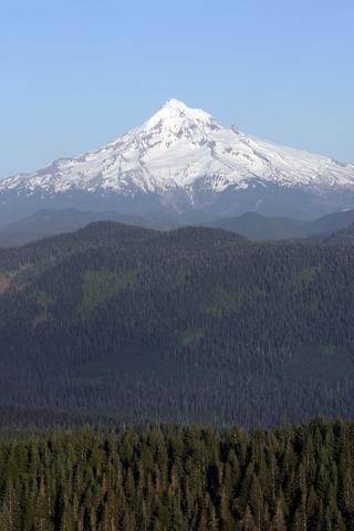
Mount Hood National Forest
Mount Hood National Forest is the green area on the map, 50 miles (80Km) east of Portland.
As mentioned before, Mt. Hood is Oregon's tallest mountain. It has an elevation of 11.249 feet (3,428m). It is also a silent volcano with over 1 million acres of forests, lakes, and streams.
Mt. Hood has several ski resorts and has the country's most extended ski season. Visitors can ski during the summer months. Here, it is possible to go snoweshoeing under the moonlight or traverse the slopes on snowmobiles.
The forest provides opportunities for climbing, kayaking, biking, and hiking.
If you are planning to hike through the trails of Mount Hood or skiing down its slopes, you might find these pants found on Amazon quite convenient. MAGCOMSEN pants are windproof, water resistant, for outdoor hiking and skiing. They are fleece lined, have 5 zipper pockets, scratch resistant, with elastic waste. They will keep you warm in cold weather.
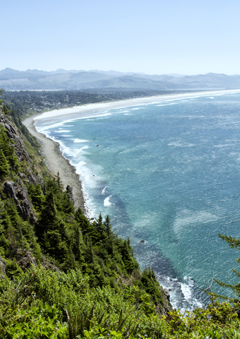
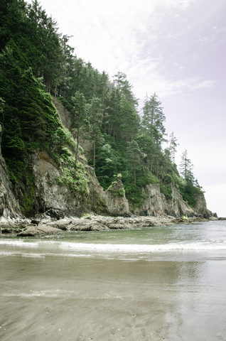
Ecola State Park
Ecola State Park is south of Astoria in northwestern Oregon and marked with purple on the map.
The park offers sightseeing and recreation along 9 miles of the Oregon coastline at Tillamook Head, between Seaside and Cannon Beach.
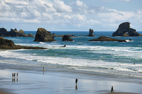
Ecola State Park is famous for its scenic views, stunning sights, and storied past. Trails, including a portion of the Oregon Coast Trail, lead along the coastline to viewpoints, secluded coves, and forested promontories.
On the Clatsop Loop Trail, visitors can also walk in the footsteps of William Clark and his Corps of Discovery.
Delightful picnic spots abound, and the sandy beach of Indian Beach is popular with sun-seekers and surfers.
Watchful visitors can spot all sorts of wildlife throughout the park – from eagles overhead to elk and deer. Grey whales are also visible as they migrate through coastal waters in winter and spring; Ecola SP.
South of Oregon is California, with an array of parks for you to discover.
Oregon Dunes National Recreation Area
Found around 90 miles to the southwest of Eugene, a dark green area on the map shows the location of this site, which is another key destination on the Pacific Coast of the state.
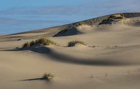
This is a part of the Siuslaw National Forest and adjoins Honeyman State Park. It stretches around 40 miles between the Coos River and the Siuslaw River.
The unique landscape encompasses a series of coastal sand dunes – the most extensive such system in North America, beaches, lakes, marshes, and coastal wetlands.
This landscape of windswept sands has been formed over millions of years by the winds and rains of the Oregon coast.
Visitors can camp, hike, view wildlife, fish, canoe, horseback ride, or use off-highway vehicles; Dunes.
Smith Rock State Park
Smith Rock State Park is the purple speck north of Bend and south of Crooked River National Grassland. Despite the small size of this unit, Smith Rock is one of Oregon's Seven Wonders.
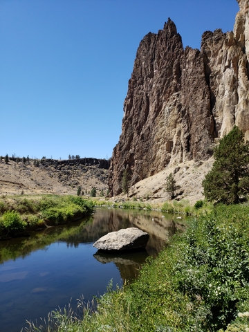
This impressive cathedral-looking outcrop is surrounded by a semi-arid landscape. The rock is made of volcanic ash, which is believed to be the site where climbing became a sport in the U.S.A.
There are several thousand climbs in the outcrop, and many of them are bolted. The cliff is ideal for bouldering, traditional climbing, and sport climbing.
The park has prairie falcons, mule deer, golden eagles, beavers, and otters as dwellers. Some areas may close in spring and summer due to the nesting season of golden eagles and falcons.
Hiking and biking are other popular activities at the park. Nevertheless, due to the park's popularity, it is hard to park during peak days in the summer.
The park is open throughout the year, with picnic and camping sites; Smith Rock.
Silver Falls State Park
Silver Falls is the purple polygon east of Salem in northwestern Oregon.
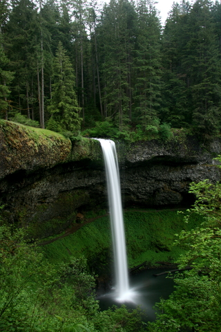
This is the "Crown Jewel" of the Oregon State Park system, as the park has 10 waterfalls, with 5 over 100 feet (30m) in a single trail!
Visitors need to walk a 6+ mile trail down a rocky canyon with over 700 feet (54m) in elevation to see them all. You can skip 2 falls and hike under 3 miles. If you prefer a more laid-back walk.
One of its famous cascades is South Falls, with a 177-foot curtain that visitors can see from behind.
The park offers campgrounds open between May and October, but the park is open year-round; Silver Falls.
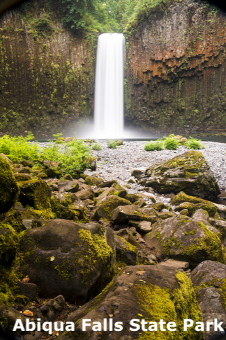
Just north of Silver Falls is Abiqua Falls, adjacent to the Forest Development Fund, in purple. The area is not a park, but it is usually open for visitors.
The track is challenging, rough, and dangerous. People have even died on its steep slopes. But the lure to this fascinating site is not just the falling waters.
The rock surrounding the falls is made of volcanic sediment that formed incredible basalt columns as it cooled down.
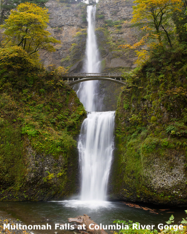
Columbia River Gorge National Scenic Area
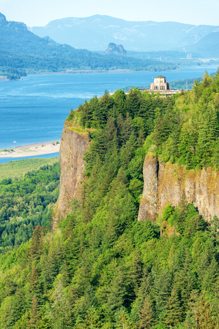
This area is on the northern border of Oregon, along the Columbia River, and is depicted in green on the map.
The views from the Columbia River are impressive, as its waters cut through the Cascade mountains, forming cliffs, spires, and an impressive canyon 4,000 feet (1,200m) deep, and 80 miles (128Km) long.
Trails along its shores are suitable for hikers and bikers of different levels. These paths cross waterfalls, including Multnomah, Bridal Veil, and Latourell Falls.
The area is known for windsurfing, kiteboarding, paddleboarding, kayaking, fishing, nature viewing, and wineries.
The Forest Service has 2 campgrounds within the National Scenic Area. They offer a total of 44 campsites for visitors that wish to stay overnight.
For flights and stays to the Columbia River Gorge, Expedia has different packages. For details and prices click here!

Map of U.S. Lakes and Ponds
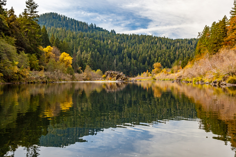
The Wallowas or Wallowa-Whitman National Forest
The Wallowas are in Oregon's northeastern corner, depicted in green on the map. It is composed of the Wallowa Lake State Park surrounded by Wallowa National Forest.
This is the land of contrast, from the Alpine peaks to the grasslands, conifer forests, watersheds, and semi-deserts, to Hells Canyon surrounding the Snake River.
Besides the vistas, there is the wilderness and the memories of the Oregon Trail. The area has hardly changed since the days of the pioneers.
Wallowa Lake State Park is a glacial lake surrounded by Wallowa Mountains. It is a significant day-use area with fishing, swimming, boating, and kayaking.
The forest and the park have campsites for visitors to spend the night.
Nahalem Bay State Park
Nahalem Bay State Park is the lime speck south of Astoria.
This park is situated along the bay and Neakahinie Mountain. The park has a four-mile sand spit along the shore.
The park is home to elk, deer, seals, and the snowy plover. In fact, some areas may be closed due to the plovers' nesting season.
The Nehalem Bay trail is 1.8 miles. The Nehalem Spit Trail is 5.2 miles and traverses the sand pit and a jetty.
Besides hiking and wildlife viewing, the park is excellent for horseback riding, fishing, crabbing, biking, and beachcombing.
The park has one of the most extensive campgrounds in the state, with 265 electrical sites; Nahalem.

Map of North America's Marine Ecoregions
Oswald State Park
Oswald state park is a purple speck south of Astoria and just north of Nahalem State Park.
This is a true hidden gem. It has miles of sandy beaches and incredible views of and from the volcanic basalt and sandstone cliffs. Furthermore, the coast is surrounded by beautiful temperate rainforests.
As visitors walk through the park, they can check the rocks with gray and black from cooled lava and pink with beige from the sandstone.
The park has fantastic views and over 13 miles of trails with various difficulty levels.
One of the locals' favorite activities at the park is surfing! But the park is also popular for fishing, beachcombing, boating, and hiking, Oswald.
Valley of Rogue River State Park
In southern Oregon, between Medford and Grants Pass, is the Rogue River, depicted in pink.
This might be the most overlooked park in Oregon. The park is a popular site for water recreation thanks to the whitewater rapids. These offer great opportunities for rafting and kayaking.
The park has a short relaxing trail of 1.25 miles and a rough one for visitors looking for more than scenic views.
The park has campgrounds with hookup sites and even yurts to spend the night! Valley of the Rogue.
This and other parks in Oregon have wet trails and damp areas. For these landscapes, Amazon has the Merrell's Moab hiking boots to keep you dry. They are waterproof with a breathable mesh lining. They are lightweight and have a reinforced heel cushion that absorbs shock and adds stability.
FOLLOW ME
Resources for Oregon's Protected Areas Map
The shapefiles with Oregon's state boundary lines, lakes, major rivers, and cities were downloaded from Natural Earth Data.
The Parks and Public Lands shapefiles for Oregon were downloaded from USGS.
This map will be updated with new data! To receive updates on this and more nature maps, join my email list!!!!!!!
Made by Luz K. Molina with D3.js.