Map of Michigan's Protected Areas
This interactive map shows the Locations, Names, Areas, and Details of National Parks, State Parks, National Forests, Tribal, and other Public Lands of Michigan. It also shows major cities and rivers for context. For more detail, zoom in. For more information, hover over the map, or scroll down.
| Key | |
|---|---|
| Lake or River | |
| ◯ | City |
| Manager | |
| National Park Service | |
| State | |
| U.S. Forest Service | |
| Fish and Wildlife Service | |
| Tribal Lands | |
| Bureau of Land Management | |
| Department of Defense | |
| U.S. Army Corps of Engineers | |
| Other | |
Michigan's Geography
Michigan, the mitten-shaped state, consists of two separate peninsulas. The Upper Peninsula is bordered on the north by Lake Superior and to the south by Lakes Huron and Michigan. Wisconsin borders the Upper Peninsula to the west.
To the north, beyond the Great Lakes is Canada's Ontario Province.
To the south Michigan shares borders with the states of Ohio, Indiana, and Illinois.

Glaciers were responsible for the famous mitten shape of Michigan.
Thousands of years ago, glaciers from the ice age melted, and as they did they carved out the landscape, changed the shape of the surrounding water, and created lakes and rivers, Michigan Nature.
Michigan is one of the leading manufacturing states, and is is also a leading tourist state.
Michigan is surrounded by four of the five Great Lakes, and it also supports more than 11,000 other lakes.
The two land areas of Michigan provide the state a shoreline of over 3,000 miles (4,828 km), which is second in length to Alaska.
The upper and lower peninsula are connected by the five-mile-long Mackinac Bridge.
The Lower Peninsula is part of the Great Lakes Plains that stretch along the Great Lakes, from Michigan and Wisconsin to Ohio.
This region is fairly level, but visitors will find low rolling hills in the south.
In the north, the area changes to a northern tableland of hilly belts. The lowest point in the state is along the shore of Lake Erie and is found in the Lower Peninsula.
The Upper Peninsula of Michigan is level and contains swampy areas in the east.
The western area of the Upper Peninsula is known as the Superior Upland. This area achieves higher elevations, and the terrain gets more rugged.
The Superior Upland runs along Lake Superior and into the Porcupine Mountains of northwestern Michigan. Mount Arvon in the upper peninsula is the highest point with 1,979 feet (603 meters) in elevation.
For more information about Michigan, Amazon has Michigan State Profiles. In this title, engaging text and vivid photos combine to show off Michigans landscape, history, and culture.
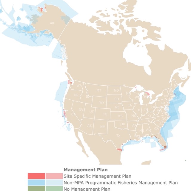
Michigan has a long coastline. To learn more about it, check this map of U.S. Marine Protected Areas
Climate
It's interesting how the Great Lakes cool the hot winds of the summer, but they also warm the cold winds of winter, providing Michigan with more of a moderate and moister climate than some of the north-central states.
While the Upper Peninsula is cooler, the temperatures in the state's far northern and southern cities don't excessively differ.
In the far north of Michigan in Sault Sainte Marie, January's high temperatures are typically in the low 20s F (-6°C), and the lows hover around 5°F (-15°C).
July temperatures get up into the mid-70s F (24°C) and drop down into the 50s F (11°C) daily.
In the southeast of Michigan, Detroit's January high temperatures average around the low 30s F (1°C), and the lows drop to about 20°F (-7°C).
July temperatures in Detroit average somewhere in the mid-80s F (about 29°C), with the lows in the mid-60s F (18°C).
The average annual precipitation in Michigan ranges between 30 to 38 inches (760-965 mm). The southwest portion of the state is the wettest, with rainfall decreasing toward the northeast.
Alpena is located in the northeastern Lower Peninsula, and it's one of the driest places in the U.S., east of the Mississippi River.
There are two lake-effect snow belts in Michigan; one on the south shore of Lake Superior, in the Upper Peninsula, and the other on the eastern shore of Lake Michigan, in the Lower Peninsula Geo Michigan.
Plants and Wildlife
Michigan is full of incredible plants and animals. There is a lengthy list of rare animals in the region as well. Some of the rare animals include the gray wolf, short-eared owls, long-eared owls, and Fowler's toad. Many of the animals on the rare list are endangered or threatened, MSU.
Some of the common plants in Michigan include bloodroot, the compass plant, common milkweed, and various wildflowers. White birch and jack pine are a couple of trees native to the area.
Birds like Kirtland's warbler are one of the rarest in the wood warbler family, and it's also one of the rarest songbirds, so birdwatchers, be prepared, All About Birds.
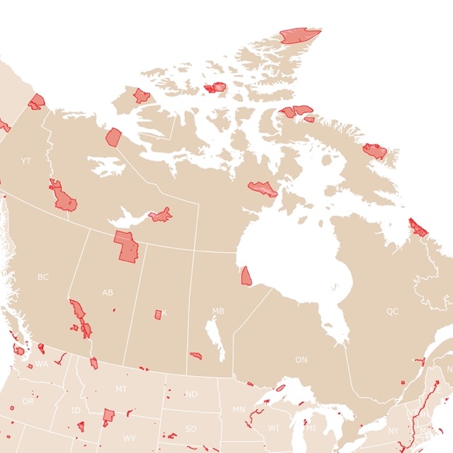
Want to find places to explore in nearby Canada? Check this map of Canada Parks
National Parks of Michigan
For details on every park depicted above Amazon has Michigan Bucket List Adventure Guide: Explore 100 Offbeat Destinations You Must Visit! With this book you will be able to enjoy and discover every landscape and magical place in the different regions in Michigan without getting lost!
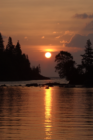
Isle Royale National Park
Isle Royale National Park is the long island depicted in red on Lake Superior.
The rugged and isolated island is beyond the sounds and sight of civilization.
It offers countless adventures for hikers, backpackers, canoeists, kayakers, and scuba divers. Reflect, discover, explore, and enjoy the scenic park and all of its beauty.
The only way to reach Isle Royale is by crossing Lake Superior. Once you arrive, there are numerous ways to explore the archipelago by land and water. You can get to the island by personal boat, ferry or seaplane.
If you're a fan of backpacking, you can set up a basecamp and explore the island throughout the day, then return to camp for a beautiful evening.
If you prefer to stay on the move, you can paddle or hike to a new campground every day. Cruise up to a dock and tie your boat up for a night on the water.
The Rock Harbor Lodge offers two restaurants; the Lighthouse Restaurant and Greenstone Grill. There are camp stores in Rock Harbor and Windigo where visitors can get basic camping supplies.
The cool climate, crystal-clear water, and the lush North Woods Forest characterize the Isle Royale National Park.
The total area of 850 square miles includes submerged lands that extend more than four miles out into the beautiful Lake Superior. 99% of the landmass in the area is federally designated wilderness.
The archipelago comprises numerous parallel ridges, which are the results of ancient lava flows that were tilted and glaciated.
The island also holds more than 100 ponds with walleye, perch, and trout.
With 165 miles of stunning hiking trails and 36 campgrounds, paddlers, backpackers, and recreational boaters never get bored. Go fishing, visit the historic lighthouses, shipwrecks, ancient copper mine sites, and numerous areas for observing the wildlife, Isle Royale.
Because this is an isolated location you will find incredible cottages and cabins with spectacular views of the lake and the woods. For options and locations visit VRBO!
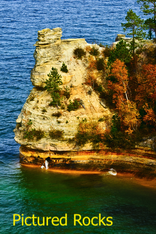
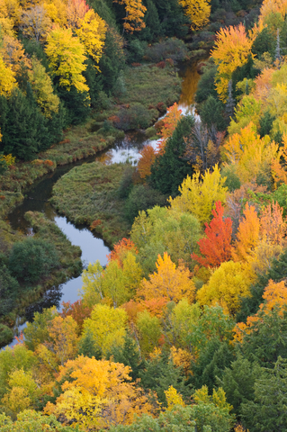
Pictured Rocks National Lakeshore and Beaver Basin Wilderness
Pictured Rocks National Lakeshore and Beaver Basin Wilderness is the red stripe on the southern shores of Lake Superior.
Beaver Basin Wilderness and its 11,740 acres were proposed as a part of the 2004 General Management Plan, providing permanent legal protection for this part of the lakeshore.
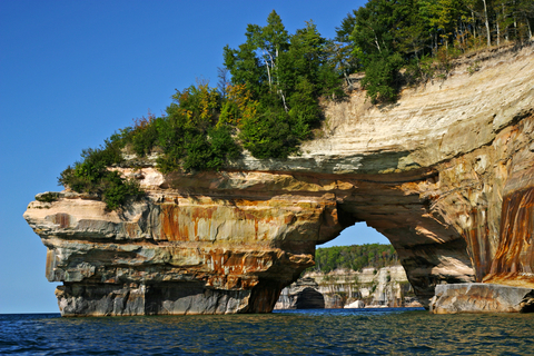
This park is notable, as it has miles of beautiful beaches, towering sandstone cliffs, lakes, waterfalls, and deep forests.
Hunting, day hiking, fishing, canoeing, overnight backpacking, kayaking, snowshoeing, and cross-country skiing are just a few of the recreational activities visitors enjoy.
The park contains three incredibly clear lakes, Beaver Lake (762 acres), Trappers Lake (45 acres), and Legion Lake (35 acres. Five cold water streams can be found throughout the park, including Arsenault Creek, Lowney Creek, Little Beaver Creek, Beaver Creek, and Sevenmile Creek.
The extensive wetlands and clear streams provide beautiful habitats for native coaster brook trout, bass, northern pike, white sucker, and many other fish species. Old-growth cedar swamps are important for the white-tailed deer in the area.
Beech-maple grows throughout the upland hardwood forest, providing a habitat for various mammals, birds, and flowering plants.
Travel the land to explore the pattern of glacial geology, including the post-glacial meltwater channels, Lake Nipissing beach ridges, and escarpments Pictured Rocks.
This is a sought after area. You may need to reserve in advance. To find the perfect location for an unforgettable vacation in summer or winter visit Expedia!
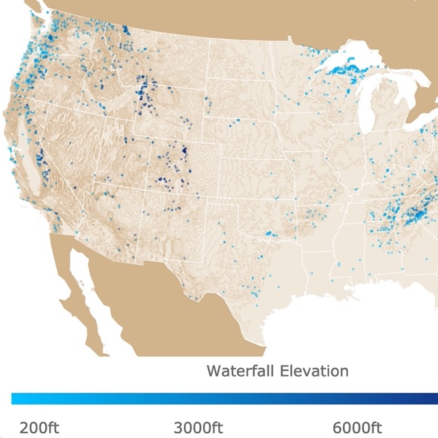
Michigan has beautiful falls. To find more, visit this link for a map of U.S. Waterfalls!
Sleeping Bear Dunes National Lakeshore Michigan
Sleeping Bear Dunes National Lakeshore Michigan is the red stripe on the eastern side of Lake Michigan.
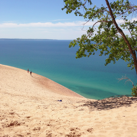
Incredible bluffs of 450 feet (137 meters) over Lake Michigan, miles of sandy beaches, dense forests, unique flora and fauna, and crystal clear lakes are the main features of Sleeping Bear Dunes
.The high dunes provide a stunning view of the area, while the presence of a lighthouse and other buildings like coastal villages reveal the maritime history of the park.
There are a few different campsites to choose from, including a day camp area. Platte River Campground offers electric hookups, showers, and modern restrooms.
The D.H. Day Campground is rustic, with dirt roads and vault toilets. The Manitou Islands are a hot spot for visitors, Sleeping Bear Dunes.
You may find nearby stays and many others in the surrounding areas. From Bed & Breakfasts to Hotels and Motels. For prices and locations visit Hotels.com.
State Parks and Forests of Michigan
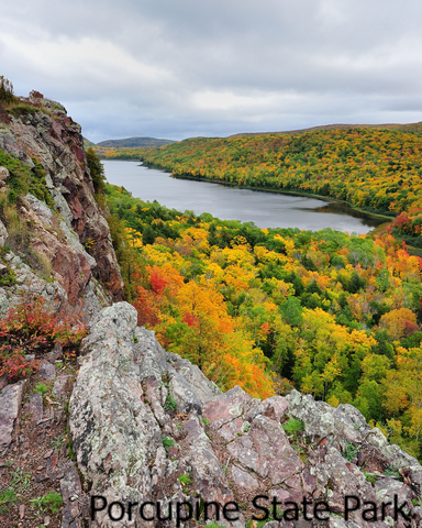
The Porcupine Mountains Wilderness State Park
Porcupine is on the northwestern corner of the state. It is the lime green polygon on Lake Superior.
With around 60,000 acres, Porcupine Mountains Wilderness State Park is the largest state park in Michigan.
The park is also one of the few remaining wilderness areas in the Midwest. The area is home to a 35-thousand acre old-growth forest, miles of streams and rivers, and roaring waterfalls.
Visitors can hike over 90 miles of trails, and there's both a modern and rustic campground. Backcountry camping is available for those who prefer to rough it.
Lake Superior's shoreline is a popular area during the summer, while the Presque Isle River corridor is excellent for relaxing.
With many natural attractions, including the Lake of the Clouds, it's easy to see why so many people are attracted to the area, Michigan.
The Summit Peak observation tower, Porcupine Mountains Ski Area, and an 18-hole disc golf course are a few of the many recreational activities to enjoy.

For more lakes around the U.S. visit this map of Lakes and Ponds
Huron-Manistee National Forests
The Huron-Manistee National Forest (HMNF) is south of Alpena on the western shores of Lake Huron.
The national forest lies between the shores of Lake Huron and Lake Michigan, in the northern half of the Lower Peninsula. The park offers year-round non-motorized and motorized recreation opportunities for outdoor enthusiasts.
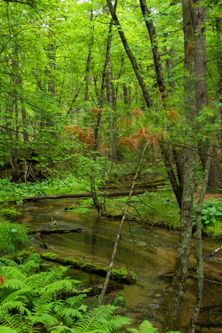
The most popular areas of the forest are the campgrounds and trails along with the 4 nationally designated scenic and wild rivers, including the Manistee, Au Sable, Pere Marquette, and the Pine.
The HMNF is home to incredible species such as Kirtland's warbler, karner blue butterflies, pitcher's thistle, and piping plover.
There are over 600 miles of trails available for snowmobiling during the winter. The winter months are also prime-time for cross-country skiing and snowshoeing on more than 300 miles of trails.
Besides skiing, ice fishing is another popular activity during the winter months.
Don't forget to check the calendar because there are designated free days, where the fees for day use are waived, Forest Service.
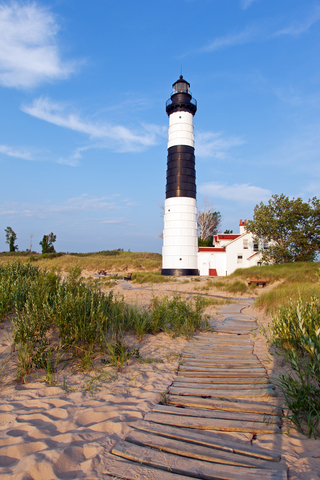
Ludington State Park
Ludington State Park is a lime green park, between Lake Michigan and Hamlin Lake.
This state park has beautiful sand dunes, miles of sandy beaches, wetlands, marshlands, forests, and an iconic lighthouse.
The park offers ample opportunity for wildlife viewing from the extensive trail system, as well as a metal detecting area.
Ludington offers numerous attractions, hikes, classes, and interpretive programs all year. Visitors are given the opportunity to learn about the Great Lakes, sand dunes, the history of Big Sable Point Lighthouse, and lumber town.
Some of the accessible features of the park include a playground, the beach, a mini-cabin, a fishing pier, and modern restroom facilities, Ludington.
Looking for more places to ski? Go to this map of Ski Resorts in North America
Tahquamenon Falls State Park
Tahquamenon Falls State Park is located in northern Michigan. It is the lime-green polygon on Lake Superior and east of the Beaver Basin Wilderness.
This beautiful state park boasts close to 50-thousand acres of land stretches over 13 miles (20.9 Km). Most of the area is undeveloped woodland without roads, power lines, or buildings.
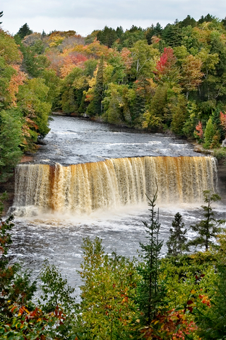
The centerpiece and the reason for the park's existence are the Tahquamenon River and its waterfalls.
The Upper Falls is one of the largest waterfalls east of the Mississippi River. It spans over 200 feet (60.96 meters) across and has a drop of nearly 50 feet (15.24 meters).
The maximum flow of the waterfall is recorded at over 50,000 gallons of water per second. Four miles downstream of the Upper Falls is the Lower Falls, a series of five smaller falls cascading around an island.
While the Lower Falls isn't as dramatic as the Upper Falls, they are just as popular and stunning. The falls can be seen from the river bank or the island.
Visitors need a rowboat to reach the island, which can be rented from a park concession area. The island walk provides stunning views of the falls in the south channel.
Visitors can enjoy year-round camping with some sites offering electric service.
Tahquamenon's Track Chair allows visitors to explore areas of the park where traditional wheelchairs might not be able to make it. The chairs are available on a first-come, first-serve basis, for absolutely free! Tahquamenon
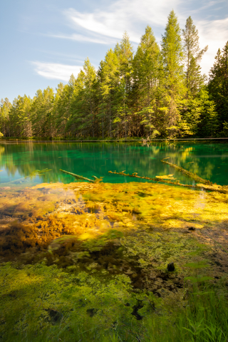
Palms Book State Park
This beautiful park is the small lime green area between Lake Superior and Lake Michigan.
Palms Book makes an excellent side trip for those visiting the Upper Peninsula.
This location is known as one of Michigan's most alluring natural attractions. The park is home to the Kitch-iti-kipi or the Big Spring.
It's the state's largest freshwater spring at 100 feet (30.48 meters) across and 40 feet (12.19 meters) deep.
The spring flows all throughout the year and remains at a constant temperature of 45°F (4.44°C).
Map of Grasslands Worldwide
List of Parks in Michigan
This list includes National Parks, National Forests, State Parks, and other Preserved areas in Michigan.
| National Parks | |
|---|---|
| Isle Royale National Park | |
| National Lakeshore | |
| Pictured Rocks National Lakeshore | Sleeping Bear Dunes National Lakeshore |
| National Trail | |
| North Country National Scenic Trail | |
| National Historic Site | |
| Motor Cities National Heritage Area | Keweenaw National Historic Park |
| River Raisin National Battlefield Park | |
| State Parks | |
| Albert E Sleeper State Park | McLain State Park |
| Algonac State Park | Michilimackinac State Park |
| Aloha State Park | Mitchell State Park |
| Baraga State Park | Muskallonge Lake State Park |
| Bay City State Park | Muskegon State Park |
| Benzie State Park | Newaygo State Park |
| Bewabic State Park | North Higgins Lake State Park |
| Brimley State Park | Onaway State Park |
| Burt Lake State Park | Orchard Beach State Park |
| Charles Mears State Park | Otsego Lake State Park |
| Cheboygan State Park | P H Hoeft State Park |
| Clear Lake State Park | P J Hoffmaster State Park |
| Craig Lake State Park | Palms Book State Park |
| D H Day State Park | Petoskey State Park |
| De Tour State Park | Porcupine Mountains Wilderness State Park |
| Dodge Brothers State Park Number 2 | Port Crescent State Park |
| Dodge Brothers State Park Number 8 | Saugatuck Dunes State Park |
| Fisherman's Island State Park | Seven Lakes State Park |
| Fort Custer State Park | Silver Lake State Park |
| Fort Michilimackinac State Park | Sleeper State Park |
| Fort Wilkins State Park | Sleepy Hollow State Park |
| Gogebic Lake State Park | Sterling State Park |
| Grand Haven State Park | Straits State Park |
| Harrisville State Park | Sturgeon Point State Park |
| Hartwick Pines State Park | Tahquamenon Falls State Park |
| Hayes State Park | Tawas Point State Park |
| Higgins Lake State Park | Traverse City State Park |
| Hoeft State Park | Twin Lakes State Park |
| Hoffmaster State Park | Van Riper State Park |
| Holland State Park | Walter J. Hayes State Park |
| Indian Lake State Park | Warren Dunes State Park |
| Interlochen State Park | Warren Woods State Park |
| J W Wells State Park | Wild Fowl Bay State Park |
| Lakeport State Park | Wilderness State Park |
| Leelanau State Park | William Mitchell State Park |
| Ludington State Park | Wilson State Park |
| Mackinac Island State Park | Young State Park |
| State Forests | |
| Allegan State Forest | Pigeon River State Forest |
| Au Sable State Forest | Thunder Bay River State Forest |
| Baraga State Forest | State Reserve |
| Black Lake State Forest | Beaver Islands Wildlife Research Area |
| Houghton Lake State Forest | State Wildlife Area |
| Kalkaska State Forest | Unadilla Wildlife Area |
| Lake Superior State Forest | State Wildlife Management Area |
| Manistique River State Forest | Onsted Wildlife Mgmt. Area |
| Munuscong State Forest | National Parks |
| Pere Marquette State Forest | |
| National Forests | |
| Hiawatha National Forest | Manistee National Forest |
| Huron National Forest | Ottawa National Forest |
| National Wildlife Refuges | |
| Huron National Wildlife Refuge | Seney National Wildlife Refuge |
| Michigan Islands National Wildlife Refuge | Shiawassee National Wildlife Refuge |
FOLLOW ME
Resources for Michigan's Protected Areas Map
The shapefiles with Michigan's state boundary lines, major rivers, and cities were downloaded from Natural Earth Data.
The Parks and Public Lands shapefiles for Michigan were downloaded from USGS.
This map will be updated with new data! To receive updates on this and more nature maps join my email list!!!!!!!
Made by Luz K. Molina with D3.js.
